
You are using an out of date browser. It may not display this or other websites correctly.
You should upgrade or use an alternative browser.
You should upgrade or use an alternative browser.
Photos of Clouds and Skies (That you took yourself)
- Thread starter Mick West
- Start date
Kind of look like they might be shadows cast by some Kelvin Helmholtz cloudsNot sure if these are crepuscular rays or just shadows...or even what the difference is...but still pretty cool nonetheless.
View attachment 37855
Pretty patterns yesterday evening. The dots across the top left corner are the remnants of another contrail that had split into vortex rings.

They drifted off pretty quickly, this is five minutes later:

They drifted off pretty quickly, this is five minutes later:
Straight edged cloud ")
Actually a neat shadow effect from the Shard this morning.

Actually a neat shadow effect from the Shard this morning.
JMartJr
Senior Member.
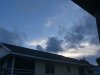
Not hugely dramatic, but a nice example of low level clouds at sunset already shaded by the Earth,, while higher clouds are still in the sunlight.
Plus gives me a chance to see if, as a new member, I can post a picture correctly.
EDIT to clarify pic is at sunset.
Plus gives me a chance to see if, as a new member, I can post a picture correctly.
EDIT to clarify pic is at sunset.
Attachments
Last edited:
JMartJr
Senior Member.
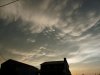
While looking for the one time I got pics of anticrepuscular rays, I found a couple of other good pics that are on topic -- what I am thinking are mammatus clouds, and what seems to be a shadow cast by some out-of-sight cloud across the rest of the cloudscape at sunset. And then I found the rays, too. And that's it for me.
Attachments
Last edited:
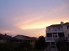
I took this picture on March of 2013 from my backyard. Posted it to FB and it went around the world. I even saw posts by celebrities that had re-posted this image. Clearly it looks like something heavenly?")
Funny, as I saw your post, I looked out my window and saw something similar.
As I'm sure you know, these clouds are called Cirrus Virga. Every now and then one of them looks like an angel - especially as they rapidly change shape as they move across the sky. Here it is a few minutes later.
Rocky
Active Member
Of course. I knew what it was but the reactions were just unbelievable. People will see what they want to see. Here in Florida we have some awesome twilight skies. When I posted it to FB I was getting contacted from all over the world. I am an I.T. professional and my colleagues and I got such a big kick out of watching where we would find it next on the internet.
cloudspotter
Senior Member.
I took this photo last August in Lot et Garonne, south west France. I had never seen a cloud formation quite like this before, but we do get some interesting and beautiful 'cloud displays' here.View attachment 41257
Hi @starlet. Beautiful photo - those are Pileus clouds created by the big clouds forcing air flow above them upwards to the point where it cools enough for clouds to form
https://en.wikipedia.org/wiki/Pileus_(meteorology)External Quote:
Thank you so much for the info, it's fascinating. I have just googled Pileus clouds and seen some great pictures. I can see why they are named after the Roman hat!Hi @starlet. Beautiful photo - those are Pileus clouds created by the big clouds forcing air flow above them upwards to the point where it cools enough for clouds to form
https://en.wikipedia.org/wiki/Pileus_(meteorology)External Quote:
Leifer
Senior Member.
How about the nearly black clouds in front of the white billows? Why are they almost black ?I took this photo last August in Lot et Garonne, south west France. I had never seen a cloud formation quite like this before, but we do get some interesting and beautiful 'cloud displays' here.View attachment 41257
(I kinda know why, but I'd like to hear other explanations..without prompting.)
Last edited:
I have wondered about the dark clouds too. I think that the camera auto exposure has probably over compensated due to pointing at the sky, therefore darkening the clouds, but those clouds were pretty dark anyway.How about the nearly black clouds in front of the white billows? Why are they almost black ?
(I kinda know why, but I'd like to hear other explanations..without prompting.)
All clouds that are made up of water vapor and are in liquid phase look the same at small scale. It's just water vapor.
Growing up in coastal LA, I got to see nearly every cloud type. The "June Gloom" is quite instructive: a low stratus cloud that when viewed from below (like in the coastal areas or out on the water) looks like the standard "June Gloom" cloud (grey, "gloomy", and flat underbelly), when it's on the ground (like at slightly higher elevations in LA) it's a dripping grey fog, and when near the top (as when driving up to 900'-elevation Pasadena from 200'-elevation downtown) gets thinner and brighter as you approach the top of the stratus, then finally bright sunny daylight and now the cloud's below. Above that cloud deck, the deck is in full sun and very bright, often pretty flat as well, since it's a stratus. (As a side note, the June gloom, which often goes from April through September, is one of the reasons why I now live in Phoenix!)
In the photo above, the towering cumulus (correctly called cumulus congestus, but I like towering better) in the background is a rapidly growing (vertically) plume of water vapor. The pileus clouds on top are really neat, they represent strong horizontal winds at high level that are entering a wave of compression above the approaching cumulus pile and as the towering cumulus enters that layer, may start to shear to image-right and begin to form a cumulonimbus.
The towering cumulus is obviously in full low-angle daylight. The clouds in the foreground are far less substantial wisps, where water vapor has accumulated, but are in shadow likely due to other clouds between them and the low sun. In shadow means they're not directly illuminated, so against the fully illuminated towering cumulus they're far far far dimmer.
The huge difference in luminosity between the towering cumulus cloud in the background and everything else in the image is definitely a factor in the camera's computer. The trees and foliage in the foreground are almost certainly not black! They're just nowhere near as illuminated as the cloud.
Cheers - Jon N7UV
Thank you Jon, that was an interesting read and I have learned a lot. Yes, the picture was taken quite late in the day (8.30 in the evening) which would account for the clouds being in shadow.All clouds that are made up of water vapor and are in liquid phase look the same at small scale. It's just water vapor.
Growing up in coastal LA, I got to see nearly every cloud type. The "June Gloom" is quite instructive: a low stratus cloud that when viewed from below (like in the coastal areas or out on the water) looks like the standard "June Gloom" cloud (grey, "gloomy", and flat underbelly), when it's on the ground (like at slightly higher elevations in LA) it's a dripping grey fog, and when near the top (as when driving up to 900'-elevation Pasadena from 200'-elevation downtown) gets thinner and brighter as you approach the top of the stratus, then finally bright sunny daylight and now the cloud's below. Above that cloud deck, the deck is in full sun and very bright, often pretty flat as well, since it's a stratus. (As a side note, the June gloom, which often goes from April through September, is one of the reasons why I now live in Phoenix!)
In the photo above, the towering cumulus (correctly called cumulus congestus, but I like towering better) in the background is a rapidly growing (vertically) plume of water vapor. The pileus clouds on top are really neat, they represent strong horizontal winds at high level that are entering a wave of compression above the approaching cumulus pile and as the towering cumulus enters that layer, may start to shear to image-right and begin to form a cumulonimbus.
The towering cumulus is obviously in full low-angle daylight. The clouds in the foreground are far less substantial wisps, where water vapor has accumulated, but are in shadow likely due to other clouds between them and the low sun. In shadow means they're not directly illuminated, so against the fully illuminated towering cumulus they're far far far dimmer.
The huge difference in luminosity between the towering cumulus cloud in the background and everything else in the image is definitely a factor in the camera's computer. The trees and foliage in the foreground are almost certainly not black! They're just nowhere near as illuminated as the cloud.
Cheers - Jon N7UV
June gloom! We seemed to have that more or less permanently in the UK too, hence the move to the south of France. Much better!
Except for the ice clouds, like cirrus, which are made of water in the solid phase.All clouds that are made up of water vapor and are in liquid phase look the same at small scale. It's just water vapor.
"Water vapor" is technically water in the gas phase - an invisible gas that's present in air in various concentrations. Clouds are made from water vapor, not of water vapor.
Although in the vernacular, "water vapor" and "steam" are often used to refer to clouds of water droplets that condensed from the gas. But when you are getting into debunking misconceptions (like "chemtrails") it's important to both understand what people mean, and communicate with them using terms that are both accurate and understandable.
It's too late now for your particular image, but if you have the capability to set up a time-lapse camera (a camera that takes shots every 10-60 seconds or so) the intricacy of the dynamic atmosphere is pretty impressive and it can help to visually demonstrate what is/may be going on.
It does look like the air at that level is moving from image-left to image-right. The air at that level is near dew point and as those parcels ride up over some small ridges the air in the parcels drop in pressure and/or temperature and the gaseous water turns to liquid water (as teeny droplets) and the cloud forms. Once over whatever atmospheric hump is there, the parcel drops in elevation just enough to allow the liquid water to evaporate and go back to gaseous.
Why the humps are there is hard to know without knowing a lot more about the atmosphere at that particular moment.
I will soon have back on-line one of my cameras with software that captures an image of the view west of Phoenix (AZ, USA). Every 24 hours it uploads a time-lapse movie. In the past, I've watched storms come in from the SW and the waves of rain that roll through. Many result in virgas, but a lot hit the ground. Watching them advance into town is pretty cool. However, this time I'm going to pay more attention to the clouds bringing the moisture, and someday I hope to capture an image of a sprite and/or elf above a thunderstorm in the distance.
Cheers - Jon N7UV
Finally got my PHX Sky Cam back on line. It's aimed approximately SSW, toward the Sierra Estrellas (the high peak in the approximate center is the highest mountain close to PHX). Sadly, there's no weather today. Updates once per minute. When there is wx, it's fun to watch (like molasses %^).
https://www.jonadams.com/pages/joncam/n7uvcam1.htm
The better option is
https://www.jonadams.com/photos/general/n7uvcam1.mp4
Which is the previous day's (midnight to midnight) compilation of all the 60 second images. Again, when there's wx, that's fun to watch since the atmosphere can get pretty dynamic this time of year. Sadly, there's been little activity so far - this year's monsoon has been half-hearted.
Cheers - Jon N7UV
The Sky Cam is running, with no local wx, but tonight there's a fine set of cells at least 170-200 km south by east.
 (source: Blitzortung.org)
Here's the view of that wx from Earth.zoom:
 (source: zoom.earth)
On the Sky Cam, it's not much, but not bad for a US$90 8k camera (set in 2.5 k mode). The yellow-highlighted glow is most likely cloud-cloud strokes; the first red line from left is due south along 24th St, the second red line are the tower lights atop South Mountain (20 km at 188 deg true); the larger red circle encloses Antares, a mag 1 star (alpha Scorpius) while the smaller red circle surrounds Shaula (mag 1.6), the scorpion's poison barb.
For vertical, the towers at South are about 0.8 deg above my "zero horizon" line, so the lightning looks maybe 3x higher in angle, let's call it 2 deg. If atmospheric refraction is about 4/3, that puts the lighting at least 4/3 * 6 km up from the zero degree horizon line, plus another 0.6 km due to earth curvature, so the lighting is somewhere around 9 km altitude at its location.

(source: me)
All in all, a nice show.
Cheers - Jon N7UV
Here's the view of that wx from Earth.zoom:
On the Sky Cam, it's not much, but not bad for a US$90 8k camera (set in 2.5 k mode). The yellow-highlighted glow is most likely cloud-cloud strokes; the first red line from left is due south along 24th St, the second red line are the tower lights atop South Mountain (20 km at 188 deg true); the larger red circle encloses Antares, a mag 1 star (alpha Scorpius) while the smaller red circle surrounds Shaula (mag 1.6), the scorpion's poison barb.
For vertical, the towers at South are about 0.8 deg above my "zero horizon" line, so the lightning looks maybe 3x higher in angle, let's call it 2 deg. If atmospheric refraction is about 4/3, that puts the lighting at least 4/3 * 6 km up from the zero degree horizon line, plus another 0.6 km due to earth curvature, so the lighting is somewhere around 9 km altitude at its location.
(source: me)
All in all, a nice show.
Cheers - Jon N7UV
Rocky
Active Member
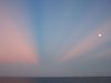
I was on a flight back in 2017 and saw the shadow of our plane as well and managed to get a shot of it.Not too long ago I was flying high above the clouds and saw a complete rainbow circle (glory) with the shadow of the plane inside of it. Too bad I didn't have any camera with me, but apparently it is a phenomenon seeing every now and then:
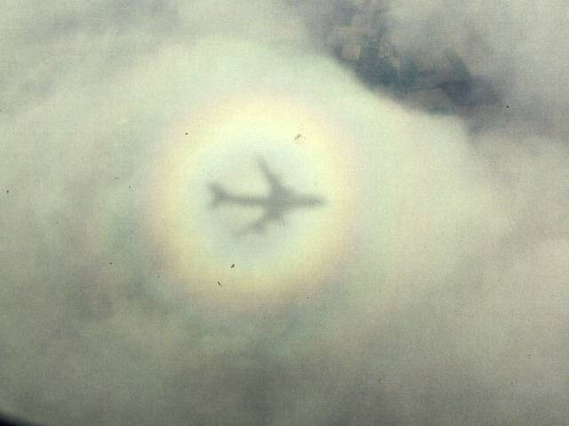
It just seemed so unreal, almost had to be 'fake'
Patrick Gonzalez
New Member
Taken today from Tijuana, I saw some nice crepuscular rays.


derwoodii
Senior Member.
last summer large fires covering 3 or more eastern state gave much Australia about 4 or months of this smoke haze. At 1st confronting after few weeks it became almost normal then New Zealand complained it was spoiling their sky & smoke smelling the washing..
oh a sky piccy ok me kayaking a local lake before covid stage 4 lock down, look an orb on my paddle
ptosis
New Member
Thanks for giving me a name to these types of clouds.some mammatus clouds over the ranch today not the dark deep good ones but well best i seen for some time
View attachment 39263
Attachments
Similar threads
- Replies
- 3
- Views
- 1K
- Replies
- 28
- Views
- 4K
- Replies
- 42
- Views
- 6K
- Replies
- 21
- Views
- 6K