CaptainBeefheart
New Member
I'm also interested in debunking this if anyone wants to help with that:
Last edited by a moderator:

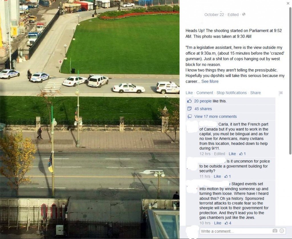
Particularly the claim that the cops were set up and ready for the shoot-out based on this photo ... apparently the Ottawa Police and RCMP should not be seen together like this... and that the shadows prove this was taken at 9:30am
Yes, the estimated shadow positions at 9:30 EDT are shown below with yellow lines (bearings 128°):Can you draw in an estimated position of the shadows at 9:30?
")
So you're admitting that the sun was in on it, too?I have drawn shadows of the three nearest lampposts on Google Earth. They give the Sun azimuth bearings of 136±1° at the time of the photo.
According to the Sun position calculation for Ottawa on 22 October, this corresponds to the time interval between 10:00 and 10:15 EDT:
So it looks like the picture has been taken after the shooting started.
Nice work, Trailspotter...But, wouldn't an actual false-flag look more professional? Wouldn't "they" make the CPR look legit rather than full of mistakes that could be "debunked" on Youtube?
heres the posting link (from above claim) that shows someone getting a 8:18 time... but using a different sunshadow tool. maybe you can try that one too and see if maybe some of these programs are flawed..would be useful info.The actual positions (shown with purple lines) have been derived with the help of distinct ground features used for reference: the zebra crossing, the brick fence posts, the road markings ('turn left' arrow sign, dark spots, etc).
heres the posting link (from above claim) that shows someone getting a 8:18 time... but using a different sunshadow tool. maybe you can try that one too and see if maybe some of these programs are flawed..would be useful info.
he used suncalc.net
note: I find NO online source for this photo other than CT type blogs and this fb thread below, she seems to be saying her source (she originally uploaded this at 10:50ish on oct 22nd) is only 'claiming' he took the photo at 9:30. no proof was given as far as I can tell from the photo taker...that I can find anyway
so its kinda a "suncalculation program war" (ie which program is right)
https://www.facebook.com/photo.php?...20610779.56929.100000354889246&type=1&theater
https://archive.today/UvFWe
The image in the video you present we discuss appears to have been made at 8:18am, Ottowa time. I haven't spent a lot of time with the SunCalc, and perhaps some daylight savings time was in effect, perhaps it is 9:18am, Ottowa time. Yes, checking Sandy Hook research data, SunCalc is ahead 1 hour, so the image you show was taken at 9:18am EST Ottowa time.
PS From the guy's comment on FB, it looks like he got it wrong by about two hours; one hour probably came from a different time zone, the other could have come from the tilt of the aerial image
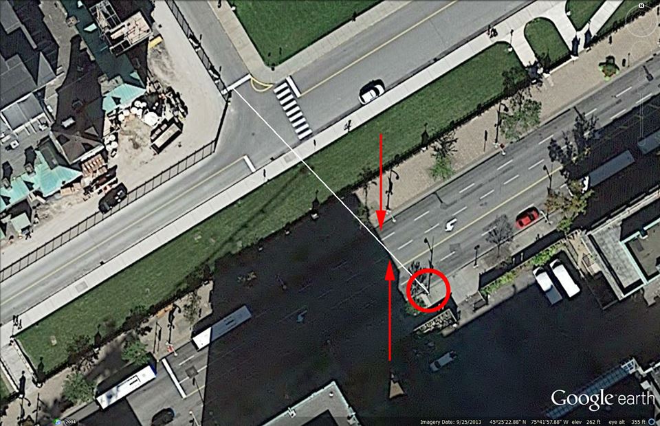
He started with Google Earth, as I did. He used the shadow from the same lamp post (one of the three I used) and got for it the same heading of 136°, as measured by GE ruler tool. This raises the question: why is his calculated time so different from my result? It can't be due to different calculation methods: people have been doing astronomical calculations for centuries and they known to be very accurate.The image attached here, (the white line in the image especially), simulates the shadow cast by the lamp post -- the base of which is on the southeast side of Wellington Street -- the shadow of that lamp post is falling across the street, towards the northwest. The two red lines indicate the points on Wellington Street where the shadow crosses Wellington Street and those points are accurate to less than one foot, less than 12 inches, which is less than 1 degree on the compass, which is accurate to within 4 minutes when using shadow direction for time of day stamp.
Those points on Wellington Street are defined the endpoint of one white street marker line and its adjacent street marker line, the starting point of the adjacent, white, street marker line.
When we go here:
http://suncalc.net/#/45.4231,-75.6994,20/2014.10.21/08:18
and then drag the circle so that the ORANGE line lays over these points, (the base of the lamp post, and then the two points on Wellington Street), (click and hold the center black spot in the center tear drop to drag the circle/orange line into place) ... we can see the time of day indicated is 8:18am, Ottowa time ... BUT ... that's an hour off, because the applet is not set for daylight savings time, the time is 9:18am, Ottowa time on the day of the event.