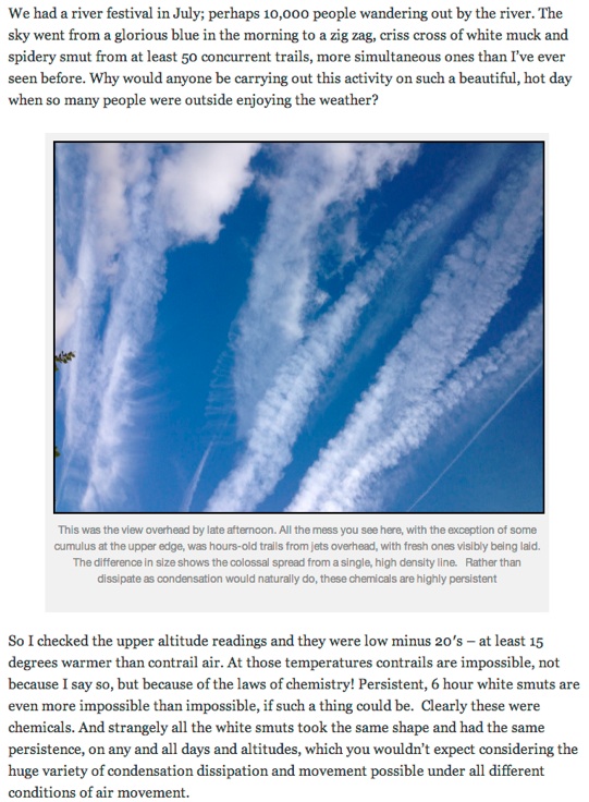
Debunked: Iain Carstairs' Chemtrail Conspiracy Theories

Jay Reynolds

Senior Member.
Iain Carstairs came to my attention as a result of this Tweet:


Iancarstairschemtrailsthreat010313.png

I wondered what could make a person issue such a statement?

Iain Carstairs is from Bedford, England, where he sometimes does artwork.

I found that Iain Carstairs claims to have only recently learned of this issue, and has written an article about chemtrails on his Blog

The purpose of this thread is to examine the factual basis and errors made by Carstairs in making his declaration:

The Reality of Chemical Spraying: peculiar air in NATO countries!
 
His base error seems to be the common misunderstanding:

Rather than dissipate as condensation would naturally do, these chemicals are highly persistent
Content from External Source
Clouds are "condensation". Hence contrails can last as long as clouds do.
 
His base error seems to be the common misunderstanding:

Rather than dissipate as condensation would naturally do, these chemicals are highly persistent
Content from External Source
Clouds are "condensation". Hence contrails can last as long as clouds do.

That might be the genesis and is definitely an acceptance of the opening gambit of the hoax, but he seems to be misunderstanding planefinder in some way.
This has convinced him that what he sees are not commercial planes. There is much more, and I see he is a truther and accepter of many other alt-beliefs, so the die is rather set. I plan to spend some time and then present the case to him for rebuttal. I'd appreciate anyone's help. See you tomorrow.
 
If you take a look at his Twitter history over the last week (26 to 28 Feb) you will see that I was discussing some chemtrail related issues with Iain (note the spelling there) and a few other silent addresses. He ended the discussion with insults so I threatened to block him because of it. He woke up to the idea and blocked me instead.
One of the silent addressees eventually picked up a conversation for a few exchanges ending with something like "I respect your views, but don't agree with them". Not sure how that works.
 
I see from his blog that he has upper air data which I've never been able to find for the UK (if anyone has that BTW I'd love the link). The observations from Nottingham he has posted in the blog are from the University of Wyoming - perhaps he has got his Nottinghams mixed up.
 
I see from his blog that he has upper air data which I've never been able to find for the UK (if anyone has that BTW I'd love the link). The observations from Nottingham he has posted in the blog are from the University of Wyoming - perhaps he has got his Nottinghams mixed up.

It is Nottingham UK. 03354 is the weather station at Watnall and part of the radiosonde network. It would appear that they feed their data into an academic network hence the University of Wyoming and I would presume openly available.
http://www.weatheronline.co.uk/reports/wxfacts/Radiosonde.htm
http://weather.gladstonefamily.net/site/03344


However his assumptions fall on their arse as he is making the statement that the trails where at 20000 ft. As the aircraft where not on ADS how can he assume that?
 
This user has also picked up the following meme, and has been ruthlessly spamming it...

#chemtrails British MP has promised to look into the matter IF he gets enough emails: richard.fuller.mp@parliament.uk
Content from External Source
I can't see where this originated, but it may be worth point Mr Fuller to the facts before these cranks waste any more of his time - http://www.richardfuller.org.uk/

UK Twitter chemtrailers are seriously on the rise, and I report those that are spamming this kind of this as a matter of course now, since that's exactly what they'll do to you if you try to engage with them.
 
It is Nottingham UK. 03354 is the weather station at Watnall and part of the radiosonde network. It would appear that they feed their data into an academic network hence the University of Wyoming and I would presume openly available.
http://www.weatheronline.co.uk/reports/wxfacts/Radiosonde.htm
http://weather.gladstonefamily.net/site/03344


However his assumptions fall on their arse as he is making the statement that the trails where at 20000 ft. As the aircraft where not on ADS how can he assume that?

Well will you look at that. You'd think this stuff would be easy to find through the Met Office.

Still doesn't explain why he shows the observations for 11 October though.
 
Iain Carstairs said:
When I’d try to match a comparative blue from the sky and found it messed up with swirling strings of white muck, I would get the planefinder app out to identify the culprit only to find not a single spray plane turned up on it. A white jet would be directly overhead, spraying away, but no commercial air traffic was present on planefinder over a 15 mile radius. I double checked with Daniels of pinkfroot and he assured me, yes, all commercial traffic, private planes etc, would be on there, in real time. All of them bar FlyBe? YES, he said.

Observation:
Iain Carstair seems to be restricting his field of view down to 15 miles. This could be making him assume that if he sees contrails, and no identifiable jet traffic shows up on http:/www.planefinder.net , the planes he sees cannot be civilian, commercial, or private planes. He does mention that the particular plane in his photo is "straight up", however.

Possible Reasons for the error:
Perhaps Carstairs needs to review Mick's page showing how to use an iphone to estimate the distance a flight is away from an observer:
http://contrailscience.com/how-far-away-is-that-contrail/
and estimating the height of a contrail:
http://contrailscience.com/measuring-the-height-of-contrails/

Observation:
He also mentions contacting the planefinder site, and claims that they told him all commercial traffic would show up, in real-time. But we know that is not exactly true:

Possible reasons for the error:
Mick West(on using planefinder.net) said:
I figured out what it was doing - it's actually interpolating the position of scheduled flights. No wonder I could not match it up to anything I could see. It's basically guessing the position of 90% of the flights based on when they were supposed to take off and land, and using straight line reckoning. You can turn it off in the options, then you just get the same planes as flightradar24, but far less than FlightAware.
https://www.metabunk.org/posts/13879

Carstairs could also smply be seeing planes which do nt carry ADS-B transceivers.


I find it rather improbable that if he made careful surveys of air traffic and used the proper resources in a proper way that he would never find an ordinary commercial plane leaving a persistent contrail.
references:
http://contrailscience.com/there-are-a-lot-of-jets-in-the-air/
http://contrailscience.com/britain-from-above-air-traffic/

Which leads me to persistence.

Observation:
He seems able to understand contrail formation theory well enough, even if he may not understand the spatial and temporal limitations of radiosonde temperature and humidity data. One thing which he also gets wrong, as Mick mentioned before, is that he seems to have no knowledge of the conditions which would make a contrail persist. He makes no mention of that subject at all, seems unaware.

Iain Carstairs said:
I started to watch them more closely, and read about the Appleman chart which shows conditions at which contrails form: this is a combination of pressure, relative humidity and temperature, all of which can vary by altitude. So I also needed, and found, a meteorological weather balloon site supplying these readings at all altitudes over Nottingham thus giving a very good idea of conditions over this area. Even on the hottest days of the year, the sky was STILL criss-crossed with this weird, solid white muck from planes. The white would turn to spidery trails which congealed with others to form a dull white mist over the entire sky. If this was condensation, it was a radical and stubborn new form of it.

Possible reasons for the error:
Carstairs may be getting all of his information from chemtral believer sites. Most of them either accept outright the myth that contrails cannot persist, and very few go anywhere past that point describing the reasons why they make that claim, because doing so ends the premise of "chemtrails" (any persistence is impossible).
The following references should be helpful in clearing up that misunderstanding:

http://contrailscience.com/persisting-and-spreading-contrails/
http://contrailscience.com/contrails-are-condensation-but-not-like-your-breath/
http://contrailscience.com/1980-nbc-news-report-on-contrails/
http://contrailscience.com/why-do-some-planes-leave-long-trails-but-others-dont/
http://contrailscience.com/why-planes-make-vapor-trails/
http://contrailscience.com/ground-level-contrails/

Observation:
Iain Carstairs said:
Knowing the altitude of BA and AF jets from planefinder’s readouts to be 30,000 feet (9144 metres) and that they look roughly a third the size of spray jets and seem to move at a much slower speed relative to the ground, the spray planes must be operating much lower, perhaps around 20,000 feet, which on the day in question, had a temparature of -20.7C.

Possible reasons for the error:
I note that Carstairs mentions only European airlines which are generally more likely to have ADS-B transceivers installed. This lends further credence to the possibility that the flights he is unable to identify might be US flag or other carriers not using ADS-B. Reagrding his use of the 20,000 ft baseline for formation temps, ince there is so much traffic over the UK, to believe that he is observing 50 or more "sprayplanes" flying 10,000 feet below enroute commercial traffic over the course of six hours beggars belief.
 
Last edited by a moderator:
Still doesn't explain why he shows the observations for 11 October though.

Observation:
So, he shows a photo of persistent contails on a date in July, but shows upper air data from October 11, that is the date of his first photo of the jet, which does not have a later photo showing whether it persisted or not, and it is the October 11 plane shot which he says was unidentifiable using planefinder.net.

Suggestion for improvement:
He needs to be a little more detail oriented to make his points. To more completel document the events, he should be doing all three, photograph formation, photograph persistence/non-persistence, and identified/not indentfiable.

Perhaps at the times he had not developed the skills needed to do these things, but by now he seems able. So, while he hasn't yet gotten it all together and been able to make a complete comprehensive presentation, he has jumped to some conclusions and is advocating buying/selling heat seeking missiles and shooting down planes......... Rather hasty pudding, even for Nottingham!
 
He does seem to be confusing his dates (at least from the reader's perspective), I suspect the photo below is not from The July Bedford River Festival (July 21 and 22, 2012):


Seems like typical July Weather back then on the first day

http://www.flickr.com/photos/rob_anderson_uk/7615202090/


More haze developing later
http://www.flickr.com/photos/steven_9709/7621387048/


Don't see any persistent contrails though, just high hazy cloud.


The next day was similar:
http://www.flickr.com/photos/56063595@N02/7636206096/


MODIS for that day shows the combination of low puffy cumulus (the brighter white speckles) and hazy high cirrostratus. Not much in the way of contrails, nor do I see many contrails in the tourist photos of the Festival

http://earthdata.nasa.gov/labs/worl...nd&time=2012-07-21T12:00:00&switch=geographic

You can see very clearly from the scale of the band of haze that it's the haze (upper air humidity) creating the contrails, not the other way around.


The Aqua image shows the contrails in the cirrus haze band, as the weather moves east they (and these conditions) would have arrived in in Bedford around Noon. Nothing at all special about bedford though. Then entire country would have the same conditions.
http://earthdata.nasa.gov/labs/worl...nd&time=2012-07-21T12:00:00&switch=geographic


Zooming out gives perspective on where the moisture is coming from


Next day:


http://earthdata.nasa.gov/labs/worl...nd&time=2012-07-22T12:00:00&switch=geographic
 
Last edited:
I came across a blog on Chemtrail Planet posted on the 10th October which provides a link to the Nottingham data at Wyoming. Interesting that Iain then produces a blog nearly identical with data from the.next day
http://chemtrailsplanet.net/2012/10...-are-actually-aerosols-of-chemical-pollution/

The University of Wyoming database is searchable and a quick Google search tells me the dates in July possibly the 21st or 22nd so the actual data for Nottingham is at this link
http://weather.uwyo.edu/cgi-bin/sou...AR=2012&MONTH=07&FROM=2100&TO=2300&STNM=03354
 
Thanks Dave, I was just going to look that up:

The link you gave was for 00Z, midnight GMT, you'd really need the 12Z soundings, but they don't seem to be one for Nottingham. There is for Valentia in Ireland, which would basically be Bedford later that afternoon:

http://weather.uwyo.edu/cgi-bin/sou...AR=2012&MONTH=07&FROM=2112&TO=2112&STNM=03953


-----------------------------------------------------------------------------
PRES HGHT TEMP DWPT RELH MIXR DRCT SKNT THTA THTE THTV
hPa m C C % g/kg deg knot K K K
-----------------------------------------------------------------------------
700.0 3133 2.2 -8.8 44 2.82 295 19 304.9 313.9 305.4
699.0 3145 2.2 -7.9 47 3.03 295 19 305.0 314.6 305.6
692.0 3226 2.0 -1.5 78 4.98 295 19 305.7 321.2 306.6
620.0 4103 -4.0 -5.0 94 4.29 290 17 308.5 322.1 309.3
615.0 4167 -4.5 -5.2 95 4.24 296 19 308.7 322.1 309.5
602.0 4336 -2.6 -7.9 67 3.53 310 21 312.7 324.2 313.4
597.0 4402 -1.9 -8.9 59 3.28 309 25 314.3 325.1 314.9
590.0 4496 -2.5 -10.5 54 2.93 307 29 314.7 324.4 315.2
585.0 4564 -2.3 -16.3 33 1.84 305 32 315.7 322.0 316.0
584.0 4577 -2.4 -16.2 34 1.86 305 33 315.7 322.1 316.1
558.0 4937 -5.3 -13.3 53 2.47 309 35 316.4 324.8 316.9
551.0 5036 -5.1 -29.1 13 0.63 311 35 317.8 320.1 317.9
533.0 5295 -7.1 -17.1 45 1.89 314 36 318.4 325.0 318.8
515.0 5562 -9.3 -23.3 31 1.14 317 38 318.9 323.0 319.1
503.0 5744 -10.3 -13.6 77 2.68 319 39 319.9 329.0 320.4
500.0 5790 -10.7 -13.7 79 2.67 320 39 319.9 329.0 320.4
491.0 5930 -11.9 -14.1 84 2.63 321 39 320.1 329.1 320.6
483.0 6056 -11.1 -17.1 61 2.08 322 39 322.6 329.9 323.0
441.0 6750 -16.7 -20.1 75 1.77 327 40 324.0 330.3 324.4
413.0 7241 -19.0 -24.8 60 1.25 330 41 327.2 331.8 327.5
400.0 7480 -20.1 -27.1 54 1.04 325 45 328.8 332.6 329.0
389.0 7687 -20.9 -28.9 49 0.91 323 45 330.4 333.8 330.5
350.0 8459 -26.9 -36.9 38 0.46 316 46 332.4 334.2 332.5
346.0 8540 -27.6 -37.1 40 0.46 315 47 332.5 334.3 332.6
311.0 9299 -34.3 -38.7 64 0.43 322 50 333.5 335.2 333.6
303.0 9481 -35.5 -44.5 39 0.24 324 50 334.3 335.3 334.3
300.0 9550 -36.1 -45.1 39 0.23 325 51 334.4 335.3 334.4
291.0 9759 -37.9 -47.9 34 0.17 330 56 334.8 335.5 334.8
282.0 9974 -39.7 -50.7 30 0.13 335 52 335.2 335.7 335.2
273.0 10192 -41.7 -51.9 32 0.12 340 47 335.4 335.9 335.4
260.0 10520 -44.7 -53.7 36 0.10 340 51 335.7 336.1 335.7
250.0 10780 -46.7 -56.7 31 0.07 340 54 336.5 336.8 336.5
223.0 11532 -52.1 -62.1 29 0.04 343 59 339.4 339.6 339.4
200.0 12230 -58.1 -65.1 40 0.03 345 64 340.6 340.7 340.6
189.0 12583 -61.1 -66.1 51 0.03 342 68 341.3 341.4 341.3
184.0 12747 -62.0 -67.4 48 0.02 340 70 342.4 342.5 342.4
165.0 13415 -65.9 -72.9 37 0.01 330 66 346.8 346.9 346.8
164.0 13452 -65.6 -73.3 33 0.01 330 68 348.0 348.0 348.0
159.0 13642 -63.8 -75.1 20 0.01 340 68 354.0 354.1 354.0
150.0 14000 -60.5 -78.5 8 0.01 340 58 365.6 365.7 365.6
140.0 14431 -58.1 -85.2 2 0.00 335 39 377.1 377.1 377.1
139.0 14476 -57.9 -85.9 2 0.00 332 39 378.3 378.3 378.3
135.0 14660 -57.9 -86.2 2 0.00 320 39 381.5 381.5 381.5
125.0 15145 -57.7 -87.0 1 0.00 340 35 390.3 390.3 390.3
120.0 15402 -57.6 -87.4 1 0.00 320 33 395.0 395.0 395.0
100.0 16550 -57.3 -89.3 1 0.00 335 27 416.7 416.8 416.7
89.0 17292 -56.4 -88.7 1 0.00 340 21 432.7 432.7 432.7
Content from External Source
It shows plenty of upper air humidity, unfortunately the upper air humidity figures for most radiosondes tend to the low side, and often don't work at all, as seen by the abrupt drop around 14,000m. But the basic picture is not inconsistent with the visual observations.

There's a technical discussion of the Radiosonde problems here:
https://www.metabunk.org/threads/75...de-humidity-soundings-for-contrail-prediction
 
Last edited:
Sorry about that. I did not read the full data set and presumed 12Z would be there. I am new to atmospherics but it makes sense for Nottingham not to be chucking a balloon up in the air on a relatively busy flight path during the day.
 
I don't think flight density in time and space is a consideration of how often to schedule these radiosonde flights. They are quite expensive to run as none of the materials and equipment that are flown are reusable. Some stations, and Nottingham, must be one, only do one flight per day.

To work out which station can go to one flight per day, there is testing done with the atmospheric analysis phase of the modelling to gauge the effect on the analysis quality on omitting flights from various combinations of stations. For instance, it was found that, provided the Bureau of Meteorology (Australia) continued their radiosonde program on MacQuarie Island, New Zealand could cease the upper air program completely at Campbell Island. This is in the Southern Ocean, south of Tasman Sea and New Zealand. It did not work as effectively the other way round, drop MacQuarie and keep Campbell, so New Zealand became the lucky country.

Having looked at the upper air data over the UK to diagnose for persistent contrails, I was surprised that there are so few upper air stations in the British Isles area. I am sure they have done their sums and arrived at an optimal program. Too bad for us. Another way to go would be to use the NCEP Reanalysis data available 6 hourly. However is is not as accessible to the general public, and it would take a considerable amount of downloaded data and computation and know-how to reproduce a single sounding for any given time and location. The advantage is that you are not limited to observation stations or their flight schedule. You can go anywhere at 6 hour steps.

I concur with Mick in his conclusion about what the data on that particular day conveys.
 
Observation:
While it is clear that Iain Carstairs has quite a few misunderstandings and even a lack of understanding about the subject of ordinary contrails, on closer examination of his article I came across this:

Iain Carstairs said:
Be all that as it may, at a recent conference on geoengineering Keith welcomes further oprobium on the heads of micro-focused scientists by exposing his own – far from uncharacteristic – reckless personality. When questioned about the morality of dumping ten million tons of aluminum patricles into the stratosphere without having done any toxicology studies, and without bothering to read the ones already done which reveal that 10 micron particles of aluminum are extremely dangerous to human health, he grinned and shrugged:

“I don’t see it as a moral issue.. it’s more like freeriding on our grandkids.”

I’ve been in touch with Ken Caldeira and David Keith and they have nothing to say about chemtrails at all: they say their geoengineering would look more diffused, being at higher altitudes, and they swear it isn’t them. Like many intellectuals, they live in a bubble, think in a bubble, work in a bubble, and focus on whatever is on the tip of their nose: unconcerned about the sensibilities of people who see something seriously amiss in the skies – and failing to see that whether responsible or not, the inevitable exposé will wreck their own credibility – they casually waft away the danger posed by injecting 10 megatons of 10 micron particles into our lungs. After all, what interests them is the science. Now, that is fascinating. All else, including the devastation of the planet on which they live, is a trifle of no concern.

Reality:
Searching for the quote which Carstairs claims is from the University of Calgary's Dr. David Keith, the only website on earth using that specific wording for such a quote turns out to be Iain Carstairs' site:
Search using "I don't see it as a moral issue.... "David Keith"

What to make of this? Is it possible that Carstairs is misquoting Keith for some reason?

Yes! Carstairs has not only quoted Keith in a context completely different from the one where Keith actually used a similar quote, he is doing so while also misquoting the words he actually used.

Consider the context which Carstairs puts this quote into play. He says that Keith was being questioned about the morality of geoengineering, that he mentioned having done no toxicology studies, and just "grinned and shrugged" before he made the quoted statement.

That is simply a totally false portrayal of not only the context of the event, not only the verbal context surrounding the quote, but even Carstair's description of Keith as having "grinned and shrugged" is incorrect. All of these are complete fabrications! Carstairs just made them up. He lied.

In an effort to show the correct context, meaning, and even a direct response from Keith about the quote, you should refer to Mick West's previous work on this subject: Debunked: "Geoengineering is like free-riding on our Grandkids"

First, the correct verbal context of the quote. David Keith is standing at a podium speaking to a room of people, he is not answering questions about toxicology.

He says:
The more we do research, the less easy this will look, the more complicated the environmental effects will look. And that's a good thing, because right now it looks too easy. So I think that if we do more research we're likely to find out that it's harder and more complicated than we thought, and that the side effects are harder to manage. And that's a healthy outcome that will make it easier to do the management(?). Of course, the opposite reaction is possible. It's an empirical question how people will react to knowledge about this. Another reaction is to say "if these crazy scientists are SO concerned about putting CO2 in the atmosphere that they want to think about these things, then that might mean actually mean we should be more serious about the risks of CO2 in the atmosphere".

And by the way, it's not really a moral hazard, it's more like free riding on our grandkids.

You can see Keith make the quote right here on video.

As you can see, Iain Carstairs has not only divorced the quote from it's context, he has deliberately replaced the context by changing it to one in which Keith is being questioned from one in which he is simply giving a talk to an audience. Carstairs also changed the quote by deleting the "And by the way, it's not really a moral hazard" into, "I don't see it as a moral hazard".

Quoting out of context could possibly be understood if the comment was difficult to understand. As Mick's research in the link above showed, the specific wording Keith used ("moral hazard")is somewhat arcane unless you are familiar with economic or casualty insurance matters.

But Carstairs has taken an out-of-context quote to a whole new level by changing the situational context as well as re-wording the actual quote.

I cannot see any excuse for such a deliberate set of changes. It is clear that this was a conscious act meant to persuade by deception.

Suggestion for improvement:

Iain Carstairs needs to carefully examine his personal moral compass and ask himself why he did that to Keith. He should remove the quote altogether since in context it does his case no good at all, and he should directly apologize to David Keith.
 
Last edited by a moderator:
My name is Iain Carstairs. My point is very simple, and to date, none of the shills on twitter or FB or anywhere else have been able to answer it, so it cannot be debunked until it has been addressed.

Get a copy of planefinder - it's a couple of dollars, no more, and run it on your iphone. or run it on your PC for free. When you see a plane spraying overhead you loko at planefinder. Here in Bedford there is very little overhead traffic - but what planes can be found on ADS-B radar systems do not leave any contrails, or if they do, they are very small and disappear very quickly.

However. When you see a jet piling out a huge load of white muck - which is very annoying to see - you cannot find this plane on planefinder. It simply isn't there. This means the plane is non ADS-B which means military.

Now I'm not saying what they are and are not spraying. I'm saying, these are not CAA planes. My contact at the CAA, Mark Simmons (my company runs a database of commercial flights and the CAA know us well) assures me no civil aircraft have been retrofitted for any kind of sprays. And my observations confirm that. He hinted that the only ones possibly responsible would be the MoD. Now since the spray planes don't appear on ADS-B and are flying in the same air (and at a lower altitude by the looks of them) and are using the same engines and fuel, they should all be leaving the same contrails or none at all.

Nobody in the debunk business seems interested in asking or answering these questions. If people would rather deny something that is clearly happening, then that is their problem. But after having refused to ask or answer these questions, they have no right to set themselves up as debunkers. They are just people who can't be bothered.


Iain Carstairs came to my attention as a result of this Tweet:


Iancarstairschemtrailsthreat010313.png

I wondered what could make a person issue such a statement?

Iain Carstairs is frm Bedford, England, where he sometimes does artwork.

I found that Iain Carstairs claims to have only recently learned of this issue, and has written an article about chemtrails on his Blog

The purpose of this thread is to examine the factual basis and errors made by Carstairs in making his declaration:

The Reality of Chemical Spraying: peculiar air in NATO countries!
 
I have a question which none of the shills - people on twitter who have only posted "debunk" info about chemtrails in the two years they have been on twitter - have ever been able to answer.

None of the spray planes show up on planefinder. The planes which DO show up - don't leave any trails at all. The ones who do NOT show up - leave massive white muck across the sky. Since ADS-B is civilian radar and every CAA craft carries it - why should non-ADS-B craft leave huge persistent trails, and civilian aircraft, none?

The moment this question is answered a great deal of the anger about chemtrails will then have an outlet for investigation. perhaps military planes are designed to give away their direction and journey for all to see, to give the enemy a fair chance? since nobody answers these simple questions, the suspicions persist. there is no point poking fun at the questioners if you don't intend to answer their questions.
 
Ross, I checked over your entire twitter history and the whole thing was pro-chemtrails, bar a few random tweets which started on 29 May 2009.

I ended up blocking you only when I realised you were shilling for this chemtrail crap. Now, nobody really knows what they are spraying, or even why; but what we now know is that spray planes don't turn up on commercial tracking systems.

My company runs a database of commercial flights, and so I have had contacts in the CAA. Only after getting planefinder software did I realise none of the spray planes were civil aircraft. You can verify this for yourself - as can anyone else - but none of the "debunkers" ever go to this trouble.

So while at first it seems that debunkers are just people who love to argue, when you realise they don't want to answer hard questions or make observations of their own, you quickly realise you are wasting your time. I blocked you because it's a colossal headache dealing with shills. Deraling with reasonable doubters is easy - get them a copy of planefinder, let them make their own observations.

Anyone complaining about chemtrails has a right to do so if they have the evidence of their own eyes. But a shill is someone who is clearly incapable of doing what they purport to do: they do not debunk, they just deny. But they deny without any proper investigation. Planefinder is a couple of bucks, and if you live in NATO country you only have to wait for a clear day to see a spray plane starting out in the morning - and so if you wanted to, you can verify exactly what I have been saying.
 
I am Iain Carstairs and I know a little about contrails, having worked in the aviation business since 1983! I also went to the trouble of referencing weather balloon data on the days I was complaining about, and matched them with the Appleman chart.

As far as David Keith goes, I have been in email contact with him last year; he says his geoengineering would be higher and more diffuse. But the quote is accurate, and you can find it on YouTube actually coming out of Keith's mouth. So I suggest if you're going to take me apart on your website, check your sources, check your facts.

https://www.youtube.com/watch?v=nmGRy_cCiZw

This is a recording of David Keith. His exact phrase is as follows and can be found at 3:52.

"And by the way, it's not really a moral hazard.. it's more like freeriding on our grandkids."
 
Because I noted the comparative known altitudes of ADS-B craft, 30,000 feet, and saw with my own eyes that the spray day planes were a lot lower, and travelling at an apparently greater velocity. I simply estimated their altitude, as I believe I explained in my post.

What is never dealt with by the shills is why these white-muck planes don't turn up on ADS-B. They can't all be FlyBe - zooming back and forth in a grid.
 
What I can tell you from my own experience, is that looking up and seeing a beautiful blue sky reduced to a criss cross of wispy white muck - all coming out the back of jets (having been outside the whole day observing it) is an unsettling experience. Your first reaction is curiosity - then you look into it and find that they are NOT civil aviation planes (as can be verified by anyone with access to a PC or iPhone) and so you naturally start making enquiries.

When you reach the point at which you no longer see blue skies at all, and you already know these are non CAA aircraft (just ask Mark Simmons at the CAA, with whom I have been corresponding) and then you get told by David Keith and Ken Caldeira themselves (both of whom have corresponded directly with me last October) that it isn't their geoengineering - that's when you start getting angry. And the shills keep bleating, "it's persistent condensation." On the hottest day of the year? And the coldest? In winter and summer? In morning, noon and evening? In all wind conditions? It's impossible.

This anger is a normal, understandable and quite predictable effect. If someone were to just once explain that these military planes were simply conducting radar chaff experiments, or harmless cloud seeding, or more Porton Down or US Radium experiments, at least this anger would be directed and focused at the relevant authorities, who would be obliged to explain themselves or advise when they are carrying out such tests. The anger would be converted into meaningful activities and energy.

Without any such explanation, and with utter dolts saying "oh, it's all condensation" - when, on the same days, CAA craft overhead do NOT leave the same white turds over the sky - people get very angry indeed, and so they damn well should. And this reaction should have been predicted a long time ago. Feigning sorrowful despair now at people expressing normal reactions shows an appalling lack of understanding of human nature.

There are similar sites condemning 911 truth activists - forgetting completely that more than 2000 professional engineers are already expressing contempt for a bogus government story. With all this sham "shill" activity going on, you have to expect people to be angry and suspicious; and when it sinks in that these are military craft, it's going to get a lot worse.
 
I am Iain Carstairs and I know a little about contrails, having worked in the aviation business since 1983! I also went to the trouble of referencing weather balloon data on the days I was complaining about, and matched them with the Appleman chart.

As far as David Keith goes, I have been in email contact with him last year; he says his geoengineering would be higher and more diffuse. But the quote is accurate, and you can find it on YouTube actually coming out of Keith's mouth. So I suggest if you're going to take me apart on your website, check your sources, check your facts.

https://www.youtube.com/watch?v=nmGRy_cCiZw

This is a recording of David Keith. His exact phrase is as follows and can be found at 3:52.

"And by the way, it's not really a moral hazard.. it's more like freeriding on our grandkids."

But that's not what you quoted is it? And you imply this means he somehow does not care, and he is is being reckless. You also imply he's talking about toxicology. The exact opposite is true. Keith is very much AGAINST freeriding on our grandkids. And he was talking about climate change, not toxicology. I emailed him about this quote and he said:

On “Moral Hazard”, this is a technical point for economists. when you think carefully about the definition its clear that’s quite the right way to describe SRM, “free riding” another econ term that more accurately describes what we are doing when we don’t cut CO2 emissions. To be clear, I do mean “putting off addressing the problem of climate change is like free-riding on our grandkids”. It’s not that SRM is free riding, it’s that over enthusiasm about its potential may encourage less action to cut emissions.
Content from External Source
David Keith has gone to great lengths to explain that there's no covert geoengineering going on, and that he's absolutely opposed to any such thing.
 
Because I noted the comparative known altitudes of ADS-B craft, 30,000 feet, and saw with my own eyes that the spray day planes were a lot lower, and travelling at an apparently greater velocity. I simply estimated their altitude, as I believe I explained in my post.

What is never dealt with by the shills is why these white-muck planes don't turn up on ADS-B. They can't all be FlyBe - zooming back and forth in a grid.

They don't show up because you are under-estimating their proximity. Planes with contrails are visible at a much greater distance than planes without. And since they are further away they are closer to the horizon, and so you are thinking they are lower.

Really what you are seeing is planes that are further away, but still at the same 30,000+ feet altitude. You need to account for that when looking on Planefinder.

I've observed planes leaving persistent contrail over Los Angeles, and I've had no problem identifying the planes as commercial. Other people have done similarly in the UK.

I suggest you attempt to photograph the planes to verify your claims. And try to account for the wider range of distances. I strongly recommend you look at the following page Jay point you towards, as it seems to be key to your misunderstanding.

http://contrailscience.com/how-far-away-is-that-contrail/
 
There's also the fact that not all commercial planes have ADS-B transmitters yet. Full implementation isn't required in the US until 2020.
 
Wait a minute, the planes I was talking about, which I observed almost directly over my own head, which I located on planefinder and compared to the headings I saw with my own eyes, were CAA aircraft. The aircraft were visible to the eye, because I could see them. They left no trail at all. In fact this is common - the jets are discernable against the blue background, but there is no trail visible at all. It's often pointed out that they are in different air. But planefinder shows them at 30,000 feet, so aircraft which seem a lot bigger and seem to cover more ground a lot faster, must be lower to the ground.

The planefinder application which I am looking at right now shows a 25 mile radius around the centre of town east, west and north, and 40 miles to london to the south. There is a Ryan Air FR3173 proceeding north west of me now, and Ezy Jet U22158 to the south, heading west. Both show up on planefinder.

So if an aircraft is visible to me in the sky, which would be no more than about a 10 mile radius, I would see it on planefinder and with my own eyes. Thus easily locating the carrier and so on, and easily verifying as to the ABSENCE of any trail whatsoever. It's impossible to photograph them because to the iPhone camera they are virtually invisible. To the human eye, which is much more sensitive - detecting even a single photon of light and equipped with contextual recognition software - the plane is just visible at 30,000 feet, but will not show up on my iPhone camera, which can only enhance the overall brightness, tending to obscure small details. I would submit the picture and you would say, "it's an empty sky."

The white muck aircraft though, generally start just to the south of bedford around 06:30 - visible in the air as being over cardington about 4 miles south, and they zig zag east and west. Visible to the eye, not visible on planefinder. Later they then go north and south, directly over the centre of town, only a mile or two either side at most, cutting long, straggly white turds in the air, which hang around, disperse into filaments (not dispersing equally) and in short order, obscure the sunlight, which is now diffused almost everywhere, but obscured where the trails are freshly laid and still relatively dense. The planes seem to spray in pairs, but I don't know why this should be.

Why are they not visible on planefinder? Because they do not have ADS-B equipment, and are therefore not CAA monitored craft. This simple claim is never once examined by the shills, but I don't understand why. It's easily verifiable in any area where there is usually heavy spraying, and judging by the vast number of people observing the heavy sprays, is just about everywhere. If you live in a no-spray area, let me know where it is - because I would very much like to move there!
 
Well you say that, but look at the planefinder screen right now over the NE seaboard
planefinder.jpg
including New York, and you can see for yourself the vast number of carriers which DO use it. Therefore, it's a very effective way of locating planes and comparing them to the "spray day" planes in their behaviour and trails. This really isn't complicated; anyone with about $2 can get planefinder and they will see most, if not all, commercial flights represented. The only one I know about not on ADS-B in the UK is FlyBe, a shorthaul op whose routes we know about anyway.
 
And if you think it's too confusing, all you need to do is zoom onto an area where you live and you find the planes are very easily distinguished. The arrow is where I am right now. There are no planes overhead at all.
planefnider 3.jpg
 
Iain, we're very aware of planefinder (and other similar services). And many people - including chemtrails believers - have been (with some practice) using these services to identify planes leaving trails, and finding that they are generally commercial aircraft. Some of these are very vocal about it, such as peekay22 on YouTube. We here are advocates of using such systems and have discussed them quite a bit (see here for example).

If I'm reading your post right, I think that Mick is right - you seem to be greatly underestimating the distances involved, if you think that planes must be within "no more than about a 10 mile radius" if they are visible - in fact, a trail being seen low to the horizon could well be 60 miles away or more. Again, highly recommend that you read: http://contrailscience.com/how-far-away-is-that-contrail/
 
Last edited by a moderator:
If you'd like to check weather balloon data, you can explain to me why, on the hottest day of the year (up to that date) August 16th 2012, the following mess was observed at around 1:00 pm, the hottest part of the day itself, directly over London; over Covent Garden in fact. Now, I lived in London from Oct 1978 until Dec 1992 and I never once saw anything like this, winter, summer, autumn spring. If even a single plane had left marks like this, people would have been very alarmed.

At around 9000m the temp was -42 and pressure 314, with 37% relative humidity. The appleman chart says contrails are not likely under those conditions, but we watched as these things drenched the sky in short order. If you like your skies this way, then you're quite right to shout down anyone who complains. But if, like hundreds of thousands of sane people, you like a blue sky every now and again, you're going to be saying - WTF?!

one hour in london on august 16 2012.jpg
 
I'm glad to hear a more moderate voice on this blog. I only really report on planes which I can see more or less directly overhead. If they're dumping stuff way to the south it doesn't affect me until it blows over later in the day, and I notice they try and keep a low profile in the mornings. I wouldn't claim to pinpoint a plane's GPS with my eye, but let's face it, over my house is over my house. Over just 2 or 3 degrees to the left is near as damnit overhead. Looking up is not the same as looking at a 15 degree angle.

I was at the school the other day, which is on a big hill. And I was talking with one of the parents, a pilot actually, and we saw a plane go directly overhead. Straight overhead, laying a creamy white mess right from as far as you could see down south to, as I say, directly over our heads. He didn't notice it at first, and we continued talking.

But I pointed it out to him, and he watched it go, and he paused. "Yes, you're right - they're definitely spraying something," he said. "No question.. but I'm sure it's nothing serious."

All we want to know is, what are they spraying? I have better things to do than enage in these discussions. Some people clearly love to argue - I don't. I want to know, what are they spraying, and under whose authority? That is all I want to know.
 
Here's two consecutive days - well, the photo speaks for itself. By all means check Nottingham weather balloon stats and satisfy yourself that contrails should not have been forming on either day. One was a beautiful day, and the other - well, if you like these skies, then you're welcome to them. I can't stand it
two day comparison.jpg
 
I'm glad to hear a more moderate voice on this blog. I only really report on planes which I can see more or less directly overhead. If they're dumping stuff way to the south it doesn't affect me until it blows over later in the day, and I notice they try and keep a low profile in the mornings. I wouldn't claim to pinpoint a plane's GPS with my eye, but let's face it, over my house is over my house. Over just 2 or 3 degrees to the left is near as damnit overhead. Looking up is not the same as looking at a 15 degree angle.

I was at the school the other day, which is on a big hill. And I was talking with one of the parents, a pilot actually, and we saw a plane go directly overhead. Straight overhead, laying a creamy white mess right from as far as you could see down south to, as I say, directly over our heads. He didn't notice it at first, and we continued talking.

But I pointed it out to him, and he watched it go, and he paused. "Yes, you're right - they're definitely spraying something," he said. "No question.. but I'm sure it's nothing serious."

All we want to know is, what are they spraying? I have better things to do than enage in these discussions. Some people clearly love to argue - I don't. I want to know, what are they spraying, and under whose authority? That is all I want to know.

Iain, please use the 'reply with quote' function of this forum. It makes it much easier to follow your arguments.
 
Perfectly normal reaction when people feel they are being attacked, I think. I've felt the same, and hundreds of others likewise. You think condensation can do achieve this? Check this out and see if you would feel angry, trying to get some blue sky on a day off that week. The planes were directly overhead, as you can see. Temperature was a non contrail day - check weather balloon data yourself. These were some of the last of the good weather of the whole year.


two day comparison.jpg
 
Iain, I'm a little confused. Are you in Bedford, UK or Nottingham, UK?

I may have missed something in the initial posts, as I'm reading on my phone.
 

I have attached a photo of a Boeing E3 AWACS aircraft which circled over the Vale of Pickering for a considerable period of time on 09/01/2013. Something is being sprayed from the wingtips which leaves persistent trails whereas no trails are being left by any of the four engines. I have witnessed similar events on two separate occasions, one lasted for approximately four hours. I wrote to the Defence Secretary and the Ministry of Defence over a month ago asking for an explanation but so far have not received any replies. I have a collection of photographs of other aircraft involved in Stratospheric Aerosol Injection here. http://ftwild2013.imgur.com

This photo shows two aircraft passing at similar altitudes taken on 02/03/2013 in North Yorkshire. Granted there is a slight difference in height between the two planes but I doubt that it is enough for one to be leaving a long persistent trail and the other not to leave a trail at all. It is also a matter of concern to me that aircraft are passing at such close quarters.

This photo was taken on 27/01/2013 and shows an aircraft following closely behind another one. These aircraft may look like ordinary airliners but if they were their flight paths would be shown on this website http://www.flightradar24.com/ . Hardly any of the aircraft that I see leaving long trails that gradually spread out to form thin cloud appear on this website. This indicates to me that these aircraft are being operated by the military. As in this photo they often fly in close formation which I believe would be illegal for commercial airlines. I think the required separation distances are 1000ft vertical and three miles horizontal to avoid backwash from the engines.
View attachment 1873
For anyone that has doubts about whether geoengineering is taking place on a massive scale now the best course of action is to watch the skies over a period of time, preferably with binoculars and to study the flight paths of commercial airlines using a website like http://www.flightradar24.com/. There is no need to listen to people who profess to be experts because the difference between a normal condensation trail from a known flight like this and chemtrails like this will soon become apparent.

The chances are that aircraft flying strange courses leaving criss cross trails across the sky are involved in stratospheric aerosol injection and are not commercial flights.

[ADMIN: Sorry I deleted the dupe of this post, and it deleted the images you uploaded, I'll try to find them in your imgur page, let me know if they are incorrect]
 
Last edited by a moderator:
I'm in Bedford, UK. There is no direct weather balloon data for Bedford but Nottingham, UK, is quite close, and representative. There are other samples to the south so a good idea can be had. But when the day is so hot people are hiding in the shade and wandering around topless, it's also pretty convincing evidence!

stratosphere anomalies.gif

This graph shows anomalies in lower stratospheric temperature; the area starts at 30,000 feet so it applies to the mass transit altitude we're discussing. The anomalies are not so important, but what it shows is a gradual warming trend. The chart shows other observations related to conflicts within the popular global warming model, which is not the aim of this thread.

But since mean temperatures are generally increasing, the likelihood of contrails should be less, certainly in commercial traffic. Although as an adult I lived in Londeon from 78 - 92, from 1958 - 1968 I lived in Wimbledon, on the flight path to Heathrow, where planes sometimes showed small contrails. What I notice these days is that CAA craft almost never show contrails. Occasionally they do, on very cold days, and these dissipate and vanish completely, in an even and consistent manner, as soon as they appear. About 10-15 seconds is all that is needed.

These planes on planefinder show altitudes of around 30,000 feet as we are presently well away from airports, and on flight routes of transatlantic carriers headed, for example from JFK to Schiphol. These planes absolutely never leave trails. Planefinder is constantly on, and when a/c routes overhead are visible from the vicinity of where I work, the planes are barely visible, as tiny silver-white objects. Without trails.

And then.. hey presto! A non CAA craft comes along spraying white muck like there is no tomorrow. So from the point of view of someone who watches the skies, who is interested in the skies, whose clients all have dozens of aircraft in the skies at any one time - it's perfectly obvious something is happening. All we want to know is, what?
 
Back
Top