
You are using an out of date browser. It may not display this or other websites correctly.
You should upgrade or use an alternative browser.
You should upgrade or use an alternative browser.
Debunked: Exploration company "Georesonance" believes it may have found MH370
- Thread starter derwoodii
- Start date
David Coulter
Senior Member.
New GeoResonance press release:
http://georesonance.com/20140630 Press Release.pdf
They raise a couple of interesting points and state that it has been confirmed that their location has not been searched.
The arguments from this company are circular. The "confirmation" that their location has not been searched is that nothing has been found, therefore the correct location was not searched, QED. Same arguments about the Armenia. Bangladesh did a search of the exact location (a poor country, but I assume their navy at least has a handheld GPS that would put them within 3m of the target). What would be the motivation to deploy search vessels and intentionally avoid the target?
These press releases have devolved into rants. Why haven't they acquired additional imagery and run more analyses, then put out a press release showing new results?
vooke
Active Member
New GeoResonance press release:
http://georesonance.com/20140630 Press Release.pdf
They raise a couple of interesting points and state that it has been confirmed that their location has not been searched.
GeoResonance is actually more believable than all the authorities combined
Why can't any of the search/investigation country demand for more data?
David Coulter
Senior Member.
GeoResonance is actually more believable than all the authorities combined
Why can't any of the search/investigation country demand for more data?
No, they are not believable. But they are very good at sounding believable. Have a watch of the British show Hustle to see how these types work. Unfortunately for Georesonance, CNN published a very supportive story about their claims which got a whole bunch of scientists upset. That is pretty much what started this thread.
bume
Member
The arguments from this company are circular. The "confirmation" that their location has not been searched is that nothing has been found, therefore the correct location was not searched, QED. Same arguments about the Armenia. Bangladesh did a search of the exact location (a poor country, but I assume their navy at least has a handheld GPS that would put them within 3m of the target). What would be the motivation to deploy search vessels and intentionally avoid the target?
I believe they are trying to say that the claim about Bangladesh navy search vessels being deployed was more or less a lie. Having seen the way things have been handled on the official front, that wouldn't be a big surprise.
Back then I was already wondering why we haven't seen any clear official statement that the spot has been searched, and the strange wording of navy "scouring" around somewhere there. The lack of such statement certainly gives some support to what GeoResonance are now saying. Maybe the navy just happened to be somewhere there already and they just called that a search to get rid of GeoResonance and the questions they were asked about it. Who knows. In any case it's clear that the "official searchers" messed up once again, either by lying or bad communication. And it's their deteriorating credibility that gives more credibility to any alternative searches and theories.
ConspiracyAtheist
Member
I agree with Bume. They do not make a circular argument. They merely are saying that they got received confirmation from whoever that the area has not yet been searched. I really think they should search that area. I know Mick and a few others are staunch on their stance that their technology is impossible, but I'm not convinced. Perhaps those who think they are total frauds misunderstand exactly what GR claims their technology to be. I highly doubt MH370 is in that spot, but perhaps some wreckage of some sort is down there. Their persistence, with their reputation more or less on the line, convinces me that it's at least worth a look considering the fraction of time and cost it would take compared to what has already been spentThe arguments from this company are circular. The "confirmation" that their location has not been searched is that nothing has been found, therefore the correct location was not searched, QED. Same arguments about the Armenia. Bangladesh did a search of the exact location (a poor country, but I assume their navy at least has a handheld GPS that would put them within 3m of the target). What would be the motivation to deploy search vessels and intentionally avoid the target?
These press releases have devolved into rants. Why haven't they acquired additional imagery and run more analyses, then put out a press release showing new results?
I agree with Bume. They do not make a circular argument. They merely are saying that they got received confirmation from whoever that the area has not yet been searched. I really think they should search that area. I know Mick and a few others are staunch on their stance that their technology is impossible, but I'm not convinced. Perhaps those who think they are total frauds misunderstand exactly what GR claims their technology to be. I highly doubt MH370 is in that spot, but perhaps some wreckage of some sort is down there. Their persistence, with their reputation more or less on the line, convinces me that it's at least worth a look considering the fraction of time and cost it would take compared to what has already been spent
If it worked,then they could very simply demonstrate that it works and become billionaires. Since they have not, then it does not work. That's all.
zebra100
Member
They had claimed numerous finds in the past and proved none. So why bother to check a lie that repeated done with before. But what really bothers me is this aussie military coverage map ( from other sources)
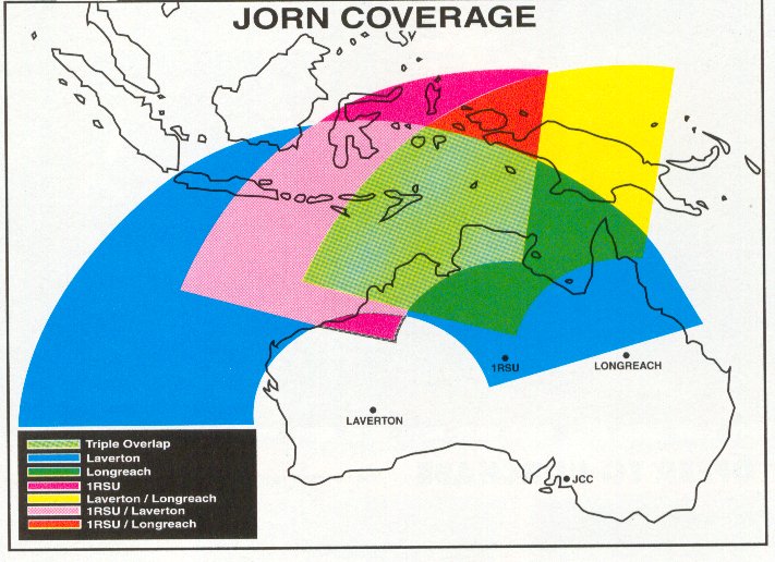
If this is true range, I checked the Google Earth map, MH370 last ping arch and predicted dipping area is within the range. And with 777 jumbo jet, it's very hard to believe Aussi radar saw nothing-it would be showing in the range for hours and it's not a US Stealth jet! Also, according to paased-out-fuel exhaustion-crash theory, the plane would most likely broken into pieces, even an pilot oriented landing at sea usually broken apart like this
and a broken 777 would have created hundreds of floating debris-many of them are plastic/foam and would never have sunk into ocean bottom, and they searched the whole area for weeks with predicted crash area (not far from the newest one) and weather/ocean currents in mind, yet not able to find one piece of evidence-it is really mind-boggling!
P.S. Aussi DOD declined comment on that and source said the radar was not tasked to watch west Indian Ocean- that's great
Last edited:
bume
Member
In my opinion all these lies, half-truths, data that is kept secret, mistakes etc. by the government and military officials is a far far bigger issue than anything GR has claimed. Also the group of people that should matter the most in the middle of it all are the family members of the victims, and it's clear that the officials have not just failed miserably but angered and caused additional grief for a lot of them. That in itself is not a big surprise, as that's how such officials tend to work.
As usual, groups with shared opponents tend to find friends in each other and GR certainly wants to give such image towards those families and at least some of them seem to agree.
In this case, the officials apparently once again made the absolutely worst choice on how to handle GR claims. The sensible choices would have been:
1) Make it clear that GR tech does not work and there's no reason to check it. All this time GR has simply requested numerous times that they can give an online presentation of their tech to whoever experts the officials can use. That wouldn't take much time from anybody. After that the experts could have said that yes, we heard what they said, that's bs. Why is that so hard? It would be much easier to trust some experts saying the tech does not work and they know that because they heard how it is supposed to work right from the source, instead of some experts saying that they do not know any tech that could do what is claimed.
2) Simply check the location, communicate clearly what has been checked, how, where, and what the results were. Back then some officials expressed their anger that such search would waste resources better spent elsewhere. In my mind that has more to do with trying to redirect the blame of their own failures than any real concern of such resources. Were those Bangladesh navy vessels ever destined to be used in the official search zone near Australia? I don't think so. And how much resources did the official search waste on the precious early days while searching the wrong area just because some radar data was kept secret?
Instead of some sane choices, it now seems that they didn't check out the tech, gave it some credibility by officially starting some search based on it, apparently actually lied and didn't do it anyway, and communicated the whole thing pretty badly. Which can be explained if that poor communication was just covering up a lie. Could they have done any more mistakes? Oh, actually they could and did. At the time the Bangladesh search was announced, Malaysia already said they where considering sending their own ships there as well, so they also already managed to show their official distrust that Bangladesh could do such a simple job. And in the end they sent nothing there. And quite possibly nobody did. Why should anyone trust such officials?
And once again I have to emphasize that all of this does not mean GR tech makes any more sense. But I can't blame anyone of rather siding with GR than those who have already clearly failed in so many ways and so many times. There has also been so many red flags on the official side of things that I wouldn't be too surprised if some of them know a whole lot more than what they are telling. Considering GR connections to Sevastopol and Ukrainian/Russian militaries, I can also think of scenarios where GR could have been used as a pawn in some political game to actually reveal something in that specified location that was actually found out in some other way than the GR tech. Hence it would have been interesting to see someone actually checking it out, regardless of what and how it was claimed to be found.
derwoodii
Senior Member.
P.S. Aussi DOD declined comment on that and source said the radar was not tasked to watch west Indian Ocean- that's great
we'd had a long lunch that stretched to the eve that day and footy was on tele then Macka opened few cans and er um well you know things just got left aside sos bout that sure something will wash up WA coast soon nuff
David Coulter
Senior Member.
In my opinion all these lies, half-truths, data that is kept secret, mistakes etc.....
I am not prepared to comment on all of these points and many of the comments on the general search belong in another thread.
My main point is, and remains, that multispectral imaging can not be used to identify chemical elements. This is known by the entire scientific community that deals with multispectral or hyperspectral imagery. No Way, No How, No Where! So the GR claims have been and will be simply dismissed by scientists that understand imaging technology as "junk science", just as it was by the ATSB scientists. The scientific view on this is that the GR claims are analogous to a psychic drawing a trance directed map to the plane.
As I pointed out before, if GR is so confident of the plane's location, why have they not generated repeated results? They did one image months ago but they have access to 43 scientists. Maybe a few more results that confirm the initial results?
As I pointed out before, their claims of being highly respected in the exploration industry are total bunk. I work in the exploration industry and never heard of them before this incident. Companies with similar "special technologies" pop up all the time in internet postings, but never at major mining conferences. Why not? These are conferences that all the exploration decision makers attend; all companies that service and make money off the exploration industry attend and most have trade show booths.
ConspiracyAtheist
Member
JORN WAS NOT ON
bume
Member
As I pointed out before, if GR is so confident of the plane's location, why have they not generated repeated results? They did one image months ago but they have access to 43 scientists. Maybe a few more results that confirm the initial results?
Why would it make any difference in anyone's mind if they produced additional kirlian blobs? I think we all know it wouldn't, and they know it too. Also Crimea is still a mess so they likely don't have access to their scientists and those scientists likely don't have access to their facilities. At the moment even the IAEA doesn't have access to those: http://www.nonproliferation.org/annexation-of-crimea/
The only possible confirmation one way or another is an onsite (sonar) search. I don't think GR is in that sort of business or have such equipment at their disposal, and such confirmation should be done by somebody else anyway to have any credibility. And as said, I would have been happy to see either a proper check of that location OR a clear statement that their tech has been found out to be complete bunk and just not worth it. But a lie is never a sufficient answer to anything.
David Coulter
Senior Member.
Also Crimea is still a mess so they likely don't have access to their scientists and those scientists likely don't have access to their facilities.
Any science that can't be repeated by any other scientist in the field is bunk. I have proprietary methods I use for clients, but others get approximately the same results using published methods.
The only possible confirmation one way or another is an onsite (sonar) search. I don't think GR is in that sort of business or have such equipment at their disposal, and such confirmation should be done by somebody else anyway to have any credibility.
If GR really believed in their technology they would have hired a reputable independent company to ROV the site (there are more than a few in the petroleum industry in the Nordics). If the results showed an intact aircraft of 777 size on the bottom of the sea they would go public and be worth billions. But they didn't....
bume
Member
If GR really believed in their technology they would have hired a reputable independent company to ROV the site (there are more than a few in the petroleum industry in the Nordics). If the results showed an intact aircraft of 777 size on the bottom of the sea they would go public and be worth billions. But they didn't....
Do you happen to know what sort of money it would cost to perform such operation on that location? I'm guessing that would be more than what GR has. Especially to ROV it. A sonar would likely suffice.
Even if they did believe to their tech, I wouldn't expect them to believe it so blindly to risk that kind of money (if they could even get hold of enough of it). Especially since they know it's not within the official search arc and have heard some expert opinions of it, and are likely not really experts by themselves but relying on a third party, who would actually be the one worth billions. So their risk-reward ratio wouldn't be that good even if they did hit a jackpot.
As far as I know and guess, the story goes so that it was Sevastopol who made the "finding", asked their Aussie partner GR to publish it, and they then published whatever Sevastopol gave them. They themselves have no way of verifying the data and likely lack the expertise anyways. And pretty soon after that Sevastopol became more or less unavailable to perform any additional work. Given such circumstances, I don't think we could really expect GR to do much more to it than they have now done.
I am not prepared to comment on all of these points and many of the comments on the general search belong in another thread.
My main point is, and remains, that multispectral imaging can not be used to identify chemical elements. This is known by the entire scientific community that deals with multispectral or hyperspectral imagery. No Way, No How, No Where! So the GR claims have been and will be simply dismissed by scientists that understand imaging technology as "junk science", just as it was by the ATSB scientists. The scientific view on this is that the GR claims are analogous to a psychic drawing a trance directed map to the plane.
As I pointed out before, if GR is so confident of the plane's location, why have they not generated repeated results? They did one image months ago but they have access to 43 scientists. Maybe a few more results that confirm the initial results?
As I pointed out before, their claims of being highly respected in the exploration industry are total bunk. I work in the exploration industry and never heard of them before this incident. Companies with similar "special technologies" pop up all the time in internet postings, but never at major mining conferences. Why not? These are conferences that all the exploration decision makers attend; all companies that service and make money off the exploration industry attend and most have trade show booths.
Just when I try to get out, they pull me back in.
I'm so terribly dismayed that you keep arguing from authority; I'd have expected the scrupulous moderator to flag this rule violation.
Specifically, you claim to speak for "the entire scientific community". First, we can use your argument to debunk the existence of wheels, because in all the years before they were invented, no one making sleds had thought of it. Second, you're arguing from authority: "entire scientific community", "scientists that understand imaging technology", "The scientific view"; all beg the question, "sez you?". Also, have you had a special presentation as to what "multispectral imaging" actually is? It's a frickin' marketing term, and you gotta be pretty clueless to claim that it contains any more information than "whitens teeth" Are you saying that NO spectral technique, no matter how modified, is relevant. I wouldn't be asking you to prove a negative, had you made an unverifiable argument in the first place.
Cheers.
Pete Tar
Senior Member
Do you have any evidence to present that the technology works?
What exactly are you claiming here, because it just looks like you want to argue semantics?
This seems to be the statement you have a problem with -
What exactly are you claiming here, because it just looks like you want to argue semantics?
This seems to be the statement you have a problem with -
What evidence do you have to the contrary?"My main point is, and remains, that multispectral imaging can not be used to identify chemical elements. This is known by the entire scientific community that deals with multispectral or hyperspectral imagery."
David Coulter
Senior Member.
Anti-Spin, please don't partially quote me:
I didn't claim to represent anybody, but I do understand my science.
The science is very straight forward: the wavelengths measured by multispectral and hyperspectral imagery (~300 nanometers to 15 micrometers) do not interact with materials at the elemental level because the wavelengths are too long. They interact with materials at the crystal structure level. Thus, you can differentiate minerals like kaolinite, dickite, illite, pyrophyllite, calcite, dolomite, etc., but you can not identify elements. For that you need much shorter wavelengths (x-ray), or laser ablation spectroscopy (both of which can't work though water).
Multispectral imaging is not a marketing term. It is imagery collected in multiple wavelength "windows" (typically >100nm in width) in the UV to Thermal Infrared region of the electromagnetic spectrum. As an example, sensors on the Landsat series of satellites are multispectral instruments. In hyperspectral imagery the windows are just smaller (typically 10nm or less) and continuous allowing a spectral response of the surface to be measured.
I can dig up some PPT's of lectures I gave to grad students at the Colorado School of Mines on the subject if that is what you want......
This is known by the entire scientific community that deals with multispectral or hyperspectral imagery.
I didn't claim to represent anybody, but I do understand my science.
The science is very straight forward: the wavelengths measured by multispectral and hyperspectral imagery (~300 nanometers to 15 micrometers) do not interact with materials at the elemental level because the wavelengths are too long. They interact with materials at the crystal structure level. Thus, you can differentiate minerals like kaolinite, dickite, illite, pyrophyllite, calcite, dolomite, etc., but you can not identify elements. For that you need much shorter wavelengths (x-ray), or laser ablation spectroscopy (both of which can't work though water).
Multispectral imaging is not a marketing term. It is imagery collected in multiple wavelength "windows" (typically >100nm in width) in the UV to Thermal Infrared region of the electromagnetic spectrum. As an example, sensors on the Landsat series of satellites are multispectral instruments. In hyperspectral imagery the windows are just smaller (typically 10nm or less) and continuous allowing a spectral response of the surface to be measured.
I can dig up some PPT's of lectures I gave to grad students at the Colorado School of Mines on the subject if that is what you want......
David Coulter
Senior Member.
The Wikipedia entry on hyperspectral imagery pretty much covers the multispectral-hyperspectral topic in a nutshell. Note that there is no mention of elemental detection...
http://en.wikipedia.org/wiki/Hyperspectral_imaging
http://en.wikipedia.org/wiki/Hyperspectral_imaging
Pete Tar
Senior Member
Nah, showing current scientific consensus is just 'an appeal to authority.'I can dig up some PPT's of lectures I gave to grad students at the Colorado School of Mines on the subject if that is what you want......

zebra100
Member
My main point is, and remains, that multispectral imaging can not be used to identify chemical elements. This is known by the entire scientific community
I totally agree with that, because the "georesonance" guys never proved a single finding in all their claims. Otherwise, they were busy hunting all the treasures buried in the deep seas for thousands of years with no time to use MH370 publicity to promote their "SCIENCE".
I totally agree with that, because the "georesonance" guys never proved a single finding in all their claims. Otherwise, they were busy hunting all the treasures buried in the deep seas for thousands of years with no time to use MH370 publicity to promote their "SCIENCE".
David Coulter
Senior Member.
I totally agree with that, because the "georesonance" guys never proved a single finding in all their claims. Otherwise, they were busy hunting all the treasures buried in the deep seas for thousands of years with no time to use MH370 publicity to promote their "SCIENCE".
Yes, that is the common sense flaw in their claims for their technology. In addition to lost treasure they could also find every ore deposit and oil reservoir. They should have wealth beyond imagination.
I assume this thread will go quiet until the next GR press release comes out........
zebra100
Member
And I believe they chose Andaman Sea is because that's where the last spot the military radar detected MH370 and with the Malaysia woman's claim seeing a downed airplane there, was a better shot than their own crystal ball georesonance photos - anything is better than nothing - since they have nothing to lose and the woman might really see something down there- Remember they claimed it might not be MH370 but some other plane -they already had Plane B.
Last edited:
bume
Member
And I believe they chose Andaman Sea is because that's where the last spot the military radar detected MH370 and with the Malaysia woman's claim seeing a downed airplane there, was a better shot than their own crystal ball georesonance photos - anything is better than nothing - since they have nothing to lose and the woman might really see something down there- Remember they claimed it might not be MH370 but some other plane -they already had Plane B.
The surprising thing though is that they specified exact coordinates. If it was just a hoax or publicity stunt, I would have expected them to be more vague so that their claim would not be so easy to disprove (if only somebody would have bothered to check that exact spot). Their continuous requests for being given the chance of representing their tech to the experts also doesn't match the pattern I would expect if they didn't believe it themselves.
Also I don't think that woman specified that exact region, let alone coordinates, so it doesn't really improve their chances of being correct in any significant way. I maintain that if this is a scam, it's a pretty poorly executed one, and any level of success is only made possible because the officials and media have failed so badly in handling this.
As for the point of getting rich by finding treasures, in theory at least, this case is a bit different if they have some sort of before and after images to compare. But what is already quite clear is that the tech they claim to have doesn't make that possible. We are lucky enough to have a real subject matter expert here who has actually looked at the documents where that tech is described (something the official experts apparently didn't bother to do) and David's judgement on that is pretty clear.
So if I don't believe to that tech, why would I still like to see that location checked? Because there is a chance we haven't heard the whole story from their side either. In fact even they themselves might not have heard the whole story from Sevastopol.
We know the military background of that university and apparently they are dealing with formerly classified spy sat tech designed for sub hunting. What if they actually saw something that's easy to detect with satellites, like debris or fuel remains on the surface at that location, or even somehow tracked that plane? And then saw an opportunity to market something else. We have already seen various media reports how reluctant the countries have been to even reveal what their radars have seen, causing unnecessary delays to the search. This might be just one more case of hiding the real capabilities they might have access to, either directly or somehow indirectly due to that background. The U.S. for example stated pretty quickly that their sats haven't seen anything, a bit too quickly I would say, and there have been media reports of some other search participants not really believing that. You can see an example of the general attitudes and secrecy with which these things are discussed here:
http://www.smh.com.au/national/miss...-sparked-search-for-mh370-20140320-355zt.html
Sure, it's all just pure speculation and the most likely scenario by far is that there's nothing in that GR location. But in my mind there are too many things where the simplest explanations just don't match my expectations and hence it's worth considering some alternatives.
Sure, it's all just pure speculation and the most likely scenario by far is that there's nothing in that GR location. But in my mind there are too many things where the simplest explanations just don't match my expectations and hence it's worth considering some alternatives.
Not this one though, as it's obvious bunk. It would be a silly waste of time.
David Coulter
Senior Member.
We know the military background of that university and apparently they are dealing with formerly classified spy sat tech designed for sub hunting.
The Soviets were never quite as clever or practical as the West thought during the Cold War. They did some amazingly cool experiments but none of these were practical. A few of the things I saw at geophysical conferences in the 80's:
- Directly connect a local power grid to the sea on opposite side of a peninsula and run a potential (voltage) line across the peninsula resulting in the highest current resistivity survey ever.
- Wrap a very expensive huge induction coil in detcord, charge it, and blow it up, resulting in a pretty darn good EM step function (on to off).
- Fire a rocket engine through a similar coil, resulting in another pretty darn good EM step function (off to on). (The energy flux induced current in the coil.)
The bottom line is they used a lot of brut force approaches to science. The smart Soviet scientists I have met had lots of time to think but very limited resources to actually build anything.
bume
Member
The Soviets were never quite as clever or practical as the West thought during the Cold War.
...
The bottom line is they used a lot of brut force approaches to science. The smart Soviet scientists I have met had lots of time to think but very limited resources to actually build anything.
When it comes to satellites though, they have been the forerunners (first satellite, first space station, etc.). And the scenario I mentioned is not even about something that special but just doing a detection others could do as well. Some just might even have a bit more luck in where their sat was looking at the time.
Obviously the Inmarsat data is the key here to what can be considered a serious alternative. Without that the expected location would be a much bigger mystery to everyone, and that mismatch was also the official reason why GR was immediately dismissed. And on the same basis many claimed eyewitness sightings. I don't know if there's an official statement to this latest one yet which also raises interesting questions how a military convoy and its radars would have completely missed the plane:
http://www.phuketgazette.net/phuket-news/New-crowdsourced-data-shows-Phuket-yacht-sighting/30940
I haven't really followed the Inmarsat debate much but its definitely interesting if all the necessary raw data still hasn't been released as the latest GR press release claimed. At least at one point Jeff Wise even called the Inmarsat report a smokescreen: http://jeffwise.net/2014/04/18/slate-why-inmarsats-mh370-report-is-a-smokescreen/
So if that Inmarsat data and the analysis that has been done can be considered a fact, then alternative locations do not make sense. Otherwise, who knows where it is. All I'm saying is that somebody might know more that has been told and for one reason or other GR could have been used as the means to reveal such knowledge. Not that it's too likely. And that could have very little to do with the GR tech in question here.
bume
Member
Don't lose sight of the fact that GR claim to be able to isolate special unseen electro-magnetic frequencies from essentially photographs. Not possible.
I don't, and as I said that part with all the fancy Kirlian blobs seems to be obvious bunk. But what I'm speculating may not have anything to do with that. And also they are advertising "over 20 technologies" they are using so even with their normal "exploration work" they are probably using some things that make scientific sense and others that don't. Those sensical parts may provide enough data to at least make some educated guesses that can give the non-sensical parts a better shot of getting some results. That remote viewing stuff might be their market differentiator (in good and bad), so that's what they would likely want to advertise even if they would get some actual results with more conventional ways. Obviously it's debatable if they actually get any meaningful results at all...
Anti-Spin, please don't partially quote me:
I didn't claim to represent anybody, but I do understand my science.
The science is very straight forward: the wavelengths measured by multispectral and hyperspectral imagery (~300 nanometers to 15 micrometers) do not interact with materials at the elemental level because the wavelengths are too long. They interact with materials at the crystal structure level. Thus, you can differentiate minerals like kaolinite, dickite, illite, pyrophyllite, calcite, dolomite, etc., but you can not identify elements. For that you need much shorter wavelengths (x-ray), or laser ablation spectroscopy (both of which can't work though water).
Multispectral imaging is not a marketing term. It is imagery collected in multiple wavelength "windows" (typically >100nm in width) in the UV to Thermal Infrared region of the electromagnetic spectrum. As an example, sensors on the Landsat series of satellites are multispectral instruments. In hyperspectral imagery the windows are just smaller (typically 10nm or less) and continuous allowing a spectral response of the surface to be measured.
I can dig up some PPT's of lectures I gave to grad students at the Colorado School of Mines on the subject if that is what you want......
A:link { }
No misquote. I think you mean that I'm taking you out of context, but I can't see how, since the essential point is the same in either case: you're claiming to speak for a large group without endorsement. But there shouldn't be any misunderstanding since your full statement is right above, so this point is a quibble.
And I understand my logic. Much of what passes here for debunking of Georesonance' technology relies on the unstated assumption that Georesonance can't know a lot more than folks here do, that is, outright denial of the possibility of their having a superior technology. Perfectly circular reasoning: since I don't know of a better technology, neither can they. Do you guys seriously consider this debunking? For a concrete illustration of how misguided expert skepticism can be very detrimental, and how it actually kept American technology behind the Soviets, check out the history of EMP bomb development.
Re elemental analysis, did you miss mention of Georesonance' use of nuclear magnetic resonance (NMR)? Note that in that technique, in contrast to the ultra short wavelengths of X-rays that you claim are essential for elemental analysis, the the centimeter-to-meter wavelengths used in NMR perform not only elemental but, under laboratory conditions, molecular structural analysis as well. In this case at least, it appears that Georesonance is including a technology which your discussion misses. Georesonance claims some 20 methodologies, so who knows what else they have in the soup, and how they're using it?
Georesonance refers only to "multispectral imaging", not hyperspectral, imaging. The significance is that on its "multispectral site", Wikipedia opens with " A multispectral image is one that captures image data at specific frequencies across the electromagnetic spectrum." This is pretty broad; it could even be stretched to encompass NMR, possibly using frequency bands corresponding to each element. It is true that the article goes on to say how that term is commonly used in satellite imagery pretty much as you describe, but it's not restricted to that exclusively. Georesonance could well be using the term in a way that differs from how you understand it, but that wouldn't by itself invalidate their claim to have located debris. All this is why I called multispectral imaging a marketing term, since Georesonance only describes what they do in the vaguest terms, like the "whitens teeth" example I invoked.
The direct way to prove them false is to go down to where they say the plane is and come back up empty. But at http://georesonance.com/20140630 Press Release.pdf. , they're threatening to do that for you. Whatever the outcome, I'd find the results and aftermath very amusing.
So basically they claim some magic technique, present zero evidence it works, and expect everyone to believe them?
If they can do what they claim they did, then they would be incredibly rich. They would also be able to demonstrate it works. Since they are neither rich, nor holding any demonstrations, then there is ZERO reason to give their story credence..
If they can do what they claim they did, then they would be incredibly rich. They would also be able to demonstrate it works. Since they are neither rich, nor holding any demonstrations, then there is ZERO reason to give their story credence..
bume
Member
Much of what passes here for debunking of Georesonance' technology relies on the unstated assumption that Georesonance can't know a lot more than folks here do, that is, outright denial of the possibility of their having a superior technology. Perfectly circular reasoning: since I don't know of a better technology, neither can they. Do you guys seriously consider this debunking?
Do you agree on these points, and if not, what would be your version:
1) GeoResonance in itself is basically just more or less a small marketing company, among several other resellers for work actually performed by Sevastopol University.
2) The fundamentals of that Sevastopol tech have been documented by themselves in documents linked here earlier, and that tech includes for example Kirlian photography, which the scientific community in general considers, well, bunk.
3) One of the two inventors of that tech is one Vitaly Gokh, a man known for pretty wild ideas, especially when it comes to pyramids of all sorts.
4) David Coulter actually is an expert when it comes to multispectral imaging. He doesn't need to read Wikipedia pages to know what it is, he could write such pages and a lot more.
5) David's opinion of that tech is pretty clear (and he has actually read those Sevastopol documents where it has been described), and also consistent with other expert opinions reported in the media. In fact, if you know any expert opinion that shows support to GR tech, please let us know.
As for GR actually checking that location by themselves, I don't think they have the resources or money to do that. Especially considering the situation in Sevastopol/Crimea. As I said earlier, I would also very much like to see someone checking out that location, but my wishes have very little to do with any belief that their remote sensing/NMR/Kirlian photo stuff actually works as claimed (for a depth of 1 kilometer).
David Coulter
Senior Member.
Another aspect of the dubiousness of GR claims are represented by this quote from their website:
Their last PR included the following statement:
If the methodology is patented it is, by definition, disclosed and documented. That is the entire purpose of a patent, you disclose your method so that you can protect your method. So why not simply attach the patent for the "one proprietary patented methodology"?External Quote:We combine all techniques in one proprietary patented methodology. Some of our patents are: 86497-UA, 55916-UA, 2272305-RU, 2007А000247-EU.
Their last PR included the following statement:
Why not provide a technical presentation on the website?External Quote:The main reason for ignoring the location is the Australian Transport and Safety Bureau (ATSB) Chairman Martin Dolan making a statement that GeoResonance methodology cannot do what we claim. This is without ever having anyone contacting GeoResonance for a technical presentation.
bume
Member
Why not provide a technical presentation on the website?
It's pretty common for companies not to spill out all the details publicly to everyone but at least require some sort of contact/registration/showing your interest so that it is worth it for them. That being said, could you consider asking some details from this guy, just for the fun of it if nothing else:
http://www.linkedin.com/groups/NMR-oil-gas-prospecting-exploration-84466.S.199347981
If you read through the comments section, there's a lot of people with some sort of relevant credentials who have asked for some details via email and got some.
He also gives some interesting details in the comments. Such as they are using analog photo *archives* brought down by landing spacecraft and capsules and emphasizes that they work directly with analog photos, not digital. So that's a further indication they are not quite as stupid as to perform some sort of digital->analog conversion as many here have suspected. But that also means such images are not really relevant in finding anything that happened after those archived photos were taken, and also raises the obvious question if they actually have any access to any current satellite.
David Coulter
Senior Member.
Same technique, different company. From the discussion:
External Quote:
Alexander Y.
Owner, Institute geophysics and problems of the Earth
At the 1st stage, we produce a unique radiation-chemical processing of analog satellite images: a given territory. In the case when the deposits are present, we carry his visualization of moving contours of deposits on a map. The technology allows determining at this stage, the number of horizons and the approximate depth of their occurrence.
In the event that deposits no have been identified, 2nd stage of the survey, of course not conducted.
The customer saves money with the 2nd part of our contract and, moreover, saves considerable resources that are needed would be to obtain such a result by classical geophysical surveys and drilling wells idle.
At the 2nd stage of the work we carry out an expedition and survey the identified deposits directly on the ground. We form sharply directional radiation, modulated spectrum of the desired substance by own equipment.
Due to the fact that the resonance of our test radiation is possible only with the desired substance (e.g., oil), radiated energy is not absorbed into other rocks and passes to a depth of not less than 5 km. In the oil is the phenomenon of nuclear magnetic resonance, re-radiation at the Larmor frequency, which we display on the surface of the earth.
During the expedition, we obtain the exact contours and deep-section of real deposits. From these data, we construct 3-dimensional computer model of deposits (rather than the anomalies, as in the case of seismic 3D).
It should be noted that not one known technology for working with satellite photographs not possible to get such results.
David Coulter
Senior Member.
You will also note that all of the people enthusiastically requesting more info and calling the technique "ground breaking, etc. are not from western companies or institutions. Most of the requests are from students that don't have the experience to spot "too good to be true" technologies. Two responses are from scientists that seem to have a grasp of oil exploration.
One who obviously got the "references":
One who obviously got the "references":
And one that debunks the technology: (emphasis is mine)External Quote:
Bob A.
Instructor at Oklahoma State University
All your references are from wiki sources or you tube and the your technology is based upon affecting water molecules, and you are detecting oil directly
Do you have any concrete data such as surveys done before drilling which drilling then confirmed?
And one that is humourous:External Quote:
Donald H.
Owner, Hill Petro; Consulting Petrophysicist
23.05.13
I attempted to post a comment, on this thread, last week, but for some reason it was never posted. I would like to point out some very important issues:
1. The originator of this thread has stated: "Our technology provides a direct detection of hydrocarbons"
2. The originator also states that the technology uses: "Terahertz range of radio waves".
These two statements add up to some rather large technical problems:
1. Petroleum reservoirs are located at depths of thousands to hundreds of thousands of feet below the surface.
2. Unlike air and free space, the Skin Depths of Terahertz radio waves in the earth are in the order of inches.
3. For example the NMR logging tools current in operation by all four major logging vendors use GHz signal frequencies and have effective depths of investigation of only a few inches.
During periods of high commodity prices "Direct Detection" technologies seem to sprout up like weeds after a rainstorm. Thirty years ago, it was Induced Polarization. This technology, at least, does have a depth of penetration of several hundred feet.
All "Direct Detection" technologies are based upon two premises:
1. Hydrocarbon reservoirs leak light components which rise vertically through the overlying sediments and form some type of anomalous concentration or halo in the near surface soil.
2. This near surface anomaly can be detected using the new technology, which just happens to include buzz words that are appearing in the popular press.
These Direct detection claims are usually based upon case histories which are claimed to show positive correlation with known oil fields. Unfortunately, nearly all operating oil fields have spills which, of course should be detectable from near surface sampling.
The originator site Wikipedia and YouTube, which are hardly accepted scientific references.
Unlike the originator, I am an experienced petroleum and mining E&P professional with over 35 years experience and an SEG member since 1963.
I am shocked that this material is being posted on an SEG discussion site.
Donald G. Hill, Ph.D.
Consulting Petrophysicist
Adjunct Professor of Petrophysics
The University of Southern California
External Quote:
Adam K.
Managing Director at Shift Geophysics
Hi Alexander,
Your previous post indicates that you don't have an education in physics.
I previously asked you to post a link to your papers, which you haven't done. Have these papers been published? Peer reviewed?
Earlier you posted a link to a slideshow, I had a good laugh,especially about using analog satellite photos and laying them over xray film, to get geological information at depth, haha.
Last edited:
bume
Member
Same technique, different company.
I know that, but the interesting thing is that this guy at least acts like he knows many details well, *acts like* he has some understanding of science, and seems to be willing to respond to questions. With a couple of questions he just might be able to prove that the GR tech (which is presumably the same from the same source) can't do what they claim
") .
. For example, if it is really so that they rely solely on old analog space image archives, then obviously they can't detect a plane that has just crashed. Of course that would leave the possibility that they have a different tech for that or something.
David Coulter
Senior Member.
I know that, but the interesting thing is that this guy at least acts like he knows many details well, *acts like* he has some understanding of science, and seems to be willing to respond to questions. With a couple of questions he just might be able to prove that the GR tech (which is presumably the same from the same source) can't do what they claim
For example, if it is really so that they rely solely on old analog space image archives, then obviously they can't detect a plane that has just crashed. Of course that would leave the possibility that they have a different tech for that or something.
You know that it is impossible to "prove a negative". Dr. Hill just pointed out that THz frequency EM can penetrate no more than inches, the poster stated they were penetrating Km's, the poster is wrong, QED. Dr. Hill, in a later post, said he was tired of wasting his time arguing with the promoter of the technique.
David Coulter
Senior Member.
Going back to the original discussion of the science involved in measuring light through water here are a couple of good references that provide all of the evidence that what GR claims to do with multispectral imagery is impossible:
Martin, Seelye. 2004. An Introduction to Ocean Remote Sensing. Cambridge University Press. Cambridge, UK.
Segelstein, David J. 1981. The Complex Refractive Index of Water. M.S. Thesis Department of Physics. University of Missouri-Kansas City.
Segelstein's data, in digital form may be found here:
http://web.archive.org/web/20041028...u/~pflatau/refrtab/water/Segelstein.H2Orefind
All you have to do is plug his data into the following equation to calculate the depth of penetration in pure water:
d(λ, χ) = λ/4πχ (m)
Where:
λ = wavelength (expressed in metres as I recall)
χ = imaginary part of the complex index of refraction from Segelstein's table (we don't care about the real part because it does not represent absorption, which is explained in the references)
π = Pi
You also must note that the usable depth measured from above the surface is 1/2 the calculated depth because the light must travel down then up.
bume
Member
You know that it is impossible to "prove a negative".
I know that all too well (been arguing with various religious nutters, they don't understand that).
But some things are still easier to prove impossible beyond a shadow of a doubt. For example considering that penetration, there's one side arguing that the max is inches and another one stating it's kilometers. As stupid as it is with a gap of several orders of magnitude, the problem still is that there's no exact limit you can specify. Hence there's the argument that you could just increase the sensitivity with all sorts of more or less magical tricks (e.g. that highlighting with a laser beam mentioned in one of the docs) and finally reach something that was thought impossible before. That essentially is one of the arguments such people tend to make, as there are several historical examples how science and technology have bypassed earlier limits. Obviously in this case there's hardly any reason to expect anyone would have been able to make any such leaps, but still with that kind of arguments "proving a negative" is pretty much impossible, especially since they can always say they have some undisclosed additional tricks involved you just don't know about.
But on the other hand, if their tech completely relies on historical analog space pictures (according to themselves), it's 100% certain they won't show anything that happened after the picture was taken. In that case they would have to either admit they couldn't detect a recent plane, or that it was done in some other way than the tech they are trying to market.
It bugs me that after all this time talking about this, we still don't have answers to several key questions about the technology they are claiming to have used for the detection of that plane. Such as was it done with satellite images or were planes involved, analog or digital images, from which sat, how old were the pictures, ... The thing is that many possible combinations of answers would already prove it can't work. They can't search the entire ocean with planes within any reasonable time, they can't get any "hidden data" from digital pictures, they likely couldn't have access to recent analog sat photos etc. The odd thing isn't that they haven't given such answers, but that apparently nobody has asked them. Without those answers it's also pretty much impossible to know if we are even arguing about the impossibility of right technologies.
Similar threads
- Replies
- 92
- Views
- 17K
- Replies
- 29
- Views
- 6K