
NorCal Dave
Senior Member.
Just for reference, I've driving past Mt. Shasta many a time, weird looking clouds over Shasta are not uncommon, even when the rest of the sky is fairly clear. Local lore is that when the clouds cover the top of the mountain, it's the Lumanarians hiding what they're up too.


https://www.mtshastamuseum.com/2021/09/17/the-lenticular-clouds-of-mount-shasta/
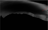
I managed to find this one image of a rare Kelvin-Hemholtz wave over Mt. Shasta form an odd rental property site for Siskiyou County:

http://mtshastasweethome.com/
https://www.mtshastamuseum.com/2021/09/17/the-lenticular-clouds-of-mount-shasta/
I managed to find this one image of a rare Kelvin-Hemholtz wave over Mt. Shasta form an odd rental property site for Siskiyou County:
http://mtshastasweethome.com/
https://skybrary.aero/articles/kelvin-helmholtz-wavesExternal Quote:Kelvin-Helmholtz waves are vertical waves in the atmosphere generated by wind shear. If enough moisture is present, a characteristic cloud, the Kelvin-Helmholtz wave cloud (also known as Fluctus), can be formed. The wind shear is the result of stronger upper winds being separated from weaker lower winds by a stable layer between. This thermodynamically stable layer is typically a temperature inversion.
When the upper layer of air is moving at a higher speed than the lower level air, it may scoop the top of an existing cloud layer into these wave-like rolling shapes. The clouds themselves occur within the stable layer at altitudes above 16,500 ft.
The presence of Kelvin-Helmholtz wave cloud is a useful indication of wind shear and turbulence. Vertical soundings can also be examined to show the vertical wind profile and the existence of any stable layers. Kelvin-Helmholtz waves are most commonly found but not limited to mountainous regions. Pilots should avoid flying at the altitude where these clouds are forming and should expect and prepare for turbulence if they have to fly through the boundary between two airstreams, for example during climb or descent.
")