Could The Gimbal Video Show an Atlas V Launch?

No, it shows this in IR:
1637444709282.png
It looks to show that, but it shows this instead:

Just as the Gimbal looked near, but was far away. Beware 2D projections of 3D scenes, they can be very deceiving. The 'horizontal clouds illusion' is the root of all your problems, think vertical and you'll understand Gimbal.
 
Last edited:
If it was Atlas, it would continue to ascent, end accelerate even further. Both features are lacking in the gimbal vid. Space is a lot higher up than just above the clouds. So I have no reason to consider Atlas.
 
If it was Atlas, it would continue to ascent, end accelerate even further. Both features are lacking in the gimbal vid. Space is a lot higher up than just above the clouds. So I have no reason to consider Atlas.
It's not seen rising due to perspective effects caused by the Atlas both rising up and speeding away fast, and by the maneuver done by the pilot. Maybe the best thing is this picture from my old Blender model:

The (barely visible) orange dashed lines are the lines of sight of the F-18 (projected on the Y plane) at the start and at the end of the video. Projected on this plane they are almost parallel and even almost coincide, this is the geometrical condition which allowed the illusion of Gimbal staying at the same height (*). Seen in this projection the lines even seem to converge, but see how it looks in 3D, the two points representing the rocket have a difference in height of 20km (and they are ~47km apart one from the other):

This model was flawed for sure, but the basic idea stays the same.


Or: consider that the Atlas may have been already tens of km high when the encounter started, and that starting with an already steep angle (looking up) some more tens of km do not increase that angle very much. Said another way, the tangent (**) function rises steeply above 45° and then it does not take much change in the angle to change a lot the height (the drawing is only for illustrative purposes):

1637455598218.png
The Atlas also flying fast away (***) and the F-18 maneuver (expecially the change in the yaw angle) did the rest, and so the viewing angle barley changed at all, and so the Gimbal appeared to stay at a constant height. Just an optical illusion.

Also, the only reference available in the video are the clouds, which do not have a constant height, but this is a marginal, finicky point I think.

Even if a quantitative numerical solution is still lacking (see the 'geometrical problem' posed in post #227), and is not exactly easy to find (see the same post), so I cannot actually swear on all this, the whole explanation I gave of the Gimbal video doesn't look to me to be at all off of this world (my opinion, of course).

(*) weren't the Gimbal video a sum of optical illusions we would not be here discussing about it, it would have been clear since long what it was

(**) using the arctangent would make for a mathematically more elegant example, but oh well

(***) the direction the Atlas is going would be orthogonally to the screen in the drawing. Now try imagine the upper red point of the triangle moving orthogonally (inside, and beyond) to the screen. Now keep in your mind the position of the side of the triangle (the red line going from the upper point to the origin) and slide it inwards together with the point, you must not imagine you are following the point inside the screen, try imagine you stay outside. What happens to the view angle, the upper blue arrow? Doesn't it converge to the angle below, the one where the encounter started? I know.. but this is not easy to explain, nor this is easy to visualize, having Blender helps a lot. I don't have the skills to make a drawing to explain this, sorry, but if you follow the instructions you will see it.
 

Attachments

  • 1637451172966.png
    1637451172966.png
    3 KB · Views: 245
Last edited:
A small bit of evidence: 2015-01-25 of appears in the EXIF data from the original .WMV files released by the DoD
2021-11-18_08-55-54.jpg

However the time difference between the two is 2m11s, but the second time codes at the start of Gofast and Gimbal are 4220 and 5245, a difference of 1025 seconds, or 17m5s.

Hence it seems like the videos must have been taken before 2015-01-25 02:27:05. Not super helpful, but consistent with the Jan 21 date

I just noticed the difference in timestamps between the start of both videos is not 1025 seconds, but 10 minutes and 25 seconds.
Go Fast starts at 4220 and finishes at 4254 (34 seconds), but gimbal starts at 5245, after 5259 changes to 5300, and finishes at 5319 (also 34 seconds... maybe the maximum allowed to convert from ATFLIR raw data to .WMV?).

The timestamp format is "mmss" (minutes-seconds). So, then maybe the plane had been flying for 53 minutes when Gimbal was recorded.

Not really an important discovery, it doesn't change anything, but I thought it was worth knowing.
 
think vertical and you'll understand Gimbal
This is a strong claim. Can you show any example of a cumuliform cloud that looks like this, with a broad, generally flat face, but sloping uniformly upward?

stratocumulus_above_angelarowe_portland_feb2014.jpg

Your example below is a regular cumulus cloud zoomed in and doesn't resemble the stratocumulus cloud layer seen in the video. Stratocumulus clouds are generally level and stretch on for many miles, and on a separate matter, it's pretty unlikely given the data that the ATFLIR was looking up (or the aircraft pitched up) at a steep angle.

1637444596654.png
 
Last edited:
This is a strong claim. Can you show any example of a cumuliform cloud that looks like this, with a broad, generally flat face, but sloping uniformly upward?

Maybe yes, I mean, I can go goggling around searching for a suitable image of a cloud. I'll do it tomorrow I guess (it's pretty late here now), I may find it as I may not.

I'm no metereologist, but it does not seem unconceivable at all for me for a towering cloud (sorry for the non-technical term, it's the best I have) with a rim which is slanted suitably forward to exist (it would be even rather easy to calculate constraints for the slant angle, given it must let the line of sight of the F-18 reach the Atlas, but I digress). I have seen clouds of any possible form and shape, in effect.

So yes, tomorrow I'll try, and I even have a better idea:


QUESTION (WANTED PICTURE)

Can anyone here with some perk for metereology find a picture of a 'towering' cloud, something like this:


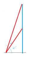
which also have an upper rim which slants somewhat inward, to be clear, something like this, seen in section:

1637457016067.png

As an additional bonus, the top of the cloud is higher than 25kft = 8300m, I cannot say how much, I'd guess 1-3km, but it's just a guess.

It doesnt even need to be a whole cloud really, just a suitable bump (say 5-10km wide, 1-3 km high) with a suitable slanting face will do.

Edit! maybe even an enlargement of one of the 'bumps' in the picture of the cumuliform cloud you posted would already be enough. I have no idea which size those bumps are, though (and all the fine structure of the cloud is anyway lost, so enlarging it will not, visually, recreate the Gimbal, but that'd be minor). This is an example I just copied&pasted , just imagine you're looking at the slanting surface from below, so you can also see the sky above:
1637458708848.png
But as I said I don't know the size of those bumps so don't take this picture at face value.


If you can find a suitable picture, you surely gain a thanks (and, in case, a citation of course).

Good night everyone

PS: my example was the first picture of 'sub-vertical cloud' I found on wikipedia, much zoomed. It's just illustrative (yet I hope convincing), to show how the Gimbal video was made. I'm not implying it was that exact type of cloud of course (I even wrote something along that lines somewhere, but it's really goodnight time now, c ya all)
 
Last edited:
This could be a good cloud:

1637464353206.png
cumuls clouds rim picture google search
But any cloud will do, really. Yet again I'm not implying that was the exact type of cloud involved, I'm no metereologist. Something like that, down to a say 10x10x2km puff in the sky, at least big enough an F-18 takes 34s to turn around it. Add military-grade ATFLIR resolution of the (fractal, over a good scale range) cloud details to the insets.

Better safe than sorry: I'm not implying the Gimbal jumped from one inset to the other of course, they are two different examples within the same cloud.
 
Last edited:
Here is a model that shows the vertical profile of the situation here :

- the earth surface is the blue line (circle equals to Earth radius at 30N, Jacksonville latitude
- the clouds are shown as the dashed grey line, their height (in m) can be adjusted (on this example, this is ~5000m)
- the dotted line is the horizon (horizontal, I've seen it's very debated what the 2° angle means, but that what I understood it was)
- the fighter is the F18 point
- Gimbal is the red point, it's position along the vertical line of sight can be adjusted, and the distance to the fighter is given (in nautical miles)
Vertical Profile.jpg
There is nothing very uncertain here, and because we don't know the cloud height I leave it as a free variable, as I leave the distance to Gimbal variable too.
I generally agree with this, except that I can't see the green sight line piercing the cloud layer in the actual video. The clouds must either be lower, or they must end (but from the satellite images, looking East, they didn't end).

I think the Atlas near the coast is too high to match the video.
I believed that once the rocket was horizontal and further along the curve, way out on the ocean, it would be in a position to be the UAP:
SmartSelect_20211121-041244_Samsung Internet.jpg
However, the cloud parallax is all wrong for an object that far away (and the F-18 shouldn't be able to get "behind it" given the times and distances).

I also believe the cloud shadows do not look like the clouds are self-lit; but there was no moon that night (see https://www.timeanddate.com/moon/usa/cape-canaveral?month=1&year=2015 ). This points to the video having been taken during the day, and the wind data reinforces this (as does the Navy having this thing on their radar?).

I don't think the idea of a F-18 in level flight pursuing a target, yet being pitched up 15-50⁰, is at all realistic.

tl;dr couldn't have been the Atlas launch
 
Last edited:
tl;dr couldn't have been the Atlas launch
I feel certain that the Navy/the UAPTF know the exact time and place of the recording; and knowing that, it would have been easy and obvious to identify the rocket launch with certainty; but they didn't. (All the UAPTF ever identified was 1 balloon. And Elizondo seems to not know what it is, either.)
 
I generally agree with this, except that I can't see the green sight line piercing the cloud layer in the actual video. The clouds must either be lower, or they must end (but from the satellite images, looking East, they didn't end).

I think the Atlas near the coast is too high to match the video.
I believed that once the rocket was horizontal and further along the curve, way out on the ocean, it would be in a position to be the UAP:
SmartSelect_20211121-041244_Samsung Internet.jpg
However, the cloud parallax is all wrong for an object that far away (and the F-18 shouldn't be able to get "behind it" given the times and distances).
I'm not sure I understand your point here. The model you show above (ihmo) is wrong. Horizons and horizontal clouds layers have nothing to do with Gimbal (ihmo): realizing this makes everything understandable. Assuming horizontal layers makes it inexplicable instead, on that I very much agree.

I also believe the cloud shadows do not look like the clouds are self-lit; but there was no moon that night (see https://www.timeanddate.com/moon/usa/cape-canaveral?month=1&year=2015 ). This points to the video having been taken during the day, and the wind data reinforces this (as does the Navy having this thing on their radar?).
For the sake of precision the lunar cycle was 1 day old (just a sliver of a crescent, I checked that some time ago): I agree with you, it did not illuminate the clouds (or barely). This does not imply the ATFLIR could not see them in IR by night. In fact, the Gimbal video is a solid proof it can. How the 'shadows' could behave, I really cannot say. But I can just look to the Gimbal video and check (imho).

I don't think the idea of a F-18 in level flight pursuing a target, yet being pitched up 15-50⁰, is at all realistic.
It wasn't. The pilot saw the target when in ~level flight, then he pitched up the nose (the only way to bring the ATFLIR to bear on the Gimbal, and yeah, maybe 50° up, that's possible, then the picth lowered, but this is another matter) and started the stern conversion maneuver (he did an U-turn, in practice) which, in the pilot's mind, was meant to allow him to get behind the target and chase its tail. 30ish seconds later everything ends, the gimbal having misteriously vanished from sight (or the F-18 went into the clouds bank, or a cloud got into the LoS, this I cannot say, anyway, the supposedly near target was nowhere to be seen) and consigned to history. He is a damn good pilot, just unable to realize the light in the sky was far far away, as is expected for any and each human being on Earth. Nothing weird is going on here.

tl;dr couldn't have been the Atlas launch
tl:dr: it was the Atlas
 
Last edited:
The F18 wasn't in level flight but had its nose pitched up to maybe 50 degrees?
Another invention that is falsified by the data: The jet is at a constant altitude of 25005 +/- 5 feet during the entire maneuver.
 
The F18 wasn't in level flight but had its nose pitched up to maybe 50 degrees?
Another invention that is falsified by the data: The jet is at a constant altitude of 25005 +/- 5 feet during the entire maneuver.
I very much agree with you with your altitude data. But being pitched up (*), even 50°, does not imply at all that the altitude also changes. It's an airplane. Check the videoclips of a 'Cobra (or Pugachev's) maneuver': the plane pitches up and even trespasses 90° (yeah, the airplane 'tumbles') without it changing altitude. I'm not implying the F-18 did anything like that of course, nor that an F-18 can do the Cobra (even if it seem it actually can, opinions diverge on the web, but there are clips supposedly showing it), it just proves an airplane can pitch up a lot and not lose altitude (just pump on the engines, should you have a high thrust/weight ratio, say 1:1, you could even climb up while pitched 50°. The F-18 obviously couldn't).

Edit: ie. this one: Saab Draken does the Cobra (sorry for not embedding the video, I need to learn how to do that too one of these days). I'm not implying this is what the F-18 did, of course! Just that you can pitch up and not lose height.

(*) I reiterate he was not level flying with his nose pointed 50° (or whatever) up. He was level flying (pitch =~ 0°), he saw the light and then he pitched up.
 
Last edited:
You cannot maintain the same altitude within +/- 5 feet during such maneuvers, plus you would hear the engines roaring on the Gimbal audio.

So far, your ATLAS hypothesis has been falsified by:
- the date reported by the Navy, which was Jan 21.
- the Navy reporting the object was in a military training zone.
- the distance reported by the pilot who had a radar return, which was within 10 nm.
- the cloud deck, which shows a horizontal cloud deck from 25000 feet that corresponds to the weather conditions at that time.
- the stern conversion maneuver of the pilot, which is impossible on just a distant light without any information on distance, heading, and speed.
- the jet's altitude remaining constant within +/- 5 feet without hearing any engine roar.
- the pilot report, which tells the object reversed direction instead of suddenly being vanished.
(and maybe I missed some)

I know you invented your own explanations to get rid of these falsifications, but most of them do not survive under scrutiny.

I know you won't stop, but I will now.
 
I feel certain that the Navy/the UAPTF know the exact time and place of the recording; and knowing that, it would have been easy and obvious to identify the rocket launch with certainty; but they didn't. (All the UAPTF ever identified was 1 balloon. And Elizondo seems to not know what it is, either.)
I'm actually pretty sure the Navy knows Gimbal was the Atlas. It did not escape the attention of my ironymeter that the launch was their own. I also think they just don't care, they're even happy about this: disinformation is the foodstuff of militaries (*) since Sun Tzu's time at least. And if they can then secure some million $ more to study mysterious inexplicable IR lights that they themselves put to the sky, even better.

(*) Notice I'm not implying this is a bad thing. Were I in the military I'd do the same.
 
Last edited:
You cannot maintain the same altitude within +/- 5 feet during such maneuvers, plus you would hear the engines roaring on the Gimbal audio.

So far, your ATLAS hypothesis has been falsified by:
- the date reported by the Navy, which was Jan 21.
The date cannot be ascertained, we cannot know in which timezone the Navy personnel reporting 'Jan 21' was thinking. It's very much compatible with the Atlas launch. I never even ever talked about the date since I begun the 'geometrical' work.

- the Navy reporting the object was in a military training zone.
Yeah, indeed so it seemed to the pilot. Just a few kilometers away. And then it doesn't take much to be thought inside a military training range East of Jacksonville, they cover the whole upper half of Florida from the shore to some hundreds kilometers away (*)

- the distance reported by the pilot who had a radar return, which was within 10 nm.
That would be good if you could directly link somehow the radar return to the Gimbal. I told you already, the world is full of radar returns. There are not that many strong IR emitters moving fast in the sky, though.

- the cloud deck, which shows a horizontal cloud deck from 25000 feet that corresponds to the weather conditions at that time.
'which shows a horizontal cloud deck' is an uwarranted assumption, get rid of it and you'll understand Gimbal. Clouds can slope any way they please to.

- the stern conversion maneuver of the pilot, which is impossible on just a distant light without any information on distance, heading, and speed.
Are you sure? Navy pilots are the cream of the best of the best. And he thought the Gimbal was just beside him. Gotta get that bogey! [I have omitted the probable expletive].

- the jet's altitude remaining constant within +/- 5 feet without hearing any engine roar.
I really have no clue about how much the engine noise will be attenuated inside the cockpit and how much noise the microphone will pick up. Maybe you can make a convincing argument from your idea, try doing it.

- the pilot report, which tells the object reversed direction instead of suddenly being vanished.
(and maybe I missed some)
He also said (not sure if he really said that, but you get the idea) the object was near him. There have been pilots who shot Venus, thinking it was close to them. And then a reversal is just a geometrical (call it 'perspective' if you like) thing. A little less turn ratio here, a little more there, and I bet you get any reversals one may wish. I'd just rather not do the necessary data-mining and calculations myself.

Edit: I may have misundertood the meaning of 'reversal', I took it to mean 'the object wiggled a bit, briefly reversing his trajectory in the field of view (then disappeared)'. But maybe the meaning is 'the pilot saw the object suddendly reversing his track and darting back at great speed': in this case we could discuss for hours about human perception, human memory, physical possibility of such a thing and the like without ever arriving to a consensual conclusion. I'm content with what I already found, it looks to me a pretty good debunking case actually, but just my opinion.

I know you invented your own explanations to get rid of these falsifications, but most of them do not survive under scrutiny.
I'd rather say I fitted the available data to a realistic situation, and it all fits seamlessly. Just my opinion.

I know you won't stop, but I will now.
And I'm sorry to hear that. You were one of those who gave me ideas (ie. the stern conversion maneuver iirc). Without you all (and, I have to say, expecially without my harshest critics, whom I therefore thank) I would have gone nowhere. When I'll 'publish' my final 'report' elsewhere here on Metabunk you will all get the merits you deserve. Unless you don't want of course, just let me know.


(*) sorry if I don't link the map. I investigated maritime exclusion zones around Florida while looking into the 'it was near Jacksonville claim' and I can't find it now here on the spot. It was an official document, that I remember, and military zones have names such as W158 or the like, iirc.

Edit: got it
1637502084840.png
https://www.denix.osd.mil/sri/polic...se-areas-figures/SRR2012-AppendixCFigures.pdf
 
Last edited:
For the sake of precision the lunar cycle was 1 day old (just a sliver of a crescent, I checked that some time ago): I agree with you, it did not illuminate the clouds (or barely)
The moon was not visible because it set at 18:20 ET at Cape Canaveral, and the launch was at 20:04 ET.
This does not imply the ATFLIR could not see them in IR by night. In fact, the Gimbal video is a solid proof it can.
That's circular reasoning.
disinformation is the foodstuff of militaries since Sun Tzu's time at least
They classified this video. The only people they'd have been "disinforming" was AATIP. I don't think passing bad information to other parts of your organization is "the foodstuff of militaries".
 
The moon was not visible because it set at 18:20 ET at Cape Canaveral, and the launch was at 20:04 ET.
The ephemeris I didn't check, just knowing the Moon was just one day old was enough for me, but thanks for the information.

That's circular reasoning.
You are very right, I should have been more careful in my writing without sloppingly cutting corners. I amend my sentence this way:

"In fact, should the Gimbal video be confirmed to have been shot at night (*), the Gimbal video becomes a solid proof it [the ATFLIR] can [image clouds at night].

They classified this video. The only people they'd have been "disinforming" was AATIP. I don't think passing bad information to other parts of your organization is "the foodstuff of militaries".
Well, when you have a group of annoying (say) UFO believers you can't get rid of (political connections I guess, in this case, but I really don't know), it's a common tactics in organizations to create a new office where you put them, so they can play with their toys at leisure without annoying and hampering too much the people who're doing real work (there's even a name for this tactics, 'lateral flyout' (**) I think, but I backtranslated it from Italian 'svolazzo laterale' so I'm not sure). If it's US taxpayers who are paying and not the organization itself, even better.

Then, not to give informations to those who don't have a real need to know (from 5-stars generals down to the general public) is the core principle of military safety, for what I know. No problems here too I think.

(*) and we do have some evidence it was shot at night, @Leonardo Cuellar digged out a reference saying that iirc, the same reference which mentioned 'east of Jacksonville'. But don't make too much of this last sentence, I'd like to check first.

(**) Edit: actually it is 'lateral arabesque':
The lateral arabesque: when an incompetent employee is given a new and longer title and is moved to an office in a remote part of the building (easier in larger hierarchies)
https://theblogbyjavier.com/tag/lateral-arabesque/
 
Last edited:
I found this article in a local Jacksonville newspaper.
Talk to one of Gimbal's testimonial pilots.
This sentence could have a value:
"Matthew Spanopoulos said some things you see you never forget, especially the night he believes he saw a UFO four years ago."
https://www.news4jax.com/news/2019/...ieve-they-spotted-ufo-off-jacksonville-coast/
The article never actually says that Spanapoulos witnessed that specific incident; he could have been referring to another sighting.
 
The article never actually says that Spanapoulos witnessed that specific incident; he could have been referring to another sighting.
I very much agree with you, the reliability of that article is not that great. But it's also (for what I know) the only reference to the Gimbal being filmed 'near Jacksonville'. So the choice is: we can consider the source reliable, therefore it happened near Jacksonville at night, or we can consider it unreliable, therefore we have no idea where it happened nor at which time of the day. Both cases are perfectly consistent with my theory. That said, I yet have to check who exactly said what, but I'm not that worried.

Edit: I just checked. It looks Matthew Spanopoulos, the pilot (*), indeed said it happened at night, even if he's not quoted verbatim.
Matthew Spanopoulos said some things you see you never forget, especially the night he believes he saw a UFO four years ago.
Maybe he was referring to another sighting, but did the article ever mention two UFOs? And confusing the sightings would be a pretty extraordinary mistake to make, he was talking about a thing 'he will never forget' after all. Maybe the sentence means he saw the Gimbal by day, then he believed it was an UFO when night came: it could even be read that way, not much probable though.

(*) My hero! It humbles me to think what he was able to do, so quickly. I'd really love to have a chat with him, with a couple beers in front possibly!
 
Last edited:
Moderators, may I suggest that Mauro's "vertical cloud" hypothesis and the various responses be moved to a separate thread. While the effort is admirable I suppose, it has completely diluted more serious discussions related to any possible Gimbal/Atlas connection.

The "vertical cloud" is just not a viable proposition — no cloud has ever been photographed that looks like that, it's just a routine stratocumulus cloud bank that stretches on for miles, and the ATFLIR was, beyond any reasonable doubt, NOT looking up at a steep angle. As Itsme pointed out, the hypothesis has been falsified in multiple respects, but the author keeps typing and denying reality. It's long past tiresome.
 
Moderators, may I suggest that Mauro's "vertical cloud" hypothesis and the various responses be moved to a separate thread.
I very much agree, but if you're willing to be patient for a little more time before moving anything, I already planned to open a separate thread. I think I already responded to enough objections up to now to be relatively certain that there are no more serious ones lurking around. Just I want to do it when I have written some decent documents, so it'll take some days. But don't worry, here I'll only answer posts directed (or referencing) to me from now on, the preliminary work is done and I don't need to post any other 'preprint' anymore I think.

Thanks everybody, I probably abused of the patience of someone but, as I already said, I would not be anywhere near where I am now without your contributions and critics.

While the effort is admirable I suppose,
I thank you very much for this

it has completely diluted more serious discussions
No thanks for this though, but I never hold grudges, no worries

The "vertical cloud" is just not a viable proposition — no cloud has ever been photographed that looks like that, it's just a routine stratocumulus cloud bank that stretches on for miles, and the ATFLIR was, beyond any reasonable doubt, NOT looking up at a steep angle. As Itsme pointed out, the hypothesis has been falsified in multiple respects, but the author keeps typing and denying reality. It's long past tiresome.
I'll just state better and in an ordered, readable way what my case is (in the upcoming new thread), then the jury will be out I guess. Waiting for your competing explanations.
 
Last edited:
Moderators, may I suggest that Mauro's "vertical cloud" hypothesis and the various responses be moved to a separate thread. While the effort is admirable I suppose, it has completely diluted more serious discussions related to any possible Gimbal/Atlas connection.
I'm going to move this entire thread into Rambles. @Mauro's hypothesis seems impossible and nonsensical for a variety of reasons already mentioned - but specifically the Atlas being too high, and rising, unlike what we see here. The plane is in level flight, and looking down 2°, and this does not change.
 
I'm going to move this entire thread into Rambles. @Mauro's hypothesis seems impossible and nonsensical for a variety of reasons already mentioned - but specifically the Atlas being too high, and rising, unlike what we see here. The plane is in level flight, and looking down 2°, and this does not change.
[Answering here because I was specifically referenced by @Mick West in the previous post.]

Dear @Mick West , of course I keep in due consideration what you say about my theory (*). Then I still find my theory, as impossible and nonsensical as it seems at first sight, yet does have a strong explanatory power and imho is consistent with the data (**), so, if you allow me, I'll go on with my plan to open a new thread where I shall present it in a more coherent form.

I'm even happy to get the chance to publicly (***) ask you for the permission to do it: I think that technically a thread titled "Claim: Gimbal video imaged ATLAS V 551 - MUOS-3" would be legit to open here on Metabunk (in the Navy videos section), but I also understand very well it could be considered an abuse of Metabunk from my part, so if you answer me, say, 'sorry Mauro, go post your nonsense somewhere else' I will just do it and I'll remain a friend of Metabunk as I was before (and I hope you will all do the same with me).

I don't want to waste your time, I'd just like to remind that it's not so uncommon for perspective effects to make things look a different way than they actually are, possibly including things high and rising appearing to be low above the clouds and at a steady altitude. Gimbal is a 'Complicated illusion', as you said in the May 29, 2021 article on the San Diego Union - Tribune, and if it weren't it'd have been explained since a long time. I just think I found how that illusion(s) worked in practice, which then gives rise to interesting consequences.

Cheers Mick, cheers everybody

PS.: Just in case, should anyone in the meantime start wondering if my theory is actually that farfetched I am glad to give explanations or answer any question (by PM of course (****)). I perfectly understand getting a coherent idea from reading all what happened in this thread is both not easy and quite cumbersome.

PPS.: I'd rather spare the moderators a lot of work moving the relevant posts to 'Rambles', after all my theory can very well be a ramble, but it's surely on topic in a very very specific thread which noone who already thinks 'Gimbal was the Atlas' is a nonsensical proposition is compelled to read. But no problems for me in any case!

(*) I think 'hypothesis' can be replaced by 'theory' as things stand, but it's just me.

(**) 2° included

(***) I would have anyway asked you by PM before doing it, just I think things done publicly are better when that's possible. Atypical Italian here. But if you prefer, just answer me with a PM, no worries at all.

(****) I pray you though, state as clearly as possible what your claim or question exactly means, take your time to spend a few words on it please. It's very difficult to answer objections where I (and surely it's my fault!) can only try to guess the meaning. Help me understand.
 
Last edited:
Just thinking about the time/date:

The Navy did not offer the exact designation numbers for the videos, but did reveal the dates for all three incidents. “[The] dates are 14 November 2004 for ‘FLIR1’ and 21 January 2015 for both ‘Gimbal’ and ‘GoFast.’”

https://www.theblackvault.com/docum...ially-acknowledged-encounters-with-phenomena/

Greenewald posted that on September 11th 2019 - kind of strange how the NYT posted a date of January 20th almost six months earlier - and also strange that it's only there as a footnote to a video, whereas the article itself never gets more specific than "early 2015".

Greenewald says:

"I was the one to originally get the U.S. Navy to respond on dates [in September of 2019), which at that point, was never revealed before."

www.reddit.com/r/UFOs/comments/oaxkgq/comment/h3m1ya7/?utm_source=share&utm_medium=web2x&context=3
Content from External Source

Has anyone contacted Greenewald to see if he knows whether it was UTC/Z/local, or whether he has more info on a specific time?

I also notice in that Black Vault article that the location of the Normandy was stated as being "off the coast of Florida and Georgia. Specifically, a little more than 100 miles east, equidistant between Jacksonville and Savannah" and that the aircraft carrier (the Roosevelt) was hypothesised as being close by. Ie, here:

1637686045198.png

I searched metabunk for Savannah and haven't seen it mentioned. Could it be that the plane was located more northerly than thought, and that "off the coast of Jacksonville" comes primarily because they were in the JAX OPAREA (Jacksonville Operating Area)?

Apologies if these things have already been covered; there are a lot of posts on the subject and I haven't read them all.
 
Last edited:
Ryan Graves gives a good summary of the Gimbal events. He shows that the incident took place near Jacksonville (in fact that is even the title of his slide).

Screenshot 2021-11-18 130530.jpg

I'm pretty sure he's referring to the Jacksonville Operating Area (JAX OPAREA) rather than the "Jacksonville area".

The JAX OPAREA extends almost to the South Carolina border, and as far south as Daytona Beach, plus a long way out to sea:

1637708303229.png
Source: https://media.defense.gov/2019/Mar/26/2002105506/-1/-1/1/UPDATE TO AFTT EISOEIS DOCUMENT FIGURES.PDF

Arrowed dot indicates where the Roosevelt was estimated to be (actually stated to be a little bit further East). Perhaps it was in the Ship Shock Trial Area? And as for the plane...?

Also, is it known if the Gimbal and Gofast videos were taken by the same plane?
 
Last edited:
I also notice in that Black Vault article that the location of the Normandy is hypothesised as being "off the coast of Florida and Georgia. Specifically, a little more than 100 miles east, equidistant between Jacksonville and Savannah." Ie, here:
Thank you for providing me with this information that I did not know about. If the fighters were 300NM from the coast, they were evidently further east of the carrier group. According to Graves, they observed GIMBAL when they decided to turn around to return to the USS ROOSEVELT. This would suggest that the direction in which they were looking at the object was towards the coast.
 
Thank you for providing me with this information that I did not know about. If the fighters were 300NM from the coast, they were evidently further east of the carrier group. According to Graves, they observed GIMBAL when they decided to turn around to return to the USS ROOSEVELT. This would suggest that the direction in which they were looking at the object was towards the coast.
Graves stated they saw interesting radar returns upon returning, and decided to go and take a look. So we can't be sure in which direction the jet was flying when the ATFLIR was locked on the object.

We do know the jets were low on fuel, because they were returning from a mission. So the radar targets could not have been at a huge distance, otherwise the jet would not be able to reach them.
 
I found this article in a local Jacksonville newspaper.
Talk to one of Gimbal's testimonial pilots.
This sentence could have a value:
"Matthew Spanopoulos said some things you see you never forget, especially the night he believes he saw a UFO four years ago."
It looks like Matthew Spanopoulos, the pilot (*), indeed said it happened at night, even if he's not quoted verbatim.

Matthew Spanopoulos isn't a pilot, he's a cell phone salesman who also thought he saw some different UFO near Jacksonville in 2015 - apparently this one:

1637708171356.png

The juxtaposition of his tale with the Gimbal stuff in the News4Jax story is weirdly reported, and it seems that quite a lot of places online have confused the facts from that and are now stating that "Matthew Spanopoulos, a Navy pilot, said/saw..."

1637707377211.png

Pretty hilarious really. I'm sure he got some fun out of that. :)
 
Last edited:
Thanks for that. Much appreciated.

THE ENCOUNTER STARTS

The F-18 is flying west, with a bank of clouds on his left, the upper rim of the clouds is higher than the F-18. The pilot sees on his left, up above the rim of the clouds, a fast-moving light. This is the situation:

1637288974858.png

The pilot thinks the Gimbal is nearby, just above the clouds near him.

Hi Mauro, what's the reason for thinking the plane was so far south?
 
Last edited:
Thanks for that. Much appreciated.


Hi Mauro, what's the reason for thinking the plane was so far south?
There's no reason actually. That drawing is just an example to show what my reconstruction of Gimbal looks like, it does not pretend to identify a specific position. In this post I then added this drawing:


With some added explanations:
The F-18 cannot be placed too much to the west side, nearer to the coast, or it will look at the rocket the wrong way. If it is too much east the video should be shorter, because the Atlas 'turns off' at the end of the marked trajectory. Too much south and the pitch angle will become too steep. There is more berth on the north, the problem there is not to have the F-18 too far from the Atlas, it must be near enough for the IRs to create glare into the ATFLIR. I cannot certainly say confidently how much this distance can possibly be, but in the order of 200kms look reasonable to me, that's about what's depicted in the drawing.
So the F-18 can very well be in a more northern position (even significantly), but I cannot really say how much. On the upside, the more north the F-18 is, the less it needs to pitch up it needs to catch the Atlas in the ATFLIR (and the illusion the Gimbal keeps the same height in the sky will be stronger too).

Let me know if you have more questions @Rory
 
Last edited:
Matthew Spanopoulos isn't a pilot, he's a cell phone salesman who also thought he saw some different UFO near Jacksonville in 2015 - apparently this one:
Ah I really don't know! That's the name in the article from the Jacksonville newspaper, whom I already considered not that reliable. I'd really like to know with certainty the name of the pilot (and its military ranking too, so I know how to refer to him properly). If you know anything about it I'd be glad to hear.
 
Last edited:
If you know anything about it I'd be glad to hear.

Alas, I probably know less than most since I'm so knew to the Gimbal game. All I know - or think I know - is that he was a VT-9 instructor pilot and his WSO was working in the Pentagon in 2019. But no names unfortunately. :(

That's the name in the article from the Jacksonville newspaper, whom I already considered not that reliable.

Yep. I think somebody at the website watched the original news story video, wrote it up in a pretty poor way as an article that didn't make things clear, and then other people read it as Spanopoulos being one of the pilots when he definitely isn't, and was talking about a different UFO.
 
Sure. If the carrier was here:

1637710147527.png

is that better or worse for your hypothesis?
I'd say it's quite compatible. Don't quote me on this (I haven't checked) but I guess an F-18 has a range of some hundred kilometers (expecially if it was in an air superiority configuration). With air refuelling (as someone suggested, sorry if I don't dig out the reference now) the range becomes effectively unlimited, but I don't really need to resort to that I think.

Edit: mama wikipedia says 2017km, but that's too far off (maybe it's for a one-way trip in clean configuration). I'd bet on ~500km in AA configuration with say two AIM-9 and two AIM-120 missiles, which should be typical, but yet again, don't quote me on that. I guess a Combat Air Patrol could hang out say 250km from the battlegroup, but I doubt that F-18 was on a CAP, I think CAPs always have two planes, but yet again I cannot know for sure.
 
Last edited:
Matthew Spanopoulos isn't a pilot, he's a cell phone salesman who also thought he saw some different UFO near Jacksonville in 2015 - apparently this one:

The juxtaposition of his tale with the Gimbal stuff in the News4Jax story is weirdly
I noticed that news4jax never explicitly connected Spanopoulos to the incident, good to see it confirmed. That cancels the last bit of evidence for the video having been taken at night.
 
I noticed that news4jax never explicitly connected Spanopoulos to the incident, good to see it confirmed. That cancels the last bit of evidence for the video having been taken at night.
Not that this makes it any evidence it was instead taken by day. At most it's evidence we have no idea (from published informations) at which time it was taken. I'm perfectly comfortable with that too. Point already made in post #259, if I may notice:
I very much agree with you, the reliability of that article is not that great. But it's also (for what I know) the only reference to the Gimbal being filmed 'near Jacksonville'. So the choice is: we can consider the source reliable, therefore it happened near Jacksonville at night, or we can consider it unreliable, therefore we have no idea where it happened nor at which time of the day. Both cases are perfectly consistent with my theory.

Nemo propheta in patria (nihil sub sole novum).
 
Last edited:
I just noticed the difference in timestamps between the start of both videos is not 1025 seconds, but 10 minutes and 25 seconds.
Go Fast starts at 4220 and finishes at 4254 (34 seconds), but gimbal starts at 5245, after 5259 changes to 5300, and finishes at 5319 (also 34 seconds... maybe the maximum allowed to convert from ATFLIR raw data to .WMV?).
The timestamp format is "mmss" (minutes-seconds). So, then maybe the plane had been flying for 53 minutes when Gimbal was recorded.

Not really an important discovery, it doesn't change anything, but I thought it was worth knowing.

With my limited knowledge of military airborne camera systems, I would suggest that the time of encoding (into wmv format) is not necessarily the time that the video was recorded, rather it is the time that it was taken off the recording media (the digital 'brick' that is stored in the ATFLIR) after the F/A-18 had landed. This might explain the differences in the time code, and also might make it more likely that the recording time was closer to the Atlas 5 launch time.

(fascinating thread by the way, great work from all involved)
 
Last edited:
Hey @Mauro & @Mendel et al - have you seen this website. https://flightclub.io - it lets you create and model your own rocket launch profile and models them in 2d graphs or in a 3d Model. The presets include Atlas V rockets and Kennedy Space Center as a launch site but they can be adjusted to any custom launch profile. It even plots where the jettisoned SRBs will land. I haven't currently got the time to model the launch of 21 Jan 2015, but maybe its something we can all work towards...? It might give us the answer to the question, "would the launch have been visible from the Jacksonville Training Zone....?"

The Rocket Profile Modeller is here: https://flightclub.io/build/choose-template
Screen Shot 2021-11-25 at 22.21.59.pngScreen Shot 2021-11-25 at 22.24.26.png
 
Back
Top