TheCholla
Active Member
Hi all,
Lately there has been discussions about the weather conditions during Gimbal, especially the wind, clouds, that are clues to help us better locating where Gimbal happened, and to recreate the event. I'd like to contribute with this because I'm familiar with this kind of data.
First, here is information we get from the video :
- the wind was westerly (i.e. blowing from the west to the east) -> one of the pilot says "the wind is 120 Knots to the West"
- Gimbal was going towards the wind -> one of the pilot says ("it's going towards the wind")
- there were clouds in the background (or foreground), as seen in the video
- the F-18 was flying at 25000 ft (~7650 m)
- this happened off Jacksonville, Florida, on January 20 or 21st 2015 (sources mentioned in https://www.metabunk.org/threads/could-the-gimbal-video-show-an-atlas-v-launch.12078/post-259341 )
Now, the weather data
There is some really good weather data publicly available nowadays, and fairly easy to visualize even for non-meteorologists. I downloaded the January 20-21 2015 weather data from the ERA5 reanalysis, this comes from the UK met office. A reanalysis is state-of-the-art weather data assimilating the most possible available weather observations throughout the entire atmosphere, and filling the blank using a weather atmospheric model. ERA5 has been made available recently, and what makes it awesome is that it has a high spatial (0.25°, ~25km) and temporal (1 hour) resolution.
I downloaded the following variables at pressure levels 925hPa to 300 hPa (~750m to 9000m) : temperature, wind, geopotential (or altitude of the corresponding isobar) and relative humidity (correlated to cloud cover).
There are very interesting things in the data, I am going to try to give a quick summary and my interpretation here, but for those who are interested, the weather data file can be downloaded here :
Source: https://drive.google.com/file/d/1nyWJTvE5mvQzAH_9m1P6F8Z97wDX5GRl/view?usp=sharing
The data format is Grib, to visualize it you simply need to install this .grib viewer : https://opengribs.org/en/downloads
Then you have to open the .grib file in the software (File->Open), then you can select the altitude in the "Altitude Tab". The 400 millibar pressure level is the closest to the F-18 altitude.
In the "Weather Map" tab, you can select the meteorological variable you wish to plot.
- Wind : if you select Wind, you can point to any location and on the left you'll see the corresponding wind speed (in Knots), and direction.
- Clouds : for clouds, looks at the relative humidity. Definition : expressed as a percentage, it indicates a present state of absolute humidity relative to a maximum humidity given the same temperature. When it's 100%, the air is fully saturated in water vapor, i.e. there is condensation, or clouds. So the areas in dark blue are where the clouds are present. Even better, we can see relative humidity at each available altitude ! At one given location, on the left you'll see the vertical profile of relative humidity, i.e. the vertical profile of clouds. This is a strong indication of the type of clouds, and of the altitude of their top. It can be super helpful to estimate where and at what time Gimbal was shot, and at what height the background clouds were (which given the horizontal angle of the ATFLIR, can also tell us about their distance I guess).
I'll spend more time analyzing this data, but here is a quick take on what I see so far.
The wind
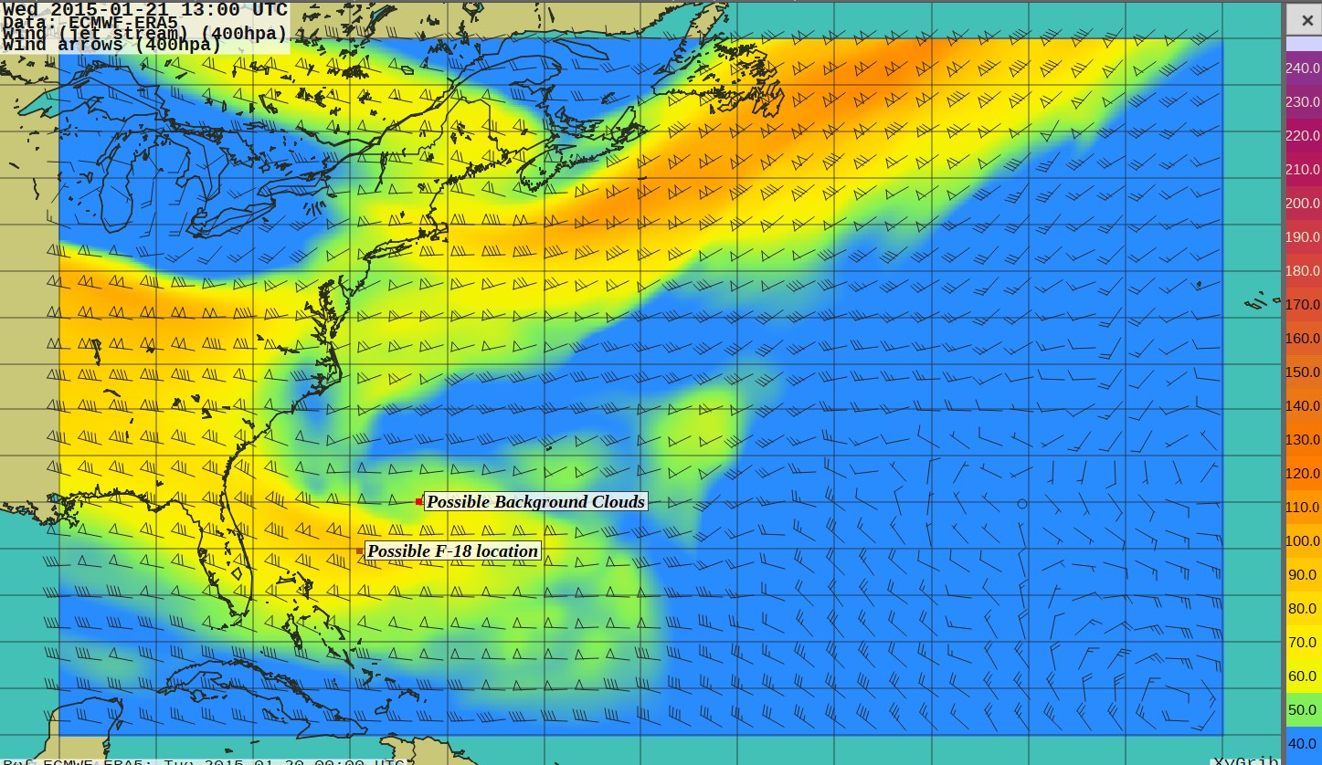
The only time when there is strong wind off the coast of Jacksonville is on January 21st. It does not reach the 120 Knots the pilots mention, but it gets as high as 90 Knots. Note that at 300 hPa it is around 120 Knots, so there are stronger winds aloft. On January 20, the winds never get higher than 60 Knots at 400 mb in this area. Based on this, I think the encounter may have happened around the marked area on this wind map. Here this is for 13:00 UTC.

The clouds

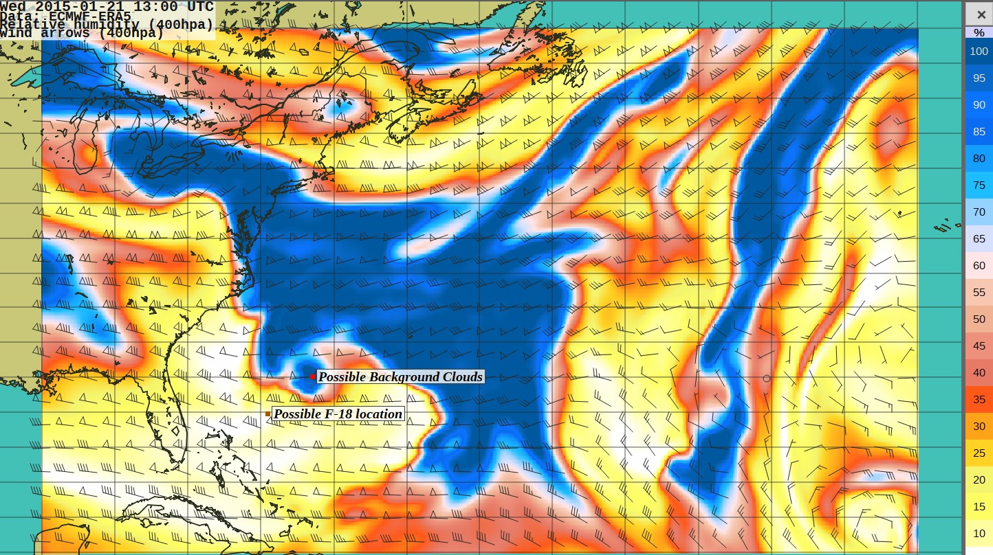
Again, the clouds are where the humidity is 100% and above (dark blue). If the position of the F-18 is in the band of high winds I point out above, the F-!8 had to go tailwind, from west to east, because the clouds were on its left in the video. There were no clouds on the south, only on the north (or left of the plane). What's interesting about them but is not visible on this map is their vertical profile. Relative humidity is >100% at 400 hPa, or around 7300 m, but not above. That would make for a cloud layer with a top at ~ 7300 m, a little below the altitude of the fighter. This is an important requirement for the clouds to be in the FOV of the ATFLIR. Given the low vertical line of sight (-2°), low clouds could not be seen in the ATFLIR. In the configuration above the clouds would then be ~100 Nautical miles from the F18, which is an important parameter for the reconstructions that have been made so far. But that's only one potential option here.
I only show an example here, I encourage you to download the data and software, and look at the data yourself. This is very easy to install and use. Hopefully this will serve as a reference for discussions of Gimbal that involve weather conditions. If only we could have the location and time of the event, we coud retrieve more precisely the distance of the clouds, and greatly refine the geometrical reconstructions. But at least we have some strong indications to guide us here.
Lately there has been discussions about the weather conditions during Gimbal, especially the wind, clouds, that are clues to help us better locating where Gimbal happened, and to recreate the event. I'd like to contribute with this because I'm familiar with this kind of data.
First, here is information we get from the video :
- the wind was westerly (i.e. blowing from the west to the east) -> one of the pilot says "the wind is 120 Knots to the West"
- Gimbal was going towards the wind -> one of the pilot says ("it's going towards the wind")
- there were clouds in the background (or foreground), as seen in the video
- the F-18 was flying at 25000 ft (~7650 m)
- this happened off Jacksonville, Florida, on January 20 or 21st 2015 (sources mentioned in https://www.metabunk.org/threads/could-the-gimbal-video-show-an-atlas-v-launch.12078/post-259341 )
Now, the weather data
There is some really good weather data publicly available nowadays, and fairly easy to visualize even for non-meteorologists. I downloaded the January 20-21 2015 weather data from the ERA5 reanalysis, this comes from the UK met office. A reanalysis is state-of-the-art weather data assimilating the most possible available weather observations throughout the entire atmosphere, and filling the blank using a weather atmospheric model. ERA5 has been made available recently, and what makes it awesome is that it has a high spatial (0.25°, ~25km) and temporal (1 hour) resolution.
I downloaded the following variables at pressure levels 925hPa to 300 hPa (~750m to 9000m) : temperature, wind, geopotential (or altitude of the corresponding isobar) and relative humidity (correlated to cloud cover).
There are very interesting things in the data, I am going to try to give a quick summary and my interpretation here, but for those who are interested, the weather data file can be downloaded here :
Source: https://drive.google.com/file/d/1nyWJTvE5mvQzAH_9m1P6F8Z97wDX5GRl/view?usp=sharing
The data format is Grib, to visualize it you simply need to install this .grib viewer : https://opengribs.org/en/downloads
Then you have to open the .grib file in the software (File->Open), then you can select the altitude in the "Altitude Tab". The 400 millibar pressure level is the closest to the F-18 altitude.
In the "Weather Map" tab, you can select the meteorological variable you wish to plot.
- Wind : if you select Wind, you can point to any location and on the left you'll see the corresponding wind speed (in Knots), and direction.
- Clouds : for clouds, looks at the relative humidity. Definition : expressed as a percentage, it indicates a present state of absolute humidity relative to a maximum humidity given the same temperature. When it's 100%, the air is fully saturated in water vapor, i.e. there is condensation, or clouds. So the areas in dark blue are where the clouds are present. Even better, we can see relative humidity at each available altitude ! At one given location, on the left you'll see the vertical profile of relative humidity, i.e. the vertical profile of clouds. This is a strong indication of the type of clouds, and of the altitude of their top. It can be super helpful to estimate where and at what time Gimbal was shot, and at what height the background clouds were (which given the horizontal angle of the ATFLIR, can also tell us about their distance I guess).
I'll spend more time analyzing this data, but here is a quick take on what I see so far.
The wind
The only time when there is strong wind off the coast of Jacksonville is on January 21st. It does not reach the 120 Knots the pilots mention, but it gets as high as 90 Knots. Note that at 300 hPa it is around 120 Knots, so there are stronger winds aloft. On January 20, the winds never get higher than 60 Knots at 400 mb in this area. Based on this, I think the encounter may have happened around the marked area on this wind map. Here this is for 13:00 UTC.
The clouds
Again, the clouds are where the humidity is 100% and above (dark blue). If the position of the F-18 is in the band of high winds I point out above, the F-!8 had to go tailwind, from west to east, because the clouds were on its left in the video. There were no clouds on the south, only on the north (or left of the plane). What's interesting about them but is not visible on this map is their vertical profile. Relative humidity is >100% at 400 hPa, or around 7300 m, but not above. That would make for a cloud layer with a top at ~ 7300 m, a little below the altitude of the fighter. This is an important requirement for the clouds to be in the FOV of the ATFLIR. Given the low vertical line of sight (-2°), low clouds could not be seen in the ATFLIR. In the configuration above the clouds would then be ~100 Nautical miles from the F18, which is an important parameter for the reconstructions that have been made so far. But that's only one potential option here.
I only show an example here, I encourage you to download the data and software, and look at the data yourself. This is very easy to install and use. Hopefully this will serve as a reference for discussions of Gimbal that involve weather conditions. If only we could have the location and time of the event, we coud retrieve more precisely the distance of the clouds, and greatly refine the geometrical reconstructions. But at least we have some strong indications to guide us here.
Last edited by a moderator:

