Chew
Senior Member.
although they pose some very valid points.
Such as?

although they pose some very valid points.
Hello Gattaca,Thank you for the replies.
Refraction is something I'm trying to understand, really how I have always seen refraction is light bending things that I can already see. I don't think it is critical for me to say 'okay that settles it, but I don't quite understand how refraction works in these situations.'
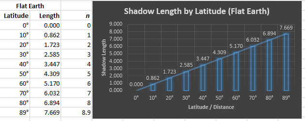
Chew, I am looking into curvature, it seems very, very clear cut, if the earth is a globe then we should be able to test this quite easily. This is one video of many showing no curvature, but it does not seem so clear to me given the simple marks I put on the pictures. Also there are plenty of videos showing no curvature, none. One video is not enough ground to dismiss all the others that show the opposite. Ultimately I will have to test it for myself.
If you believe the earth is round you should try and test that it is flat. Really there is no reason not to, it really should be simple, and I have seen better tests that one guy walking to the beach and zooming in with no building, the argument that it is a mirage is equally as valid as with debunking a flat earth one.
Testing a theory you believe imo shows you got the results you were looking for, think climate change, pesticides etc..
All in all I am not convinced, Socrates said 'I know that I know nothing', I think he has stood the test of time because there is some truth in his words.
Mind you thinking 'maybe the earth was flat' was not easy and I believe I was able to think about it without ridicule as a result of some serious reevaluation I have been doing over nearly the past year of any believe system I previously held.
Much love
If you would like to see the curvature of the horizon I can give you the calculation based upon which you may conclude that this is very hard to see from altitudes up to 20 km above the surface of the earth. And photographing it is always tricky due to lens distortion.
Thanks, I missed those postsYou can actually see it from 300 feet, with care:
https://www.metabunk.org/measuring-the-curvature-of-the-horizon-with-a-level.t7832/
If you believe the earth is round you should try and test that it is flat. Really there is no reason not to, it really should be simple
Has this link been posted yet? I didn't see it.
http://www.abc57.com/story/31830937/skyline-skepticism-the-lake-michigan-mirage
It's an interview with the photographer of the Willis Tower mirage pic. He says it was taken from "the park to the south" - Warren Dunes State Park - and that the conditions were very unusual that day.
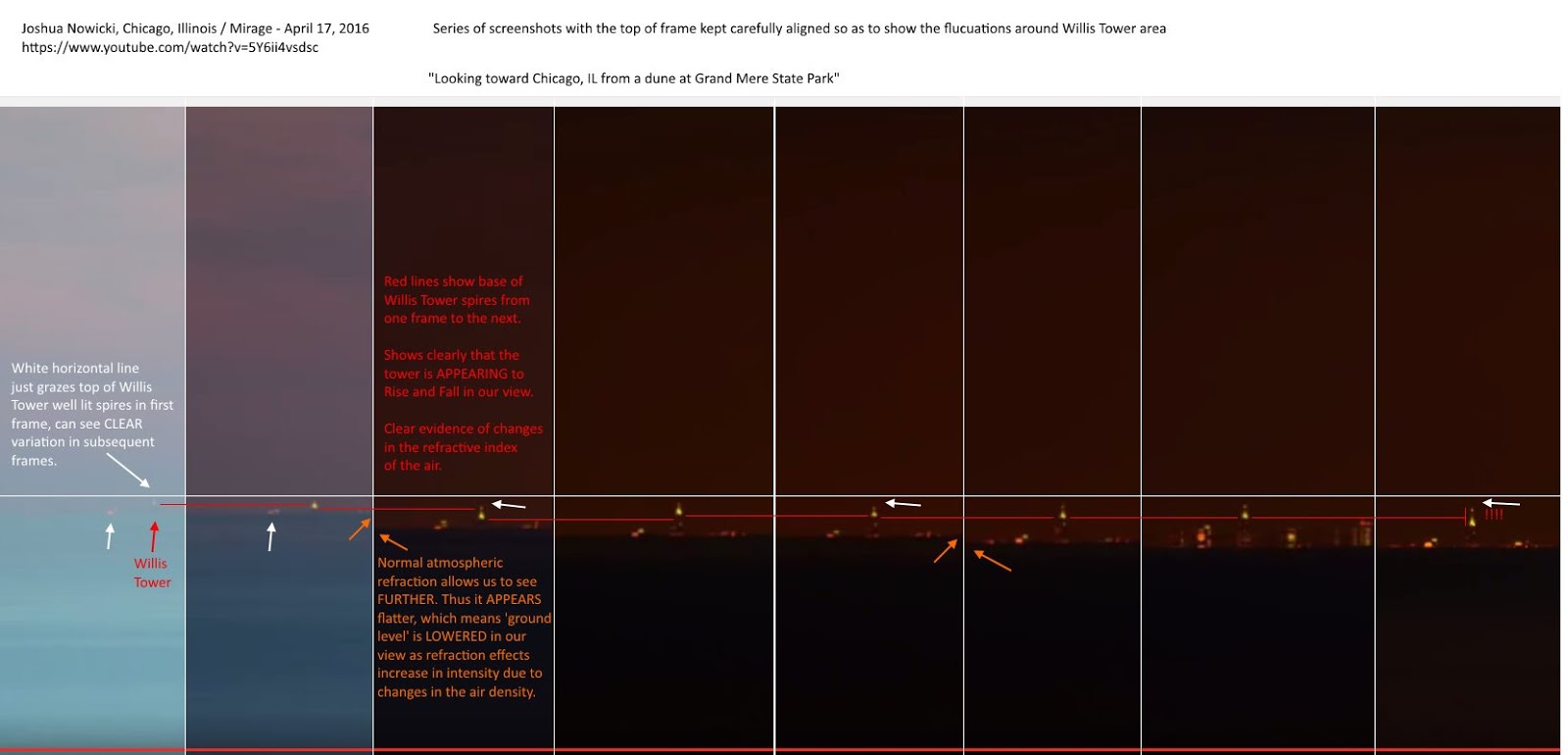
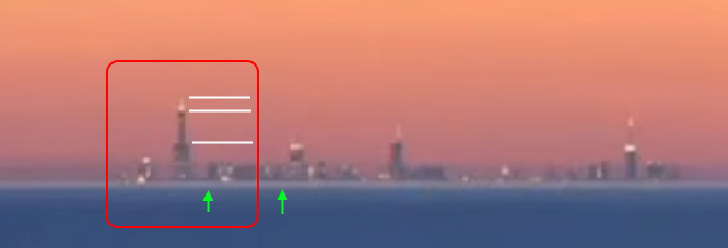
Clicking on the twitter link, he says in the third comment down that the time lapse video is from Warren Dunes State Park, and also says the same in the abc57 article about the photograph.This image was taken from Grand Mere State Park (according to Nowicki).
if the earth is a globe then we should be able to test this quite easily.
Clicking on the twitter link, he says in the third comment down that the time lapse video is from Warren Dunes State Park, and also says the same in the abc57 article about the photograph.
I think he mistakenly posted it as Grand Mere in the beginning, and it kind of stuck.
") But I really think this specific image is from Grand Mere and here is all the relevant information I could find (but always open to additional info!).
But I really think this specific image is from Grand Mere and here is all the relevant information I could find (but always open to additional info!).The only thing that seems confusing about the location is the ABC57 article which doesn't seem as likely to be correct as Nowicki's several sources for this specific photo (that weatherman doesn't seem to have the details very solid, he said you can see almost to the shoreline which is clearly not the case with entire buildings missing). But I can't rule out the possibility. Hard to say without more information I think.External Quote:"Earlier this year there was a good opportunity, It looked like 40 or 50 buildings which is the most I've ever had the chance to see."
Good work.
I guess I was letting my busyness prevent me from properly checking my memory - which turned out to be faulty this time.
Happy to be wrong!
Some more pictures of the same view from yesterday. From a height of 52, 62 and 125 metres. Also a zoomed photo from 125 metres of what is probably the ferry, from Fishguard to Ireland, passing Strumble Head at 50 miles.For fans of south Wales here are some photos of it disappearing. One is from my garden and the other from higher up. Looking towards Cardigan and Strumble head from Aberystwyth. I cannot see the Strumble lighthouse light from home,View attachment 20740 View attachment 20741 but can see the beam on the clouds under good conditions. Hewers amongst you may spot a shoal of mackerel.
I only ask this because it only assumes both objects are at sea level and not a land to land with various altitudes.
If they think this is evidence, then why don't they do 100 miles, at 3 feet elevation?
Arguing with flat earthers (or concave earthers) is generally a waste of time. Many of them are essentially just trolling - arguing a case as a funny intellectual exercise. Then there are some who take it more seriously who use the work of the first group, but often don't really understand it.
But back to this, it seems like a variation of the eponymous "Bishop Experiment"
http://wiki.tfes.org/Experimental_Evidence
Actual images of people playing on a beach would be much more significant evidence than some flashes of light. So why not simply take a photo of someone standing on the Antioch Pier, from the Benicia viewpoint?External Quote:
California Monterey Bay is a relatively long bay that sits next to the Pacific Ocean. The exact distance between the extremes of the Monterey Bay, Lovers Point in Pacific Grove and Lighthouse State Beach in Santa Cruz, is 33.4 statute miles. See this map.
On a very clear and chilly day it is possible to see Lighthouse Beach from Lovers Point and vice versa. With a good telescope, laying down on the stomach at the edge of the shore on the Lovers Point beach 20 inches above the sea level it is possible to see people at the waters edge on the adjacent beach 33 miles away near the lighthouse. The entire beach is visible down to the water splashing upon the shore. Upon looking into the telescope I can see children running in and out of the water, splashing and playing. I can see people sun bathing at the shore and teenagers merrily throwing Frisbees to one another. I can see runners jogging along the water's edge with their dogs. From my vantage point the entire beach is visible.
IF the earth is a globe, and is 24,900 English statute miles in circumference, the surface of all standing water must have a certain degree of convexity--every part must be an arc of a circle. From the summit of any such arc there will exist a curvature or declination of 8 inches in the first statute mile. In the second mile the fall will be 32 inches; in the third mile, 72 inches, or 6 feet, as shown in this chart. Ergo; looking at the opposite beach 30 miles away there should be a bulge of water over 600 feet tall blocking my view. There isn't.
And given that there are literally millions of combinations of locations in which you could do this simple experiment with a telescope, and millions of people who own telescopes, then why is the internet not flooded with millions of examples of this evidence?
If I still lived near the sea, I'd pop down an try to take photos of the beach at Point Dume (20 miles from Venice).
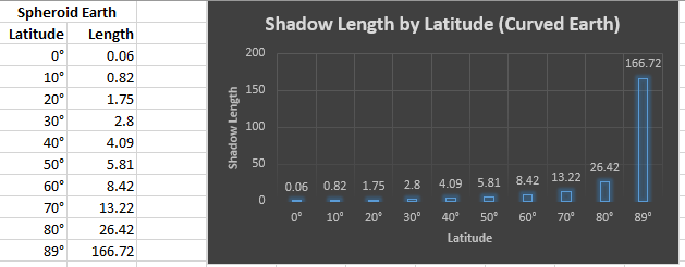
Anyone know what happened? It was not a result of me entering the wrong data.
It you click on "Advanced" you get the following explanations:My other question is about the horizon dip. Is this the amount of degrees the horizon drops from a line of sight that is level in relation to the surface that the viewpoint is above?
External Quote:Tilt is angle between vertical at the two locatons
The amount a distant object is leaning away from you
It's the distance divided by the radius (in radians)
d/r = 21120.00/20903520 = 0.00101036 radians, *180/PI = 0.05788914 degrees
Horizon Dip is the angle that the horizon is below level
as seen from the viewer height
It's arcsin(a/(r+h)), or arcsin(15838.00/(20903520.00+6.00)) = 0.00075767 radians, *180/PI = 0.04341137 degrees

- Cosmos MagazineExternal Quote:The International Space Station flies approximately 400 kilometres over thunderstorms visible during a nighttime pass. In this image, lightning can be seen flashing brightly inside the clouds below. A Russian Soyuz spacecraft (left) and Progress spacecraft (right) are seen in the foreground.
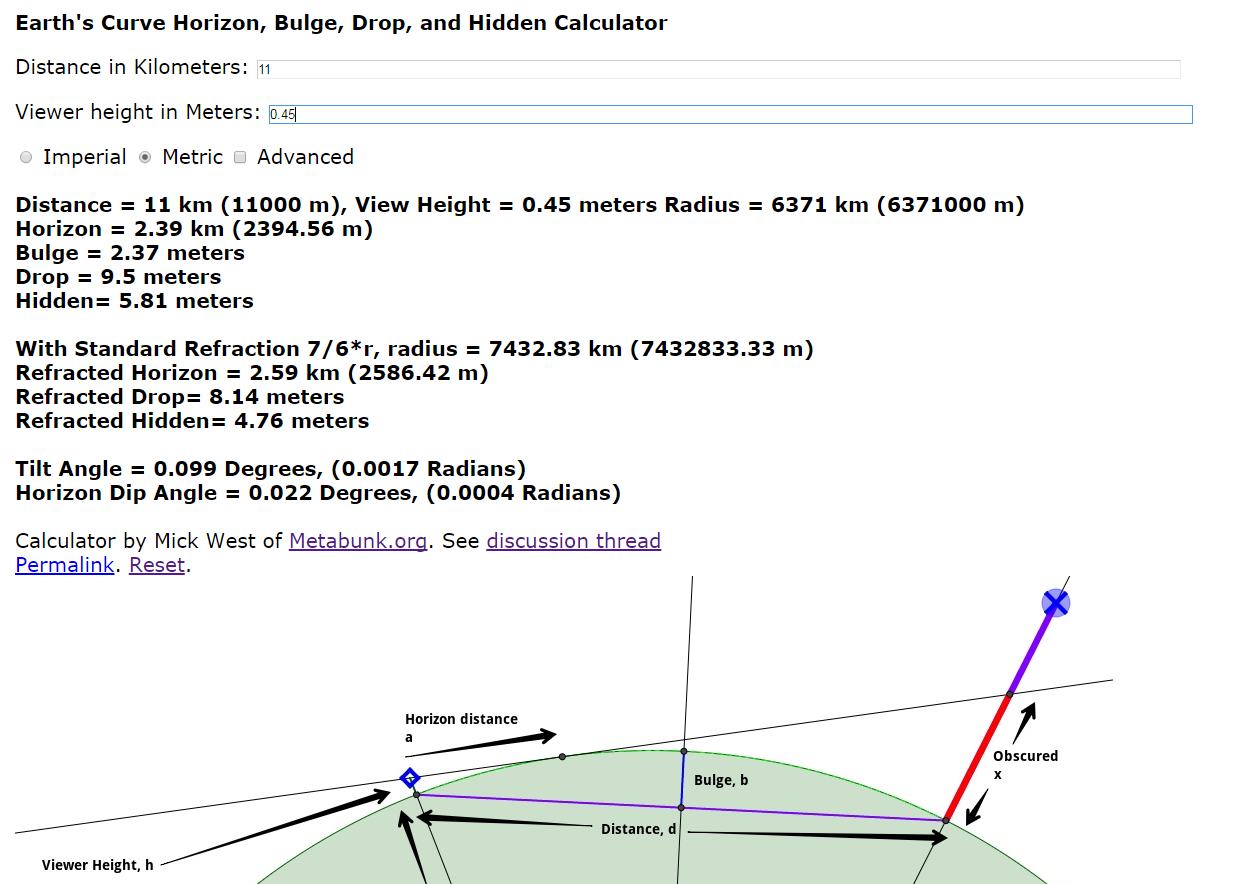
on the metabunk calculator, what is the difference between "hidden" like on the basic earth curve calculator and the "drop" on the metabunk calculator? steven hawkins has a video on proving the earth is round and they had a boat go out 3 miles and using a laser 2ft off the surface, saw the laser move up the boat 6ft to be seen. this matches the "drop" distance for 2ft observer and the distance of 3 miles, BUT, not the "hidden" value , of near only 1ft. which is correct?
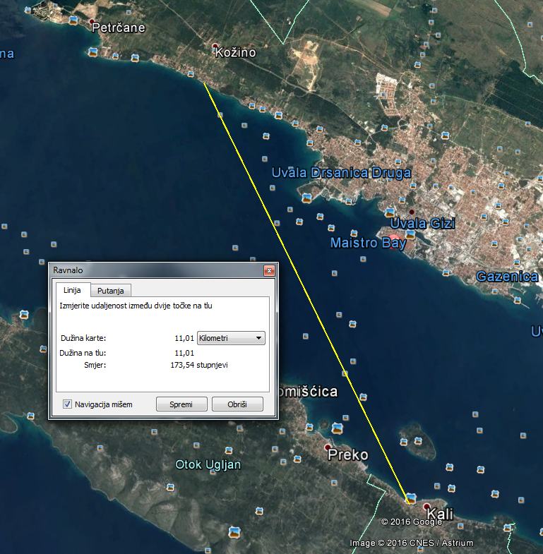
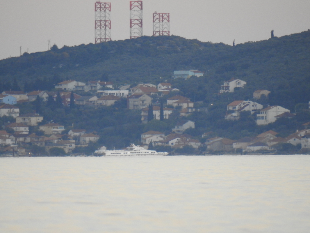
Hi all! I shot some pictures today. I wanted to share my results with you all.
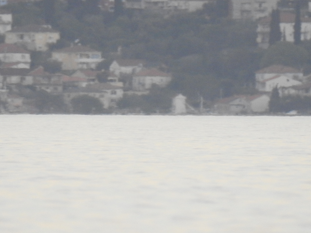
So the distance was 11km, I used a tape measure to measure cameras height above sea level and it was 45cm.
Can you give the coordinates of your camera, and of that white tower structure in the center of your image?


This one might help also to identify features better
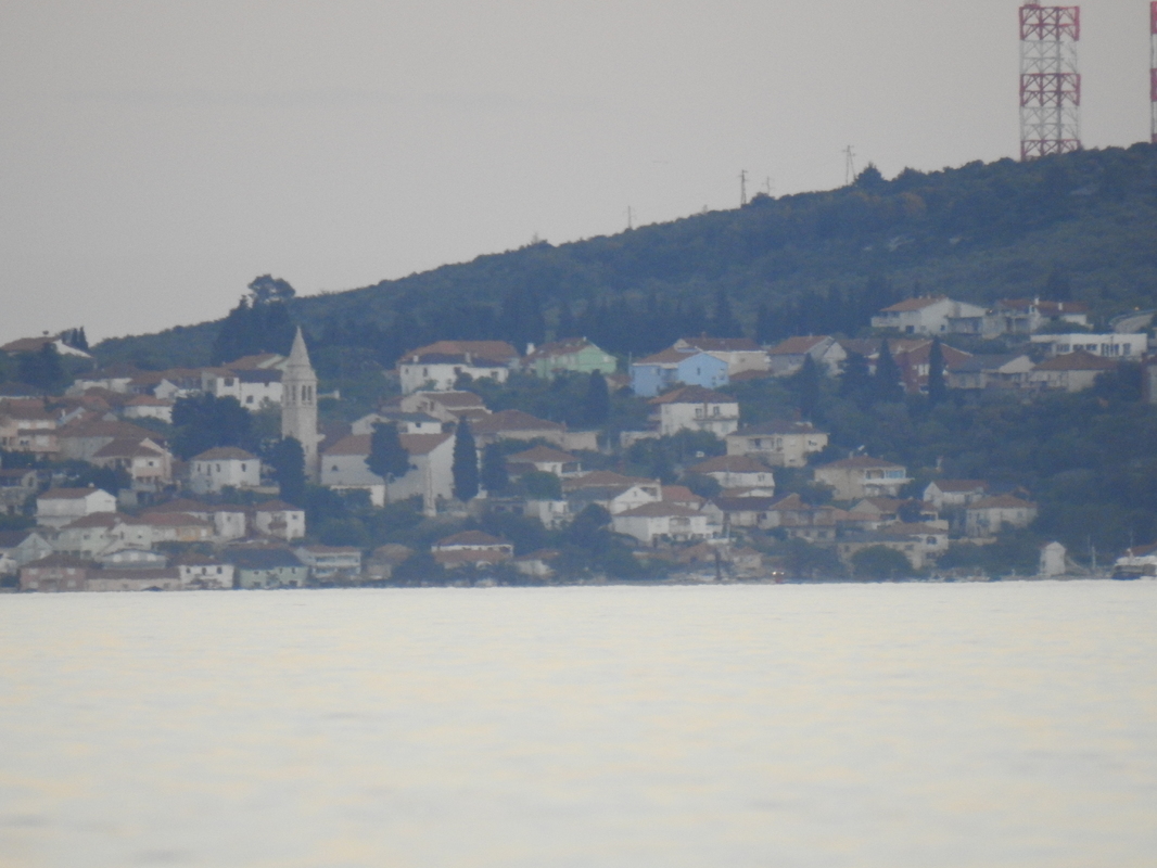
So here's that partially obscured street on the left.
https://www.google.com/maps/@44.065...4!1srlmKMZD0S2bUjgQpXQYMBQ!2e0!7i13312!8i6656
View attachment 26606
View attachment 26607
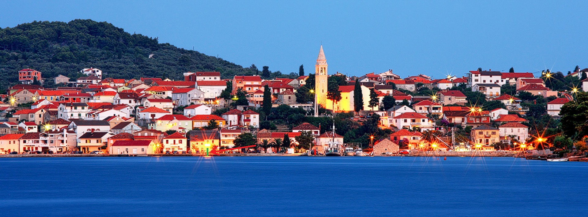
Notice the green building with the split roof.
Seems to be fairly high above the water level. So looks about right to me. Obscured by the curvature.

I think this pic is better... the aborites in your first pic are to the farthest right in below pic (pretty sure)... unfortunately so many boats is covering the 'tower' ( side of a house.just to get an idea of how the place looks like close up
I think this pic is better... the aborites in your first pic are to the farthest right in below pic (pretty sure)... unfortunately so many boats is covering the 'tower' ( side of a house.
View attachment 26608

Google Earth puts the sidewalk just in front of the green building at 9 feet above sea level. So the bottom 6.5 feet of the green building should be hidden.
you could jet over there and hold an altimeter up to the door at that levelI guess the easiest way I can come up with is
Seems possibly low. What was the camera on exactly?I used a tape measure to measure cameras height above sea level and it was 45cm.