Lake Balaton Laser experiment to determine the curvature of the Earth, if any.

Status
Not open for further replies.
Because it's a retroreflective patch. The reflection will be orders of magnitude more intense than a diffuse reflection from a white surface.


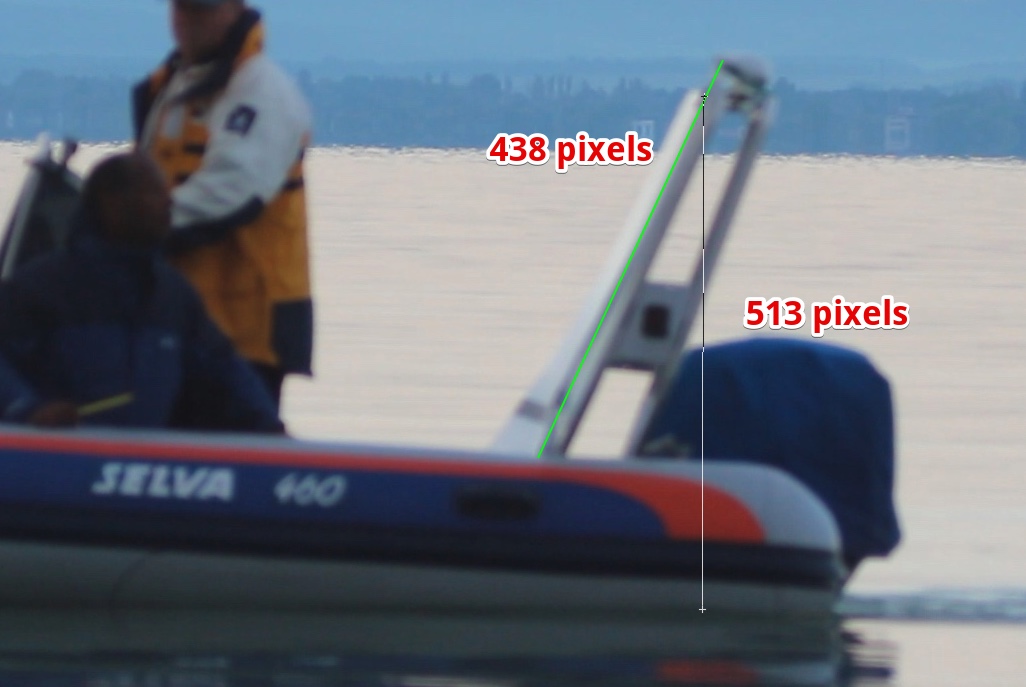
We are talking about the height of the black tape. This is more accurately measured here as 1.17m, but you claimed 1.35
https://www.metabunk.org/lake-balat...of-the-earth-if-any.t7780/page-19#post-190631

Meaning your laser is pointing down.


By analyzing the video. Did you not see the images in the post you quoted?

I don't see your point here. What is the green line supposed to be?
How can you comare two imaginary points?

Where is the black tape?
 
As a bit of a boaty person I would not worry about the boat tilting or lifting if it is moving slowly. It is likely to tilt most when semi-planing, and lift most when planing. Provided the speed is a couple of knots below hull speed, moving is not likely to be an issue, and it makes sense to move slowly underway to maintain 'steerage'.
https://en.wikipedia.org/wiki/Hull_speed
I agree it would make sense to take measurements with the boat going as slowly as possible, but I'm not sure that's what happened (it's one of the questions I asked Sandor which he chose not to address).

There are several images from the shore inset into the measurement images that show what looks like significant wake, and that the boat may be tilted up as it's possible to see more of the three people on the boat above the board. Also, as Hama Neggs pointed out, some of the timings/GPS coordinates indicate the boat must have been travelling at significant speed between measurement points (though there appears to be some clear inaccuracies in those too).

Ray Von
 
I point out, that the laser beam was leveled slightly upwards both on the GE and FE model - as shown in the video.

It looks like it is not me who needs to see the video more times.
Dave : "It's 90 centimeters"
Sandor: "okay than we raise the beam up a little bit"

does that sound like a measurement, or like 2 people talking about how much we have to lift the beam?
the measurement were taken by distance comparison to the black tape mark at 1.25 meter.

1.25 meter was measured in the harbour VERTICALLY from the water surface.
Do you have a proof of your opposite statement, Mick?
 
1.25 meter was measured in the harbour VERTICALLY from the water surface.
Do you have a proof of your opposite statement, Mick?

Yes, the length analysis with the boat sideways.

I don't see your point here. What is the green line supposed to be?
How can you comare two imaginary points?

Where is the black tape?

It's a little hard to see as wanted to get it perpendicular to the camera for accuracy. But you can see it in the video, the important points being the top of the 1m edge of the board, the top of the black tape, the bottom of the board (resting on the boat side) and the waterline.
20160911-105419-1az8g.jpg
20160911-105631-67xl8.jpg

I encourage you to repeat this analysis yourself.
 
I have added a summary of the key points of this thread to the OP
https://www.metabunk.org/lake-balat...mine-the-curvature-of-the-earth-if-any.t7780/
Great that you did that, it was definitely time for it.

Can I also suggest maybe a new thread is started? This one is mostly about the intricacies of the experiment - ie, input during the build-up, and much analysis and debate afterwards. But how about a straight, "Claim: Lake Balaton experiment proves flat earth" thread, which can be looked at purely on the merits of the video itself, debunked in the traditional manner, and not digress into debate or suggestions on how to do it more accurately next time?
 
Last edited:
What is the green line supposed to be?
it's the slant of your board.
Where is the black tape?
upload_2016-9-11_13-54-0.png

I point out, that the laser beam was leveled slightly upwards both on the GE and FE model

No it wasn't. Mick's post proves that with math.
https://www.metabunk.org/lake-balat...of-the-earth-if-any.t7780/page-19#post-190631
https://www.metabunk.org/lake-balat...of-the-earth-if-any.t7780/page-19#post-190609


Dave : "It's 90 centimeters"
Sandor: "okay than we raise the beam up a little bit"
except it WASN'T 90 cms. That is the point.
 
I was refering to the boat WAKE as an indication of the speed. At 3 knots or so I don't think there would be any significant tilt or lift, but the wake in the obove pictures suggested a higher speed at the time.

an 1200mm teleobjective camera video played in fast forward mode gives you a feeling that the boat is moving fast.
 
I have repeated the measurements with more accuracy using the video directly in Photoshop, the results are that the top of the tape, which you indicate at 130cm, is actually 118.5cm. I shall make a short video demonstrating this.
 
Last edited:
it's the slant of your board.

upload_2016-9-11_13-54-0.png


No it wasn't. Mick's post proves that with math.
https://www.metabunk.org/lake-balat...of-the-earth-if-any.t7780/page-19#post-190631
https://www.metabunk.org/lake-balat...of-the-earth-if-any.t7780/page-19#post-190609


except it WASN'T 90 cms. That is the point.

yes that wasn't - so?

what does it have to do with the 1.25 black tape marked on the board?

how can Mick compare the 2?

what makes people say that we did not meaasure VERTICALLY from the water surface in the harbour?

DO you think we are deceiving you?
 
what makes people say that we did not meaasure VERTICALLY from the water surface in the harbour?
the answer is in this thread. go back and read.

i have a quick question that probably has nothing to do with anything... you say you need a precision of .005degrees for the laser. what is .005 degrees in centimeters? Does anyone know?


degreecloseenough.jpg


anyway, it's not Dave's fault the leveling measurements are wonky. you made it near impossible for him to do it. next time you should use a plumb line tape measure. this is just an example of what not to do, here he is measuring 50cm which he does do vertically but then he marks the spot with his thumb... COMPLETELY removes his hand fromt he board for quite a while then just puts a mark on the board wherever he wants.
50a.JPG

if you did this: (below) he could have the pen in his right hand, hold the tape with his left, be sure to get a straight vertical plumb line and your measurements would be way more accurate.

P1020744.JPG
 
Here's a more detailed analysis of the height, comes out as 118.5cm to the top of the tape, which you have labeled as 130cm. The methodology is the same as before. Measure the edge of the board, and then use that to calculate the height of the top of the tape above the water.

Source: https://www.youtube.com/watch?v=kdkGRDC553A

1m board length = 452
20160911-161826-zpdfl.jpg

Height 536
20160911-161723-l3t44.jpg

So height = 536/452 = 1.185 (118.5 cm) where Sandor claims 130cm (top of tape)
 
Last edited:
PS. @Sandor Szekely let's completely forget about a globe earth, as the FE math is easier for me. The simplest way to know/test if your laser is going "up" at ALL is: when you move your boat to the next location the laser dot will not be lower than it was at the last location.
 
here he is measuring 50cm which he does do vertically but then he marks the spot with his thumb... COMPLETELY removes his hand fromt he board for quite a while then just puts a mark on the board wherever he wants.

He appears to put a crease in the board with his thumbnail, where he then puts the marker mark. However, i'm not sure he has the tape accurately vertical when he measures.
 
The original 50cm mark may have been reasonably close, but the vid doesn't show them putting the 130cm tape on the white board. Maybe they just measured up the angled board from the 50cm tape?
 
Interestingly, the 50cm appears to be a lot more accurate than the 130cm line.
20160911-123657-l9gwi.jpg

(you can't see the tape there, but I set the line using the same method as outlined in the video)

233/452 = 0.515, so 51.5cm, within the bounds of accuracy based on Dave's measurement, and variation in the boat's position (less people, but also less blanced).

So it seem like Dave measured fairly vertically up to the 50cm point, and then did subsequent measurement along the edge, not vertically.

This validates the 118.5cm measurement, and hence is more evidence the laser was pointing downwards.
 
Yes, the length analysis with the boat sideways.


It's a little hard to see as wanted to get it perpendicular to the camera for accuracy. But you can see it in the video, the important points being the top of the 1m edge of the board, the top of the black tape, the bottom of the board (resting on the boat side) and the waterline.
20160911-105419-1az8g.jpg
20160911-105631-67xl8.jpg

I encourage you to repeat this analysis yourself.

Your measurement line is wrong, you measure the metal frame not the board.
The board is in an angle that you do not calculate.
I know we measured the mark perfectly at 1.25 m so just watching your debunk on this..


Mick.png


by the way - how is Dave holding the tape measure here?
not that it matters, as this isn't a measurement position eighter

 
the answer is in this thread. go back and read.

i have a quick question that probably has nothing to do with anything... you say you need a precision of .005degrees for the laser. what is .005 degrees in centimeters? Does anyone know?


degreecloseenough.jpg


anyway, it's not Dave's fault the leveling measurements are wonky. you made it near impossible for him to do it. next time you should use a plumb line tape measure. this is just an example of what not to do, here he is measuring 50cm which he does do vertically but then he marks the spot with his thumb... COMPLETELY removes his hand fromt he board for quite a while then just puts a mark on the board wherever he wants.
50a.JPG

if you did this: (below) he could have the pen in his right hand, hold the tape with his left, be sure to get a straight vertical plumb line and your measurements would be way more accurate.

P1020744.JPG


okay I am not writing this down more times - it is just taking my pricious time

the C1 C2 C3 are NOT measurement points! they are leveling points and final leveling at C4

you claim here: Dave says 90 cms

YES, that is why we had to raise the beam upwards. just please listen to the next sentence in the video

we did not make measurements with tape. we marked the tape to the 1.25 cms level.
never ever in the measurements you see a tape measurement

does not matter how Dave was measureing the level of the laser, the only information of "lift the beam upwards" would have been enough. this is extra

Dave "okay that's close enough"

he said at position C4: "that's perfect"
 
So it seem like Dave measured fairly vertically up to the 50cm point,
yea he wasnt that far off with his line* ..he had a little dot he was using to eyeball. i think the bulk of the offset is because his whole body was leaning out and sitting on the edge of the boat.
de.JPG

*don't sweat it Dave, i measure like that too... which is probably why all my canvas frames are a just a tad bit crooked.
 
the C1 C2 C3 are NOT measurement points! they are leveling points and final leveling at C4

the first paragraph was a different thought than the second.. i should have put a little line in to break them up for you but i DID SAY "leveling measurements" about the dave photos.

you claim here: Dave says 90 cms
where in that post you quoted did i say 90 centimeters?

we did not make measurements with tape. we marked the tape to the 1.25 cms level.
never ever in the measurements you see a tape measurement
i know. noone is saying you did. i think you are reading through posts too quickly and not fully listening to what is specifically being said and when.

does not matter how Dave was measureing the level of the laser, the only information of "lift the beam upwards" would have been enough
yup. "lift the beam upwards" because it is still pointing down.

and it does matter because your 1.25 mark (and otehrs) on your board is wrong. as Mick fully showed with scientific data.
 
From MVI_7124, ten seconds apart, drifting vs underway at low-medium power
20160911-060959-yy9d7.jpg

And at16 seconds, showing the laser in the same spot, but mostly off the board
20160911-061400-aguuf.jpg

The pushing of the propellor will tend to rotate the boat about its center of gravity. I'd estimate the back has dropped at least 5cm.

And adding to this from the "Laser Test Part 2" video:
20160911-132959-32fky.jpg
20160911-133259-0wov4.jpg
The tape is 5cm thick, so the second image show the light nearer 10cm higher.
 
Then later:
20160911-133507-by1ho.jpg
Similar wake, but the laser has dropped a little, consistent with a slight downwards slope.

And again:
20160911-133700-in8uw.jpg
 
the C1 C2 C3 are NOT measurement points! they are leveling points and final leveling at C4

you claim here: Dave says 90 cms

YES, that is why we had to raise the beam upwards. just please listen to the next sentence in the video
But this is the point, when he was measuring 90cm, it really wasn't 90cm. So when the beam was being raised to where Dave thought it should be, it wasn't where it should be either. Mick was correct in saying the margine for error here was in the 9cm range. So wherever it was raised to was liable to be out by 9cm, so pointing downwards. We don't actually see the adjustment being made to raise the laser either, how were these adjustments made? Why did you not go back to the start after this c4 leveling and see what c1 height was now reading?
 
the first paragraph was a different thought than the second.. i should have put a little line in to break them up for you but i DID SAY "leveling measurements" about the dave photos.


where in that post you quoted did i say 90 centimeters?


i know. noone is saying you did. i think you are reading through posts too quickly and not fully listening to what is specifically being said and when.


yup. "lift the beam upwards" because it is still pointing down.

and it does matter because your 1.25 mark (and otehrs) on your board is wrong. as Mick fully showed with scientific data.

I am reading the posts accurately, indeed I see that people are just skipping my comments. I wonder if that was because I had a delay by getting approval for my comments..

I have to repeat my self again.
The beam was not pointing downwards.

Mick's "scientific data" is way wrong.

Mick - have you checked your statement of the beam leveling to 118.5 cms to be correct before you sent your youtube video viral?
You know that facebook trolls are already taking this as "THE debunk" of our measurement video?
 
We can't measure or set that on 60 meters distance it seems we need to level the laser at a further distance then 720 meters.

If we can't make the 0.001 degree precision then we can go to the other side with a reasonable laser height (or it hts the water in front)
You need a target and person with radio across the lake and a fine screw adjustment. It will drift between measurements due to temperature changes if you just set it and leave it.
 
I have to repeat my self again.
The beam was not pointing downwards.

Mick's "scientific data" is way wrong.

Mick - have you checked your statement of the beam leveling to 118.5 cms to be correct before you sent your youtube video viral?

Viral? It has 26 views.

The video was me checking it. I'd performed the measurements less accurately yesterday, which you saw, and I got 117cm
https://www.metabunk.org/lake-balat...of-the-earth-if-any.t7780/page-19#post-190631

Why don't you check my work? The video explains how it is done. Do you see a problem with the way I measured it? Is the edge of that board exactly 1m?
 
What the next experiment you are going to do @Sandor Szekely? What happened with the helicopter?

Really you should just do a Wallace experiment. That would settle it.


We are going to make a 10kms laser measurement all the way to the other side of the lake with a setup that is impossible on a GE curved surface water.

You were saying long time ago that if we are over the 6kms line and we can still see the laser then water surface is flat.
I can see now that unless we prove an impossibility without any setup arguments we will always have this discussion of the setup parameters.

Have you checked the LIDAR expereiemnt outcome? They have the same conclusion.

Have you checked the outcome of your "scientific leveling proof"?
I think it is actually not a good idea to make "debunks" in yube as it is taken like fact by others..

what is your beam height calculation on this 118.5 cms leveling setup?

did you check if it gives a NEAR reasonable value or not?
cause I saw on FB some people take this granted
 
I am reading the posts accurately, indeed I see that people are just skipping my comments. I wonder if that was because I had a delay by getting approval for my comments..

I have to repeat my self again.
The beam was not pointing downwards.

Mick's "scientific data" is way wrong.

Mick - have you checked your statement of the beam leveling to 118.5 cms to be correct before you sent your youtube video viral?
You know that facebook trolls are already taking this as "THE debunk" of our measurement video?
The beam was pointing down! You're either blatantly ignoring the fact that the c4 leveling adjustment was done after Dave took the 90cm measurement not vertical with the water. In doing this the measurement was up to 9cm below 90cm. This is factual!

Let the Facebook trolls, as you call them, think what they want. You have to remove all the possibilities for errors in any future experiments if you want critical thinkers to agree with your conclusions. It's us you're trying to convince, we are definitely very far from convinced. I'm sorry you don't like that, but how can you rectify it in the future? You tell us.
 
Have you checked the LIDAR expereiemnt outcome? They have the same conclusion.

What? Where are you reading that?
http://publik.tuwien.ac.at/files/PubDat_228814.pdf
Abstract. Airborne lidar is a remote sensing method commonly used for mapping surface topography in high resolution. A water surface in hydrostatic equilibrium theoretically represents a gravity potential isosurface. Here we compare lidar-based ellipsoidal water surface height measurements all around the shore of a major lake with a local high-resolution quasi-geoid model. The ellipsoidal heights of the 87 km2 we sampled all around the shore of the 597 km2 lake surface vary by 0.8 m and strong spatial correlation with the quasi-geoid undulation was calculated (R 2 = 0.91). After subtraction of the local geoid undulation from the measured ellipsoidal water surface heights, their variation was considerably reduced. Based on a network of water gauge measurements, dynamic water surface heights were also successfully corrected for. This demonstrates that the water surface heights of the lake were truly determined by the local gravity potential. We conclude that both the level of hydrostatic equilibrium of the lake and the accuracy of airborne lidar were sufficient for identifying the spatial variations of gravity potential.
Content from External Source
They used ellipsoidal heights (height relative to the standard ellipsoid model of the earth's sea level). There was a variation of 0.8m, after corrections for the local geoid this was far less. So what conclusion are you talking about?

As a result, a water surface model was produced, with approximately 87 million data points characterized by horizontal coordinates and adjusted elevations above the WGS 84 ellipsoid.
Content from External Source
 
Mick, may I ask what is this "update?" in the thread?

WHY are you making statements that are not true and placing them in the thread headline before my script?

"The results of the experiment were some very poor quality data. Poor initial calibration of the laser mean that the it was pointing slightly downwards instead of the intended level or slightly upwards. The laser target used was positioned so that the laser very quickly rose above it and could no longer be measured, and the laser beam diverged rapidly so as to be impossible to locate.

Since the laser seems to have been pointing downwards, the subsequent rise of the laser above the target is most consistent with a curved surface. However the very poor quality of the measurements makes this impossible to quantify"

DID you PROVE that the laser is pointing downwards?

[...]

OK. please RE calculate your measurement. it is way wrong. do not mess up this peer review with false information and making a wrong conclusion
you see people take your calculations granted - at least you should have checked what the outcome is on your proposition of laser pointing downwards!

I am really amazed that no one checked Mick's hypothesis with the measurement data.

Okay: the laser beam height should be at 3.19 meters on the GE model according to Mick "idea of laser pointing downwards"

Is that the case? IS the laser beam at 3.19 meters on the pictures? NO

How about the FE model? It should be at 0.71 meters ... is it recorded like that? NO

SO your calculation is wrong, your debunk is debunked
 
Last edited by a moderator:
DID you PROVE that the laser is pointing downwards?

Yes, I measured the height of the tape using the 1m long edge of the board when it was perpendicular to the camera.

Note that this is the only evidence we have of the height of that tape. If you would like to supply other evidence, then please do so.
 
Status
Not open for further replies.
Back
Top