
You are using an out of date browser. It may not display this or other websites correctly.
You should upgrade or use an alternative browser.
You should upgrade or use an alternative browser.
Photos of Planes and Contrails (That you took yourself)
- Thread starter Mick West
- Start date
deirdre
Closed Account
whoa. thats a beautiful shot!Lots of nice photos of nature and contrails.
whoa. thats a beautiful shot!
Thanks, I've put all my Yosemite contrail shots here:
https://www.flickr.com/photos/metabunk/albums/72157660809505650
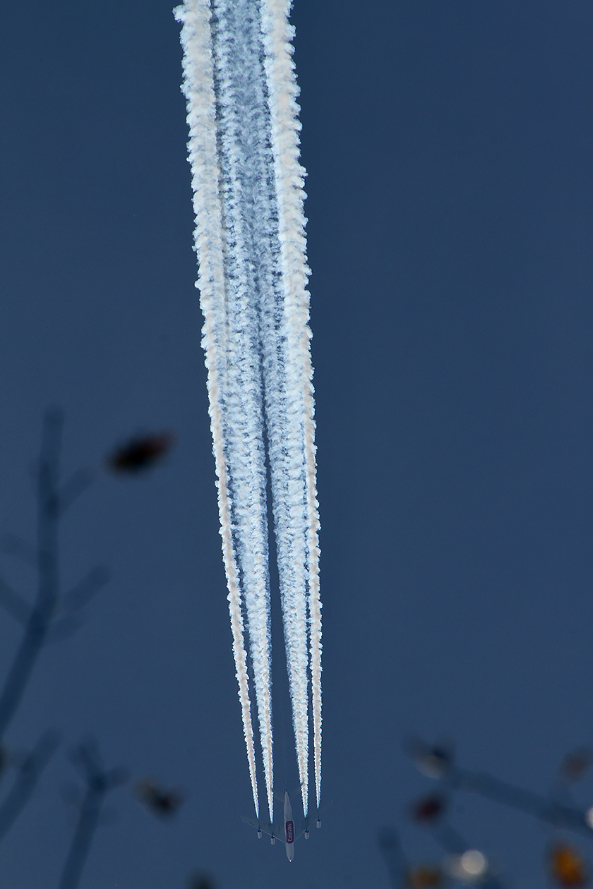
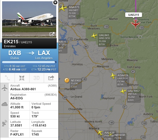
That A380:
Last edited:
deirdre
Closed Account
that 2184/2185 i love the colors in the contrails. blue and 'brown'. nice shots.Thanks, I've put all my Yosemite contrail shots here:
https://www.flickr.com/photos/metabunk/sets/72157660809505650
Yeah, kind of ties in with the blue/red contrail thing. Seems related to density as "red" spreads out into "blue".that 2184/2185 i love the colors in the contrails. blue and 'brown'. nice shots.
Yes it is.Today, I was working in Camarillo, CA, a little east of the Naval Base Ventura County, it looks like it's getting ready to land. I didn't know they put these set-ups on prop planes. I think it's a Grumman E-2 Hawkeye.
View attachment 16540
https://en.wikipedia.org/wiki/Northrop_Grumman_E-2_Hawkeye
deirdre
Closed Account
This one kinda looks like a plane in flight. But it was just a contrail sitting there persisting.
add: hhmm...wondering if it is this little dark contrail from my first stop. the shadow pics and this one were at 4:20 pm, then i stopped in roughly same area to try and get a UFO pic (dont ask) and saw the two toned contrail above. at 4:58pm. (maybe not though)
Last edited:
Graham2001
Active Member
Contrail photographed on a recent trip to Adelaide, South Australia. Taken in the Rundle Mall at about 4:30 in the afternoon local time. This was the only contrail I saw during the trip.

Trailspotter
Senior Member.
Christmas Eve contrail: AAL41 Boeing 767 is heading to Chicago from Paris at 32,000 ft

The photo was taken 15 minutes after the sunset on the ground.
The photo was taken 15 minutes after the sunset on the ground.
PeteSYD
Member
I know that multiple contrails making crosses and hatches are commonplace in some parts of the world, but in Sydney this formation is vanishingly rare. Taken on 05 December 2015. One contrail is from a Singapore Airlines 777-300ER flying SIN-AKL, the other is United 99, a 787-9 flying MEL-LAX.
derwoodii
Senior Member.
yes, its a surprise to find trails above an OZ capital city you'd think not much there but once you look a few travel from A to B
i saw this last week plane and trail lite up like comet by setting eve sun high south over port Phillip bay but pondered what and where to the get home and trace it origin

i saw this last week plane and trail lite up like comet by setting eve sun high south over port Phillip bay but pondered what and where to the get home and trace it origin
View attachment 16950
I know that multiple contrails making crosses and hatches are commonplace in some parts of the world, but in Sydney this formation is vanishingly rare. Taken on 05 December 2015. One contrail is from a Singapore Airlines 777-300ER flying SIN-AKL, the other is United 99, a 787-9 flying MEL-LAX.
Some "Xs" are an illusion, but these planes actually crossed pretty close to each other. According to the playback on Planefinder.net they passed within about 1.3km, and the vertical separation was only 1,025 feet (UA99 was at 32,975ft, SQ298 was at 34,000ft).
First proper spreading contrails I've seen for quite some time this morning. So far this winter it's been either total overcast (most of the time) or deep blue sky and cumulus (rarely).
Shortly after sunrise, looking towards London through the chilli plant... also spot the plane on approach to LHR:

And an hour or so later, getting on the train (not the same trails of course)

It would have been a good morning to do a time-lapse if I had the kit and the time. Lots of short trails mixed in with the long ones.
Shortly after sunrise, looking towards London through the chilli plant... also spot the plane on approach to LHR:
And an hour or so later, getting on the train (not the same trails of course)
It would have been a good morning to do a time-lapse if I had the kit and the time. Lots of short trails mixed in with the long ones.
Trailspotter
Senior Member.
Not as good in my areaIt would have been a good morning to do a time-lapse if I had the kit and the time. Lots of short trails mixed in with the long ones.
 There is a high cloud layer, which is thin enough for the Sun and an occasional spreading trail being seen through:
However, there are a couple of blue patches in the sky, one in the South over the London area and one in the north, over the Wash.
Trailspotter
Senior Member.
Surprise visit
I did not know that our local airport is capable of taking a B747, but it's just done it:


I did not know that our local airport is capable of taking a B747, but it's just done it:
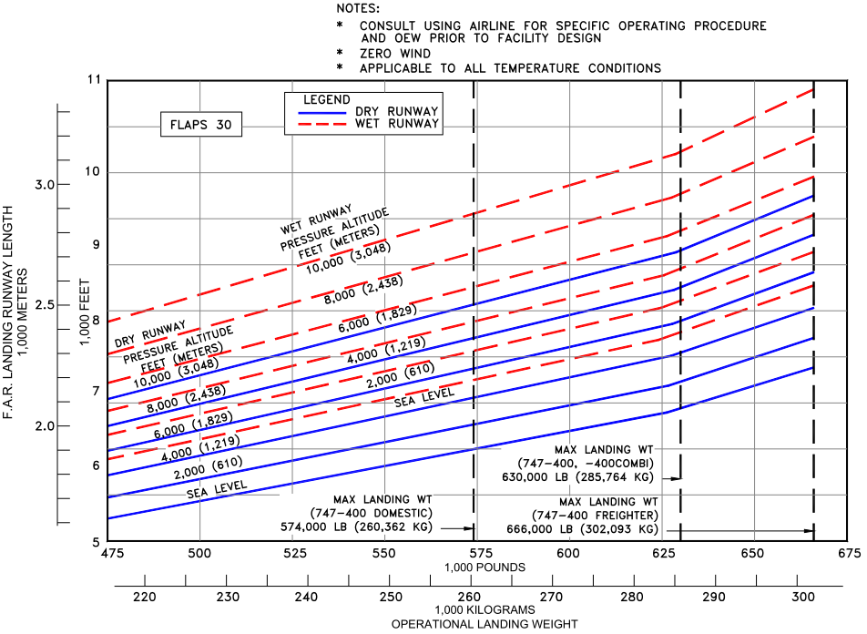
I wouldn't have thought that was the case either! Apparently the runway is 6,447ft long. Looks like at sea level on a dry runway it's just about long enough for the max landing weight of a 747-400.Surprise visit
I did not know that our local airport is capable of taking a B747, but it's just done it:
If they nail the landing!
Looks like the jumbos are maintained at CBG?
http://www.cambridge-news.co.uk/INC...ge-Airport/story-22821258-detail/story.html#1
External Quote:An airport spokesman said: "We have had Boeing 777s at the airport many times before, and in fact aircraft bigger than that, Boeing 747s – jumbo jets.
"In the 1940s, 50s and 60s, we carried out maintenance on large aeroplanes such as the Vickers Valiant and VC10, and in the 1960s, began work on the RAF's Hercules fleet.
"In 1982, we began servicing TriStars for the RAF, which are about the same size as a Boeing 777, and in the 1990s, Boeing 747s.
"Whenever a large aircraft comes in, we use traffic lights to halt the trafifc because of the aircraft's wake, turbulence which can affect cyclists on the ground."
He said aircraft coming in to land always followed a three degree glide path, and that large ones often appeared much closer to the ground than they actually were.
The spokesman added: "The arrival of these bigger aircraft is part of the maintenance contract work we have, on which many jobs depend."
I saw an extremely thick and persistent trail from a plane heading east as I was going to work, while two planes crossing just to the right of the trail were only leaving very short trails. I was on my bike and running late so unfortunately couldn't stop take a photo but it was quite a striking contrast. I just used the FR24 playback and the thick trail was also from an unusual visitor (and rather low).


http://www.ukserials.com/image_view.php?a=32582&s=zz331.jpg
It looked like a classic "chemtrail" and it really was a tanker: a refuelling tanker.")
The other two planes leaving short trails, shown near Woking, were more regular Airbuses, an EasyJet A320 and a Thomas Cook Scandinavia A330, at 35,000 and 39,000ft respectively.
Edit: it has now landed, and it turns out it was heading for RAF Akrotiri, one of the British sovereign air bases in Cyprus. Probably something to do with Syrian operations.

From the times and altitudes on the playback, I think it was contrailing at around 26,000ft this morning.
http://www.ukserials.com/image_view.php?a=32582&s=zz331.jpg
It looked like a classic "chemtrail" and it really was a tanker: a refuelling tanker.
The other two planes leaving short trails, shown near Woking, were more regular Airbuses, an EasyJet A320 and a Thomas Cook Scandinavia A330, at 35,000 and 39,000ft respectively.
Edit: it has now landed, and it turns out it was heading for RAF Akrotiri, one of the British sovereign air bases in Cyprus. Probably something to do with Syrian operations.
From the times and altitudes on the playback, I think it was contrailing at around 26,000ft this morning.
Last edited:
Trailspotter
Senior Member.
Looks like the jumbos are maintained at CBG?
http://www.cambridge-news.co.uk/INC...ge-Airport/story-22821258-detail/story.html#1
External Quote:…in the 1990s, Boeing 747s.
Yes, this jogged my memory. I recall seeing a very big plane, approaching the Cambridge airport from the south, on my way to work in mid-90s. I was not interested in planes much at the time, but it was the biggest plane of all that I saw landing there, for many years afterwards. Until today.
PS It appears that there was a recent B747 landing in Cambridge in October 2015, but the last one before that was ten years ago.
Last edited:
Trailspotter
Senior Member.
The plane is still there, neatly tucked beside a hangar:Surprise visit
I did not know that our local airport is capable of taking a B747, but it's just done it:
View attachment 17051
View attachment 17052
And its name sounds suspicious
 Was it a Tinker Bell spraying fairy dust, a.k.a. flying coal ash?
")
Last edited:
That makes it look like it's got a wing inside the building. But it's just this:
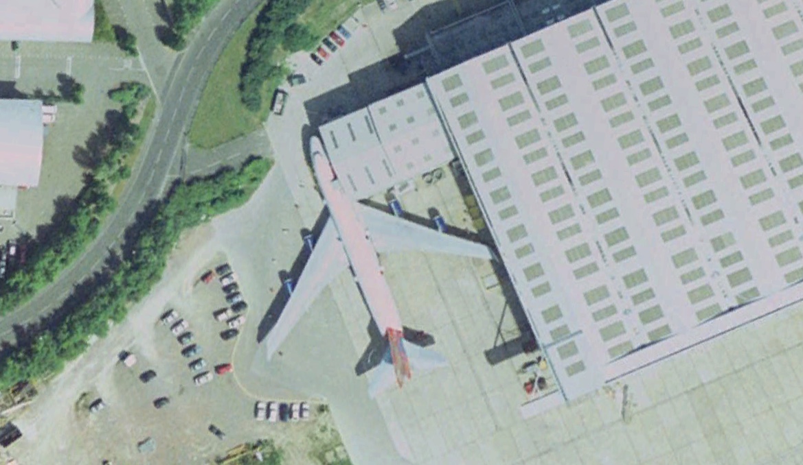
Here (at right) is a plane flying towards its own contrail.

I noticed the curved trail in the distance just before sunset and saw that it was BA94 making a turn over south Wales. The trail ended as it descended through about 29,000 feet.

25 minutes later the same flight had passed overhead, then turned back to the west to make an S-shaped approach to Heathrow.

Edit: one hour after I first saw the trail (and half an hour after the plane landed), it's spreading out into long streamers to the south.

I noticed the curved trail in the distance just before sunset and saw that it was BA94 making a turn over south Wales. The trail ended as it descended through about 29,000 feet.
25 minutes later the same flight had passed overhead, then turned back to the west to make an S-shaped approach to Heathrow.
Edit: one hour after I first saw the trail (and half an hour after the plane landed), it's spreading out into long streamers to the south.
Last edited:
Formation flying

Actually three miles apart, according to FR24 (compass was a bit off).

Actually three miles apart, according to FR24 (compass was a bit off).
Trailspotter
Senior Member.
The SIA321 A380 contrail is casting shadow near Langkawi Island in the Strait of Malacca 41,000 ft below:


The contrail shadow provided an opportunity to verify both location and altitude of the plane. At the time of photo (09:11 UTC) the Sun heading and elevation at this location were 246° and 31°, respectively. For 41,000 ft = 12.5 km this gives the distance of 20.8 km to the track projection along the heading, which is close to the Google Earth measurement:

The contrail shadow provided an opportunity to verify both location and altitude of the plane. At the time of photo (09:11 UTC) the Sun heading and elevation at this location were 246° and 31°, respectively. For 41,000 ft = 12.5 km this gives the distance of 20.8 km to the track projection along the heading, which is close to the Google Earth measurement:
Last edited:
M Bornong
Senior Member.
Emirates flight #216, LAX to DXB, looks like I may have caught some aerodynamic contrails as it passed over Bakersfield.

Behind it, it left this distrail as it passed through the cloud level.

3 minutes later, the distrail became holes in the clouds, with the contrail drifting at a slightly different speed than the cloud layer.


Behind it, it left this distrail as it passed through the cloud level.
3 minutes later, the distrail became holes in the clouds, with the contrail drifting at a slightly different speed than the cloud layer.
Last edited:
Some interesting patterns being drawn this morning as I waited for my train.


This was the flight just passing through the centre of the X:

That's a brand new plane which was only delivered from Boeing last week: http://boeing-test-flights.blogspot.co.uk/2016/01/ei-foe-b737-8as-ryanair-delivered.html?m=1

This was the flight just passing through the centre of the X:
That's a brand new plane which was only delivered from Boeing last week: http://boeing-test-flights.blogspot.co.uk/2016/01/ei-foe-b737-8as-ryanair-delivered.html?m=1
cloudspotter
Senior Member.
New routes from the LAMP airspace changes @Trailblazer ?
https://www.metabunk.org/airspace-change-to-go-live-uk.t7270/
https://www.metabunk.org/airspace-change-to-go-live-uk.t7270/
I hadn't seen that. From a quick reading of the main changes I don't think any of these flights would have been directly affected. Flights to and from LCY are generally too low to leave contrails here. Departures from Stansted are sometimes high enough to begin contrailing as they pass over. The majority of the trails I see here are from transatlantic routes, and those between Irish and northern UK airports and Europe.New routes from the LAMP airspace changes @Trailblazer ?
https://www.metabunk.org/airspace-change-to-go-live-uk.t7270/
cloudspotter
Senior Member.
I hadn't seen that. From a quick reading of the main changes I don't think any of these flights would have been directly affected. Flights to and from LCY are generally too low to leave contrails here. Departures from Stansted are sometimes high enough to begin contrailing as they pass over. The majority of the trails I see here are from transatlantic routes, and those between Irish and northern UK airports and Europe.
It'll be interesting to see just what affect the changes do make
Gridlock
Senior Member.
Busy day for the Chemtrail conspiracy yesterday, I had at least 5 'black smokers' go over around sunset (funnily enough).


I really should get a tripod, I'm a bit wary of sticking a telephoto lens out my window though and I have no garden.
I think that flight is either Lufthansa LH412 (A330-300) or easyJet U27123 (A319). 1647GMT 4th Feb taken from Aylesbury at bearing of around 240deg.
I really should get a tripod, I'm a bit wary of sticking a telephoto lens out my window though and I have no garden.
I think that flight is either Lufthansa LH412 (A330-300) or easyJet U27123 (A319). 1647GMT 4th Feb taken from Aylesbury at bearing of around 240deg.
Trailspotter
Senior Member.
I was in Playa del Ingles, Gran Canaria in January. It was around +25 C during my visit. At the same time it was -30 C home in northern Sweden. Took photos of sunrise in the morning around 07:55 GMT. Canary Islands have same timezone as UK.
The two first photos is from an unknown flight.
2016-01-09 07:46

2016-01-09 07:51

The rest of the photos is LAN Airlines LA700 from Sao Paulo to Milan. Boeing 787-8 Dreamliner.
2016-01-13 08:01

2016-01-13 08:02

2016-01-13 08:03

2016-01-13 08:04

2016-01-13 08:08

2016-01-13 08:10 The building is Templo Ecumenico.

2016-01-20 08:17

2016-01-20 08:17. Here I switched to manual exposure.

A photo of CC-BBC, one of the planes that fly LA700.
http://www.jetphotos.net/photo/8166626
The two first photos is from an unknown flight.
2016-01-09 07:46
2016-01-09 07:51
The rest of the photos is LAN Airlines LA700 from Sao Paulo to Milan. Boeing 787-8 Dreamliner.
2016-01-13 08:01
2016-01-13 08:02
2016-01-13 08:03
2016-01-13 08:04
2016-01-13 08:08
2016-01-13 08:10 The building is Templo Ecumenico.
2016-01-20 08:17
2016-01-20 08:17. Here I switched to manual exposure.
A photo of CC-BBC, one of the planes that fly LA700.
http://www.jetphotos.net/photo/8166626
I was in Playa del Ingles, Gran Canaria in January. It was around +25 C during my visit. At the same time it was -30 C home in northern Sweden. Took photos of sunrise in the morning around 07:55 GMT. Canary Islands have same timezone as UK.
The two first photos is from an unknown flight.
2016-01-09 07:46
View attachment 17437
2016-01-09 07:51
View attachment 17438
It's difficult to get an idea of the direction of the photos, but could the first two also be of LAN 700?
There is few flights in the direction from South America to Europe at that time. The odds for it to be LAN 700 is good.It's difficult to get an idea of the direction of the photos, but could the first two also be of LAN 700?
View attachment 17455
Trailspotter
Senior Member.
One more example of using the contrail shadow to verify the plane's location and altitude (see #749 above in this page).
The contrail shadow from SIA308 Boeing 777 touches the Black Sea coast at Romania, near the border with Bulgaria:


At the time of photo (12:10 UTC) the Sun heading and elevation at this location were 207° and 26°, respectively. The distance from the shadow's tip to the track projection along the heading is about 23 km (76,000 ft), which gives the calculated altitude of 37,000 ft (less than 3% difference from the recorded altitude of 36,000 ft).
The contrail shadow from SIA308 Boeing 777 touches the Black Sea coast at Romania, near the border with Bulgaria:
At the time of photo (12:10 UTC) the Sun heading and elevation at this location were 207° and 26°, respectively. The distance from the shadow's tip to the track projection along the heading is about 23 km (76,000 ft), which gives the calculated altitude of 37,000 ft (less than 3% difference from the recorded altitude of 36,000 ft).
Last edited:
Similar threads
- Replies
- 10
- Views
- 2K
- Replies
- 16
- Views
- 1K
- Replies
- 3
- Views
- 1K
- Replies
- 8
- Views
- 2K
- Replies
- 92
- Views
- 16K
Latest posts
-

-

-

-

-
Raytheon's Multi-Spectral Targeting Systems
- Latest: RobertBillyBob