Late to the party as I was linked here from another forum. But I am curious if any experts here have any insight on how best to explain to the scientifically illiterate masses why GeoResonance et. al. are bunk, while the Inmarsat Doppler analysis is not. To the average lay person both sound equally like magic (according to Clarke's third law), so is there anything specific about GeoResonance's claims that the media might not be reporting on that can be shown to and understood by the average Joe that differentiates them from the Inmarsat claim bunkwise?

You are using an out of date browser. It may not display this or other websites correctly.
You should upgrade or use an alternative browser.
You should upgrade or use an alternative browser.
Debunked: Exploration company "Georesonance" believes it may have found MH370
- Thread starter derwoodii
- Start date
David Coulter
Senior Member.
Late to the party as I was linked here from another forum. But I am curious if any experts here have any insight on how best to explain to the scientifically illiterate masses why GeoResonance et. al. are bunk, while the Inmarsat Doppler analysis is not. To the average lay person both sound equally like magic (according to Clarke's third law), so is there anything specific about GeoResonance's claims that the media might not be reporting on that can be shown to and understood by the average Joe that differentiates them from the Inmarsat claim bunkwise?
I think you need to go back through the discussions to see all the evidence. You can also look at the summary points on the home page.
The Doppler effect is a well established and understood phenomenon that can be quantified using scientific measurements you will find in any physics text book. Inmarsat is a well established and respected company that has real scientists and engineers working on the analysis. They have documented exactly how they have come to the conclusions they did, and have been open and honest about refinements that have modified initial analyses.
The Georesonance "science" is flawed from a physics perspective based on published and well established principles of the propagation of electromagnetic radiation in water (or solid ground, as their claims for finding oil or metals underground can't work either). The company uses a lot of scientific sounding terminology but the end-to-end physics they claim to use can not be verified by looking them up in a text book. The 47 "scientists" Georesonance claims to have working on the problem have never been identified or even seen in interviews conducted at the Georesonance office. There is an entire web of companies that make similar claims for oil, gas, and mineral exploration and they all seem to tie back to organizations and people in Ukraine that have been discredited by the scientific community. This web of companies and the methods they use are known to be fraudulent within the petroleum and mining communities. Georesonance claims to have "proprietary" approaches that they can not disclose even though other companies claim to use the same fraudulent approaches and have disclosed the methodology. Reputable authorities such as the ATSB have declared Georesonance's analyses "junk science". And last but not least, THERE IS NO PLANE, SHIP, METALLIC JUNK, OR ANYTHING WHERE GEORESONANCE SAID IT WOULD BE!
David Coulter
Senior Member.
Agreed. Maybe minelab has an opinion on this, as their credibility is now at stake, too.
They moved their US headquarters to the Chicago suburbs a few years ago ...
http://www.minelab.com/usa/consumer/contact-us
http://www.minelab.com/usa/consumer/knowledge-base/news?article=20404
https://local.yahoo.com/info-80824576-minelab-americas-incorporated-downers-grove
I am not sure why a metal detector company's credibility would be at stake. The technology used in metal detectors is very different than what Georesonance claims. Metal detectors are just KHz range frequency domain electromagnetics, same range as is used by legitimate geophysical companies (and your local TSA officer). The company website is factual and describes the theory and limitations.
InterpreDemon
Member
Two entirely different technologies and outcomes, but I will attempt the requested lay explanation. GeoScammers alleges the ability to detect and generate images of objects made of certain substances using extremely advanced (in fact, impossible) imaging techniques to spot, identify and then locate the aircraft, whereas Inmarsat was relying upon a "polling" function in aircraft/satellite communications to try to deduce a region where the aircraft might have ended up, not detecting the presence of the aircraft where it ended up. It's the difference between finding a particular planet, say Jupiter, by looking around in the sky until you see and identify it, then once found determining its coordinates, verses knowing the orbital mechanics of the solar system, knowing where Jupiter was at some time in the past and predicting where one could point their telescope and see it at present.
We know how GeoScammers claimed to have obtained their image, but how did Inmarsat determine where we should be searching? If you think of your ordinary home WiFi, even if you are not using the access point (nothing is connected) the access point periodically broadcasts an SSID so that devices in range know it is there and ready for anybody to connect, for example your neighbors AP named "I hate you". This is why you will see the little yellow light on the AP blinking every so many seconds when there is no activity. When a device is connected, the device and the AP will periodically exchange a "handshake" (I'm here, you're here) even when no data is being requested. The ADS-B communications between the aircraft and the satellite do essentially the same thing. In the aircraft there is a central communications module that coordinates the flow of digital data from the aircraft via several radio media; VHF frequencies to ground stations which are line-of-sight, Shortwave frequencies that reach over the horizon to anywhere between two to four thousand miles and satellite, which provides service to a hemisphere but weaker at the poles. This module listens for and responds to the "SSID" identification bursts of available services, for example on shortwave (HFDL) these bursts are called "squitters" and for the most part are similar to the bursts emanating from VHF ground stations and satellites, the main difference being the time intervals. The module exchanges handshakes with all available services, chooses the primary service to be used (the one with the best and/or cheapest signal) and routes any digital traffic via that service while continuing to handshake the other services to continuously monitor their quality or availability. So basically in the case of the Inmarsat service this handshake occurred once per hour and the satellite received seven handshakes, which is how they knew the plane had continued to fly for seven hours. Even though the suicidal pilot had turned off the "data" service, he was doing that at a higher level, essentially closing his browser window and email client but neglecting to unplug the network cable, so the handshakes continued.
Now, how does that provide location information? I hear you cry. Firstly, distance from the satellite can be determined. It takes time for a handshake to occur in proportion to the distance from the satellite... the longer the distance the longer it takes the signal to travel in each direction, so just as a radar can determine range by the round trip time from the radar antenna to the target and back, so can one from the raw satellite data which fortunately they preserve for some reason. All that gets you is the distance from the satellite, not the bearing (direction), meaning you can basically draw a circle on the ground equidistant from the satellite, in this case the circle they drew based upon the final handshake. Since we know from where the aircraft departed we can safely discard the half circle to the west and concentrate on the semicircle to the east, and assuming the aircraft flew to fuel exhaustion plot two points on that semicircle, one to the north and one to the south beyond which the aircraft could not have flown... that's what got us the two arcs, north to Pakistan and south deep into the Indian Ocean.
Now the question was, which way did it go? Well, the aircraft did not first fly directly to the circle, then fly the arc north or south, what we had was essentially seven circles representing the hourly handshakes, and the relative motion of the aircraft with respect to the satellite changed between handshakes, in some cases flying toward or away from the satellite at different velocities according to the speed and direction the aircraft was flying at the time of the handshake. This relative motion causes a Doppler Effect (the familiar drop in tone heard while riding a train past a crossing bell, but at radio frequencies instead of audio frequencies) upon both the radio frequency AND the time base of the digital data bursts. If the plane is moving toward the satellite the received radio frequency deviates higher, flying away, lower. I do not know whether the satellite, in addition to archiving the handshakes, also archives data about the signal strength and frequency deviation, I suspect they must because they probably use a dynamic means of tweaking the frequency in order to maximize bandwidth at minimum error rates, but even if they do not they could also examine the timing of the digital train of pulses that comprise each data burst (think of a comb with numerous teeth missing at random)... which arrive more closely spaced when the aircraft is flying toward the satellite. Since the satellite is centered over the equator and the aircraft departed from a location about five degrees above the equator, a flight path continuing northwest out of the Malacca Strait toward India or Pakistan would have resulted in a sequence of varying relative motion at the time of each handshake very different from a course that either crossed Northern Sumatra or turned south once clear of the Malacca Strait, and since they have the hourly Doppler data they can analyze the projected courses that would have to have been flown to the north or south to generate that data sequence and determine, if not the only possible course, at the very least the course that is most plausible. For example, if the only northerly course that could have replicated the data would have taken the aircraft directly over a US aircraft carrier undetected, that would not be a plausible course to consider.
So, in the end the preponderance of the data was in agreement with a southerly course, ending at some point along the arc representing the distance from the satellite at the time of the last handshake. They further validated their hypothesis and methodology by applying the same analysis to numerous known flights to the north and south and the predicted and observed data was in agreement.
That's the best I can do for free.
Last edited:
Just to be clear, you do not need to convince me. I have read this entire thread and understand everything you say. But I have a scientific mind and I think a pretty good grasp on the concepts. Whereas the average person on the street doesn't necessarily. So I was just playing devil's advocate and trying to figure out what would be the best way to differentiate Georesonance from Inmarsat in a way that is understandable to those who don't have much scientific literacy and to whom "scientific sounding terminology" and "actual science" are virtually indistinguishable. I think of the victims' family members who reacted to the Inmarsat report with anger for coming to conclusions with "lack of evidence" as they saw it. I suppose in this case, the difference in reputation between the two companies is as good a differentiation as any. Because (again playing devil's advocate) one could argue that they haven't found a plane where Inmarsat said it would be either. That is of course ignoring the difference between being given exact coordinates and given a search area of thousands of square miles.
InterpreDemon
Member
In that case, I would say the difference between Inmarsat and GeoScammers is the difference between the roles of Le Varrier and Galle in the discovery of Neptune. Le Verrier, based upon observed perturbations in the orbit of Uranus after its discovery sixty some years earlier calculated that another planet of a certain mass and orbit must exist, told astronomers where to look for it and Galle found it right where it should have been. Turned out it was an object observed many times in the past, but nobody realized it was a planet. The point is, Le Verrier calculated where to look for it, Galle "saw" it, Inmarsat is telling us where to look for it and GeoScammers claim to have "seen" it... but not near any location the calculations say it must be.
David Coulter
Senior Member.
Just to be clear, you do not need to convince me. I have read this entire thread and understand everything you say. But I have a scientific mind and I think a pretty good grasp on the concepts. Whereas the average person on the street doesn't necessarily. So I was just playing devil's advocate and trying to figure out what would be the best way to differentiate Georesonance from Inmarsat in a way that is understandable to those who don't have much scientific literacy and to whom "scientific sounding terminology" and "actual science" are virtually indistinguishable. I think of the victims' family members who reacted to the Inmarsat report with anger for coming to conclusions with "lack of evidence" as they saw it. I suppose in this case, the difference in reputation between the two companies is as good a differentiation as any. Because (again playing devil's advocate) one could argue that they haven't found a plane where Inmarsat said it would be either. That is of course ignoring the difference between being given exact coordinates and given a search area of thousands of square miles.
Your last point is the one that is hard to explain to people. The Georesonance story is one of a fully intact aircraft sitting within a small (500m^2) precisely located box - easily verified or disproved by simple active SONAR pings. The real story is a (probably small) debris field that requires imaging SONAR to identify somewhere in an imprecisely located large box. I am still not sure why Georesonance stuck their neck out on this as it was so easy to disprove. They believe the junk science from Ukraine? They thought it would be a side story, good enough for a bit of PR but not gain huge attention? They are total hucksters and believe that bad PR is better than no PR?
bume
Member
I am still not sure why Georesonance stuck their neck out on this as it was so easy to disprove. They believe the junk science from Ukraine? They thought it would be a side story, good enough for a bit of PR but not gain huge attention? They are total hucksters and believe that bad PR is better than no PR?
Those are the kinds of questions I have tried to understand myself. We basically seem to have two competing theories here:
a) Pretty much all of this resonance stuff is done purposefully by a group of conmen who have created a number of companies, faked documents and possibly scientific credentials, and used the names of various institutions and scientists without their knowledge to advance their scam. And they likely use more photoshop than any fancy equipment they claim.
b) We have a case of misguided science so that this originates from cold war era stuff taken over by a group of (more or less serious but misguided) scientists at a university, who have first managed to sell such services and received some acceptance of other institutions and scientists within the region, and then expanded sales abroad with the help of small marketing type companies most of which have some connections to Ukraine (like Pavel Kursa). And most of those people likely actually believe the tech works.
Based on all that I have read, I'm leaning towards alternative b. After all, so far I haven't seen real evidence of faked documents or such. In fact, in my opinion, they seem to paint a pretty consistent picture of the situation.
GeoResonance took a huge risk in making a very specific claim, exact location that should be easy to check. I don't understand why they would do that if they knew that it will be proven wrong. It can't be good PR if it invalidates their claims of being able to make such finds with great accuracy and also causes the risk of their technology being exposed as junk science. Their actions are much easier to understand if they actually believed there's something to it.
At the moment though it seems that if this was just PR after all, it may have actually worked, as their tech and connections to Ukraine and those other companies haven't been properly exposed in the media. They may have actually won. But if they managed to anticipate this outcome, despite the fact of them even telling about that connection to Sevastopol by themselves before, they have a pretty good crystal ball.
And no, as far as the validity of the technology or GeoResonance's responsibility goes, it doesn't matter if they believed it themselves or not. If they are making such claims, they should know better.
bume
Member
I think of the victims' family members who reacted to the Inmarsat report with anger for coming to conclusions with "lack of evidence" as they saw it. I suppose in this case, the difference in reputation between the two companies is as good a differentiation as any. Because (again playing devil's advocate) one could argue that they haven't found a plane where Inmarsat said it would be either. That is of course ignoring the difference between being given exact coordinates and given a search area of thousands of square miles.
The problem with Inmarsat was that they didn't publish the source data on which they based their calculations to outside experts for validation. And at the same time it was made quite clear that they were calculating something that hasn't been done before that way and hence the validity of that was unproven. Plus of course in the end they failed to find it in the original search area.
This is obviously linked to the wider problem of secrecy and hiding of information that has plagued this whole search. For example, it took a whole lot of time to release the cargo manifest, apparently even to the people who tried to search whatever that contained from the ocean. And there were reports of at least Malaysia doing their own secret searches based on information they hid from others whereas knowing the official search back then was wasting resources in the wrong location. No wonder there's distrust to the official search, which in turn has helped people taking the claims of GeoResonance more seriously, as the official search cannot be trusted much more.
David Coulter
Senior Member.
Those are the kinds of questions I have tried to understand myself. We basically seem to have two competing theories here:
a) Pretty much all of this resonance stuff is done purposefully by a group of conmen who have created a number of companies, faked documents and possibly scientific credentials, and used the names of various institutions and scientists without their knowledge to advance their scam. And they likely use more photoshop than any fancy equipment they claim.
b) We have a case of misguided science so that this originates from cold war era stuff taken over by a group of (more or less serious but misguided) scientists at a university, who have first managed to sell such services and received some acceptance of other institutions and scientists within the region, and then expanded sales abroad with the help of small marketing type companies most of which have some connections to Ukraine (like Pavel Kursa). And most of those people likely actually believe the tech works.
Based on all that I have read, I'm leaning towards alternative b. After all, so far I haven't seen real evidence of faked documents or such. In fact, in my opinion, they seem to paint a pretty consistent picture of the situation.
GeoResonance took a huge risk in making a very specific claim, exact location that should be easy to check. I don't understand why they would do that if they knew that it will be proven wrong. It can't be good PR if it invalidates their claims of being able to make such finds with great accuracy and also causes the risk of their technology being exposed as junk science. Their actions are much easier to understand if they actually believed there's something to it.
At the moment though it seems that if this was just PR after all, it may have actually worked, as their tech and connections to Ukraine and those other companies haven't been properly exposed in the media. They may have actually won. But if they managed to anticipate this outcome, despite the fact of them even telling about that connection to Sevastopol by themselves before, they have a pretty good crystal ball.
And no, as far as the validity of the technology or GeoResonance's responsibility goes, it doesn't matter if they believed it themselves or not. If they are making such claims, they should know better.
I tend to agree that theory b makes the most sense. A lot of vendors of junk science that all have a Ukrainian connection. Although accepted as valid in former Soviet circles, the "science" has never been vetted or tested by western scientists through peer review. You have a "true believer" like Pavel Kursa set up shop in Adelaide and hook up with a spokesman (David Pope) who has no scientific background and believes what he is told by Kursa. Add in a Kirlian photography image that looks like and airplane (artifact or intentional hoax from the scientists in Sevastopol?) and you get a media frenzy.
As I and others have pointed out, there is a lot of strange "science" that came out of the FSU. The Soviet Union pushed a lot of students into science, engineering, and technology, probably a lot of them did not have the aptitude or intelligence for these fields. That is a recipe for pseudoscience.
Pete Tar
Senior Member
Any concrete information on this?And there were reports of at least Malaysia doing their own secret searches based on information they hid from others whereas knowing the official search back then was wasting resources in the wrong location.
bume
Member
Any concrete information on this?
At least this one (found now with a quick search): http://www.wantchinatimes.com/news-subclass-cnt.aspx?id=20140317000100&cid=1103
Pete Tar
Senior Member
Hmm, fairly sketchy basis for an accusation, and there's a lot of regional rivalry between nations going on there too.
I don't necessarily doubt they could easily be covering up something, but I'd wait to see if anything more substantial comes to light before putting too much faith in it.
I don't necessarily doubt they could easily be covering up something, but I'd wait to see if anything more substantial comes to light before putting too much faith in it.
jonnyH
Senior Member.
We basically seem to have two competing theories here:
a) Pretty much all of this resonance stuff is done purposefully by a group of conmen who have created a number of companies, faked documents and possibly scientific credentials, and used the names of various institutions and scientists without their knowledge to advance their scam. And they likely use more photoshop than any fancy equipment they claim.
b) We have a case of misguided science so that this originates from cold war era stuff taken over by a group of (more or less serious but misguided) scientists at a university, who have first managed to sell such services and received some acceptance of other institutions and scientists within the region, and then expanded sales abroad with the help of small marketing type companies most of which have some connections to Ukraine (like Pavel Kursa). And most of those people likely actually believe the tech works.
How could any scientist, even a misguided one, believe this technology works when anyone with the slightest understanding of NMR can easily identify the physical limitations and conclude that it is BS? Either there have been no scientists involved or they are complicit in the scam. How about:
c) We have a case of misguided science so that this originates from cold war era stuff taken over by a group of conmen who have created a number of companies, faked documents and possibly scientific credentials, and used the names of various institutions and scientists without their knowledge to advance their scam. And they likely use more photoshop than any fancy equipment they claim.
avox
New Member
I tend to agree that theory b makes the most sense. A lot of vendors of junk science that all have a Ukrainian connection. Although accepted as valid in former Soviet circles, the "science" has never been vetted or tested by western scientists through peer review. You have a "true believer" like Pavel Kursa set up shop in Adelaide and hook up with a spokesman (David Pope) who has no scientific background and believes what he is told by Kursa. Add in a Kirlian photography image that looks like and airplane (artifact or intentional hoax from the scientists in Sevastopol?) and you get a media frenzy.
No way that it was done by true believers.
They presented at least six Kirilian photographs that show the outline of an airplane for different materials. Before I heard about Kirilian photography I thought they only pictured vague clouds and added the fancy outlines for emphasis (but then why not use a simple line graph instead of fancy lights?).
Now I think they either photoshopped it or used a airplane model to generate the Kirilian photograph. As I understand it you should get similar pictures if you cut out the silhouette of the airplane and moisten the areas where the material is supposed to be with a brush. How can that be done by a true believer?
Add to that the inconsistencies about the amount of photographs they needed and the time it would take to examine those and it should be clear it's a scam.
bume
Member
No way that it was done by true believers.
They presented at least six Kirilian photographs that show the outline of an airplane for different materials. Before I heard about Kirilian photography I thought they only pictured vague clouds and added the fancy outlines for emphasis (but then why not use a simple line graph instead of fancy lights?).
Now I think they either photoshopped it or used a airplane model to generate the Kirilian photograph. As I understand it you should get similar pictures if you cut out the silhouette of the airplane and moisten the areas where the material is supposed to be with a brush. How can that be done by a true believer?
Add to that the inconsistencies about the amount of photographs they needed and the time it would take to examine those and it should be clear it's a scam.
Here's a screenshot of their presentation: https://www.metabunk.org/threads/de...ves-it-may-have-found-mh370.3558/#post-103544
It looks like the blobs are more vague in that than those in the published photos where plane silhuettes were added and the pics were aligned to northerly direction. I don't know how they have generated the pics showing different materials but if they use the same source data to some extent, then it wouldn't be that surprising if all of them have somewhat similar shape. Also there might be some selective bias in how the pictures were generated or chosen, even if they believed their methods were valid.
avox
New Member
Since the satellite is centered over the equator and the aircraft departed from a location about five degrees above the equator, a flight path continuing northwest out of the Malacca Strait toward India or Pakistan would have resulted in a sequence of varying relative motion at the time of each handshake very different from a course that either crossed Northern Sumatra or turned south once clear of the Malacca Strait, and since they have the hourly Doppler data they can analyze the projected courses that would have to have been flown to the north or south to generate that data sequence and determine, if not the only possible course, at the very least the course that is most plausible. For example, if the only northerly course that could have replicated the data would have taken the aircraft directly over a US aircraft carrier undetected, that would not be a plausible course to consider.
I don't think these arguments are conclusive. First of all I think their are substantial error margins attached to the distance measures and the Doppler data. Then the Doppler data normally couldn't differentiate between the southern path and a flight path that turned around exactly at the equator. AFAIK you have to take the relative changes in the satellites orbit into account to use the Doppler measurements. The INMARSAT satellite basically makes a figure-of-eight around the center of its orbit position and the North/South movement makes it possible to differentiate between a plane flying South or North. I used to be a strong believer of Keith Ledgerwood's mh370shadow theory before someone explained that to me.
As to the likeliness that any military radar observer would raise an alarm when they see civilian airplane at 30.000 feet following a busy civilian air route - I've my doubts about that, too. Especially if it shadows a regular flight.
InterpreDemon
Member
...Then the Doppler data normally couldn't differentiate between the southern path and a flight path that turned around exactly at the equator. AFAIK you have to take the relative changes in the satellites orbit into account to use the Doppler measurements... As to the likeliness that any military radar observer would raise an alarm when they see civilian airplane at 30.000 feet following a busy civilian air route - I've my doubts about that, too. Especially if it shadows a regular flight.
As I said, it is a case of voting for the most plausible route. "If the flight turned around exactly at the equator" and flying over a US aircraft carrier, even on a scheduled route and airway without leaving some digital trace are not plausible. Even the pathetic Maylay military at least had a primary target record even though they didn't notice or care at the time. Finally, Inmarsat knows the precise orbital characteristics of their satellites, I have no doubt they can not only account for those variances but actually leverage them to advantage and doubtless as they continue to analyze the raw data and refine their model to track known flights their confidence in the result will increase.
bume
Member
How could any scientist, even a misguided one, believe this technology works when anyone with the slightest understanding of NMR can easily identify the physical limitations and conclude that it is BS?
We know for a fact what the situation has been with Kirlian photography for example: http://en.wikipedia.org/wiki/Kirlian_photography
That was clearly popular among scientists within that region, especially in the 70s. And based on the pictures showing those not so young guys doing their stuff in Sevastopol with similarly aged computers and all, they may still be stuck with the state of the art thinking of the 70s.
InterpreDemon
Member
...they may still be stuck with the state of the art thinking of the 70s.
As long as they keep manufacturing vacuum tubes for my collection of antique radios that will be just fine with me.
DaveL
New Member
GeoResonance took a huge risk in making a very specific claim, exact location that should be easy to check. I don't understand why they would do that if they knew that it will be proven wrong. It can't be good PR if it invalidates their claims of being able to make such finds with great accuracy and also causes the risk of their technology being exposed as junk science.
There really is no such risk. Look in the recent news - where are the front-page stories heaping ridicule and scorn on Georesonance? Simply nowhere to be found. Their claims were announced by the media with great fanfare and very little skepticism. The news outlets must know this, and I expect they're not too keen on calling attention to the egg on their own faces. So now the news of their failure has been relegated to obscure corners of the Internet. What overall impression do you think the average consumer of news has taken away from this whole fiasco? A very positive view of Georesonance, I'd wager.
That's the way the news media work, and I wouldn't be surprised if the people behind Georesonance understand that far better than they understand the science of NMR or EM wave propagation.
David Coulter
Senior Member.
No way that it was done by true believers.
They presented at least six Kirilian photographs that show the outline of an airplane for different materials. Before I heard about Kirilian photography I thought they only pictured vague clouds and added the fancy outlines for emphasis (but then why not use a simple line graph instead of fancy lights?).
Now I think they either photoshopped it or used a airplane model to generate the Kirilian photograph. As I understand it you should get similar pictures if you cut out the silhouette of the airplane and moisten the areas where the material is supposed to be with a brush. How can that be done by a true believer?
Add to that the inconsistencies about the amount of photographs they needed and the time it would take to examine those and it should be clear it's a scam.
As I have pointed out, there is a cultural disposition in that part of the world to believe in things that are outside the scientific mainstream in the west. So you can't look at these things from a western view of science.
Here is a link from Bume on the kind of twisted logic that is common: http://www.vitava.si/home/index.php?option=com_content&view=article&id=50&Itemid=56&lang=en
I work in mineral exploration so this gets my blood boiling, but it is perfectly logical to the FSU scientists that did the work in DRC. The "Poisk geoholography" produced 77 anomalies, 8 were chosen to check ("where the occurrence of diamonds took place before") and 5 were within the anomalies "producing 62.5% accuracy". OK, so they used "the method" on satellite imagery and checked the areas that had surface disturbances from existing or historical mining. Of those 8 areas with physical evidence of mining on the surface they only identified 5 of them - I would put that at a 37.5% error of omission. Taken the other way they identified 5 areas with evidence of diamonds out of 77 anomalies - I would put that a 6.5% accuracy. Taken yet another way, given decent Google Earth imagery anyone that could recognize what a placer mine looks like would have 100% accuracy through visual analysis. But under the Soviet system is was perfectly OK (probably needed for survival) to twist the numbers to match the predictions.
David Coulter
Senior Member.
There really is no such risk. Look in the recent news - where are the front-page stories heaping ridicule and scorn on Georesonance? Simply nowhere to be found. Their claims were announced by the media with great fanfare and very little skepticism. The news outlets must know this, and I expect they're not too keen on calling attention to the egg on their own faces. So now the news of their failure has been relegated to obscure corners of the Internet. What overall impression do you think the average consumer of news has taken away from this whole fiasco? A very positive view of Georesonance, I'd wager.
That's the way the news media work, and I wouldn't be surprised if the people behind Georesonance understand that far better than they understand the science of NMR or EM wave propagation.
LOL, thus we heap justifiable ridicule here (I think scorn is not permitted). Since the only assets sent to the Georesonance target were some sub hunters from Bangladesh there is no news story. Probably worked out to the benefit of the Bangladesh navy. I assume they got a week of sea exercises at Chinese expense.
On the positive side this site did get some recognition as a legitimate skeptic venue and probably got a few new people to join that had not heard of it. I just need to brush up on chemtrails and illuminatia to post useful comments to other threads.
bume
Member
There really is no such risk. Look in the recent news - where are the front-page stories heaping ridicule and scorn on Georesonance? Simply nowhere to be found. Their claims were announced by the media with great fanfare and very little skepticism. The news outlets must know this, and I expect they're not too keen on calling attention to the egg on their own faces. So now the news of their failure has been relegated to obscure corners of the Internet. What overall impression do you think the average consumer of news has taken away from this whole fiasco? A very positive view of Georesonance, I'd wager.
That may be true, thanks to the media not doing their work that well. The thing is though, they are not in consumer business, but rather in a pretty specialized one for a limited number of potential customers. And I would expect such customers to at least perform some sort of googling which will still show all this publicity ultimately being about their failed prediction and failure to do what they have been marketing. Even more so once the plane is actually found somewhere else. And whereas there's not that much ridicule and dismissals to be found, there's certainly a whole lot more than before this episode.
bume
Member
David: do you by any chance happen to have this EAGE membership access to this:
http://earthdoc.eage.org/publication/publicationdetails/?publication=68080
It mentions "Poisk" technology and it would be interesting to know if that is about the same technology and whether it is used in a context that might make more sense.
http://earthdoc.eage.org/publication/publicationdetails/?publication=68080
It mentions "Poisk" technology and it would be interesting to know if that is about the same technology and whether it is used in a context that might make more sense.
David Coulter
Senior Member.
That may be true, thanks to the media not doing their work that well. The thing is though, they are not in consumer business, but rather in a pretty specialized one for a limited number of potential customers. And I would expect such customers to at least perform some sort of googling which will still show all this publicity ultimately being about their failed prediction and failure to do what they have been marketing. Even more so once the plane is actually found somewhere else. And whereas there's not that much ridicule and dismissals to be found, there's certainly a whole lot more than before this episode.
When looking through the web of companies they all "claim" the same successes for petroleum, minerals, water, missing ships from WWII, even 65 million year old pyramids. The claims are all internal to the web of companies; even the testimonial from a petroleum company about how Georesonance was "really on to something" (for petroleum exploration) came from a company that shares offices with Georesonance (and probably has a business relationship with them).
I have worked in mineral exploration for decades and also know a lot of people in petroleum exploration and no legitimate western exploration company takes this technology seriously. Take a look at the "references" for one of these companies at: http://www.vitava.si/home/index.php?option=com_content&view=article&id=50&Itemid=56&lang=en. (link shared by you I believe) If you were an exploration manager would you trust these references or would you utilize industry best practices exploration methodologies? I wish I could cut an paste some of the wording but think about how long you would have a job if you used any one of these as justification to the CEO to spend your exploration budget? The "pretty specialized <business> for a limited number of potential customers" is limited to either FSU governments or huckster exploration companies that are trying to dupe potential investors by using junk science.
David Coulter
Senior Member.
David: do you by any chance happen to have this EAGE membership access to this:
http://earthdoc.eage.org/publication/publicationdetails/?publication=68080
It mentions "Poisk" technology and it would be interesting to know if that is about the same technology and whether it is used in a context that might make more sense.
Same junk science. The fact it got into an EAGE session is no sign of credibility as oral sessions are not peer reviewed. In the past there was a company that had a discredited electromagnetic geophysical system and presented an oral paper at Society of Exploration Geophysicists meetings on a regular basis. A group protested to the board that the company should be rejected as an obvious and provable charlatan, but the board decided that the risk of legal action was unacceptable. This is an unfortunate aspect of "grey publication", you can pretty much stand up and talk about anything. The aspect of the issue that doesn't come out on paper is that the presentation you cite likely met with withering questions and challenges during the presentation (I have also seen authors of this kind of stuff not turn up, but the abstract still gets credited).
bume
Member
Same junk science. The fact it got into an EAGE session is no sign of credibility as oral sessions are not peer reviewed. In the past there was a company that had a discredited electromagnetic geophysical system and presented an oral paper at Society of Exploration Geophysicists meetings on a regular basis. A group protested to the board that the company should be rejected as an obvious and provable charlatan, but the board decided that the risk of legal action was unacceptable. This is an unfortunate aspect of "grey publication", you can pretty much stand up and talk about anything. The aspect of the issue that doesn't come out on paper is that the presentation you cite likely met with withering questions and challenges during the presentation (I have also seen authors of this kind of stuff not turn up, but the abstract still gets credited).
In your opinion, does that paper (and possibly other papers by the same authors and some matches with the search term "Poisk") give further indication that the authors (who I assume have at least some sort of scientific credentials) actually believe into their technology? And were there direct references to Sevastopol University or who did those authors represent?
bume
Member
Here's some talk about the problem of chemical warfare containers sunk in the black sea in the 40s:
http://eng.investukr.com.ua/get-news/733/
The first problem is finding those leaking timebombs under the silt and all. Poisk to the rescue! This time apparently mounted on boats. Said to be "proven" tech for finding all sorts of submerged objects.
http://eng.investukr.com.ua/get-news/733/
The first problem is finding those leaking timebombs under the silt and all. Poisk to the rescue! This time apparently mounted on boats. Said to be "proven" tech for finding all sorts of submerged objects.
Vittel
New Member
They don't give up
"GeoResonance adamant MH370 is in Bay of Bengal"
http://www.therakyatpost.com/news/2014/05/10/georesonance-adamant-mh370-bay-bengal/
"GeoResonance adamant MH370 is in Bay of Bengal"
http://www.therakyatpost.com/news/2014/05/10/georesonance-adamant-mh370-bay-bengal/
RobertNC
New Member
The longer it takes to actually locate the MH370 aircraft, the better it is for GeoResonance visibility. I'm guessing GeoResonance will continue to promote their claim until the MH370 aircraft is finally located. At that time, they will probably add a new "Project" to their website taking credit for helping find MH370. It's disturbing.
bume
Member
The longer it takes to actually locate the MH370 aircraft, the better it is for GeoResonance visibility. I'm guessing GeoResonance will continue to promote their claim until the MH370 aircraft is finally located.
It should be enough to check the exact location given by them to settle this. That's what they are saying too. The question is: what on earth was Bangladesh navy scouring around then? I was wondering that earlier already and GeoResonance doesn't seem to understand that either. Did they actually check that exact location with a sonar or something? Where's the news about that? All I have seen was that they were scouring somewhere and hadn't found anything so far. Their inability to publish proper info is what's keeping these claims alive at the moment.
Btw: I haven't noticed it before but GeoResonance site actually also confirms that "Each project is performed in one of the leading universities of nuclear energy". That text is visible if you go over one of the broken images about their research facilities here:
http://georesonance.com/georesonance-exploration-technology.html
Dr StrangeLove
New Member
Btw: I haven't noticed it before but GeoResonance site actually also confirms that "Each project is performed in one of the leading universities of nuclear energy". That text is visible if you go over one of the broken images about their research facilities here:
http://georesonance.com/georesonance-exploration-technology.html
I'm sorry, but there is ABSOLUTELY no way I can take a company seriously when they write this:
even if it is a typo!External Quote:Our scientists work in seven labs:
...
Nuclear Physicsy
...
 It's even more laughable when they write at the bottom of that page:
External Quote:Bringing precision to an unpredictable industry.

Last edited by a moderator:
Btw: I haven't noticed it before but GeoResonance site actually also confirms that "Each project is performed in one of the leading universities of nuclear energy". That text is visible if you go over one of the broken images about their research facilities here:
http://georesonance.com/georesonance-exploration-technology.html
You did not notice it before because it was not there. That page said "This page is under construction" as of 2014-04-30, when I took a snapshot of their site.
Other changes between that snapshot and today's site:
- The three "press releases" were added
- The address changed on some pages (but not that one) from "Level 5 · 70 Pirie Street · Adelaide" to "PO Box 10460 · Adelaide BC"
- On the "Our Projects" page, an unlinked project (Groundwater · Australia · 2009, Location: New South Wales) was removed. The description was "By request of the 'State Farmers' Association GeoResonance found groundwater stream at 28 – 36 meter depths. One borehole was drilled. The well is used by a hotel and yields ~16 ton per day."
David Coulter
Senior Member.
They don't give up
"GeoResonance adamant MH370 is in Bay of Bengal"
http://www.therakyatpost.com/news/2014/05/10/georesonance-adamant-mh370-bay-bengal/
From the story: '...What we know for sure is that our claim has unearthed numerous pseudo scientists in the form of media commentators," said managing director Pavel Kursa.'
I assume that is directed at metabunk. I guess it is better than one of the comments I got on cnn.com wherein I was called a "pea brain". I was planning on adding that to my CV.
bume
Member
You did not notice it before because it was not there. That page said "This page is under construction" as of 2014-04-30, when I took a snapshot of their site.
Other changes between that snapshot and today's site:
- The three "press releases" were added
- The address changed on some pages (but not that one) from "Level 5 · 70 Pirie Street · Adelaide" to "PO Box 10460 · Adelaide BC"
- On the "Our Projects" page, an unlinked project (Groundwater · Australia · 2009, Location: New South Wales) was removed. The description was "By request of the 'State Farmers' Association GeoResonance found groundwater stream at 28 – 36 meter depths. One borehole was drilled. The well is used by a hotel and yields ~16 ton per day."
So they have actually made some changes, like adding broken images...
I have to say that, if they did this for publicity, they certainly aren't doing too good a job in it, not in the Internet at least. This has been going on for weeks now and their site is presumably seeing traffic figures unlike ever before, and yet it's very much a work in progress still. And now they have made minor upgrades containing not just broken images but even their error page it tries to use for those missing images is not found. And if they would have read this thread or other critical sites, I would expect them to at least correct that claim about locating a ship that's still very much missing, especially if that claim is caused by an error in translation, as I suspect.
A little bit of consistency wouldn't hurt their credibility either. Especially in the way they talk about their connections to Ukraine/Sevastopol. First they talked about "their team in Ukraine" and then refused to name Ukraine. They are talking about all those projects as if they are their own, despite the fact that the company hasn't even existed at the time of most of them, and now apparently have modified their website to acknowledge that all the projects are in fact performed by a university.
Although in regard to Ukraine, it's obviously unclear who even owns that area now, so that might be a valid excuse for avoiding talking about it. Might be that their business is actually pretty much halted at the moment as their research facilities seem to be occupied by Russia. There might be even the risk of losing access to those permanently and hence their whole business may be at risk.
Last edited:
WeedWhacker
Senior Member
So they have actually made some changes, like adding broken images...
This makes it all the more interesting.....as a developing story (on its own, as it turns out)...a bit of a not pleasant association with what is a very Human tragedy, for the relatives and loved ones and friends of the passengers and crew of MH370.
I think some consideration for their feelings needs to be considered. I've never been in that type of situation.
bume
Member
NewScientist subscribers ahoy:
http://www.newscientist.com/article/mg22229691.100-feedback-detecting-a-dubious-detection.html
http://www.newscientist.com/article/mg22229691.100-feedback-detecting-a-dubious-detection.html
Pete Tar
Senior Member
Just poking around and found a nice post explaining the flaw in the claim already stated here but in a nicely detailed way. From the comments section of http://www.science20.com/the_chatter_box/mh370_why_search_teams_ignored_georesonance-135363)
External Quote:Hello Gamma,
You wrote, "... Earth's field NMR of the materials quoted by Georesonance are in the same range as ELF (extremely low) signals chosen for submarine communication, precisely because such low frequencies CAN penetrate deep seawater. There are concerns based on signal-to-noise considerations, but given that the method is claimed to have a military pedigree, technical sophisitication and ingenuity is likely to be quite high."
It won't save them. Trust me.
The strength of the geomagnetic field in the Bay of Bengal is around 44 uT. At this field strength the Larmor frequency is on the order of 2 kHz and so, yes, the frequency of an EFNMR signal at that location falls within the ELF band. And yes, the ELF band is used for (one-way) submarine communication because of its ability to penetrate seawater somewhat, the useful depth depending on the particular frequency used.
The ELF frequencies used by the U.S. and Russia are both under 100 Hz. The U.S. used a frequency of 76 Hz and Russia, 82 Hz. Yet even at these extremely low frequencies the useful depth in seawater is limited to around 200 metres or so. According to Google Earth, the depth at the 'wreckage site' claimed by GeoResonance is around 660 metres, roughly three times deeper than the depth at which a much-lower frequency (by two orders of magnitude) is detectable by the latest state-of-the-art military receivers. Moreover, 660 metres for the depth at the wreckage site is conservative given that some sources are quoting up to 1100 metres' depth at that location.
Because of its high conductivity seawater strongly attenuates EM radiation. The higher the frequency, the more pronounced the attenuation. How much? Let's look at the numbers:
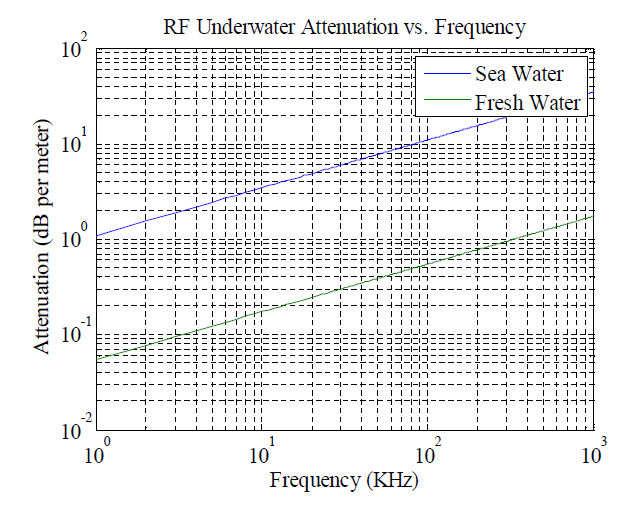
For a 2 kHz signal the attenuation is around 4.9 dB/meter. Multiplying that by the depth gives us a net attenuation of 3226 dB! So what does this mean?
What it means is that for every 3 dB of attenuation the signal strength decreases by half. Another 3 dB attenuation, half again, and so on until we've halved the original signal 3226/3 ~ 1075 times. In other words, by the time that signal has traveled through 660 metres of seawater its strength is, for all practical purposes, zero. No amount of ingenuity now or in the forseeable future will be able to detect such a signal. Nor is this their only problem. It gets worse.
GR claims to have identified the composition of various materials at the 'wreckage site,' some materials inside what they're guessing is an aluminium fuselage and wings. Copper, for instance, suggesting copper wire. Now, even if they were using EFNMR and even if they were sitting on the very fuselage itself, they would not detect anything inside. Not using EFNMR they wouldn't. Why not? Basic physics: what is an aluminium fuselage to a radio wave originating inside? A Faraday cage?
Most of us have a Faraday cage sitting on our kitchen counters: a microwave oven. The one in my kitchen is an 1100-watt unit. It is so effective as a Faraday cage that, in spite of the power levels inside, scarcely enough leaks out to pose a hazard. The same principles apply to a 2 kHz EFNMR signal - a very weak signal to begin with, even under ideal circumstances - originating inside a metallic aircraft fuselage. You'll never see it, even if you were there at the wreckage site directly. One might object, "But what of the windows? Won't it leak it out those?" No, and for the same reason it does not leak out the little holes in the window of a microwave oven: the holes are too small for the wavelengths in question.
These same problems apply to detecting hydrocarbons indicative of jet fuel, jet fuel presumably still in the tanks? If those tanks contain jet fuel, then they're not leaking, and if they're not leaking, then they must be intact, yes? And assuming they are intact, those tanks are also Faraday cages, very good ones in fact. Nor are these their only problems. It gets worse.
That EFNMR instrument must actually be there, on site to ping the sample with an EM pulse in order to get that telltale 2 kHz signal. In the case of GR's claims of having detected copper and jet fuel, that pinger has to be inside the fuselage and inside the fuel tanks where the signal is. As far as I know GR hasn't so much as dipped their toes in the water, much less sent hardware to the bottom to collect their data (and if so, where are the photos?). Those materials are not going to radiate 2 kHz signals all by themselves, and pinging them from the surface will have the same problems with attenuation as we discussed earlier, even if it were practical.
Given these obstacles, GR could not have used any form of NMR to identify the composition of that wreckage through 660 metres of seawater. They would have to be magicians, magicians able to bend the laws of Physics and, if they are magicians, then this raises other questions as well. For instance:
If GR can remotely detect aircraft wreckage at the bottom of the sea with such clarity and to such an extent as to actually identify the composition of materials in that wreckage, then why aren't the world's militaries clamoring for their technology to detect and ID submerged submarines - most which operate at much shallower depths than that at which this presumed wreckage lies? Governments have spent hundreds of billions on ways to locate The Other Sides's subs and would they pass up the chance to acquire such a marvelous technology as GR claims they possess? Hopefully before the Other Guys do?
Why aren't GR using their technology to locate valuable mineral and hydrocarbon deposits and securing these tenements for their own gain? Oil? Diamonds? Gold? Platinum? Uranium? According to their website they've found them all. Are GR in business for purely altruistic reasons?
"Here, Chevron, for a small fee how's about we find you a billion-dollar patch of oil somewhere so that you can get rich off our efforts? Waddayasay? (oh, by the way, we're not in it for the money)."
So many things about GR's claims make no sense. It all smells so fishy that even my cats are interested!
Best,
Tex
—
"I was going to change my shirt, but I changed my mind instead" -- Winnie the Pooh
Tex Pepper | 05/15/14 | 03:50 AM
David Coulter
Senior Member.
The latest PR from GR. They have taken to ranting and threatening slander lawsuits....
http://georesonance.com/20140521 Press Release.pdf
http://georesonance.com/20140521 Press Release.pdf
External Quote:
Press Release
May 21, 2014
Today marks 8 weeks since a characteristic anomalous zone in the Bay of Bengal was discovered in our research facility.
At GeoResonance, we fly Malaysia Airlines to our destinations in the Asia Pacific region, and the tragedy of MH370 deeply touched us. What started as a project to locate the missing aircraft turned into an emotional journey for the GeoResonance team. GeoResonance would like to thank those in the scientific community who applied their knowledge and passion to contribute to the search for the missing MH370.
On the 7th of May GeoResonance was contacted by the satellite communications scientists from the University Putra Malaysia (UPM), who had discovered the GeoResonance findings correlated with their calculations. The UPM scientists also believed that the northern corridor was unfairly dismissed from the search and asked the authorities to review and share the raw satellite data. However the request fell on deaf ears and was ignored by the authorities.
It is unfortunate for the world community that some public servants prefer to discredit and discard an alternative point of view, rather than investigate and act upon it. As an example, bureaucrats in some Australian Government departments ignored all GeoResonance requests to sit through a technical briefing on the technology. Instead, they chose to make uneducated slanderous statements. These individuals act as though they are immune to the laws of the land regarding defamation, they will discover they are not.
GeoResonance has been informed by sources quoting the Malaysian and Australian Governments that the precise location identified by GeoResonance in the Bay of Bengal, contrary to reports, has not been searched by the Bangladesh Navy and will not be as the JACC are certain MH370 is in the Southern Indian Ocean. This is very
disappointing as GeoResonance stands by its claim of discovering what appears to be the wreckage of an aircraft. GeoResonance does not and has never claimed this is MH370, simply a lead that should be followed up.
Fortunately, time works against the bureaucrats. In the last month, scientists from all over the world have been casting shadows over the assumptions that see the International search team operating solely in the Southern Indian Ocean:
• May 7, 2014. "MH370: The pings were not from the black box".
We suggest those interested should read Duncan Steel's blog (http://www.duncansteel.com). Professor Steel is a brilliant scientist who has been engaging great minds from different fields to contribute to MH370 search.
Despite the fruitless search and rescue operation, GeoResonance welcomes the decision by the Malaysian Department of Civil Aviation to release the Inmarsat "raw data" for public consumption. This will allow truly independent experts to participate in the analysis which may help bring closure for the families of passengers and crew affected by the MH370 tragedy.
- May 8, 2014. "Why the official explanation of MH370's demise doesn't hold up".
- May 19, 2014. "MH370 'ping' recordings will not be released as doubts grow over their validity".
GeoResonance
Last edited by a moderator:
Similar threads
- Replies
- 92
- Views
- 16K
- Replies
- 29
- Views
- 5K