• MH370 speculation has become excessive recently. Metabunk is not a forum for creating theories by speculation. It's a forum for examining claims, and seeing if they hold up. Please respect this and keep threads on-topic. There are many other forums where speculation is welcome.

Debunked: Exploration company "Georesonance" believes it may have found MH370

- The 'people on a forum' can do better than deride real people out there actually doing something apart from typing
Do you have evidence that they are actually doing something? Do you have evidence to dispute that the claims of sensing magnetic fields of copper wire through half a mile of sea-water is scientifically impossible?
This is what we do here, critically look at a claim to establish whether it is factual or not. No we shouldn't shut up, we should look seriously at what they're saying and see if it's bunk or not.
If that's not your thing fine, but don't criticise those who see value in truth.

Not guesswork but a semblance of science behind it
Please explain to us what this science is. And also how the current search has no science behind it.
 
That is quite lame. You are crossing the skeptic line into irationality
I notice they have placed the location on a steep slope - which opens up the possibility of claiming that there was "something" there, but that it was swept away by a landslide.
 
It has nothing to do with wishing they are wrong.. but everything to do with giving people false hope @vooke .. These are people's family and friends we're talking about here, and if some jackass comes around saying HEY I KNOW HOW WE CAN FIND YOUR FAMILY... and its a publicity stunt to drum up money/notoriety or a flat out Hoax.. then its detrimental and devastating.. being WRONG about things, while painful.. is a lot easier to deal with. Thats what Pete and the others are driving at.
 
That is quite lame. You are crossing the skeptic line into irationality
If you have any familiarity with fraudsters and the excuses they come up with then this makes sense as a pre-emptive move on their part if they are faking it. They always have an exit strategy to save some face.
But it is just speculation, obviously.
 
Please explain to us what this science is. And also how the current search has no science behind it.
Semantics.

I like Egyptian pyramids. Nobody nowhere have any idea how those massive structures came into being. Supposing all we have as evidence of pyramids is drawings. The average scientist will tell you there is no possible way that structure could have been put up 5000 years ago. There was no technology. And they are right.

But unfortunately, we have massive pyramids dated 5000 years ago and we have no idea how they did it. Just because you can't answer HOW don't mean WHAT is non existent.

GeoResonance is not vague, they have a specific region,a claim so easily verifiable. Why would I knock myself out guessing how they did it before I even confirm if they are right?
 
If you have any familiarity with fraudsters and the excuses they come up with then this makes sense as a pre-emptive move on their part if they are faking it. They always have an exit strategy to save some face.
But it is just speculation, obviously.

Yes Pete,
Healthy skepticism is cool.GeoResonance went privately to the authorities as early as beginning of April with this information. They avoided sensationalism. Even now they are not shouting all over> That is a plus for them however way you look at it
 
It has nothing to do with wishing they are wrong.. but everything to do with giving people false hope @vooke .. These are people's family and friends we're talking about here, and if some jackass comes around saying HEY I KNOW HOW WE CAN FIND YOUR FAMILY... and its a publicity stunt to drum up money/notoriety or a flat out Hoax.. then its detrimental and devastating.. being WRONG about things, while painful.. is a lot easier to deal with. Thats what Pete and the others are driving at.

No. It is simply saying since we can't figure out what you are doing, you MUST be wrong

Information on #MH370 is not perfect but I would like to believe that the next thing authorities would ask for is CURRENT images of the location. West is even inventing or ascribing a ridiculously lame escape strategy for them; an underwater mudslide. The idea is to 'debunk' them even further. He is essentially calling them dumb
 
Just to add some background... I have worked in legitimate mineral exploration for over 30 years with a focus on satellite and airborne imagery. Companies like Georesonance are always trolling around the shady edges of our field. If it is not "elemental resonance" it is "microleptons" (see http://physicsworld.com/cws/article/news/2002/jul/03/oil-companys-microlepton-technology-dismissed). A common factor is that everyone involved comes from the former Soviet Union.

There are only two reasons any exploration company would use these approaches: the exploration company is totally naive and gullible or (most likely) the exploration company has worthless prospects and needs to generate false target to generate money from investors. For for legitimate but naive companies, the result they get is very large blobs that cover significant portions of their exploration area. So, if an area is highly prospective and a discovery is actually made, companies like Georesonance can claim success - if 80% of the exploration area falls under an "anomaly" then there is an 80% chance their of "success".

These fraudulent methods have not gained much traction in the mineral exploration world. Minex geologists tend to be very pragmatic and conservative; getting buy-in on any new technique, even useful and legitimate ones, is very difficult.
 
ABC Media Watch is having a look at this story and uncritical coverage in the MSM. I'd love to talk to Txt29 who I believe is in Adelaide. Or Mick West ... someone who can give us a short upsum of what was wrong with these claims
 
As always, mathematics and numeracy but to the nearest order of magnitude point to the truth or the folly.

The highest resolution film emulsions can resolve around 40 LP/MM (line pairs per millimeter) which means that from a satellite even as close as 280 km the maximum area they could analyze on an 8x10 sheet with a resolution sufficient to resolve an object 200' long (where the entire plane would appear as a single speck under the highest contrast/lowest noise conditions) would be about 150 x 200 miles, or 30,000 square miles, and to resolve down to the five to ten foot resolution in their photos they would have to zoom in to an area of about 8 x 10 miles for each sheet.

Understand... it would still take a magnifier to see the image at all in either case. Thus, assuming they did not have prior knowledge of their suspected location and were say, sweeping the entire northern Indian Ocean and Bay of Bengal, roughly ten million square miles, they would have needed to process at least 300-400 film sheets through their flux capacitor reactor and then identify the suspect speck on one of them in order to then be able to zoom in from the satellite data or fly their black helicopter (from the fleet based inside a hollowed-out volcano) over the suspect location in order to get the high resolution data.

Further, they had to do this twice, so that they could use a subtraction process to find the before/after sheet pair(s) that had a speck afterward but not before. But wait... they actually would have had to do it a third time (total sheets now well over a thousand) in order to eliminate all the hundreds or thousands of roving maritime objects containing similar substances, so that you could find only the specks that suddenly appeared and then did not subsequently move.

They didn't think of that problem as they made up their story. Obviously they must have burned through a lot of reactor time and ink jet cartridges. And presumably they did all this on a lark, at their own time and expense without an order or contract from anybody.

But hey... if Drs. No and Evil, not to mention James Mason, can find the sums to build secret empires and infrastructures above and below the sea I imagine an empty fifth floor office suite cleverly disguised as a defunct energy exploration company could very well be the innocuous gateway to a previously unknown advanced scientific society.


[mod edited for spacing]
 
Last edited by a moderator:
Nobody nowhere have any idea how those massive structures came into being. Supposing all we have as evidence of pyramids is drawings. The average scientist will tell you there is no possible way that structure could have been put up 5000 years ago. There was no technology. And they are right.
Sorry but that does not seem correct. Pretty sure it's not some baffling mystery and there is pretty good idea how they were done. Just recently there was a discovery that they used wet sand as a surface to move the blocks along.

Let's not make this conversation about the pyramids though.
Why would I knock myself out guessing how they did it before I even confirm if they are right?
But we can establish certain things without having to go to the effort of launching an expedition (which amounts to much less than knocking ourselves out guessing how they did it), based on what they say and the evidence in their website about their technique. It makes more economical sense to query their claims according to physical science than to rush into looking where they point. If what they say about their science doesn't add up then why should they be given any further effort?
That said though maybe there's be a willing boat already in the area with some ability to scan the bottom to see if there's anything there? Do you know any ship captains?
 
No. It is simply saying since we can't figure out what you are doing, you MUST be wrong

Information on #MH370 is not perfect but I would like to believe that the next thing authorities would ask for is CURRENT images of the location. West is even inventing or ascribing a ridiculously lame escape strategy for them; an underwater mudslide. The idea is to 'debunk' them even further. He is essentially calling them dumb

The point is that Georesonance is making claims that are patently false. The light detected by multispectral imagery does not significantly penetrate water (~30m in the UV-blue and only nanometers in the IR). If the object in question can not physically be illuminated then there is no possibility of the "resonance effect" happening. And, in fact, there is no such thing as this "resonance effect". If you could detect elements using optical light (UV through IR) there would be instruments on the market to do that. In order to directly detect and measure elemental compositions you need x-rays or laser ablation, and even then the phenomenon measured is not resonance. The common instruments to do this are X-Ray Fluorescence (XRF) or Laser Induced Breakdown Spectroscopy (LIBS). Both of these require direct contact with the material being analyzed.
 
holy moly i post up a link from a news feed under MH370 speculation thread to see it bring together some great minds wisdom and research to debate its credibility & validity , a happy metabunk contributor here.
 
I like Egyptian pyramids. Nobody nowhere have any idea how those massive structures came into being. Supposing all we have as evidence of pyramids is drawings. The average scientist will tell you there is no possible way that structure could have been put up 5000 years ago. There was no technology. And they are right.

But unfortunately, we have massive pyramids dated 5000 years ago and we have no idea how they did it.
This is off topic, but, just to get you started (since it's absolutely not even close to true that scientists are as mystified by the pyramids as you say you are) http://www.livescience.com/32616-how-were-the-egyptian-pyramids-built-.html


As far as this "GeoResonance" company, it's heartbreaking to see so much of the media--completely in the dark--
act as if this mysterious business' odd and secretive statements deserve to be treated as credible.
Not surprising (especially given how desperate the media is for new angles on 370) but still sad.
 
@vooke - If you have some information which can validate this company or even prove the technology, please do so.
Bangladesh's Navy has already sent people to check it out.
I would love this mystery to be over and IF they did manage to find the plane it would be an incredible embarrassment for everyone.
I think everyone here has a right to their opinion, you included and sure debate is welcomed and even encouraged, but it seems you are not open to 'adding' anything.
All you want to do is hack the input people have contributed down, contributions people can mull over and consider for themselves.
So I ask again as @Pete Tar did, do you have anything to validate this company and their tech ?
 
Just to add some background... I have worked in legitimate mineral exploration for over 30 years with a focus on satellite and airborne imagery. Companies like Georesonance are always trolling around the shady edges of our field. If it is not "elemental resonance" it is "microleptons" (see http://physicsworld.com/cws/article/news/2002/jul/03/oil-companys-microlepton-technology-dismissed). A common factor is that everyone involved comes from the former Soviet Union.

Cool, we have an actual subject matter expert here :).

Have you ever heard about this "Deep Vision" stuff before or seen any familiar names in connection to that? Either these companies that sell it, persons involved, or those customers or projects that have been named for example in the references given here: http://georesonance.com/georesonance-geophysical-survey-projects.html

As far as I can tell this is just a variant on the same theme. Turns up under a bunch of names and companies: Deep Vision, 4D GeoSeis, TransComplex, Georesonance, etc. The common theme is the claim that using any earth imagery, they can identify the depth, size, and shape of any commodity (all metals, oil, gas, water) at depths up to 5000m under the Earth or water. I think it all comes out of a group of Soviet era "scientists" that got hooked on Kirlian photography. The Soviets also had an entire program of looking for ore deposits using psychics. There is an odd cultural attraction to the crazy ideas - I worked with a brilliant Soviet block scientist who adamantly believed in psychic powers!
 
@vooke - If you have some information which can validate this company or even prove the technology, please do so.
Bangladesh's Navy has already sent people to check it out.
I would love this mystery to be over and IF they did manage to find the plane it would be an incredible embarrassment for everyone.
I think everyone here has a right to their opinion, you included and sure debate is welcomed and even encouraged, but it seems you are not open to 'adding' anything.
All you want to do is hack the input people have contributed down, contributions people can mull over and consider for themselves.
So I ask again as @Pete Tar did, do you have anything to validate this company and their tech ?

@Andy,
I don't recall you validating all the people in the search team before believing them. Not that they are not competent. What we have here is no search for truth but set minds that GeoResonance MUST be wrong, SHOULD be wrong and then funny arguments backing that up. I thought logic don't start with a conclusion
 
As far as I can tell this is just a variant on the same theme. Turns up under a bunch of names and companies: Deep Vision, 4D GeoSeis, TransComplex, Georesonance, etc. The common theme is the claim that using any earth imagery, they can identify the depth, size, and shape of any commodity (all metals, oil, gas, water) at depths up to 5000m under the Earth or water. I think it all comes out of a group of Soviet era "scientists" that got hooked on Kirlian photography. The Soviets also had an entire program of looking for ore deposits using psychics. There is an odd cultural attraction to the crazy ideas - I worked with a brilliant Soviet block scientist who adamantly believed in psychic powers!

Yes it seems that the technology is named "Deep Vision" and it's owned and executed by Sevastopol National University of Nuclear Energy and Industry and the multitude of those companies are more or less just selling the services of Sevastopol.

When it comes to psychics and other crazy ideas, it is not just soviets but the US as well who has had more than enough of those. See for example this (active from 1970s all the way to 1995):

http://en.wikipedia.org/wiki/Stargate_Project

I also remember reading about one US army project where they had wasted a whole lot of money in investigating whether destroying an image of soviet missile can destroy the missile itself.
 
As far as I can tell this is just a variant on the same theme. Turns up under a bunch of names and companies: Deep Vision, 4D GeoSeis, TransComplex, Georesonance, etc.

Interesting new twist:

https://au.news.yahoo.com/sa/video/watch/23162104/reasoning-behind-dismissed-theory/

So there's not just a dismissal but also another Canadian company expressing their support and claiming to be using something similar:

http://www.leafandstone.ca/

I didn't immediately find clear connections to Ukraine. Have you heard of that company and can you take a look at if what they are saying makes sense?
 
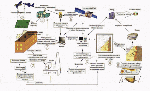
The more I see, the more absurd it is. You take any of their sentences, any fact, any word from their presentations, and it is all so absurd that your jaw just drops, and you can't even argue. Let's take it step by step:

1) First they take aerial photographs by satellite and by plane.

- They tell that their satellite photos are 60x60km. At 2,000,000 km² that they tell they searched, that could not be done in just couple of orbital passes at this resolution, and with such a low orbit. More likely couple of hundreds of orbits. And all that they allegedly did at least twice.
- As for the plane, I really do not see how they could search the area in such a short time and without anyone knowing about it, and how they could fund it.

2) They then take the multispectral satellite photographs and print them onto gelatin layers and bake a hologram from it. That's also absurd and the spectrum, even if it was full, can contain only surface reflection. They do not speak about laser excitation at this stage, and it would not be imaginable anyway that they could zap 2,000,00 km² with a high powered laser within a day or two as they claim, and without militaries in that area noticing it.

3) The holograms are then processed in the nuclear reactor (#2 on the diagram). Another incredible absurdity. The alpha and gamma rays they show cannot extract any information from a hologram printed from digital satellite data that is not in the original data.

4) Then the hologram baked by the radiation is passed to the Kirlian kamera (#3 on their diagram) that miraculously extracts from the surface data all material spectra deep beneath the surface with the precission of 1.5 ppm as deep as 5000m. It can't be more absurd.

So, bume, please stop thinking one single second that there could be some truth on any of their claims. There is no way it could work. Rather than this, I'd believe more that the Moon and Mars are made of platinum, gold and diamands, that the Earth is hollow, and that there are 65 millions years old pyramids in Crimea as Mr. Gokh, the ultimate guru of GeoResonance, writes.

This is the schema of their process from their documentation.

The description in in Cyrilic, so if you need to translate something just ask, but I am lazy to translate all the crap now.
gokh.gif

As to vooke's comments:
The claim is dubious, check it out. How much would it cost to dash there and do this? a fraction of how much they are currently burning per day. What do they stand to lose by checking it out
They did send boats to verirfy it, but it does cost a lot of money of course, and it will end up costing more if they lend any more credibility to the claims of GeoResonance. There will be nothing, or perhaps an known old wreck on that location, so they will have to search a broader area. But that would be still acceptable if they were not pressed to verify all the finds made by Courtney Love, by thousands of clairvoyants, and by all the conmen. It they followed each lead of every madman in the same way, it would all cost an order more than it currently does.

-Yes you are right it is undecided, which means guys should shut up instead of fishing junk on GeoResonance. You have even called it a publicity stunt.
This website was built to debunk diverse claims of fraudsters or diverse confused people by presenting facts. If you or the GeoResonance finds any of the facts or evidence presented here incorrect, they are free to present their evidence to support their claims.

-If it turns out to be false, they lose even the little business they have. They lose their face completely. Why would they do this?
-Australian companies lose face. Nobody can tell the genuine from jokers there
Unfortunately it is well established fact that there is no such thing as bad publicity. Their brand was presented worldwide by all possible media from the biggest ones like Reuters, CNN, etc. to the smallest local newspapers. Hundreds of millions of people know about the company now. The brand, the domain name, and all the stir, regardless how much they ridicule themselves in the end, is now possibly worth of millions. Before the affair is completely discarded (which they can successfully delay for a long time) will take weeks or months, and in the meantime they may and probably will defraud investors of huge amounts of money.

Besides it, they created a new identity (GeoResonance) just for this event. As shown on the first page of this thread, their website was created in April 2014. They can simply sell the brand to some spammer or a porn company who'll be more than happy to have such known brand, and they'll continue robbing investors under the myriads of identities they use (or they'll create a new one).
 
Last edited:
Well anyway someone's checking the area, so that's good, as long as it's not a waste of vital resources.

http://bdnews24.com/bangladesh/2014...ngal-again-for-mh370-after-georesonance-claim
Bangladesh Navy has mounted a renewed search for the missing Malaysia Airlines flight MH370 in the Bay of Bengal after an Australian exploration company claimed to have traced its debris.
Content from External Source

I hope that no more resources are put into this wild goose chase than a couple ships from the Bangladesh navy (you don't see India chomping at the bit to investigate). Since a theoretical intact aircraft (unlike an anachoic coated sub) will return an active sonar ping like a mirror it should take no more than a couple of passes over the very precise location provided by Georesonance. However, my skeptical side says there will be all kinds of "explanations" about the lack of the fictitious aircraft. Hopefully the special mission is good for Bangladesh in that some entity paid for anti-sub training on the high seas.
 
Last edited:
http://www.leafandstone.ca/
I didn't immediately find clear connections to Ukraine. Have you heard of that company and can you take a look at if what they are saying makes sense?
A quick search in the Canadian business registry does not show any record under their name. They seem to be just another snake oil company, and using the momentum to gain some publicity too. Similarly as GeoResonance they tell they use commercially available spectral satellite images (they do not own any satellite), and extract the subsurface spectral maps from them. They do not explain how, and why the satellite company that sells them the spectral images does not sell the information to end customers directly. The pointer to the probable fraud in this case is that they need a sample of oil from the explored area, so that they can perform their "resonance analysis". That is an absolutely absurd BS. Of course, when they have a sample, they know the oil is there, so they can give the customer whatever map they invent. Since they do not guarantee any depth, and tell the customer still needs to perform seismic probes, they cannot get wrong. If the customer drills and finds nothing, they can tell him he just did not drill deep enough.
 
Last edited:
So, bume, please stop thinking one single second that there could be some truth on any of their claims. There is no way it could work.

Don't worry, I'm highly skeptical of their claims for several reasons, but I'm just interested in digging the truth out of this all, if not else but just for the fun of it :).

It's not my area of expertise and I have nothing at stake here, and so I don't want to make strong judgments on subjects I don't properly understand or accuse them of being scam artists if I can't prove it. For me it's not just about finding out if this is bs or not but also about finding out if we can sort of beat the media in getting to the bottom of this through this remote sensing on the web :). It certainly seems that once again the journalists are way too lazy to find out stuff we already know. There's already a subject matter expert and someone who can read cyrillic text on this forum. Both skills that most journalists don't have and are apparently too lazy to consult the experts.

Also in regard of accusing GeoResonance and others of scamming people, that Canadian company has a bit surprisingly linked to a document about "voodoo" geophysics on their site with the title "There's a dark side to geophysics":

http://www.leafandstone.ca/media-about-leaf-and-stone.html

That document mentions the possibility of the scammers actually being misguided and believing their own stuff. That may well be the case here as well, especially if GeoResonance is just more or less a marketing company that doesn't understand the technology they are selling that well either.
 
A quick search in the Canadian business registry does not show any record under their name. They seem to be just another snake oil company, and using the momentum to gain some publicity too.

Based on the documents on their media section, Leaf and Stone is once again just a marketing agent that sells technology of "Natural Resource Testing, LLC" which in turn is a licensing company for the holding company "Resonance Diagnostic Technologies" that actually owns that SATAREC (Satellite Analysis Resonance Electron Coupling) platform which seems to be another name of this "Molecular Resonance Coupling" tech. So once again the arrangements look a bit complex...

Similarly as GeoResonance they tell they use commercially available spectral satellite images (they do not own any satellite), and extract the subsurface spectral maps from them.

It looks like their method is simpler and more software based compared to all the fancy laser and nuclear reactor stuff what they have in Sevastopol. So in this case the description of trying to extract something simply from digital images might actually be correct (and hence certainly even less believable).
 
Last edited:
... And just think how this thread would grow if they told us anything about their 19 other alleged proprietary "technologies". As I said, due to all the maritime traffic, not to mention aircraft, containing copper, steel and aluminum they would actually have had to run the process three times, not two, in order to isolate suspect objects that were not visible in the first survey (pre-ditching), appeared after the ditching and then did not move. The other thing that bears investigation is just how the satellite images are obtained... I believe that most of the available geo-imaging is from satellites that basically acquire the data in raster form, orbiting in a low polar orbit and collecting strips of image as the Earth revolves beneath their orbit. The highest resolution of these satellites typically have a return period (time interval between image samples of a single location on Earth) of 16-18 days, meaning it would take at least 48 days to collect the three imaging sets, assuming the data from the first pass had been collected shortly prior to the incident. this means they could not have even begun the process of isolating all of the "appeared and remained" objects until about a week ago, and then they still would have had to launch their black helicopters from the volcano and go out to image the candidate targets.
 
Interesting new twist:

https://au.news.yahoo.com/sa/video/watch/23162104/reasoning-behind-dismissed-theory/

So there's not just a dismissal but also another Canadian company expressing their support and claiming to be using something similar:

http://www.leafandstone.ca/

I didn't immediately find clear connections to Ukraine. Have you heard of that company and can you take a look at if what they are saying makes sense?

These are all scams. Anyone that claims to remotely identify SPECIFIC subsurface metals is a liar, if they say they can do it with satellite imagery they are pants-on-fire. There is a simple reality for metal exploration: the only way to find an ore deposit is to drill it (with a pattern of drill holes) and chemically analyze the core or cuttings by conventional laboratory methods. To get to the point where you can start drilling requires a lot of hard work on the ground: detailed geologic mapping and sampling, geophysical surveys, scout drilling, etc. If these people have a magic wand to find any commodity anywhere, why don't they keep it secret and become trillionaires?

Exploration companies do utilize a lot of sophisticated geophysical exploration techniques, but they all have limitations. The closest legitimate method to the scam companies' "techniques" is active electromagnetics. With this technique an aircraft produces a strong electromagnetic signal or pulse and measures the response from the ground (there is also a ground version). All the technique can do is identify whether there is something that is conductive beneath the aircraft: could be massive sulfides containing metals of interest (which may or may not be an economic size and grade), or a graphite bed, or a conductive brine, or a buried pipe, or a metal shed. All you know is that there is something conductive, no way to tell what it is. Most companies use what is called time domain EM - a brief description is in Wikipedia: http://en.wikipedia.org/wiki/Transient_electromagnetics. I worked with the scientist that developed this technique for many years.

Here are a couple of legitimate company that do this type of work: http://www.geotech.ca/, http://skytem.com/ (I have no affiliation or interest in either). Note that they put the names of the scientists involved with doing the work and talk about important things like signal-to-noise.

All of this is to illustrate what a legitimate company does and looks like on the web versus a charlatan.
 
As a further note why I find this whole GeoResonance thing interesting is the very fact that mainstream media seems to be so blissfully unaware of these wider connections or at least haven't bothered to mention them. Hence whatever the result, they will be barking at the wrong tree, or at least only one leaf of it.

If this is indeed a scam, it's not just a scam by one Australian company but a state sponsored scam by a national university with ministry of fuel and power engineering visibly present in that one document as well, and with tentacles at least in Ukraine, Australia, US, UK, Spain, who knows where. If it is just "honestly bad" science, it's bad science apparently approved by a national academy of sciences. There's the possibility to expose it all if a clear conclusion can be made and stop this thing at its root. Mainstream media is unlikely to do that without somebody hinting them, especially now that GeoResonance seems to be in some sort of damage control mode and refuses to name Ukraine anymore, and is instead talking about "their team in Europe".

If one the other hand they actually find that plane or something of interest at the claimed location, that would certainly be an interesting twist to this all.

In addition, there has been some speculation of this missing plane being used in some way to direct attention away from what is happening in Crimea. It's an interesting coincidence if nothing else that we now have this "finding" originating from Sevastopol in Crimea, from a former navy college and place of Russian naval base. Who's in control of those facilities at the moment? Especially considering they have an actual nuclear reactor, possibly controls to some cold war satellite etc. It might be just a coincidence, but if they happen to find something interesting at that location, I would certainly revisit the possibility of there being something more in this connection.
 
... And just think how this thread would grow if they told us anything about their 19 other alleged proprietary "technologies". As I said, due to all the maritime traffic, not to mention aircraft, containing copper, steel and aluminum they would actually have had to run the process three times, not two, in order to isolate suspect objects that were not visible in the first survey (pre-ditching), appeared after the ditching and then did not move. The other thing that bears investigation is just how the satellite images are obtained... I believe that most of the available geo-imaging is from satellites that basically acquire the data in raster form, orbiting in a low polar orbit and collecting strips of image as the Earth revolves beneath their orbit. The highest resolution of these satellites typically have a return period (time interval between image samples of a single location on Earth) of 16-18 days, meaning it would take at least 48 days to collect the three imaging sets, assuming the data from the first pass had been collected shortly prior to the incident. this means they could not have even begun the process of isolating all of the "appeared and remained" objects until about a week ago, and then they still would have had to launch their black helicopters from the volcano and go out to image the candidate targets.

That's sort of what I thought as well that they would need to be continuously scanning the area for having that prior to the incident data available. But that would assume their satellite data alone would be already so detailed that they can at least conclude that the supposed plane wasn't there. That fancy plane collected laser blasted analog photo nuclear reactor kirlian thingy wouldn't be available for that.

They could have of course actually detected some debris or jet fuel remains or something like that from the surface with the satellite first and then taken a more detailed look with something else. And then given all credit to the fancy tech they want to sell. But that's unlikely to have happened and at least that's not what they are saying.
 
it's not just a scam by one Australian company but a state sponsored scam by a national university with ministry of fuel and power engineering visibly present in that one document
Which document exactly? I did not see any document from the university giving any credibility to Gokh or anyone else from this group. Searching for Gokh on the website of the university returns zero hits: https://www.google.com/search?q=Гох+site:sinp.com.ua The same goes for any other actors or their technologies - not a single word about them on that website, or in any official document I managed to find till now. If Gokh claims to be using the nuclear reactor of that university, it does not mean at all that it is true, although the reactor exists. And even if he had access to the reactor, there is no reason to believe it can magically extract inexisting data from plain aerial surface images. I do not see why would anyone trust a single word from his mouth without seeing irrefutable evidence. If you think it may be right, you should as well accept his claims that the Earth is hollow, the Moon and Mars made of diamonds, platinum and gold, and that an unknown civilization has built pyramids 65 millions of years ago on Crimea.
 
That's just some obscure document posted by someone to a server of some agricultural Australian company. I do not see any reason to give it any credibility. It was clearly created by the same artists that created some of the other documents and websites of the Gokh group. What brought you to the conclusion it could be some official document of the university? And why would you believe what Mr. Kursa told to the local newspaper? Are you one of those who believe that when something is published in a newspaper it must be true?
 
Last edited:
It's beyond even that... the data collected is not in the form of large area photographs stitched together in a montage as done decades ago, but rather a continuous scan along a relative ground path that is the resultant of the N/S path of the orbit and the E/W rotation of the earth.

Most likely they use a linear detector array similar to that in a fax machine or copier, tens of thousands of pixels wide and only a few tall, and they just sweep along like a very wide but thin paint brush or razor blade. The amount of data collected is gigantic, and the processing required to do what they claim to have done requiring time on a Cray or IBM Blue supercomputer.

Why? Because all of the moving targets appear as "new" specks on all three passes. On the first pass, you have all the planes and ships at sea without MH370, plus all the moving, floating junk and stationary sunken wrecks. In the next pass two weeks later you have all the planes, ships and junk at sea in a different location, gone or newly arrived, the stationary wrecks, PLUS a new speck representing MH370, which at that point cannot be differentiated between a new arrival or a new wreck.

Finally on the third pass you have all the "new arrival" planes and ships at sea BUT the MH370 speck is still there and has not moved... along with any other specks that represented ships at anchor, on station, or otherwise happen to be in the same location on a busy shipping lane as a prior ship or plane two weeks earlier.

So now you know you have a new wreck from which you must separate all the other wrecks and objects that have not moved since the second pass. To process all that data and do all the required subtractions just to get to a suspicious set of wrecks would probably require processing speed of teraflops and take weeks or months... then they have to apply their 19 other secret technologies and drill deeper into the data from the satellite as well as new data obtained from their secret fleet of aerial reconnaissance vehicles in order to get the high resolution images they presented to the world.

There are probably only a handful of computing facilities in the world that could even host the process let alone do it in the time they claim. It is utter nonsense.


edited to include spacing :)
 
Last edited by a moderator:
That's just some obscure document posted by someone to a server of some agricultural Australian company. I do not see any reason to give it any credibility. It was clearly created by the same artists that created some of the other documents and websites of the Gokh group. What brought you to the conclusion it could be some official document of the university? And why would you believe what Mr. Kursa told to the local newspaper? Are you one of those who believe that when something is published in a newspaper it must be true?

It's the fact that all things point to that same direction. It makes that the most probable explanation. I don't know any reason to suspect that document would be a complete fabrication if pretty much all the available data points to the same direction.
 
Yes, I agree here. All the available data point to the direction that Mr. Gokh, Mr. Kursa and all the people around them are scamartists. But I do not see how it gives more credibility to the documents they post under different names.
 
BTW, the PDF document is "validated" at the bottom by a diploma that was issued by the company "мон-зим интернэшнл ххк" (MON-ZIM International) in Ulan-Bator (the capital of Mongolia), and signed by Mr. Golubniy. I searched all possible places including Russian search engines, in Cyrillic and in Latin, but did not manage to find a single reference to this company. So that diploma with a likely photoshopped stamp certainly does not make the document more credible. I also cannot find any reference to the abbreviation or a word "нуяе" in the logo on the letterhead of the document containing a nuclear symbol. So whatever it is, it does not seem to be any document from an established university or an institution. If it were so, why couldn't we find it on some official website, but rather just on a server of a private Australia agricultural corporation? Probably because it was Mr. Kursa or one of his partners who placed it there, definitely not because the Australian company is a renown authority.
 
Last edited:
Yes, I agree here. All the available data point to the direction that Mr. Gokh, Mr. Kursa and all the people around them are scamartists. But I do not see how it gives more credibility to the documents they post under different names.

Here's another document containing the same material starting from page 30:

http://www.bsun.org/userfiles/file/newsletter/683fd2.pdf

Attributed to:
Sergiy Smirnov
Sevastopol National University of Nuclear Energy and Industry

That site is something called "Black Sea Universities Network" which seems legit on the surface. Didn't dig deeper.

Another powerpoint presentation:

http://vitava.si/home/images/documents/eng/know-how/poisk_public_eng.pps

By yet another Slovenian company sharing the credits with Sevastopol University.

What I'm trying to say is that if the whole connection to that university is faked, they have done a lot of work for it and yet in quite odd ways. This connection should be quite easy to verify for any journalist.
 
Back
Top