JMartJr
Senior Member.
Or a very fast surface craft. Speed records in boats were up around 200 mph last time I looked.Still, 138 knots is indeed pretty fast, if it was not a radar glitch or a misreading of the data on screen.

Or a very fast surface craft. Speed records in boats were up around 200 mph last time I looked.Still, 138 knots is indeed pretty fast, if it was not a radar glitch or a misreading of the data on screen.
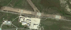
A really good point. I think this right there is the key to the ufos. See this map from 6 years ago and how much unmanned flight activity is now happening from the island closest to where these sightings were.Also, worth noting, there is a drone base on San Clemente Island that was built from a derelict airstrip sometime between 2014-2018
https://satellites.pro/USA_map#32.946860,-118.532774,19
View attachment 44499
Thank you for the information!138 knots is actually pretty fast for a drone, and usually can only be accomplished by the higher performance, larger air frame versions. The ones that rival actual aircraft in size. For example, the MQ-1 Predator tops out at 117 knots. The RQ-21 Blackjack, which seems to be the primary US Navy drone, tops out at 90 knots. 138 knots for a drone in a drone swarm would probably warrant a "holy shit", especially when it seems the rest were cruising at 50 knots.
Weren't there also very strong 40 knots winds during the event. A light drone moving at around 100 knots, at the right angle, could accelerate up to 138 knots. Do we have the wind direction available anywhere ?Apparently, drone racing is a thing. As of April 2019, the world speed record for a non-military drone was over 160 mph, and in short bursts speeds of up to 180 mph were possible. Still, 138 knots is indeed pretty fast, if it was not a radar glitch or a misreading of the data on screen.
Thank you for the information!
However, in the List of Fastest Military Drones in The World, the Rustam H, with a top speed of 225 kmph has a wingspan of 7m.
Rustom - H
The Camcopter S-100, with a max speed of 120 kn(220 km/h) has a wingspan of 3.11 m. Also, 18 of these were purchased by China in 2010.
Camcopter S-100
As you said, there are also drones with wingspan of 16.6m, 20m and 40m.
No, I don't think we have confirmation for dates or collaboration with other events. However, if the wind speed was 40 kn, then a contact flying at a speed of around 100,105 kn may have been accelerated up to 138 kn if the wind was at the right angle. Also, do we know if the speeds the officer throws out are relative to the ground or the ship ?Got to remember as per the Omaha Sphere video, winds were gusting that day to 40knt. So not sure if the radar data is from the same day. Was that confirmed?
")
") You may want to follow this guide to turn off un-needed features and speed up Google Earth to make it a bit easier to work with the data. Still, at least it excludes that. One thing that is interesting is the vessel 'Variable'. It and the Sea Ace appear to be the only two vessels that pass through the Omaha's radar circle (albeit a few hours after we think that clips 1, 2 and 3 of the video were recorded). For some reason though its AIS has only three records for the entire time period even though it obviously traverses the entire area of interest. I looked at the complete record for the three days and its AIS reports very intermittently and almost randomly. It might be interesting to see if its position relative to the Omaha matches up with any of the surface contacts shown on the screens, although of course it's not really a vessel that can do 138 knots Either that or it's an AIS transmitter attached to A DRONE. (LOL, kidding. Is he kidding?) I'll double check the data but it looks legit to me so far.
You may want to follow this guide to turn off un-needed features and speed up Google Earth to make it a bit easier to work with the data. Still, at least it excludes that. One thing that is interesting is the vessel 'Variable'. It and the Sea Ace appear to be the only two vessels that pass through the Omaha's radar circle (albeit a few hours after we think that clips 1, 2 and 3 of the video were recorded). For some reason though its AIS has only three records for the entire time period even though it obviously traverses the entire area of interest. I looked at the complete record for the three days and its AIS reports very intermittently and almost randomly. It might be interesting to see if its position relative to the Omaha matches up with any of the surface contacts shown on the screens, although of course it's not really a vessel that can do 138 knots Either that or it's an AIS transmitter attached to A DRONE. (LOL, kidding. Is he kidding?) I'll double check the data but it looks legit to me so far.I'm done for the day but I should be able to get this and produce KMLs in the next 24 hours.The Drive article says that the drone activity started again from 25th to 30th July. What were the ships within a 100nm radius of San Clemente Island during that time ?
Right. And the USS KIDD, which also reported encounters, was 90 nautical miles away when things got exciting. My guess is also that this was a drone exercise. Send a bunch of drones out to harass a bunch of ships in the middle of an exercise, maybe without telling them ahead of time-- what better way to get a real-world assessment of the readiness of the fleet to deal with such threats?Got to remember that the fleet encountered drones from at least the 14th to at least the 30th. ie over two weeks
As far as I can gather, all sorts of training exercises!The Drive article says that the drone activity started again from 25th to 30th July. What were the ships within a 100nm radius of San Clemente Island during that time ?
As best as I can gather, the ships in the area were running various training exercises. I do need to make an amendment to my previous posts, which is that I am no longer convinced the crew training aboard the USS Omaha was the gold crew for the USS Montgomery. Judging by the timeline it was possibly a different LCS crew in training.External Quote:
...
The Independence-varient [SIC] littoral combat ship USS Gabrielle Giffords (LCS 10) maneuvers to deter an unmanned vessel during a small boat attack exercise.
I am not sure about the drone theory. Let me explain.Right. And the USS KIDD, which also reported encounters, was 90 nautical miles away when things got exciting. My guess is also that this was a done exercise. Send a bunch of drones out to harass a bunch of ships in the middle of an exercise, maybe without telling them ahead of time-- what better way to get a real-world assessment of the readiness of the fleet to deal with such threats?
From my previous posts, evidence that SWATT (the specific training being mentioned in this briefing) was being conducted on the USS Omaha around the time of the July events has been shown. I also showed evidence that such training was filmed for debrief purposes.External Quote:
...Experiments during SWATT...
2018/2019 – UxS and C-UxS
Unmanned Mine Neutralization Experiment will leverage the combination of USVs and ROVs to alleviate requirements to place human operators in danger areas • End-to-end UxS MCM operations
UAS and UXS . Experimentation to evaluate new UxS systems which help close gaps and validate new variants of MQ-8C Firescout and MQ-4C Triton.
Black Dart Maritime 2018 . Experiment will examine near-term C-UAS capabilities in response to urgent operational needs and current events in the maritime environment: • Validation of C-UAS TTP
The evidence of 138kn speed comes from the speaker - the readout we see doesn't seem to agree. I highlighted that here:Thanks for the great analysis !
While I saw that there are several speed boats capable of approaching speeds of =<250 kmph, would they be able to maneuver in stormy conditions ?
I'm deeply curious as to where the speaker gets the 138 knots measurement from. The UI as posted by Mick and as seen in the video has two places where SOG (Speed over ground) is displayed in knots.
View attachment 44496
View attachment 44497
During all other clips where speed is given by the speaker, the SOG is displayed on the right hand panel and seems (to my naked eye, having slowed down and attempted to sharpen the footage the best I can make out are how many digits there are) to align with what is said. However, during the "138 knots" clip, the SOG is not being displayed on the right hand panel. The upper left panel where it would be displayed appears to show a two digit number (with one decimal place).
View attachment 44498
So it doesn't seem like the speaker can be getting the 138 knots figure from any of the displayed instrumentation. Would they have been able to get that figure from elsewhere, perhaps a different display tracking something else? Is it possibly a mistake in relaying the COG (course over ground), which is measured in degrees and does appear to be a three digit number?
Excluding the 138 knot outlier, the other mentioned speeds are 46, 50, and 55 knots.
One possibility is that the radar was displaying the ground speed while the speaker says the relative speed, since that particular contact seems to be moving head on towards the ship. We have so little context for the clips, it's hard to say anythingThe evidence of 138kn speed comes from the speaker - the readout we see doesn't seem to agree. I highlighted that here:
Like they did with the Tic Tac happenings including the Radar stuff, and also how they did with the Gimbal stuff?The Navy base on San Clemente Island would be an obvious source for drones (fixed wing or copter) but it would be surprising if that was the whole story. Even if the drone operations were secret at the time, would the Navy really let media speculation about 'drone incursions' run riot if they knew all along that the mystery objects were their own drones? Surely they would issue some general statement about 'training exercises' to reassure the public.
FY 2018 to FY 2019 Increase/Decrease Statement:The FY18 to FY19 decrease is due primarily to the completion of Nemesis, a distributed EW systems project.
Doesn't make sense. Unless we think a private company is testing advanced tech without the US govmt involvement.Just for geographic reference
This is where the Skunkworks and Plant 42 are . ie where they develop advanced aerospace/aircraft technology / black projects. All the usual suspects are there .
I wonder where they would test new aircraft tech, drones etc, geez I wonder . Hmmmmm
Or, at least, they thought they were encountering drones to at least the 30th. Once a flap starts, whether a "traditional" UFO flap or a more modrn drone flap (or even an evil clown lurking in the woods flap!) folks tend to see UFOS, drone (or clowns) until the hyseria dies down -- whether they are there or not.Got to remember that the fleet encountered drones from at least the 14th to at least the 30th. ie over two weeks
Corbell's website says, "This footage is unclassified."
External Quote:https://www.extraordinarybeliefs.com/news4/navy-ufo-radar-data
APPROXIMATE LOCATION OF SHIP / USS OMAHA
32°29'21.9"N 119°21'53.0"W (Warning area off of San Diego)
APPROXIMATE DATE & TIME OF EVENT SERIES
Monday July 15th, between the hours of 9pm - 11pm PST
DETAILS
- Minimum 14 targets (estimate).
- Minimum 6ft in diameter - solid mass (estimate).
- Varying speeds from 40 kts - 138 kts (46 mph - 158 mph +).
- Flight lasting longer than an hour.
- Unknowns were self-illuminated.
- Neither origin, nor launch or landing points were able to be determined.
- Unknown vehicles picked up on more than two types of RADAR.
- Still images of this footage were included in the May 1st, 2020 UAPTF intelligence briefing that I have previously reported on.
- It is noted in intelligence reports that the "spherical" craft appeared to be transmedium capable, and were observed descending into the water without destruction.
- It is noted in intelligence reports that the "spherical" craft could not be found upon entry to the water - that a submarine was used in the search - and recovered nothing.
- This footage is unclassified.
- Craft remain unidentified - officially.
"The most impressive evidence we witnessed was their endurance. The event lasted over an hour with all contacts just disappearing. We were never able to discern where they departed to." - Crewman, USS Omaha
I'm clearly no expert in this area but I think the green square on the display saying 'Unclassified' more likely is saying that the currently selected contact is unclassified. I.e.: the system has not automatically identified it (using AIS for starters I suppose) and the operator has not specified its classification.Corbell's website says, "This footage is unclassified."
I'm clearly no expert in this area but I think the green square on the display saying 'Unclassified' more likely is saying that the currently selected contact is unclassified. I.e.: the system has not automatically identified it (using AIS for starters I suppose) and the operator has not specified its classification.
Doesn't seem intuitively right that the secure operations area on a warship would have a button or telltale to let everyone know that the data on the screen is unclassified
As to the 'Unclassified' marking, I like Heavytread's interpretation. It's difficult to see how a security classification could be applied in advance of knowing what is on the screen! It might turn out to be something highly sensitive. In any case, I doubt that even an 'Unclassified' security marking would give service personnel carte blanche to leak it.
Even unclassified material still requires authorization for release, so it doesn't need to be classified to be an unauthorized release.Security classification could depend on the maximum range, for example.
Pentagon spokeswoman Susan Gough made it clear that the leak wasn't authorized: "I can't comment on what we may doing about these unauthorized releases at this time."
I need to get on with other stuff for the day but one last thought: if the Omaha is seeing this stuff on commercial rather than military radar, and the Sea Ace is a big expensive car hauler with no doubt some very expensive radar to make sure that the ocean floor isn't littered with Toyotas, shouldn't they have at least seen the thing zipping around on radar just about two nautical miles away? Given that a ship that size turns with the approximate handling and braking characteristics of a planet-sized block of lead, wouldn't their radar need to reach out way past a few nautical miles? And so wouldn't they have seen this entire thing unfolding?
I wonder if it's possible to track down who would have been on the bridge at that time and interview them. Another possible line of inquiry I guess.
I'm clearly no expert in this area but I think the green square on the display saying 'Unclassified' more likely is saying that the currently selected contact is unclassified. I.e.: the system has not automatically identified it (using AIS for starters I suppose) and the operator has not specified its classification.
Doesn't seem intuitively right that the secure operations area on a warship would have a button or telltale to let everyone know that the data on the screen is unclassified
Re the 138 knot thing, as re my previous post there's a cut here:
:24 "Track 781 just sped up to 46 knots. 50 knots. Closing in."
CUT 2?, tracks move slightly and VV changes direction and camera jumps again.
:33 "138 knots. Holy s***. They're going fast. Oh, it's turning around."
I assume here the easy assumption (that we would expect people to take from a cursory glance at the video) is that track 781 goes 46 knots, 50 knots, then 138 knots a good acceleration.
But when he says directly after with no cut
:36 "That one's pretty much perfectly zero zero zero relative, right?"
:39 "Yeah."
You can see track 781 is the boxed track near the cursor there's no speed given on the RADAR screen.
There is a different track almost exactly on the line inside the cone which I think is the directly forward of the ship (0,0,0) with a long velocity vector line.
The target ID would be on the right, under Selected Target, like where the image below says CLARA MAERSK. This image doesn't have the UNCLASSIFIED marking. UNCLASSIFIED in green looks like a security classification, and a different term would be used for unrecognized targets.
This is all correct. There is a cut at 31s, which begins the part of the video where they are talking about something going 138 kn. It's clearly taken at a different time from the previous cut. Target 781 is still selected but the data pane on the right hand side of the screen has been set to a different tab so its data isn't visible. I think this is all covered by my analysis a few posts up where we infer the speed of the targets by measuring them against target 781's known speed. The track you're referring to is the one I think they are talking about, but it apparent speed it 68 knots.
Speaker 1 says: "138 knots. Holy s***. They're going fast. Oh, it's turning around."
Speaker 2 says (apparently in direct reply to speaker 1): "That one's pretty much perfectly zero zero zero relative, right?"
Speaker 1 says (apparently in direct reply to speaker 2's question: "Yeah"