USS Omaha UFO / UAP Radar Video

40 frames / (30 frames / 1 second) => (40 frames * 1 second) / 30 frames => (40 frames / 30 frames) * 1 second => (40 / 30) second

Wow, I totally misread the original. So much so that I didn't even recognise it on rereading. Need more coffee.
 
They are vector showing direction lines, they can be True or Relative depending on the mode of the RADAR.

The length seeming indicates predicted distance that will be travelled in whatever time the RADAR is configured for

You can also have "trails" indicating previous position if you want

This is a manual for a similar RADAR system I mean it's possible it means something completely different in this RADAR but it's not likley.

https://www.marinsat.com/marinsat/dosyalar/dosya/CD65800010A-6_Rev_A_-_User_Manual.pdf

Chapter 5
Agree this is also what I would expect.

I think you can also see the USS Omaha Vector starting from the center (which also seems to be curved in certain moments (maybe the ship was maneuvering?).

However: the movements of the contacts do not match the direction lines. Why is that? They seem to be erratically jumping around instead of following the predicted direction lines.

Also those direction lines seem extremely long compared to the USS Omaha's vector. Is that consistent with a reported top speed for the Omaha of 40+ knots? https://en.wikipedia.org/wiki/USS_Omaha_(LCS-12)

I think we should try to gather as much data from the screen as we can by analysing all the symbology and movements as much as we can.
 
At regular intervals throughout the the video this panel changes:

from

1622284682596.png
To
1622284606767.png

and then back again

In the reference screenshot it shows date/time

What does it say "Running in <something> mode?"

Why would the time indicator be flashing between a mode and the time?

Also in this frame you can just about read the time 16 Jul 2019 04 42 XX UTC? Seems consistent with the time match from the Swan Ace logs, at least there's no contradictory number I can see.

1622285055076.png
 
Last edited:
@JFDee

Isn't the Swan Ace a vehicle carrier registered to the Bahamas?
Or do I have another ship mixed up with it?

I think most of the large ships worldwide are registered to Panama, Liberia or the Bahamas. That doesn't say much about the company using them or the area in which they travel. It's mainly for evading taxes and regulations.
 
I noticed that sometimes the blips on the radar screen do not follow their predicted velocity vector but instead move perpendicularly

Doppler Radar
Is there any possibility that the radar used is a Doppler radar ? This type of radar uses the Doppler effect to analyse the velocity data of an object. It does this by bouncing a microwave signal off the desired target and analyzing how the object's motion has altered the frequency of the returned signal. It automatically eliminates return signals from weather, terrain, and countermeasures like chaff. It is also very effective against low-flying aircraft to eliminate the ground clutter, which always has zero speed/shift. It makes good sense to have it on a warship.

A countermeasure to this, used by low-flying planes (maybe drones) is to turn perpendicular to the hostile radar to nullify the Doppler frequency. This usually breaks the lock and drives the radar off by hiding against the ground noise. I think we observe both perpendicular travel and sudden disappearance in the video. [ Corbell attempts to explain it by saying that the 'UFOS' are flying off very high or into the water. I think Doppler countermeasures offer another, more realistic hypothesis].
 
I think most of the large ships worldwide are registered to Panama, Liberia or the Bahamas. That doesn't say much about the company using them or the area in which they travel. It's mainly for evading taxes and regulations.
I think the name of the owner or company of the Ship can be purchased. I'm not sure about the price though
 
Can be found for free on Wikipedia! The ship is/seems to be operated by Mitsui O.S.K Lines.

Makes sense. China car exports likely don't match those from Japan yet. I bet the port preceding Canada was in Japan.

It's still interesting why it slowed down all of a sudden on the evening of July 15.
 
I'm not very well versed on US Navy procedure. This part of the transcript confuses me:

:01 “OOD if you can write a general LAT/LONG of where we’re at.”
...
:05 “Yes Sir.”
:06 “And then… the number of contacts you’ve got. Get the course and speed meters off 'em.”
:09 “Copy.”
:10 “You know what I mean? In relative position to us. And bearings. Might be helpful too.”

This exchange is between the OOD (Officer of the Deck) and someone else, who is directing them. Who would have the ability to task the OOD like this?
 
A HYPOTHESIS ON THE USS OMAHA RADAR DATA
I feel that at present, the available evidence points to the following hypothesis-
While traveling at a routine speed, the USS Omaha stumbled into the activity of a certain number of unidentified low-flying drones(very,very low chance of being manned aitcraft)close to San Clemente Island, which were recorded on the ships Doppler radar. These drones are likely to have two possible sources.
A) Testing from San Clemente Island
B) Released from a nearby ship, submarine or (possibly unmanned)plane.*
1622233866225.png
At some point of time, probably around 9 pm local time, the USS Omaha turned off its AIS transistor to conceal its location, and went to the co-ordinates we see in the video in order to investigate. At this time, the drones exhibitited common countermeasures against Doppler Radar by flying perpendicular. This also has the desired effectof making the radar lose lock.The drones allegedly reached speeds of upto 250 kmph (which is quite normal for military drones) possibly helped by strong winds.

In the early hours of the morning, probably after the drones had departed, the Omaha turned on its AIS transistor again, indicating that she felt that the threat had passed. For the next few hours, it maneuvered around the area, possibly searching for debris.
‐----------------–------------------------------------
*
It is possible that the plane in the Bokeh video, which was reportedly unidentified and flew at a relatively low height of 737m, dropped off the drones.


Ok pals, this is my current hypothesis. I would greatly appreciate if anyone has any data that challenges the above hypothesis
 
Where are you getting that the plane was at 737 metres up a plane that low would be very very noticeable. The triangle object is more likely a normal civilian airliner at 30k+ feet.
 
At this time, the drones exhibitited common countermeasures against Doppler Radar by flying perpendicular. This also has the desired effectof making the radar lose lock.The drones allegedly reached speeds of upto 250 kmph (which is quite normal for military drones) possibly helped by strong winds.
Not sure what you mean by this.

The contacts are in plain sight and going in all directions relative to the ship. They aren't "hiding" or flying perpendicular.

Of note:
- at around 10 seconds two contacts disappear close to the SWAN ACE. Could they be landing for recovery?
- according to the tracks reported in the thread the SWAN ACE slowed down at some point before the incident. Was it launching the drones?

Of course this could be just a coincidence. And what happened to the other contacts? They were just abandoned into the sea and sank?

In the last part of the video the SWAN ACE is no longer in view. How far was the OMAHA at that point from the SWAN ACE?

Do we know if the video we have is from the same event? Do the dates match? The IR image doesn't look like a normal drone would.

I think we need to stick to the data we have (further analysis of the video) before trying to speculate on what is going on here. There is still more data we can uncover.
 
Where are you getting that the plane was at 737 metres up a plane that low would be very very noticeable. The triangle object is more likely a normal civilian airliner at 30k+ feet.
Most likely the plane was at 30k+ feet. But some sources claimed that eyewitnesses said the plane was flying low. I don't trust unverified eyewitness data, but I thought I'd throw it in for posterity.
 
Ok pals, this is my current hypothesis. I would greatly appreciate if anyone has any data that challenges the above hypothesis
I'll see what I can do!

1:
While traveling at a routine speed, the USS Omaha stumbled into the activity of a certain number of unidentified low-flying drones(very,very low chance of being manned aitcraft)close to San Clemente Island, which were recorded on the ships Doppler radar.
I was able to find some information that naval radar incorporates Doppler radar.
From https://www.militaryaerospace.com/sensors/article/14174156/shipboard-radar-missiledefense
The AN/SPQ-9B is an X-Band pulse-Doppler frequency-agile radar that scans out to the horizon and performs simultaneous and automatic air and surface target detection and tracking of low flying anti-ship cruise missiles, surface threats, low-and-slow-flying aircraft, unmanned aerial vehicles (UAVs), and helicopters.
Content from External Source
However, I have not found evidence that drones exhibit the capability to maneuver in the way you suggest happens in the video, or evidence that they avoid Doppler radar in the way you describe.
A countermeasure to this, used by low-flying planes (maybe drones) is to turn perpendicular to the hostile radar to nullify the Doppler frequency.
Here is where in the Wikipedia article that statement is drawn from.
From: https://en.wikipedia.org/wiki/Doppler_radar
Low-flying military plane with countermeasure alert for hostile radar track acquisition can turn perpendicular to the hostile radar to nullify its Doppler frequency, which usually breaks the lock and drives the radar off by hiding against the ground return which is much larger.
Content from External Source
Wikipedia mentions such a plane is using an "alert for hostile radar track acquisition". Is there evidence that military drones have the same or a similar capability? Sources with links will bolster your hypothesis.

2:
These drones are likely to have two possible sources.
A) Testing from San Clemente Island
B) Released from a nearby ship, submarine or (possibly unmanned)plane.*
...
*
It is possible that the plane in the Bokeh video, which was reportedly unidentified and flew at a relatively low height of 737m, dropped off the drones.
Is there evidence for drone testing off San Clemente island? The Drive article on the July Drone sightings pointed out the investigation into them went quite high up the chain of command, to people who potentially would have knowledge on San Clemente drone testing.
From https://www.thedrive.com/the-war-zo...us-drones-off-california-over-numerous-nights

To be sure, San Clemente Island and nearby training area FLETA HOT are hosts to a bevy of testing, which can include classified programs. Is it possible that the drones were operated by the military itself in an errant test of some kind?

If so, the incursions continued after a concerted investigation that reached the highest level of the Navy hierarchy. It also appears that no UAV activity was scheduled by FASFAC San Diego during July 14th. On the other hand, it is a general area where extremely strange things have occurred in the past.
Content from External Source

3:
In the early hours of the morning, probably after the drones had departed, the Omaha turned on its AIS transistor again, indicating that she felt that the threat had passed. For the next few hours, it maneuvered around the area, possibly searching for debris.
The maneuvering of the Omaha happens before the video was taken, not after.
Interestingly, the sharp turn to starboard that begins the period of maneuvering happens at about 5:00 AM local time on July 14:

1622233785739.png
The maneuvering is before the gap in AIS data begins.

I hope that is helpful to your hypothesis!
 
Not sure what you mean by this.

The contacts are in plain sight and going in all directions relative to the ship. They aren't "hiding" or flying perpendicular.

Of note:
- at around 10 seconds two contacts disappear close to the SWAN ACE. Could they be landing for recovery?
- according to the tracks reported in the thread the SWAN ACE slowed down at some point before the incident. Was it launching the drones?

Of course this could be just a coincidence. And what happened to the other contacts? They were just abandoned into the sea and sank?

In the last part of the video the SWAN ACE is no longer in view. How far was the OMAHA at that point from the SWAN ACE?

Do we know if the video we have is from the same event? Do the dates match? The IR image doesn't look like a normal drone would.

I think we need to stick to the data we have (further analysis of the video) before trying to speculate on what is going on here. There is still more data we can uncover.
Yeah...there's still a lot of analysis left to be done. At certain points, the contacts seem to jerk 90° to the predicted velocity vector, which is usually intended to throw off the Doppler radar lock. This also effectively hides the contact against the ground noise, as it becomes 0 shift. That maybe the reason they disappeared at 10 second mark.
1) I also had a suspicion that the Swan Ace is involved somehow , maybe as a takeoff/landing base, but I did not want to make any claims without evidence. I think a lot of analysis has to be done before we can say anything on its role.

2) I think the Swan Ace slowed down but did not stop, right ? At that time, USS Omaha was possibly moving in the opposite direction, with the AIS transistor off. So Swan Ace could have moved out of range.

3) I have no info on how the contacts ended. All we know is that at some point, USS Omaha felt it safe to turn on her AIS transistor again

4) I don't think much analysis has been done yet as to whether the radar data corroborated with previous videos. Also, please correct me if I'm wrong, but the IR video was hypothesized to be a IR glare, right ?
Thank you so much for the interaction !
 
T
I'll see what I can do!

1:

I was able to find some information that naval radar incorporates Doppler radar.
From https://www.militaryaerospace.com/sensors/article/14174156/shipboard-radar-missiledefense
The AN/SPQ-9B is an X-Band pulse-Doppler frequency-agile radar that scans out to the horizon and performs simultaneous and automatic air and surface target detection and tracking of low flying anti-ship cruise missiles, surface threats, low-and-slow-flying aircraft, unmanned aerial vehicles (UAVs), and helicopters.
Content from External Source
However, I have not found evidence that drones exhibit the capability to maneuver in the way you suggest happens in the video, or evidence that they avoid Doppler radar in the way you describe.

Here is where in the Wikipedia article that statement is drawn from.
From: https://en.wikipedia.org/wiki/Doppler_radar
Low-flying military plane with countermeasure alert for hostile radar track acquisition can turn perpendicular to the hostile radar to nullify its Doppler frequency, which usually breaks the lock and drives the radar off by hiding against the ground return which is much larger.
Content from External Source
Wikipedia mentions such a plane is using an "alert for hostile radar track acquisition". Is there evidence that military drones have the same or a similar capability? Sources with links will bolster your hypothesis.

2:

Is there evidence for drone testing off San Clemente island? The Drive article on the July Drone sightings pointed out the investigation into them went quite high up the chain of command, to people who potentially would have knowledge on San Clemente drone testing.
From https://www.thedrive.com/the-war-zo...us-drones-off-california-over-numerous-nights

To be sure, San Clemente Island and nearby training area FLETA HOT are hosts to a bevy of testing, which can include classified programs. Is it possible that the drones were operated by the military itself in an errant test of some kind?

If so, the incursions continued after a concerted investigation that reached the highest level of the Navy hierarchy. It also appears that no UAV activity was scheduled by FASFAC San Diego during July 14th. On the other hand, it is a general area where extremely strange things have occurred in the past.
Content from External Source

3:

The maneuvering of the Omaha happens before the video was taken, not after.

The maneuvering is before the gap in AIS data begins.

I hope that is helpful to your hypothesis!
Thank you !
 
I will immediately look into whether military drones are capable of performing such maneuvers. I also think that the possibility of it being testing from San Clemente Island is low, as it surely would not have been allowed to leak if it were the case
 
3. Wasn't the video taken at around 9 pm local time ? I
Edit:- I got the dates mixed up, i think.
If I may ask, when did the Omaha turn on the AIS transmitter again ? Also, then the time scale would be (i) Omaha detects unidentified drone activity at 0500 am local time and (ii)investigates for some time. At some point, it deems it necessary to (iii)switch off its AIS transmitter and maneuvers to the point where we see the video. (iv)Later, it deems it safe to turn on AIS again
 
Last edited:
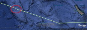
Coming back to the Swan Ace and the sudden slow-down. Here is the track from the respective timespan, in 2-minute resolution from the open AIS data. However, this data places the slow-down around 17h / 5pm.

I wrote a quick script that filters for a ship's name and creates a KML track or a series of points from the positions.

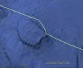
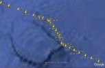
There was obviously a veritable evasion maneuvre going on at around 5 pm local time on July 15.
I wonder if there is a record somewhere about this incident.

Track overview:
swanace_slowtrack.jpg

Track detail:
swanace_slowtrack_detail.jpg

Track points with timestamps:
swanace_pointtrack.jpg
 

Attachments

  • swan_ace_pointtrack.kml
    39 KB · Views: 198
There was obviously a veritable evasion maneuvre going on at around 5 pm local time on July 15.
...
Track detail:
swanace_slowtrack_detail.jpg

Track points with timestamps:
swanace_pointtrack.jpg
Could it be a course correction to avoid (or "evade", I suppose) the large terrain feature on the map there? I noticed that the Omaha seems to make similar moves around undersea terrain in the screenshot posted here:
 
Unfortunately, I was not able to find any info on whether drones can exhibit such flight patterns as i have posited. Since my knowledge on drones is limited, would anyone who has a better knowledge of the subject please confirm whether it is possible for a drone to fly perpendicularly in order to unlock radar. To me it seems quite doable, even autonomously.
 
Could it be a course correction to avoid (or "evade", I suppose) the large terrain feature on the map there? I noticed that the Omaha seems to make similar moves around undersea terrain in the screenshot posted here:

A terrain feature would be well known and would be factored in the course to avoid it without slowing down.

I think there was a moving obstacle or some other incident.
 
A terrain feature would be well known and would be factored in the course to avoid it without slowing down.

I think there was a moving obstacle or some other incident.
It could be (a) a normal course correction
(b) possibly, the Swan Ace also detected the drone(s) on its radar and avoided it(them)
(c) it could have detected the USS Omaha via radar, which was possibly investigating the area with AIS turned off

Also, does anyone know a resource where i can check weather conditions and wind speed at a particular lat/lon on a given date ?
Thanks
 
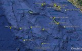
For completeness' sake, here are the ships in the area from the AIS data, at around July 16, 04:40h UTC, the time that @Heavytread determined:

ships_at_04h40.jpg
 

Attachments

  • ships_at_04h40.kml
    9.6 KB · Views: 190
I would add 4) Unknown natural phenomenon. I doubt we've discovered the full range of things such as sprites, earthquake lights, etc. The list should definitely include the possibility that whatever is being observed is not 'technology' at all.
I totally believe that atmospheric plasmas and charged dust clouds account for most "real" UFO sightings but in this event, I think the "drone swarm" theory is the more likely explanation.
 
4) I don't think much analysis has been done yet as to whether the radar data corroborated with previous videos. Also, please correct me if I'm wrong, but the IR video was hypothesized to be a IR glare, right ?
Glare is one hypothesis still on the table but there is no clear consensus on what the video shows. Quite a few things could explain what we see in the video but there just isn't enough data to make a solid case for any explanation IMO.

I agree with you that if this was an exercise of some sort it would never have leaked. Recording a radar screen inside the CIC/ICC during a live exercise and then leaking it to the media would be grounds for court martial and it would be trivial to figure out who was running the radar at the time and who recorded it. On one hand it's hard to believe Gough's assertion this leak is unauthorized because of the immense risk involved in recording such a video. On the other hand it's hard to believe the Navy would purposefully leak a video showing live radar operations as that would presumably break OPSEC.
 
For completeness' sake, here are the ships in the area from the AIS data, at around July 16, 04:40h UTC, the time that @Heavytread determined:

ships_at_04h40.jpg
Placing the USS Omaha to the south east of Swan Ace would make the nearest naval ship (with AIS data available at the time) the USS John Finn. There may be other naval ships unseen through an analysis of the AIS data.
 
Glare is one hypothesis still on the table but there is no clear consensus on what the video shows. Quite a few things could explain what we see in the video but there just isn't enough data to make a solid case for any explanation IMO.

I agree with you that if this was an exercise of some sort it would never have leaked. Recording a radar screen inside the CIC/ICC during a live exercise and then leaking it to the media would be grounds for court martial and it would be trivial to figure out who was running the radar at the time and who recorded it. On one hand it's hard to believe Gough's assertion this leak is unauthorized because of the immense risk involved in recording such a video. On the other hand it's hard to believe the Navy would purposefully leak a video showing live radar operations as that would presumably break OPSEC.
It's all very confusing....I find it hard to believe that the US Navy allowed someone to even take cellphone footage of a 2019 radar unit
 
Is there any information on the ship TORM Vita ?
From what I found out, it is an oil/chemical tanker, is owned by the Dutch company Torm, and its country of origin is Singapore. Where can we find out its destination and port of origin in July 2019 ?
 
I find it hard to believe that the US Navy allowed someone to even take cellphone footage of a 2019 radar unit
I begin to find it hard to believe that there would be a sudden rash of unauthorized leaks on UAP/UFO incidents, all from the Navy and most from the same training/testing range. "Once is happenstance, twice is concidence, three times is enemy action," as the saying goes. We now have six leaked videos, all from the Navy, all but two from the range(s) off San Diego. Plus various eyewitness or purported eyewitness accounts not coming through official military channels.

I have nothing that is non-speculative to add to WHY that might be, and I don't know if there is anything there subject to analysis to warrant its own thread. (If anybody thinks there is anything there worth analyzing beyond guesses ad speculation, maybe start a thread?) But as each of these individual incidents is analyzed, it is probably worth keeping in mind that multiple leaks over a period of time on the same topic coming from only one service branch may may have some significance, and the liklihood of that would go up with each subsequent leak.

Edited to mention the "Batman Balloon" photos, which I forgot to mention. Also from Navy plane(s).
 
Last edited:
Has it been established whether the radar (in this configuration) is only detecting low-level objects (surface or near-surface), and if so what is the upper height it would register? It was suggested at #50 that the object seen at about 310 degrees might be showing as 'friendly air', but in Mick's cleaned-up version at #28 the symbol seems to mark just another 'surface' object.
I think the question is important, because during the brief video some objects suddenly appear or disappear, or at least move through long distances in between frames. This leads Corbell to claim that they are doing extraordinary things. I wondered if the different 'clips' in the video had been taken at widely different times, which would allow time for objects to move horizontally in and out of shot, but #93 [edited: previously said #97 in error] seems to show that they all fall within a period of only a few minutes. [Added: #93 doesn't estimate the time of the final clip since the Swan Ace ship which formed a key reference point had disappeared from the screen. This is important, as it is the final clip which suddenly shows a large number of 'UAPs'. Moreover, the disappearance of the Swan Ace, after moving very little during the previous clips, suggests that there was a larger time interval before the final clip. It is also a counterexample to any assumption that in the video 'sudden disappearance' equates to 'shoots off into space', since nobody will suppose that this happened to the Swan Ace!) The sudden changes are difficult to explain, unless the objects are simply moving into or out of the vertical range of the radar. Drones can rise or drop through (say) 50 feet pretty quickly, so if the radar is confined to the near-surface level the movements would be less of a problem.
 
Last edited:
I begin to find it hard to believe that there would be a sudden rash of unauthorized leaks on UAP/UFO incidents, all from the Navy and most from the same training/testing range.

Same. Hopefully we're not getting too off-topic here, feel free to delete if so, but I think this conversation is worth having in the broader context of these "leaks" and the legalities involved in both the recording of the videos and the dissemination of them to the media.

Recording/Phone Use
I think most here would agree both videos were recorded with a cell phone. This forum thread mentions that there are no specific regulations preventing sailors from having personal cell phones but they generally can't get cell signal, can't connect to ship networks, and need to be off or in airplane mode when EMCON is declared.
There's no cell connection they can generally get underway. Just having GPS doesn't do anything -- people know where the ship is anyway.
They can't connect them to shipboard networks at all.
And generally they have to be in airplane mode -- emcon is definitely a thing.

Here is an example of a sailor who was tried and sent to prison for taking unauthorized photos inside a submarine. From what I've read, personal device use on submarines is a little more strict.
Kristian Mark Saucier (born c. 1986) is a former U.S. Navy sailor who was convicted of unauthorized retention of national defense information and sentenced to one year in prison in October 2016 for taking photographs of classified engineering areas of USS Alexandria (SSN-757), a nuclear-powered attack submarine, in 2009.

Guidelines on having a cell phone on your person:
Can I wear my personal cell phone on my belt while in uniform?
The answer to this question is yes. In accordance with U.S. Navy Uniform Regulations, Chapter 2, Section 1, Article 2101.3c:

I could find no evidence that it is permissible to record screens onboard a ship without reprimand and an abundance of evidence that doing so can have severe consequences. It seems reasonable to me that these videos were recorded with permission from superiors and they weren't covertly recorded. I don't think the people who recorded the screens will face any consequences but the question then becomes how did these videos make it to the media. Is the list of people with access to UAPTF related materials broad enough that it would be unclear who is leaking media to Corbell?

A final note, Corbell has said he has multiple leaks and is releasing them over time instead of all at once. It is possible someone leaked all of this media to him as one dump and there is no ongoing contact with the leaker.
 
Has it been established whether the radar (in this configuration) is only detecting low-level objects (surface or near-surface), and if so what is the upper height it would register? It was suggested at #50 that the object seen at about 310 degrees might be showing as 'friendly air', but in Mick's cleaned-up version at #28 the symbol seems to mark just another 'surface' object.
I think the question is important, because during the brief video some objects suddenly appear or disappear, or at least move through long distances in between frames. This leads Corbell to claim that they are doing extraordinary things. I wondered if the different 'clips' in the video had been taken at widely different times, which would allow time for objects to move horizontally in and out of shot, but #97 seems to show that they all fall within a period of only a few minutes. The sudden changes are difficult to explain, unless the objects are simply moving into or out of the vertical range of the radar. Drones can rise or drop through (say) 50 feet pretty quickly, so if the radar is confined to the near-surface level the movements would be less of a problem.
I think Mick surmised that the UI showed a surface level radar. This also explains the "138 knots, holy sh**t it's moving fast " remark since while 138 knots is normal for a military drone, it's incredibly fast for a boat. So the drones must be very near the surface, possibly even skimming the waves at times. Also, the sudden changes could be due to the contacts flying perpendicular, which is an evasive maneuver used by low-level aircraft to shake a radar-lock. Usually, this results in the contact being lost amidst ground noise. I think there are times in the video where the contacts both move perpendicular to the predicted velocity vector, and also shake off the radar lock. As you said, they could also be moving up.
 
138 knots is actually pretty fast for a drone, and usually can only be accomplished by the higher performance, larger air frame versions. The ones that rival actual aircraft in size. For example, the MQ-1 Predator tops out at 117 knots. The RQ-21 Blackjack, which seems to be the primary US Navy drone, tops out at 90 knots. 138 knots for a drone in a drone swarm would probably warrant a "holy shit", especially when it seems the rest were cruising at 50 knots.
 
I have edited my #153 above to correct an error and an oversight. The error was an incorrect reference to a previous post (#93). The oversight was that I had forgotten that #93 doesn't estimate the time of the final clip in the video, since the Swan Ace ship, which formed a key reference point, had disappeared from the screen. This is important, as it is the final clip which suddenly shows a large number of 'UAPs'. Moreover, the disappearance of the Swan Ace, after moving very little during the previous clips, suggests that there was a larger time interval before the final clip. It is also a counterexample to any assumption that in the video 'sudden disappearance' equates to 'shoots off into space', since nobody will suppose that this happened to the Swan Ace!
 
138 knots is actually pretty fast for a drone, and usually can only be accomplished by the higher performance, larger air frame versions. The ones that rival actual aircraft in size. For example, the MQ-1 Predator tops out at 117 knots. The RQ-21 Blackjack, which seems to be the primary US Navy drone, tops out at 90 knots. 138 knots for a drone in a drone swarm would probably warrant a "holy shit", especially when it seems the rest were cruising at 50 knots.
Apparently, drone racing is a thing. As of April 2019, the world speed record for a non-military drone was over 160 mph, and in short bursts speeds of up to 180 mph were possible. Still, 138 knots is indeed pretty fast, if it was not a radar glitch or a misreading of the data on screen.
 
Back
Top