You are using an out of date browser. It may not display this or other websites correctly.
You should upgrade or use an alternative browser.
You should upgrade or use an alternative browser.
Serpentine flight pattern over Los Angeles
- Thread starter Agent K
- Start date
Trailspotter
Senior Member.
Most likely, some kind of aero photogrammetry. LA Google 3D map or similar needs updating.What's going on here? A couple of Beechcraft King Airs out of Los Alamitos Army Airfield scanning L.A.
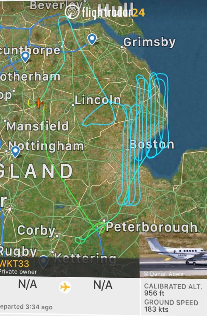
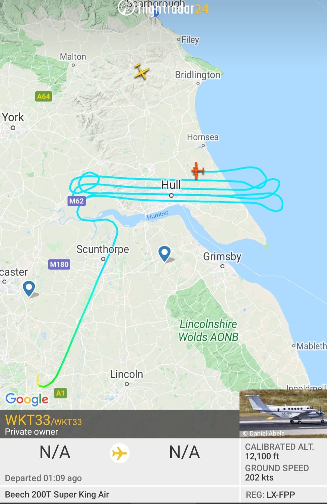
I regularly spot similar flights over my area of the UK. They are more noticeable now, because there are much fewer planes in the sky.
Edit
Added a couple of similar flight tracks in the UK, posted a week ago in one of the planespotting group on facebook, of which I am a member:


Last edited:
This guy was filming them from the ground a few years ago:
Source: https://www.youtube.com/watch?v=bgnACVY7hpA
He thinks they are spying on him. But he also links to a rather speculative story about the FBI doing cell-phone tracking sweeps.
https://privacysos.org/blog/fbi-sur...phones-across-major-cities-nationwide-report/
Source: https://www.youtube.com/watch?v=bgnACVY7hpA
He thinks they are spying on him. But he also links to a rather speculative story about the FBI doing cell-phone tracking sweeps.
https://privacysos.org/blog/fbi-sur...phones-across-major-cities-nationwide-report/
But I think that some kind of innocuous area scanning, like 3D maps, is the most likely explanation.External Quote:While an FBI spokesman told AP the bureau doesn't use its fleet of surveillance planes to conduct dragnet or bulk spying, the use of a stingray in a plane almost certainly results in just that. The planes "are not equipped, designed or used for bulk collection activities or mass surveillance," the spokesman said. That's very difficult to believe, because of how cell site simulators, also known as IMSI catchers, work.
Agent K
Senior Member
He thinks they are spying on him. But he also links to a rather speculative story about the FBI doing cell-phone tracking sweeps.
https://privacysos.org/blog/fbi-sur...phones-across-major-cities-nationwide-report/
But I think that some kind of innocuous area scanning, like 3D maps, is the most likely explanation.External Quote:While an FBI spokesman told AP the bureau doesn't use its fleet of surveillance planes to conduct dragnet or bulk spying, the use of a stingray in a plane almost certainly results in just that. The planes "are not equipped, designed or used for bulk collection activities or mass surveillance," the spokesman said. That's very difficult to believe, because of how cell site simulators, also known as IMSI catchers, work.
Surveillance would be more like what the police helicopters do, circling around trouble spots like this
I was thinking that the turboprops are either doing training or scanning the area. Wonder what they're scanning with.
Agent K
Senior Member
He thinks they are spying on him. But he also links to a rather speculative story about the FBI doing cell-phone tracking sweeps.
https://privacysos.org/blog/fbi-sur...phones-across-major-cities-nationwide-report/
External Quote:While an FBI spokesman told AP the bureau doesn't use its fleet of surveillance planes to conduct dragnet or bulk spying, the use of a stingray in a plane almost certainly results in just that. The planes "are not equipped, designed or used for bulk collection activities or mass surveillance," the spokesman said. That's very difficult to believe, because of how cell site simulators, also known as IMSI catchers, work.
The Joint Forces Training Base does host the 306th Psychological Operations Company
derwoodii
Senior Member.
i suspect its Lidar data collection for power company or infrastructure authority
https://www.metabunk.org/threads/n2...h-near-sacramento-lidar-data-collection.4307/
https://www.metabunk.org/threads/n2...h-near-sacramento-lidar-data-collection.4307/
Agent K
Senior Member
N66W scans almost every day.
https://flightaware.com/live/flight/N66W#flightPageActivityLog
https://flightaware.com/live/flight/N66W#

Owned by Dynamic Aviation, which does everything from ISR to spraying mosquitoes.
https://www.dynamicaviation.com/flight-solutions-and-services/
https://flightaware.com/live/flight/N66W#flightPageActivityLog
https://flightaware.com/live/flight/N66W#
Owned by Dynamic Aviation, which does everything from ISR to spraying mosquitoes.
https://www.dynamicaviation.com/flight-solutions-and-services/
I think it's just how you cover an area. How else would it work?Does the serpentine path suggest a sensor that points down rather than side-looking? Like, if the sensor is on the left side of the plane, then it points north when the plane heads east, and points south when the plane heads west.
Agent K
Senior Member
I think it's just how you cover an area. How else would it work?
Zamboni style racetrack pattern where you always turn in one direction.

Mendel
Senior Member.
What kind of side-looking sensor are there?Does the serpentine path suggest a sensor that points down rather than side-looking? Like, if the sensor is on the left side of the plane, then it points north when the plane heads east, and points south when the plane heads west.
Wouldn't they be mounted on both sides?
Trailspotter
Senior Member.
This is the pattern for cleaning ice rinks and possibly cooling the ice, whereas the alternative pattern is allegedly used for heating,Zamboni style racetrack pattern where you always turn in one direction.

Posted today on London Aviation Network
Agent K
Senior Member
Radar and optical. No need for both sides if you can do the same thing with one side.What kind of side-looking sensor are there?
Wouldn't they be mounted on both sides?
The aircraft N66W is part of the Med Fly eradication program. The pattern is the drop paths are areas in LA that are defined by the program.
https://www.aphis.usda.gov/aphis/ourfocus/internationalservices/Sterile_Fly_Release_Programs
Source: https://www.youtube.com/watch?v=a9qmPscGgr4
https://www.aphis.usda.gov/aphis/ourfocus/internationalservices/Sterile_Fly_Release_Programs
Source: https://www.youtube.com/watch?v=a9qmPscGgr4
Where does it say that?The aircraft N66W is part of the Med Fly eradication program.
Mendel
Senior Member.
Article: Preventative Release Program (Medfly)
Release of Adults by Air
The release boxes containing the chilled flies are transported to the nearby airfield and loaded onto the release aircraft. Mounted in the cargo area of each aircraft is an insect release machine that both maintains the chilled state of the flies and dispenses them at the prescribed release rate. Each aircraft has been modified to accommodate the release machine including the installation of two release chutes that protrude from underneath the aircraft's fuselage.

Release Aircraft
Releases are conducted by a private release operator under contract with the USDA. The current contractor utilizes and maintains five twin-engine turboprop Beechcraft "King Air" aircraft to accomplish the releases. Each aircraft is staffed with a two-person crew. The pilot operates the aircraft and the copilot operates and monitors the release machine and records the flight data. A typical day consists of four flights conducted by two aircraft. Flight times vary from 2½ to 3 hours depending upon a number of factors including the size of the load, the release rate, and the proximity of the release area to the base of operations. Releases are conducted seven days-a-week, with the exception of periods when the airfield is closed or when weather conditions threaten crew safety or the quality of the release.
The 1,750 square mile program area is divided into 26 contiguous regions of varied size and shape depending upon terrain, airspace restrictions, and flight paths. The majority of the program area has a weekly target application rate of 62,500 flies per square mile. A 243 square mile area in central Los Angeles County has been designated as having a high-risk for introduction based upon historical data and as such, this area has a weekly target application rate of 125,000 flies per square mile. Regions are flown every 3 or 4 days in an effort to ensure that a viable sterile male Medfly population is always present in the field. On average 28 flights per week are required to complete the entire 1,750 square mile release area. During releases, the aircraft fly along predetermined passes, spaced ¼ mile apart, while traveling at a speed of 140 knots (160 mph).

Map depicting the Medfly PRP area divided into regions
Release altitudes vary by region and depend upon a number of factors including topography and airspace restrictions but the average release altitude is 2,000' above the ground. At that altitude the flies will disperse evenly throughout the coverage area prior to reaching the ground. The aircraft fly along pre-established release lines guided by a satellite navigation system. A load of flies typically covers an area of 60-65 square miles.
The navigation system provides a map display of each assigned release region. The map allows the crew to know when and where to start and stop releases, as well as, what flight lines to follow. The navigation system tracks the position, air speed, and altitude of the aircraft; status of the release machine; and the speed of release.
After all of the day's flights have been completed, the release contractor submits the flight data to program personnel for review. Program personnel utilize the data to ensure program quality and to prepare the following day's assignments.
From the youtube video in post #15, 10:15:
These are the chutes through which the flies are dispensed.
Bottom view of N75G, the aircraft depicted in the article; the chutes are clearly visible.
Bottom view of N66G from the video in post #3, the chutes are visible
Bottom view of N65V
Article: N66W Aircraft Registration
Summary
1967 BEECH 65-A90-1
Fixed wing multi engine
(9 seats / 2 engines)
Owner
DYNAMIC AVLEASE INC
BRIDGEWATER , VA, US
(Corporation)
Registration History
Date Owner Location
16.04.2011 DYNAMIC AVLEASE INC BRIDGEWATER VA
23.09.2006 K K AIRCRAFT INC BRIDGEWATER VA
K K Aircraft is painted on the plane in the youtube video of post #15.
For comparison:
Article: N75G Aircraft Registration
Summary
1967 BEECH 65-A90-1 (U-21A)
Fixed wing multi engine
(12 seats / 2 engines)
Owner
DYNAMIC AVLEASE INC
BRIDGEWATER , VA, US
(Corporation)
N65V is the same type of aircraft, owned by the same company, see https://de.flightaware.com/resources/registration/N65V
Bonus: pictures of N76Q, N65U, N65L in "Mediterranean Fruit Fly Preventive Release Program -- 2014 Review of Sterile Insect Release Facilities -- Sarasota, Florida & Los Alamitos, California"
Article: 


If the flight level of 2000 ft. checks out, that'd be another clue, but I'd say the evidence is strong.
Last edited:
Agent K
Senior Member
Owner
DYNAMIC AVLEASE INC
BRIDGEWATER , VA, US
(Corporation)
The company says that the sterile insect technique (SIT) is one of the things it does, but how can you tell that this is what it was doing that day? Do they release sterile fruit flies over urban areas, not just farms?
External Quote:https://www.dynamicaviation.com/fli...ublic-health-safety/sterile-insect-technique/
We take advantage of the latest technology to ensure precise, accurate insect release, and have extensive experience configuring and installing insect release equipment for Mediterranean fruit flies, Mexican fruit flies, and screwworms.
Owned by Dynamic Aviation, which does everything from ISR to spraying mosquitoes.
https://www.dynamicaviation.com/flight-solutions-and-services/
Mendel
Senior Member.
The map in the article I cited includes urban areas. If they didn't fly there, the area would not be shaded. Flies exists in urban areas, and need to be counteracted everywhere lest you have a reservoir from which the pest can spread to farmland. Since all the program does is release other flies and that isn't a danger to anything, it makes sense to cover urban areas as well.The company says that the sterile insect technique (SIT) is one of the things it does, but how can you tell that this is what it was doing that day? Do they release sterile fruit flies over urban areas, not just farms?
I don't have access to historic flight tracker data, but the article describes a specific flight: a track spacing, an altitude, a speed, and an approximate weekly frequency of these flights. You could use that to determine that the flight in question fits these parameters and that there was no similar flight carried out in the same area within 7 days of that flight (assuming it wasn't the high-risk area, in which case evidence of the more frequent pattern should be there).
The aircraft N66W seen on the video in post #3 does not appear to be fitted with sensors or spraying equipment; it appears to be fitted with insect release chutes. The Dynamic Aviation website has photographs of what the spraying equipment and sensors can look like, and there is no evidence of that being installed on N66W.
If you see a garbage truck on the street, you assume it is collecting garbage, because it is equipped for that; the fact that the city owns trucks that fight fire and trucks that haul garbage does not imply that it uses garbage trucks to fight fire.
I applied advanced image processing techniques to the aircraft pictured in the post #15 video and made a shocking discovery:


Last edited:
Similar threads
- Replies
- 3
- Views
- 303
- Replies
- 40
- Views
- 4K
- Replies
- 3
- Views
- 914
- Replies
- 2
- Views
- 528
- Replies
- 0
- Views
- 558
