Pre-Failure Oroville Dam Spillway Historical Images

Status
Not open for further replies.
The TerraServer site has a series of higher resolution images of the area:
https://www.terraserver.com/view?utf8=✓&search_text=39.53986, -121.49537&searchLat=39.53976&searchLng=-121.49537&lat=&lng=&bbox=&center=
20170218-074455-4wmhi.jpg

The patches/damage show up in a variety of photos
20170218-074543-nm517.jpg

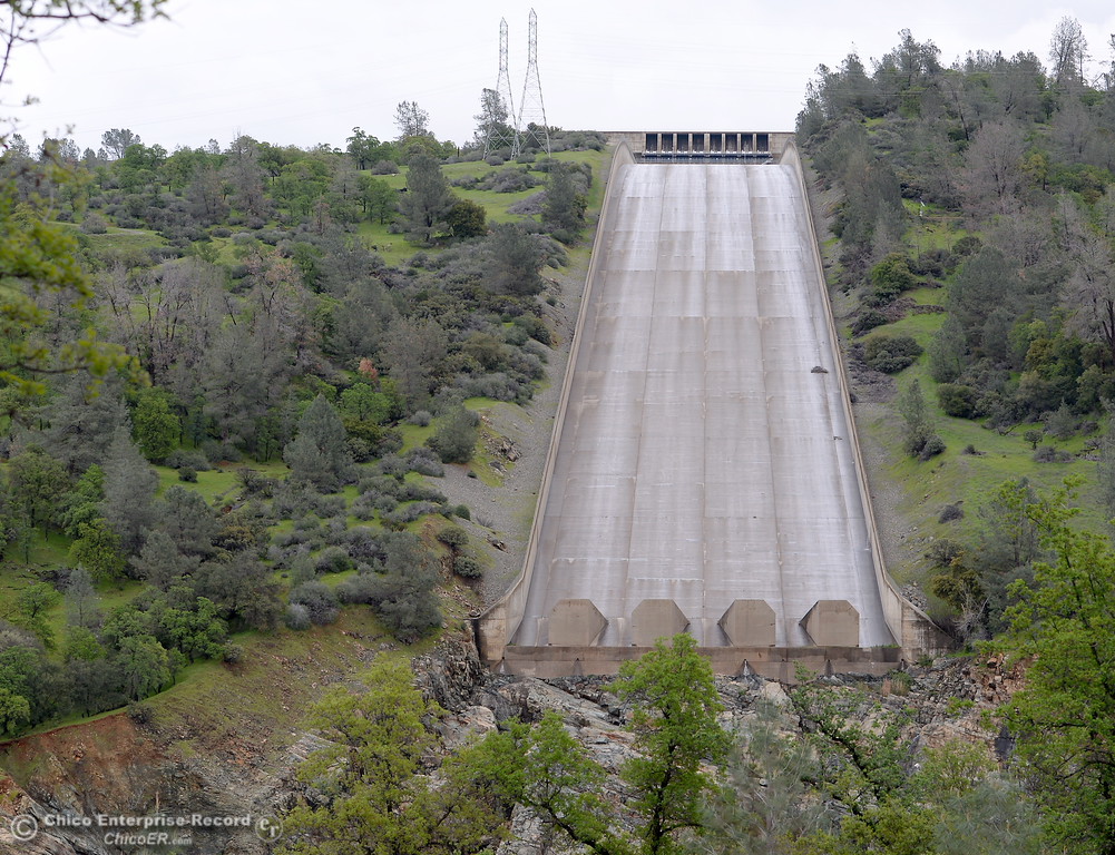
But of particular interest is this one labeled 2016-05-02
20170218-074913-hhytq.jpg

20170218-074913-hhytq.jpg

Appears to show some turbulence at the spot where the damage occurred.

This type of turbulence also occurs in one other spot near the bottom.
20170218-075219-hqeqg.jpg

Like the hole area, this lower turbulence area also shows a quite large repair
20170218-075744-qgwfo.jpg

This lower damaged area was still visible after the upper hole formed, and was visible during the first stoppage:

20170218-081207-cwli9.jpg

20170218-080806-t2dph.jpg

Some information about joints in concrete slabs from the Federal Highway Administration.

https://www.fhwa.dot.gov/pavement/t504030.cfm

Technical Advisory T 5040.30 Concrete Pavement Joints

The performance of concrete pavements depends to a large extent upon the satisfactory performance of the joints. Most jointed concrete pavement failures can be attributed to failures at the joint, as opposed to inadequate structural capacity. Distresses that may result from joint failure include faulting, pumping, spalling, corner breaks, blowups, and mid-panel cracking. Characteristics that contribute to satisfactory joint performance, such as adequate load transfer and proper concrete consolidation, have been identified through research and field experience. The incorporation of these characteristics into the design, construction, and maintenance of concrete pavements should result in joints capable of performing satisfactorily over the life of the pavement. Regardless of the joint sealant material used, periodic resealing will be required to ensure satisfactory joint performance throughout the life of the pavement. Satisfactory joint performance also depends on appropriate pavement design standards, quality construction materials, and good construction and maintenance procedures.​
 
All the photos labeled USGS (that one is a clip of an earlier one) are from:
https://earthexplorer.usgs.gov/

There's no way of linking directly to the originals. You have to specify an area search and then down load 80MB zipped TIFF files.
20170218-101753-hg7tv.jpg

Select a data range and dataset, and limit it to HD downloads.
 
here's a fun old video of the construction 50 years ago.

Source: https://www.youtube.com/watch?v=p_5udzKfLQM


The last 15-20 seconds of this PR video shows the lake level at the very top of the inlet walls to the main spillway and the discharge flowing so high that it appears to overtop the spillway side walls just down hill from the gates.

The damage may have started from this publicity stunt near the time of the dam's completion. Can anyone identify the date of these images from the unusually high water and discharge rate?
 
here's a fun old video of the construction 50 years ago.

Source: https://www.youtube.com/watch?v=p_5udzKfLQM

The last 10 or so seconds of this video appear to show the lake water level near the top of the dam and the outflow from the spillway at a very high rate. The standing wave just below the gates looks like it is overtopping the spillway side walls.

Can the date of this PR stunt be determined from the high lake level and the high discharge rate? Both must be very rare events.

Edit to add: Perhaps the damage was started when this video was shot near the dam's completion.
 
The standing wave just below the gates looks like it is overtopping the spillway side walls.
i imagine overspray is factored in and the reason they build the draining systems on the side.

Not sure you can "PR Stunt" a full reservoir.
 
Not sure if this is the right thread or if this should go in the main thread:

I think there's evidence that the ES experienced very minor flow during the Jun 2011 high pool event. Open this image full size and check out all of the debris sitting on the downstream side of the ES weir, which matches the color of deposits at the extreme left of the image on the reservoir side. The image is from 26 Jun 2011:

OrovilleWeirOvertopJun2011.jpg

Now compare that to 13 days earlier:

OrovilleWeirPreOvertopJun2011.jpg

Reservoir elevation covering those two dates:

chartviewer.png
 
I think there's evidence that the ES experienced very minor flow during the Jun 2011 high pool event. Open this image full size and check out all of the debris sitting on the downstream side of the ES weir, which matches the color of deposits at the extreme left of the image on the reservoir side. The image is from 26 Jun 2011:

I agree, looks like it got half an inch or so over. Minor erosion, and the water probably just went through the drainage channel under the road.
20170218-164821-3asxf.jpg
 
Saw mentioned somewhere that 2015 report noted tree located close to spillway wall they recommended be removed ...

This sure looks like could be that tree ... 'trees like water' ... and this one is close to wall and taller than nearby.

It also appears almost exactly where the the non-operable drain is on that side and diagonally downstream from the non-operable drain on opposite wall.

With my belief that the drain system is "charged" with water during flow events - what is the reason a drain would not flow into the reservoir? Plugged or broken. A broken pipe would leak water ... and create moist soils ... a trees best friend.

Image was posted by diedre ...

MainSpillwayTree2014.jpg
 
I bought and scanned the 1967 postcard found by @JCL, and it shows a bit more detail
20170222-142730-m49qg.jpg
The pattern makes it bit hard to zoom in on:
20170222-143410-6fh81.jpg

but adding some blur and contrast
20170222-143610-dzngk.jpg

There's certainly something going on in that area that might indicate some pre-existing weakness.

Here's the full spillway, adjusted to bring out detail in the concrete surface.
20170222-144516-5kaaw.jpg

If anyone wants to try to extract more, here's a 1200dpi PNG scan (69MB)
https://www.metabunk.org/sk/1967_Oroville_Postcard_1200_DPI_Raw.png
 
Last edited:
And this is just a more web-friendly slightly adjusted version of the full postcard
1963 Oroville Postcard 1600px.jpg

This probably contains 99% of the information of the larger one.
 
Last edited:
Anyone know what the "spillway" in the upper right, upstream of the dam is?
I believe that's where the screened intake pipes for the water going into the dam power plant are. They are lower than in the pic, but I can imagine back then that the earth was scraped all the way down to where they are, as a consequence of installing them. And, at the time of this pic, they may not been have been installed yet.
 
Hello everyone. I'm new here. I want to thank everyone for contributing.

I dont have much to add but I want to show this picture I found a few years back. It shows patches all over the spillway and a LOT of repair where the slabs join. I dont even have to add circles or arrows they are clearly visible. The worrisome part is that is VERY close to the gates.

august 2014
 
Last edited by a moderator:
If the spillway had 'leaked' in some spots previously, there may have been a wash-out below the concrete surface further down.
So any previous damage above the failure area would likely have added to the current event. Am I correct?
 
Here's the spillway on Sept 5, 2014. This is a few hundred feet above the actual damage section. Note a variety of cracks and repairs
20170216-141208-mgzp0.jpg

Here are similar cracks just below the hole

20170216-142135-yljzh.jpg

The cracks that are not slab joints appear to be in a "herringbone" pattern to me.

The image below from wrorke post (https://www.metabunk.org/oroville-dam-spillway-failure.t8381/page-24#post-201197) appears to show a drain pipe at the center with a "herringbone" crack leading off to the upper left. There appear to be similar cracks equally spaced above and below with the lower one possibly ending in another pipe.

upload_2017-2-17_18-38-9.png


Also several images of the "hole" appear to show part of the lower edge aligning with these "herringbone" cracks, several of which are visible in the sample below.

 
Take a look at the upper image in Post 64, above. Look closely at the two broken edges where the concrete surface has sheared/ripped/slipped off its substrate. There are no apparent pieces of rebar but note the parallel groves in the substrate a few inches apart running in the spillway longitudinal direction. They look to me to be impressions remaining from rebar which has been pulled from the slab as the lower slab pieces washed away. They appear to be just barely below the surface of the slab, positioned at a depth within the slab so shallow as to provide minimal reinforcement. If so, an element of the spillway failure may have been inadequate concrete due to improper positioning of the rebar within the slab. (Perhaps the rebar crew built the cage too high, then the concrete pourers poured to the form line notwithstanding that barely covered the rebar.)
 
Last edited:
I colorized the photo above at:

http://demos.algorithmia.com/colorize-photos/

Then compared to Google Earth for a then vs now. They are quite badly misaligned, but some of the roads on either side are the same and can be used for orientation:


Attachments

  • upload_2017-2-25_19-7-33.png
    upload_2017-2-25_19-7-33.png
    345.6 KB · Views: 420
  • upload_2017-2-25_19-9-5.png
    upload_2017-2-25_19-9-5.png
    2.2 MB · Views: 466
Last edited:
Google Earth has imagery dated July 9, 2010 that clearly shows crack patterns on the spillway surface. There doesn’t seem to be spill flow at that time but the entire spillway deck looks wet. That wet condition accentuated differences in surface materials, such a patching materials and voids on regular concrete. The imagery can be found by inserting “Oroville dam” in the Google Earth search box and then selecting the date with the “Historical Imagery” slider.

I’ve attached three sample screen grabs of views at the top, the failure area, and the bottom of the spillway. “3D” settings and view perspectives were chosen to minimize distortion of patterns on the spillway deck.

The spillway deck displays a pattern of cracks (or patches of cracks) that is fairly consistent in orientation and spacing over the entire length of the spillway. Most cracks run from side to side across the width of the spillway with relatively little cracking aligned along the spillway. Spacing between visible side-to-side cracks averages roughly 20-25 ft. Some areas of cracks appear in shallow herringbone patterns – the area where the spillway failed is a good example. Note that such patterns are not uniformly consistent and it’s not clear at the moment whether they have any relationship to a construction feature like drain channels under the deck. Cracking in the area where the deck failed doesn’t look notably worse than several other areas of the spillway. Unrepaired surface spalls are visible at several cracks and joints along the spillway. Outlines from the original concrete pours (40’x50’ rectangles) are visible and don’t seem particularly related to crack patterns.

The relative consistency of crack patterns throughout the spillway suggests it might not have resulted from flow forces or bedrock conditions that would be different from place to place. Rather the pattern might result from something in the design or in the construction process, or perhaps from conditions applied evenly over the extent of the spillway such as thermal cycling.


Top of Spillway
July 9 2010 top.jpg


Area of Spillway Failure
July 9 2010 failure area.jpg


Bottom of Spillway
July 9 2010 bottom.jpg
 
CRM114's reddit image led me to the the Holy Grail page boys and girls ... a spectacular collection of construction images!

https://www.facebook.com/groups/OrovilleDamBuilders/
Lots of really good pictures there, thanks for the link. Here are a couple more of interest.

View up the spillway from the river (maybe someone clever can do a comparison to the view now?):


Intersting view of emergency spillway weir mid construction:


Attachments

  • up_spillway.jpg
    up_spillway.jpg
    149.9 KB · Views: 433
  • emergency_spillway.jpg
    emergency_spillway.jpg
    119.4 KB · Views: 509
I will have to leave it to someone more expert to provide a before and after slider image combining these two scans (I've done it on a mobile device but can't upload it). In both the earlier photo is on the left. I have also applied color to the first pair to get a better contrast:

2_Compare.jpg

1_Compare.jpg

I think it's already been observed that the earlier image appears to show some kind of landfill at the point of the spillway failure. Enlarging the image appears to show two vehicles there, maybe scrapers - in which case what's there might not be fill but actually topsoil in the process of being removed.

The picture on the right clearly shows the site preparation at a later stage. Both above and below the failure point there are what appears be rock outcrops but between them is an area that is lower. In fact, in that area the terrain appears to undulate including right at the point of the failure. Looking close up at the view of the spillway site in post #72 above - which bears a date about a month before the left photo, that undulation is also evident within the area I have roughly marked in red:

3_UpChute.jpg

This is at least consistent with the substratum below the spillway failure point not being the same solid rock that lies above and below it. Somewhere there must be documentary record of whether this was the case or not and if it was, how the difference was dealt with.

P.S. The Facebook page from which these images are sourced contains a vast number of images of the construction process. One of them was particularly sobering as it reflects the fact that 34 men died in the course of building this dam, which is something to be borne in mind when trying to stitch together an explanation of the present situation.
 
Google Earth has imagery dated July 9, 2010 that clearly shows crack patterns on the spillway surface. There doesn’t seem to be spill flow at that time but the entire spillway deck looks wet.

Great find. There is minute flow at the lip of the energy dissipator at the bottom of the spillway. I'd guess flow had just been shut off. The conditions are seemingly perfect for identifying these features, and from other closer up photos, they do seem to be cracks at least in the damaged area:

https://www.metabunk.org/pre-failur...ay-historical-images.t8410/page-2#post-202233
https://www.metabunk.org/oroville-d...lls-how-do-they-work.t8407/page-4#post-202357

The relative consistency of crack patterns throughout the spillway suggests it might not have resulted from flow forces or bedrock conditions that would be different from place to place. Rather the pattern might result from something in the design or in the construction process, or perhaps from conditions applied evenly over the extent of the spillway such as thermal cycling.

There are many causes of cracking in concrete:

http://theconstructor.org/concrete/prevent-cracks-in-concrete-structures/13457/


It would be nice to know whether cracks formed right after the hardening or later to narrow it down. Shrinkage is often cited as the most common cause. Concrete can shrink 1/4 inch per 100 feet.

Based on an hydraulic design study, the slab is less thick over the drains and that could have an influence:

https://www.metabunk.org/oroville-d...lls-how-do-they-work.t8407/page-4#post-202106

upload_2017-2-26_10-32-30.png

The rock anchors, acting as fixed points are also a possibility:
upload_2017-2-26_10-38-20.png

Note they are spaced at 10 feet, at least in the design study. Depending on the cause of the cracks, they could have also have influence on the pattern.
 
You would expect to see rebar everywhere.

It's there. In the big pieces that broke off and went down the new gorge.

Simple rebar lap joints, so the embedded rebar will stay with the piece that has the most secure embedment.

You can see the grooves in the top piece that is still a part of the spillway where the rebar used to be...
 
Take a look at the upper image in Post 64, above. Look closely at the two broken edges where the concrete surface has sheared/ripped/slipped off its substrate. There are no apparent pieces of rebar but note the parallel groves in the substrate a few inches apart running in the spillway longitudinal direction. They look to me to be impressions remaining from rebar which has been pulled from the slab as the lower slab pieces washed away. They appear to be just barely below the surface of the slab, positioned at a depth within the slab so shallow as to provide minimal reinforcement. If so, an element of the spillway failure may have been inadequate concrete due to improper positioning of the rebar within the slab. (Perhaps the rebar crew built the cage too high, then the concrete pourers poured to the form line notwithstanding that barely covered the rebar.)

That looks to be well within code. Keep in mind it's a 15" slab if I remember correctly; it is supposed to have 2" of cover depending on the side of the slab (exposed to weather, or 3" if cast against earth, in the case they used 2 layers of steel, or at the construction / expansion joints). It is placed where you would want it for it's intended purpose- temperature and shrinkage cracking.

To get to minimum steel of 0.0020 or 0.0014 (not sure what steel they used), if it is 15" thick would require #6 @ 14" O.C. top only. Looks about like what is in the pictures, and matches the detail shown above.

Everything I see in the pics points to a compliant design constructed correctly- but I'll leave that seal up to the licensed engineers!

Also note in detail A that the dowel is wrapped to prevent bonding on the top side- this is normal, allows for temperature and shrinkage expansion and contraction. But if the subbase under the bottom panel erodes and is no longer there to support the panel, it will drop out and slide away from the top panel unrestrained. And then you will see what happened here, a relatively clean line across the top of the failure, and a big mess on the bottom edge of the hole.

There was probably a similar detail along the sides to allow movement without compromising the walls. Keep in mind, this thing is something like 180 feet wide, 2/3 of a football field! So when panels started to drop out, the left side was still somewhat supported and the panels broke off irregularly, exposing where the rebar was, and across the top and right side, the dowels simply pulled out of their slots.

Interesting how things behave when they fail, even when behaving exactly as designed and intended- intentionally allowing movement of the slab.
 
Last edited:
Status
Not open for further replies.
Back
Top