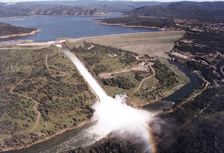
Oroville Dam Spillway Failure

Status
Not open for further replies.
I wonder if they have ever considered relocating the spillway entirely to one of those more distant saddles below lake level than the one they used next to the dam?

The problem with that is the distance they are from the river. There's really no way of getting the water there across the flat land. Not really a possible solution to anything.
 
Are we certain there is high quality rock under the weir's footing for its entire length?

Comparing the design blueprints and spillway test models posted earlier: the actual photos appear to show deviations.

The closest I have come is the State Water Project book, page 133, where it says an additional 10' of excavation was needed to get down to acceptable bedrock for the Espill weir. The key to your question is "it's entire length", that we don't know for sure but I would guess that if they worked that 10' down it was so the whole weir was on acceptable bedrock...The big question for me is what that acceptable bedrock was? It talks about the main spill gates having odd rock formations unlike the bottom slope that they air blasted. So does that mean that top slope with odd rock continue the length of the Espill weir?
 
Here's the lake level for the last two years
20170218-162901-htl4n.jpg
So if they were okay with last year they could aim to draw it down to 750, just to be on the safe side. Of course that would need the power station working, and would take at least a couple of months to get there. I suspect they would want to just keep letting out as much water as possible until may.

Its more interesting to look back to 1995 ... appears the reservoir has been to 900' many times ... the number and share of time above 850' is small, but these levels aren't seemingly unprecedented ...

OrovilleDamLevels1995-2017.jpg
 
The closest I have come is the State Water Project book, page 133, where it says an additional 10' of excavation was needed to get down to acceptable bedrock for the Espill weir. The key to your question is "it's entire length", that we don't know for sure but I would guess that if they worked that 10' down it was so the whole weir was on acceptable bedrock...The big question for me is what that acceptable bedrock was? It talks about the main spill gates having odd rock formations unlike the bottom slope that they air blasted. So does that mean that top slope with odd rock continue the length of the Espill weir?
Good point about "... acceptable bedrock...".

It would be great if someone took core samples to verify exactly what is under the length of the weir.

If it's good quality rock: the design and installation of the weir (emergency spillway) and spillway look good and a lot of examples on short-term and long-term corrective action makes sense.

If the rock under the weir is not good quality: have to question many assumptions.
 
Its more interesting to look back to 1995 ... appears the reservoir has been to 900' many times ... the number and share of time above 850' is small, but these levels aren't seemingly unprecedented ...

OrovilleDamLevels1995-2017.jpg

The images of the 1997 release that scoured the far wall of the plunge pool look impressive. Are there any higher resolution? All I can find are very low. The water flow appears to be far greater than anything we have seen this year but the image was apparently scanned with a potato :p
 
There's something I don't really understand. At first, when the emergency spillway was used, we saw large amounts of erosion. The damaged main spillway was then used again to relieve the emergency spillway. The managers did so, knowing they would destroy their damaged spillway under that force of water.

It took this community a couple of days to find enough old drawings and documentation to show that the weir is solidly anchored to bedrock, and is so heavy that the water won't force it from its place. Assuming a well functioning archive, you'd expect the managers of the dam to have had that info within minutes to a couple of hours. What then did make them fear for a failure of the top of the emergency spillway, if the erosion couldn't have undercut the weir?
 
There are 2 dams, one north and one south, that could be opened to release some of the upper lake level.saddle dam locations in GE.jpg

Nether has a channel designed for it, would be disastrous for the immediate downstream communities, but the option is there to spread the flow to 2 different areas far away from the dam. One would empty into Bidwell Canyon and the other drain south into a creek system. Bidwell Canyon saddle dam foot is apparently at 875 feet in relation to the main spillway, Parish camp foot is at the 895 foot level. According to the Height from base and Crest elevation for both from the following PDF. Both crest at 922 to match the main dam.

I have no idea if it is at all possible, but the south dam Bidwell Bar Canyon Saddle Dam is to very flat terrain relative to the spillway. It may be totally wrong to do this, it would be essentially the same horrible situation of potential back cut into the reservoir, but if that was actually taking place at the spillway the south saddle dam seems like it would flood the least individual landowners before entering the yuba watersheds management system.

I wonder if they have ever considered relocating the spillway entirely to one of those more distant saddles below lake level than the one they used next to the dam?

Also, I got confused in GE as Parish camp Saddle Dam empties into Bidwell Canyon and Bidwell Bar Canyon Saddle Dam empties to the south foothill slopes, creeks leading to the yuba river. It seems a bit odd how they are named but the documents confirm the locations.

2.1.3 Saddle Dams Saddle Dams include Bidwell Canyon and Parish Camp and complement Oroville Dam in containing Lake Oroville. Bidwell Canyon Saddle Dam is located two miles southeast of Oroville Dam, consisting of two separate embankments. Parish Camp Saddle Dam is located on the West Branch arm of the reservoir and is 12 miles north of Oroville Dam.
Content from External Source
Table A.2.1-3.
Saddle dams technical data. Bidwell Canyon Saddle Dam
Type Earth and rockfill
Height from Base of Dam 47 ft
Crest Elevation 922 ft msl
Crest Width 30 ft
Crest Length 2,270 ft
Embankment Volume 175,000 cubic yards
Side Slope 2.5:1

Parish Camp Saddle Dam
Type Earth and rockfill
Height from Base of Dam 27 ft
Crest Elevation 922 ft msl
Crest Width 30 ft
Crest Length 280 ft
Embankment Volume 11,000 cubic yards
Side Slope 2.5:1
Source: DWR Bulletin Number 200 – Volume III and Final Construction Report
Content from External Source
PDF here
Excellent research! The same thought occurred to me, about using saddle dam as an alternative - but I hadn't had the time to fully research it. Great work!
 
There's something I don't really understand. At first, when the emergency spillway was used, we saw large amounts of erosion. The damaged main spillway was then used again to relieve the emergency spillway. The managers did so, knowing they would destroy their damaged spillway under that force of water.

It took this community a couple of days to find enough old drawings and documentation to show that the weir is solidly anchored to bedrock, and is so heavy that the water won't force it from its place. Assuming a well functioning archive, you'd expect the managers of the dam to have had that info within minutes to a couple of hours. What then did make them fear for a failure of the top of the emergency spillway, if the erosion couldn't have undercut the weir?
Good question. My guess would be the two questions that people here keep coming up with--concerns over the quality of the bedrock (i.e. a lot of easily eroded, weathered bedrock, or fractures) and/or concerns about the area overlain by the parking lot and how that water was eroding under the weir. Don't forget too they concreted in some boulders along the toe of the weir on the end nearest the dam, so they were clearly concerned about these sorts of issues even before using it. I have to think they had reviewed the same information that's been posted on here even before they did that.
 
Last edited:
Agreed! The amount of erosion to happen in less than 2 days was pretty insane. (Look at the huge caverns formed.) IMO, the entire hillside is just too fragile to sustain any amount of spill. Of course, now with all the shoring up, it just might hold. But we just can't bring ourselves to trust it, until it's been tested...

There's something I don't really understand. At first, when the emergency spillway was used, we saw large amounts of erosion. The damaged main spillway was then used again to relieve the emergency spillway. The managers did so, knowing they would destroy their damaged spillway under that force of water.

It took this community a couple of days to find enough old drawings and documentation to show that the weir is solidly anchored to bedrock, and is so heavy that the water won't force it from its place. Assuming a well functioning archive, you'd expect the managers of the dam to have had that info within minutes to a couple of hours. What then did make them fear for a failure of the top of the emergency spillway, if the erosion couldn't have undercut the weir?
 
Good point about "... acceptable bedrock...".

It would be great if someone took core samples to verify exactly what is under the length of the weir.

If it's good quality rock: the design and installation of the weir (emergency spillway) and spillway look good and a lot examples on short-term and long-term corrective action makes sense.

If the rock under the weir is not good quality: have to question many assumptions.


I wondered about the survey earlier, here is the actual survey extent from the PDF (PDF frame 130, doc page 78):

Exploration

Subsurface geologic exploration was
initiated by the U. S. Army Corps of Engineers in
1944 with the drilling of two core holes, one on each
abutment.

In 1947, the U. S. Bureau of Reclamation
drilled six core holes at the site. Explorations by the
Department of Water Resources were begun in 1952
and those required for design were completed in 1959.

They included the following:

1. Exploratory Adits—Four 5-foot by 7-foot adits
were driven, two on each abutment, together with
drifts and cross cuts, totaling 5,251 linear feet.

2. Core Borings—175 borings were drilled varying
in size from EX to NX, and in depth up to 200 feet,
totaling 18,600 linear feet.

3. Seismic Surveys—Supplementing a "depth of
weathering" survey by the U.S. Bureau of Reclamation
in 1950 was a 1957 program consisting of 4,350
linear feet of spreads to determine modulus of elasticity
and depth of weathering.

4. Special Studies—Detailed evaluation of bedrock
properties was made by carrying out the following
special investigations:

a. X-ray diffraction and solubility tests on clay
gouge in shear planes

b. Compression tests on rock cores

c. Studies of blasting effects in the diversion tunnels

d. Test grouting

e. Rock-joint attitude mapping

f. Measurement of ground water levels and
spring flows

g. Bedrock-stripping methods, eliminating ripping
and blasting

h. In situ rock modulus tests
Additional information was gained from exploration
for the underground powerplant and other structures.
Content from External Source
(Edited:Spacing of quote for readers eyes comfort)
 
Last edited:
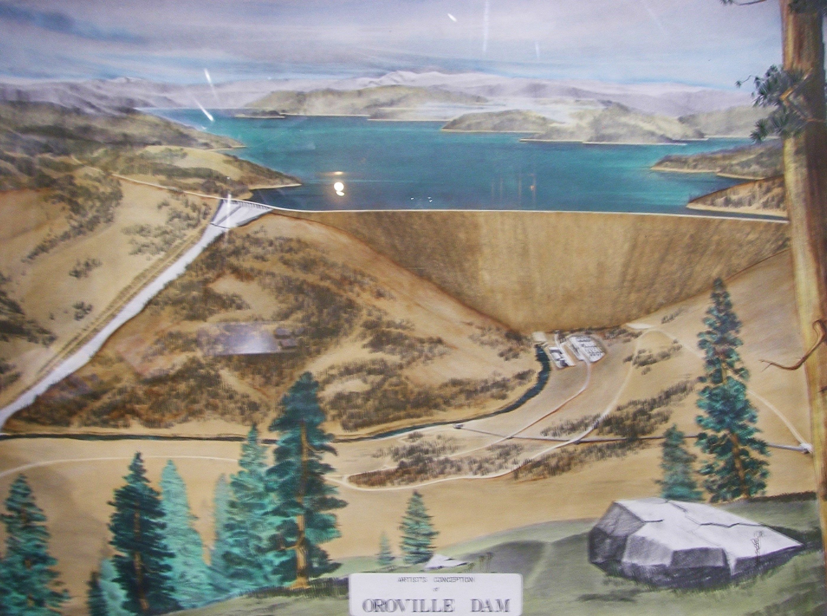
There's a painting of the dam at the visitor center that appears to show a design with:

a) The larger, combined outlet works you mention (including concrete apron for what I guess would be proper auxiliary flood control)

b) An unlined spillway channel

c) A spillway alignment closer to east-west than the current alignment, proceeding directly down the sub-saddle valley


Interesting picture ... I believe I saw plan sets that included that addtl spillway into the main channel ... and in fact the main spillway end of the emergency weir appears to be graded exactly for the additional spillway.

AuxiliarySpillway.jpg
 
What does the 15" rain event refer to? Is that a peak or a basin-wide average?

I compute 670K ac ft as equivalent to 5-6 inches as a basin-wide average.

Various sources reported the 15" storm event resulted in an appx 670,000 ac feet actual increase in the reservoir ... we can also measure from the inflow data:

Jan event total inflow: ac ft
1/8/2017 10:00 PST: 2,103,675
1/11/2017 13:00 PST: 2,692,044 increase from 1/8/17 = 588,369
1/12/2017 14:00 2,782,547 increase from 1/8/17 = 678,872


http://cdec.water.ca.gov/cgi-progs/queryF?s=ORO&d=18-Feb-2017+16:55&span=1200hours
 
Last edited:
There's something I don't really understand. At first, when the emergency spillway was used, we saw large amounts of erosion. The damaged main spillway was then used again to relieve the emergency spillway. The managers did so, knowing they would destroy their damaged spillway under that force of water.

It took this community a couple of days to find enough old drawings and documentation to show that the weir is solidly anchored to bedrock, and is so heavy that the water won't force it from its place. Assuming a well functioning archive, you'd expect the managers of the dam to have had that info within minutes to a couple of hours. What then did make them fear for a failure of the top of the emergency spillway, if the erosion couldn't have undercut the weir?

I do not agree with others assessment that the erosion could not have undercut the weir. I believe it was in the process of doing just that. The photographic evidence of the cut mere feet from the front of the weir seems to indicate that to me. I believe the weir would have been undercut if it was used much further, I do not know how much that cut would have expanded. I do suspect that if it had gone further it would not have ripped out the whole structure but added an increasing uncontrolled amount under the 901 elevation of the top of the weir, somewhere around 880 given the height of the weirs base at that area. I suspect it would have been under 10,000 cfs through a gap and that draw down efforts would have eventually dropped the lake below that mark as it is right now. A cut would only help them draw the lake level down.

I think it was in danger of undercut, but not for total failure as the rock has strong and weak areas and would take some time to cut the bedrock below the weir into a large opening. Just like the portion of the main spillway that is still in place despite the enormous beating its taking on its uphill edge, the weir concrete would not collapse and the area eroded under it narrow enough that it would remain in place and still channel waterflow over and through a narrow gap under it.
 
Good point about "... acceptable bedrock...".

It would be great if someone took core samples to verify exactly what is under the length of the weir.

If it's good quality rock: the design and installation of the weir (emergency spillway) and spillway look good and a lot of examples on short-term and long-term corrective action makes sense.

If the rock under the weir is not good quality: have to question many assumptions.

It's interesting that there seems to be a consensus on here that the ESpill was a last resort and was never expected to be used-see tree lined spillway. But there is some serious planning and work that went into building the weir and I wouldn't be surprised if they took core samples and that is what told them they were on "acceptable bedrock". Serious planning and work to me could be a small project to them like and I don't want to assume since they dug 10' down that it was considerable work, it does seem to me this was a "must have" but an afterthought and something they probably thought when building it "those bureaucrats are making us build this thing but there is no way in hell they will ever use it". Think about it, they just spent years building the dam and main spillway, do you think a lot of their focus would have been on a fail safe? I think we might learn it was an afterthought and not nearly as much planning went into building it as the main dam and spillway was....I hope I am wrong...
 
Excellent find. Somewhere also is the data, mapping and likely cross sections from all that work.
#1058 "....a. X-ray diffraction and solubility tests on clay gouge in shear planes." ???? What's this about???
 
Various sources reported the 15" storm event resulted in an appx 670,000 ac feet actual increase in the reservoir ...

Pretty sure that's some kind of peak, and not basin-wide, as that would nearly equal the PMF. I'd like to get ahold of cumulative precip for that storm, because I'm coming up with numbers in the 800,000 ac-ft range for this upcoming storm.
 
It's interesting that there seems to be a consensus on here that the ESpill was a last resort and was never expected to be used-see tree lined spillway. But there is some serious planning and work that went into building the weir and I wouldn't be surprised if they took core samples and that is what told them they were on "acceptable bedrock". Serious planning and work to me could be a small project to them like and I don't want to assume since they dug 10' down that it was considerable work, it does seem to me this was a "must have" but an afterthought and something they probably thought when building it "those bureaucrats are making us build this thing but there is no way in hell they will ever use it". Think about it, they just spent years building the dam and main spillway, do you think a lot of their focus would have been on a fail safe? I think we might learn it was an afterthought and not nearly as much planning went into building it as the main dam and spillway was....I hope I am wrong...

I have wondered such things but in reality it could equally have been the job of an up and coming young engineer with a lot of talent that did not get as much input as would have liked on the main dam, and did the job on the emergency spillway far better than average. There is just no way to know about things like that and while I wholeheartedly agree that government is sort of incompetent in a general sense, engineers do it because they are into it and think it's cool mostly, and most care about their engineering.
 
Pretty sure that's some kind of peak, and not basin-wide, as that would nearly equal the PMF. I'd like to get ahold of cumulative precip for that storm, because I'm coming up with numbers in the 800,000 ac-ft range for this upcoming storm.

I think it was just the ORO station, which looks like it gets more than the areas to the east.
 
Good point about "... acceptable bedrock...".

It would be great if someone took core samples to verify exactly what is under the length of the weir.

If it's good quality rock: the design and installation of the weir (emergency spillway) and spillway look good and a lot of examples on short-term and long-term corrective action makes sense.

If the rock under the weir is not good quality: have to question many assumptions.

Core samples were taken at the time ... regardless we know the builders when to additional expense and effort, overcutting as much as 10 feet in areas and backfilling with cement, to insure good bedrock as a foundation for the emergency weir.

It is silly to think they would note this extra effort and expense and then half-ass it on what they considered good bedrock.

You can also read this thread and find the dozens of examples that clearly show good, blue-green bedrock that has been exposed just below the surface in pretty much all areas ...
 
All else aside, it seems a 12,000cfs flow for a very short time is at least an order of magnitude below a test that reflected storm inflow rates. I'm glad for what it has shown, but I also suspect more severe tests might show additional results.
 
Think about it, they just spent years building the dam and main spillway, do you think a lot of their focus would have been on a fail safe? I think we might learn it was an afterthought and not nearly as much planning went into building it as the main dam and spillway was....I hope I am wrong...
except if their weir collapsed it would release 30 feet of water and their reputations would have been shot. I trust thier egos to have planned it fairly well.
 
I do not agree with others assessment that the erosion could not have undercut the weir. I believe it was in the process of doing just that. The photographic evidence of the cut mere feet from the front of the weir seems to indicate that to me. I believe the weir would have been undercut if it was used much further, I do not know how much that cut would have expanded. I do suspect that if it had gone further it would not have ripped out the whole structure but added an increasing uncontrolled amount under the 901 elevation of the top of the weir, somewhere around 880 given the height of the weirs base at that area. I suspect it would have been under 10,000 cfs through a gap and that draw down efforts would have eventually dropped the lake below that mark as it is right now. A cut would only help them draw the lake level down.

I think it was in danger of undercut, but not for total failure as the rock has strong and weak areas and would take some time to cut the bedrock below the weir into a large opening. Just like the portion of the main spillway that is still in place despite the enormous beating its taking on its uphill edge, the weir concrete would not collapse and the area eroded under it narrow enough that it would remain in place and still channel waterflow over and through a narrow gap under it.


And I disagree. The the back cut was exposed weathered surface rock. It eroded rapidly which led to the panicked decision to evacuate. Read the reports however, and almost immediately officials noted the erosion slowed.

ALL evidence shows the emergency weir is on good bedrock. The same bedrock exposed in the consolidated channel pretty much ALL the emergency spillway data flowed thru. Close to the entire flow of the 900 foot emergency weir flowed thru that narrow channel down a steep slope, and almost no erosion other than topsoil occurred.

You want us to believe the 12,000 cfs flow from 40 or 50 feet of wall above it was gone to back cut thru the same bedrock?

Sorry ... does not compute ... ;-)
 
It's interesting that there seems to be a consensus on here that the ESpill was a last resort and was never expected to be used-see tree lined spillway. But there is some serious planning and work that went into building the weir and I wouldn't be surprised if they took core samples and that is what told them they were on "acceptable bedrock". Serious planning and work to me could be a small project to them like and I don't want to assume since they dug 10' down that it was considerable work, it does seem to me this was a "must have" but an afterthought and something they probably thought when building it "those bureaucrats are making us build this thing but there is no way in hell they will ever use it". Think about it, they just spent years building the dam and main spillway, do you think a lot of their focus would have been on a fail safe? I think we might learn it was an afterthought and not nearly as much planning went into building it as the main dam and spillway was....I hope I am wrong...

Once again ... do you really think these people spent a decade or more designing this massive project ... years constructing it, and then they would treat potentially the most important safety aspect of the entire project as not worth their time to do right?

C'mon ...
 
BUCKS LAKE SWE 17-02-2017 12-32-47 AM.jpg
Pretty sure that's some kind of peak, and not basin-wide, as that would nearly equal the PMF. I'd like to get ahold of cumulative precip for that storm, because I'm coming up with numbers in the 800,000 ac-ft range for this upcoming storm.

Is that 800,000 ac-ft range estimate for quantity of rainfall only or does the model include accelerated snowmelt?
A great many of the stations within the watershed show significant significant amounts of Snow Water Equivalent (SWE). Fresh snow may be up to 90% entrained air. This late in the season, after a number of melt/freeze cycles, and the effects of the January storm, there is much as 36" of SWE.
 
Last edited:
Well as I said I believe the photos of the existing cut are evidence that is not the case. We can agree to disagree, I agree to that.

Sorry - but there is zero evidence that has been presented here than shows in any way the weir is on anything but the bedrock as noted in the documents.
 
Might use of saddle dams explain some of the sudden inflow fluctuations in the hourly dam data over the past week?
 
Pretty sure that's some kind of peak, and not basin-wide, as that would nearly equal the PMF. I'd like to get ahold of cumulative precip for that storm, because I'm coming up with numbers in the 800,000 ac-ft range for this upcoming storm.

The numbers directly from the Oroville reservoir data - including a link to the data. the inflow from the early January rain event - which has been reported to be a 15" storm in the general area - are what I posted. 15" may not have fallen directly on the reservoir, but is what was generally reported for the storm.

Again - that data is there and pretty easy to verify. These are the actual increase in the reservoir. I would not be at all surprised if they do not necessary exactly match calculated numbers, due to numerous outside factors that affect how much of the rainfall makes it to the reservoir?
 
My guess as to the reason for re-opening the main spillway (rather than running the emergency spillway) is that the engineers were asked by CalFire and the Sheriffs Department "are you 200% sure that the erosion on the emergency spillway will not undercut and erode the weir?" and they answered "We do not think that will happen", so the Sheriff ordered the evacuation "out of an abundance of caution" (hard to get re-elected if you opponent is running ads saying something like "Sheriff X delayed calling for an evacuation and as a result people died").
If they went through the trouble of digging down 10 feet to find "competent bedrock" I suspect that they made sure it was the blueish hard rock that has been holding up so well on what's left of the main spillway.

Aaron Z
 
Sorry - but there is zero evidence that has been presented here than shows in any way the weir is on anything but the bedrock as noted in the documents.
And the documents, both the original report and all geologic surveys, show the sheeted dyke system is interlaced with shear zones and weak areas.
 
Once again ... do you really think these people spent a decade or more designing this massive project ... years constructing it, and then they would treat potentially the most important safety aspect of the entire project as not worth their time to do right?

C'mon ...
Obviously it wasn't planned as good if they rated it for 250k CFS and it failed under 12k CFS in under 2 days. This makes me question if they spent the time to do it right. Or do you think they spent all of the time and were wrong about the hillside?
 
except if their weir collapsed it would release 30 feet of water and their reputations would have been shot. I trust thier egos to have planned it fairly well.
All I can ask is if they planned it so well why did it fail in less than 2 days?
 
All I can ask is if they planned it so well why did it fail in less than 2 days?
Short answer is, it didn't fail. There was concern about cutback, but it's not clear that concern was warranted (hindsight is clearer than what the authorities understood in the heat of the moment) - and at no point did the emergency spillway "fail" (e.g., allow water below 901' to escape the impoundment).
 
Obviously it wasn't planned as good if they rated it for 250k CFS and it failed under 12k CFS in under 2 days. This makes me question if they spent the time to do it right. Or do you think they spent all of the time and were wrong about the hillside?
The issue there is if the original intent was held, I think both Scott and I actually agree on that. the original design was for an epic flood that made downstream erosion a non factor. the numbers of CFS for the use of the 'emergency' weir are staggering, the numbers of CFS used in this incident are not 'emergency' they are 'cost cutting due to damage of the main weir'.
 
The numbers directly from the Oroville reservoir data - including a link to the data. the inflow from the early January rain event - which has been reported to be a 15" storm in the general area - are what I posted. 15" may not have fallen directly on the reservoir, but is what was generally reported for the storm.

Again - that data is there and pretty easy to verify. These are the actual increase in the reservoir. I would not be at all surprised if they do not necessary exactly match calculated numbers, due to numerous outside factors that affect how much of the rainfall makes it to the reservoir?

What falls at any single station, including the reservoir isn't a good gauge of what flows into the reservoir, since the drainage basin is a whopping 3600 square miles. But I am finding the basin-wide data I need.
 
Status
Not open for further replies.
Back
Top