deirdre
Closed Account
sure it is! what's wrong with these whimpy reporters these days? i dont want to wait 3 or so more days to see what the hole looks likeand pictures aren't worth someone sliding down into the spillway to get

")

sure it is! what's wrong with these whimpy reporters these days? i dont want to wait 3 or so more days to see what the hole looks likeand pictures aren't worth someone sliding down into the spillway to get
It is not like they have been able to get close without risking getting washed downstream or sliding down the hill.
well this shot is fine you can see the edge perfectlythe minute mark
i guess we'll know when the outflow stops just how bad they 'were scamming' the public, right?
i guess. and i do know that when i'm interested in a subject it always iritates me that there isnt constant footage, so i hear you.There is definitely a level of distrust from the public, one would think they would attempt to be more opaque
I live at ground zero. The lack of good up-to-date visuals of the state of the erosion is very frustrating and nerve-wracking.
I live just a few blocks away, once the flight restrictions are lifted I'll have some drone video, I'm dying to get one of my fixed wings up.Hi Marian. I've been thinking that we're all going to be depending upon your local neighbors (with drones) to be providing updates throughout the entire reconstruction process. If you discover that happening, please announce it here.
View attachment 24878
Hard to tell, I'll let you know when my postcard arrives. It might just be a crease or mark on the postcard.
Bob Hertzberg is a state senator from southern California who was on a helicopter today.
Source: https://twitter.com/SenateHertzberg/status/834935845043892224
View attachment 25428
")
This first pic is excellent, as you can actually see the jagged outline of the slab as the water is falling over it. Great for discerning even minute changes if we get a future pic taken from the same angle.
It is. The right spillway wall looks to be leaning towards the flow. If so, there could be slab separation. I don't recall seeing that in previous photos, but it could just be the perspective.
I think that's just a combination of the curve of the spillway, perspective (wide angle lens) and the broken end of the wall normally leaning downslope. Here's a Google Earth pic from a similar viewpoint
View attachment 25462
you would need to view a pre-damage photo.I see what you mean. It's tough to tell. I added some lines for reference. I tried the same on your google pic, but it's sketchy to pick the top of wall.
In that last picture (post #192), it doesn't look like the wall is leaning.
https://www.facebook.com/bcsonews/posts/789204901229790External Quote:
SPILLWAY PRESS BRIEFING ON REDUCED OUTFLOWS TOMORROW MORNING AT 10:00 AM
Oroville, California - Tomorrow morning at 6:45 AM, the Department of Water Resources (DWR) will begin gradually ramping down outflows from the Oroville Reservoir. Flows from the flood control spillway will be reduced from 50,000 cubic feet per second (cfs) throughout the day and eventually reach zero in the afternoon.
As flows are reduced, DWR will monitor the status of the dam, spillways, and related structures to ensure their continued safety and stability. Flows will be reduced gradually to minimize risk to downstream levees. Through use of water stored in the Diversion Pool and Thermalito Forebay and Afterbay, flows necessary to meet fishery requirements in the Feather River downstream of the dam will be maintained.
Cutting off flows from the flood control spillway for several days will allow workers to aggressively attack the debris pile at its base and reduce the water level surface elevation of the channel that leads from the Hyatt Power Plant.
Removal of debris will help safeguard Hyatt Power Plant and allow for its eventual reoperation. Once operational, the Hyatt Power Plant can discharge roughly 14,000 cfs, which will allow DWR to better manage reservoir levels through the remaining spring runoff season.
Since February 12th, DWR has reduced water levels in Lake Oroville from 901 feet elevation to 842 feet, nearly 60 feet below the top of the emergency spillway. With current outflows at 50,000 cfs and inflows at only 25,000 cfs, the department will continue to create even more space in the reservoir throughout the day and overnight.
DWR Acting Director Bill Croyle and Butte County Sheriff Kory Honea will discuss these plans to reduce flows at a press briefing tomorrow morning, February 27th, 2017 at 10:00 AM. It will be held at the DWR Oroville Field Division, located at 460 Glen Road in Oroville CA 95966.
For those unable to attend, a conference line has been established. Please call (866) 508-9046 and enter the following code: 5743919. This is for listening purposes only. No questions will be taken over the conference line. The press briefing will also be streamed on DWR's Facebook page.
http://pixel-ca-dwr.photoshelter.co...I0000yYFnwfD7v7Q/KG-oroville-damage-14319-jpg
From CDWR today. The flow pattern has changed, very little water is now going down the bottom of the spillway.
i guess. and i do know that when i'm interested in a subject it always iritates me that there isnt constant footage, so i hear you.
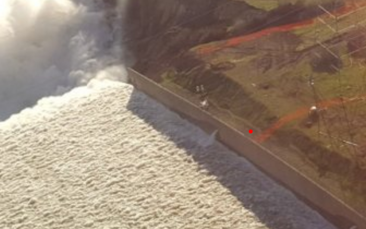
But i do personally think if the hole was breaking further up the spillway we would see evidence of that from erosion on the side (which is the point of this thread) and they would probably move those power line towers like they were planning to do.
I'm very curious to see what everything looks like too once the flow stops too.
I believe the output is still 50k CFS. The difference in flow at the bottom is likely do to different velocity. The water leaving the reservoir is now under less pressure since the level has dropped. Water is no longer squirting out, but rather flowing out.Thanks for posting this. It suggests that the flow out of the reservoir might have decreased even before the flood control structure is used to ramp it down. From the image it appears that there are two main areas of spillway collapse up- and downstream of a natural rock outcrop under the spillway deck. Will be interesting to see how deep the "cavities" are in those locations - to say nothing of what might be done to bridge or indeed use them in any repair effort.
i do know that when i'm interested in a subject it always iritates me that there isnt constant footage, so i hear you.
I live at ground zero. The lack of good up-to-date visuals of the state of the erosion is very frustrating and nerve-wracking.
If anybody could set up a live feed across from the spillway to watch the waterflows (especially today as they ramp down to zero), and the debris removal from the diversion pool, it would be awesome. Personally, I'd expect DWR to want that footage in their files.That's why we depend upon you locals, Marian
I believe the output is still 50k CFS. The difference in flow at the bottom is likely do to different velocity. The water leaving the reservoir is now under less pressure since the level has dropped. Water is no longer squirting out, but rather flowing out.
I believe the output is still 50k CFS. The difference in flow at the bottom is likely do to different velocity.