• MH370 speculation has become excessive recently. Metabunk is not a forum for creating theories by speculation. It's a forum for examining claims, and seeing if they hold up. Please respect this and keep threads on-topic. There are many other forums where speculation is welcome.

MH370 Radar sighting in Straits of Malacca debunked

Has Malaysia provided a fake radar image?


  • Total voters
    4
  • Poll closed .
Primary evidence for the alleged flight of MH370 through the Straits of Malacca is based on a claim by the RMAF, Malaysia's Air Force that they tracked a mystery aircraft on military radar from Butterworth. The original claim was that the aircraft spotted flew from IGARI to VAMPI-GIVAL-IGREX. This claim has since been abandoned.

It was abandoned after Chinese bloggers began leaking this image from a presentation to MH370 relatives at the Lido Hotel in Beijing on 21 March:


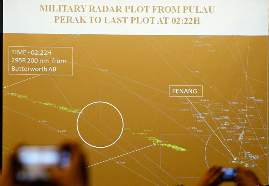
Clearly the track describes a flight from Penang across the island of Pelau Perak (18:02.48" UTC) then via VAMPI to MEKAR at 18:22 UTC. The Malaysian Government has never published the radar data however at the Lido Hotel Malaysian consular officials said this was a radar image taken by the military radar at Butterworth.

Rather oddly the image does not include two other aircraft known to be present at the same time:


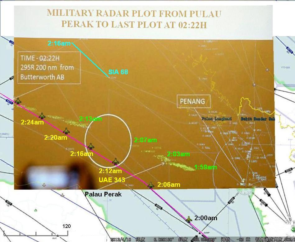
Also the image appears to be taken from the screen of a civilian SSR radar not a military radar.

That is because the umber coloured image reveals overlays of civilian waypoints, TMAs and airways flight paths. These are not features one would find reproduced on a military radar.

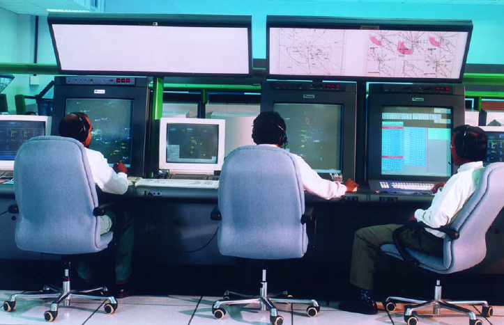
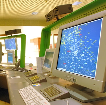
In fact we know what type of military radar which was used at Butterworth. It is a Thales Raytheon GM400. There are two identical sister Thales Raytheon GM400 systems at Kota Bharu and Kuantan on the east coast. Neither of these sister radars detected any aircraft turning back from IGARI.

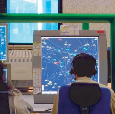
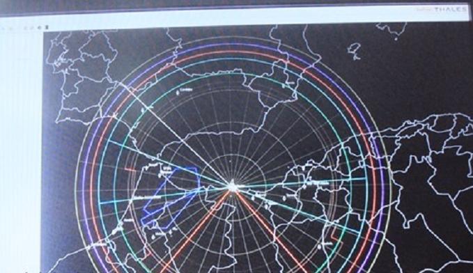
This is an actual screen image from the Thales Raytheon GM400 at Kuantan during an intercept of a suspect aircraft. IGARI is within the screen coverage in this image:


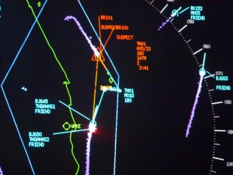
The more observant amongst you may even notice the real GM400 screen looks nothing like the image presented at the Lido Hotel.
 
I have undertaken research into the radar systems deployed by the RMAF and identified different radar systems to that quoted in your post. Can you cite sources for the Ground Master 400 deployment in the Butterworth based squadron that is part of "MADGE" RADOC #1
 
I have undertaken research into the radar systems deployed by the RMAF and identified different radar systems to that quoted in your post. Can you cite sources for the Ground Master 400 deployment in the Butterworth based squadron that is part of "MADGE" RADOC #1

If you have something to share please go ahead....
 
Here are some images of Malaysian civilian SSR radar systems based on the Selex range of products:


...and from their ATON-S training system for SSR radar:


compared with the Lido Hotel image:


Which suggests the "evidence" for MH370's flight west appears based upon a doctored image from an SSR radar.

Another image from a Thales Raytheon GM400 radar screen:


Which is interesting to compare with this statement by JACC Chairman Angus Houston:

http://www.malaysia-chronicle.com/i...d-not-do-kamikaze-dive&Itemid=2#axzz36eNRjlg3
 
this is very interesting to say the least, however I don't find that flight path suspicious because it was the only possible solution to get around indonesian airspace and not provoke their response, I don't think they would have to make this up, maybe they just edited the picture and changed a few details for some reason

the plane certainly went very low across Malaysia so it wasn't detected by their radars(or didn't leave enough trail to be recognized), there are several witnesses to that
 
I don't think it's possible to say that the image displayed at the Beijing Lido Hotel is 'doctored' but it doesn't seem to be a direct representation of a radar 'scope'. It simply depicts the times at which a radar target was recorded and overlays the target on an airways maps for context.

It would be very helpful for all interested if there was more context available from that meeting, I haven't found any but searching across languages and .cn resources is difficult.

Malaysia has declared 'secrecy' over their military radar capabilities, a contention I believe to be naive in the circumstances and I drafted the referenced paper to show that much of the relevant information regarding the location and capability of their air defense surveillance capability is readily available on the web for anyone sufficiently motivated to look.

See http://bit.ly/TUDM_ADS

I also now have similar information detailing the Thai and Indonesian air defense surveillance resources and will update the paper to detail those. Whatever direction 9M-MRO deviated over the Gulf of Thailand, it should have been detected on military air defense surveillance systems.
 
that would be nice to see, also straight line from IGARI to Butterworth is just a widely regarded assumption, I'm convinced the plane went around thai FIR as it would take only couple of minutes more to evade them

also we have statements from both thai&indonesian officials who claim the flight has never enterd their airspace

http://indianexpress.com/article/world/asia/missing-malaysian-plane-mh-370-never-entered-thai-airspace

http://www.thejakartapost.com/news/...ts-mh370-did-not-fly-indonesian-airspace.html

I doubt they would lie since there is a possibility someone else could see that and it's simply not their problem.

I have took the screenshot from your analysis and labeled with black line the border of indonesian FIR, I think the intention to get around is quite clear.

http://www.dodaj.rs/f/2M/9W/2GLcQ902/mh370fir.jpg

+ we have this

http://www.baliluxuryprivatevillas....h370_never_crossed_the_indonesian_region.html

"In addition, Indonesia and Malaysia, he added, have coordination for air defense. When MH370 declared missing, officer of the watch Malaysia have coordinated with the officer of the watch in Indonesia. "When the incident happened, officer of the watch from Malaysia asked us if we monitored suspicious objects. We have already said that we did not catch any object," said Hadi."

If we take Kate the sailoress sighting as reliable that would corroborate the low-level flying around Indonesia theory. She said she saw aircraft flying low and glowing orange (the aircraft is partly colored orange).

what I totally don't get is why they allowed for international search to last for days in south china sea if, it seems, they already had the information the aircraft has crossed back into Malacca Strait?
 
Last edited:
that would be nice to see, also straight line from IGARI to Butterworth is just a widely regarded assumption, I'm convinced the plane went around thai FIR as it would take only couple of minutes more to evade them
also we have statements from both thai&indonesian officials who claim the flight has never enterd their airspace
I understand this suggestion that they never entered Indonesia's airspace, but honestly wouldn't their military radar still have been able to see the plane. US airspace extends out beyond our shores for 12 nautical miles, and in florida I think it goes beyond that to 24nm, but the US military radar can detect objects well over the horizon for hundreds of miles. So isn't it likely that Indonesia still saw the plane on its radar regardless if MH370 entered their airspace.
 
I'm not sure if Indonesia saw it or not because I don't know their radar capabilities and what was their readiness that night when international airspace is in question, but I'm quite certain they were ready enough to detect it in their own FIR.
 
From the site you posted above, you can see how the Malaysian air defense radar overlaps and they can even see what's happening in Indonesian Airspace, so I don't understand why Indonesia's air defense wouldn't have been able to see what was happening in the Strait of Malacca, and all around its norther and western
borders.
borders.
 
being able to see doesn't mean they have seen it, also those circles are valid for planes flying at cruising altitude, not low over the surface
 
All the RMAF sites are sited on high ground, as are the Thai (RTAF) and Indonesian (TNI-AU) assets. The ranges I've indicated are conservative at 220nm, 250nm range is realistic.
 
All the RMAF sites are sited on high ground, as are the Thai (RTAF) and Indonesian (TNI-AU) assets. The ranges I've indicated are conservative at 220nm, 250nm range is realistic.
So are we to believe that countries surrounded by water have no way have using their radar to see low flying incoming traffic. I honestly have a hard time believing that... it would be foolish to not have the ability to see low flying traffic or even ocean vessels
 
The point of my paper is to present the available information and challenge the official position that no sighting, or merely "a glimpse", was made using these expensive assets.

The Thai systems are export derivatives of those used by the US for airspace surveillance around its borders; the Indonesian systems are Thales-Raytheon 2215D & 2215R units that received upgrades in 2006 or 2008.
 
So are we to believe that countries surrounded by water have no way have using their radar to see low flying incoming traffic. I honestly have a hard time believing that... it would be foolish to not have the ability to see low flying traffic or even ocean vessels

They most probably see low flying traffic, just not far from their sea territory as that would be of no use.
 
Back to the original poster, Simon Gunson: I asked if you can cite your sources that RMAF/TUDM has taken delivery of 3 Thales Ground Master 400s deployed at the sites you quoted. I'm interested to know, to ensure the information I have is up-to-date.

Also, I've been looking at the antenna scan azimuth ranges that might be possible from each location. While most of the Thai, Indonesian and Mlsian sites are sited on high ground some have nearby high ground that would cause direct obstruction or heavy backscatter at certain antenna azimuths. The Thai unit at Phuket has high ground to its south which roughly lines up with the loss of track between Pelau Perak and waypoint VAMPI as shown in the Beijing image. I now suspect that the track illustrated in Beijing was derived from the Thai assets, not Mlsia's.

http://durianasean.com/mh370-air-force-probes-napping-servicemen/

Unfortunately Don, the three MADGE sites using Thales Raytheon GM400 radar were all the subject of a probe in March 2014 investigating why teams manning them were asleep.


KUALA LUMPUR (March 19): An internal probe has been initiated by the Royal Malaysian Air Force over its glaring failure to detect Malaysian Airlines MH370 that flew over Peninsular Malaysia without raising any alarm bells.

Although Defence Minister Datuk Seri Hishammuddin Hussein had said that all standard operating procedures have been followed, it is learned that the top brass in the air wing are unhappy over the incident and a probe had been initiated.

It is learned that the crew from the three military radar bases responsible for the airspace over northern Malaysia are being questioned and investigators are looking at elements of negligence.

The radar bases are located in Butterworth, Penang; Gong Kedak, Terengganu; and Bukit Ibam in Pahang.

The radar stations are usually manned by crews of up to five men, including an officer.

Crew rotated to prevent fatigue

“The crew are rotated every two hours so that fatigue does wear them down and to prevent any miscalculations,” said a source.

The military radar bases are also linked to the Department of Civil Aviation radars.

According to sources familiar with radar operations, the military radar crew will immediately identify any commercial plane that takes off from the commercial airports and it will be tagged.

“This is so that they will be able to differentiate between civilian aircraft and other unidentified aircraft.”

It is learned that at the time of the incident, the skies over Malaysia was crowded and this could have had a hand in why the jetliner flew over Malaysia for about 30 minutes without anyone noticing it.

Malaysia military radar coverage is divided into four sectors, two each for Peninsular and East Malaysia.

‘Hostile’ response to explanation

It has 100 per cent coverage of Peninsular Malaysia.

Explanations by the authorities that the aircraft did not behave in a hostile manner, hence the lack of response has met with much disapproval from many Malaysians.

The GM 400 radar has long-range surveillance capabilities that can track a plane up to 400km away, which is more than sufficient to detect the MH370.

The radar crew could have tried making radio contact with the plane, failing which they should have alerted the air defence high command located at the Defence Ministry in Kuala Lumpur.

A decision could have been taken to scramble fighter jets to visually identify the plane, make contact with it and finally guide it to a safe landing.

The air force has stationed Sukhoi 30s in Gong Kedak and F/A-18s in Butterworth for this purpose but none saw action on March 8.

The failure to follow any of these led MH370 to keep on flying and by the time the air force realised it, it was too late.

However with supposed terrain masking and spoofing coming into the picture, the possibility of the radar system being outsmarted is looking more likely.

In 1987, amateur German pilot Mathias Rust embarrassed the Soviet military by landing his light plane in Moscow’s Red Square, defeating the world’s most complex air defence systems.
source : V Shankar Ganesh , Fz.com
Content from External Source
 
All the RMAF sites are sited on high ground, as are the Thai (RTAF) and Indonesian (TNI-AU) assets. The ranges I've indicated are conservative at 220nm, 250nm range is realistic.

Interesting to note that MH370 went off civil radar at IGARI which is 230nm from SSR radar at Genting Highlands near Kuala Lumpur. The published maximum range for the Genting Highlands radar also happens to be 230nm.

Hishamuddin Hussein commented about MH370 dropping below 5,000ft & being thrown around like a fighter jet to avoid radar, thus a tacit admission that no radar nearer than Genting highlands saw MH370, notwithstanding the RMAF facility at Kota Bharu is just 67nm from IGARI.
 
What is truly astonishing is that satellite data disproves MH370 detoured through the Straits of Malacca. Something which Malaysia has preferred not to mention.

93e3faa0a428ac3cd30912a92b47df11.jpg

Malaysia published this looped flight track for MH370 relatives at the Lido Hotel on 21 March 2014 , but later the DG civil Aviation Azharrudin at a press conference stated the images shown at Beijing were prepared by Russian PR agency Ketchum and were not intended for widespread publication as they were "untrue".

ed6df7f67e1a0b0aac0d76256ffea113.jpg
 
being able to see doesn't mean they have seen it, also those circles are valid for planes flying at cruising altitude, not low over the surface

Except that in the March 2015 Interim Report (more lies) it is claimed therein that MH370 was seen by RMAF radar at Kota Bharu crossing Malaysia at an astonishing speed of 594kt which is physically impossible for a Boeing 777 flying at low level, yet Thai radar at Hat Yai did not see any such flight.

Perhaps Guarded Don could explain how Hat Yai would miss this spectacle?
 
Simon, have you got anything to back up these assertions?

a1179102fe307c6c79860729a21a6d43.png


Not sure specifically what you were asking for?
Let me know?

Furthermore Vietnamese SSR radar at Ca Mau airport & the ADS-B receiver at Con Son Island detected MH370's transponder from 17:11 UTC until 17:30 UTC. MH370 was lost off Vietnamese radar after passing BITOD.

4f05cbeb36a5736f23864ba70a003025.jpg
 
Simon do you realise that USA&neighbour countries would quickly realise the conspiracy of Malaysians? Or you suggest it's the conspiracy of many countries including USA? While I don't trust government(completely) either, I find this hard to believe. Little to gain, much to lose.
 
Simon do you realise that USA&neighbour countries would quickly realise the conspiracy of Malaysians? Or you suggest it's the conspiracy of many countries including USA? While I don't trust government(completely) either, I find this hard to believe. Little to gain, much to lose.

Too little to gain?
You don't consider evading civil liability for exemplary damages from 239 families something to gain?

Boeing are part of Malaysia's JIT committee & have financial incentive to muddy the waters if there is any prospect MH370's loss was due to a design flaw. It is the United States NSA which refused a Freedom of Information Act request citing Executive Order 13526. On March 8th a Taiwan newspaper published a report that the USN detected a distress call from MH370 saying that their cabin "faced disintegration"

If you are not aware by now that Malaysia has said conflicting things about every aspect of the flight prior to 18:25 UTC then you have not been following the news.

We were told MH370 was seen on military radar climbing to 45,000ft, then diving West beneath 5,000ft to avoid radar where it was "thrown around like a fighter" Now since the interim report of March 2015 we have been given a new narrative that it was seen on radar transiting across Malaysia at speeds up to 594kt, a speed you can't perform in an aircraft with a VMO of 330kt at sea level. It is self evident Malaysia is deceiving the world about MH370.

If you find it too hard to believe then just confine yourself to this. Malaysia said pilots switched off the transponder at IGARI and turned west.

Vietnam who had no reason to lie or hide anything said no, they saw MH370's transponder at BITOD further north until 17:30 UTC

I would expect you to at least acknowledge there is a conflict in the official narrative.
 
this is very interesting to say the least, however I don't find that flight path suspicious because it was the only possible solution to get around indonesian airspace and not provoke their response, I don't think they would have to make this up, maybe they just edited the picture and changed a few details for some reason

the plane certainly went very low across Malaysia so it wasn't detected by their radars(or didn't leave enough trail to be recognized), there are several witnesses to that

You do realise don't you Steven that to fly low in a Boeing 777 means a maximum speed of 330kt around sea level and about 350knots at 5,000ft?

That means it could not perform the speeds claimed by alleged radar sightings.
 
Page 11 of the March 2015 report "Factual Information" asserts a target was tracked towards Penang at 594kts possibly 694kts but the type is hard to be sure.

Since that plot was created from primary radar returns, the speeds indicated would have been calculated velocity vectors and represent the aircraft's ground speed as there would be no way to separate out the wind component from the vector. The highest documented ground speed for a B772 is 735 knots. There is no reason to believe that that isn't a B777.

You do realise don't you Steven that to fly low in a Boeing 777 means a maximum speed of 330kt around sea level and about 350knots at 5,000ft?

That means it could not perform the speeds claimed by alleged radar sightings.

Where does it say that the aircraft was at 5,000 feet at that point? The plots (or factual report) do not include any altitude information for that period.
 
What is truly astonishing is that satellite data disproves MH370 detoured through the Straits of Malacca. Something which Malaysia has preferred not to mention.

93e3faa0a428ac3cd30912a92b47df11.jpg

Your understanding of what the difference in the signal path distance means is incorrect. A 275nm difference in the signal path does not translate into a literal 275nm distance on the face of the earth. Instead it creates a new circle of equidistant positions on the face of the earth. These are all of the possible points where the aircraft could be when it is that far away from the satellite.

With the bias value determined from the ground measurements, the in-flight measurements were processed to determine the satellite to aircraft distance at each measurement point. The locus of points on the earth of constant distance to the satellite is a ring (for a spherical earth these would be circles) centred on the sub-satellite point.
source: http://journals.cambridge.org/nav/mh370

sat.png
source: https://www.atsb.gov.au/media/5668327/ae2014054_mh370__search_areas_30jul2015.pdf

The ring calculated at 18:25 puts it very close to where MEKAR would be.

sat2.png

source: https://www.atsb.gov.au/media/5668327/ae2014054_mh370__search_areas_30jul2015.pdf
 
I would expect you to at least acknowledge there is a conflict in the official narrative.

there is a huge conflict and they have lied a LOT about this, but I just can't grasp how they could pull something like this without noone noticing, I think China would realise that easily and be very mad at them
 
Back
Top