Hurricane Lane Heading Towards Hawaii

Mick West

Administrator
Staff member
Metabunk 2018-08-23 12-29-41.jpg

Source:

https://www.cnn.com/2018/08/23/us/hurricane-lane-hawaii-wxc/index.html
External Quote:

Hurricane Lane's outer bands have been pummeling parts of Hawaii's Big Island with rain Thursday morning, triggering landslides and threatening serious flooding as the Category 4cyclone moves perilously close to the Aloha State.

The center of the storm -- which could become the first major cyclone to make landfall in the state in 26 years -- is expected to move very close to the main islands or cross land Thursday through Friday, the Central Pacific Hurricane Center said.
It could be so devastating that Hawaii Gov. David Inge has urged residents to set aside two weeks' worth of food and water.
"Hawaii is going to be impacted by Hurricane Lane. The question is, how bad?" Federal Emergency Management Agency Administrator Brock Long told reporters Thursday.
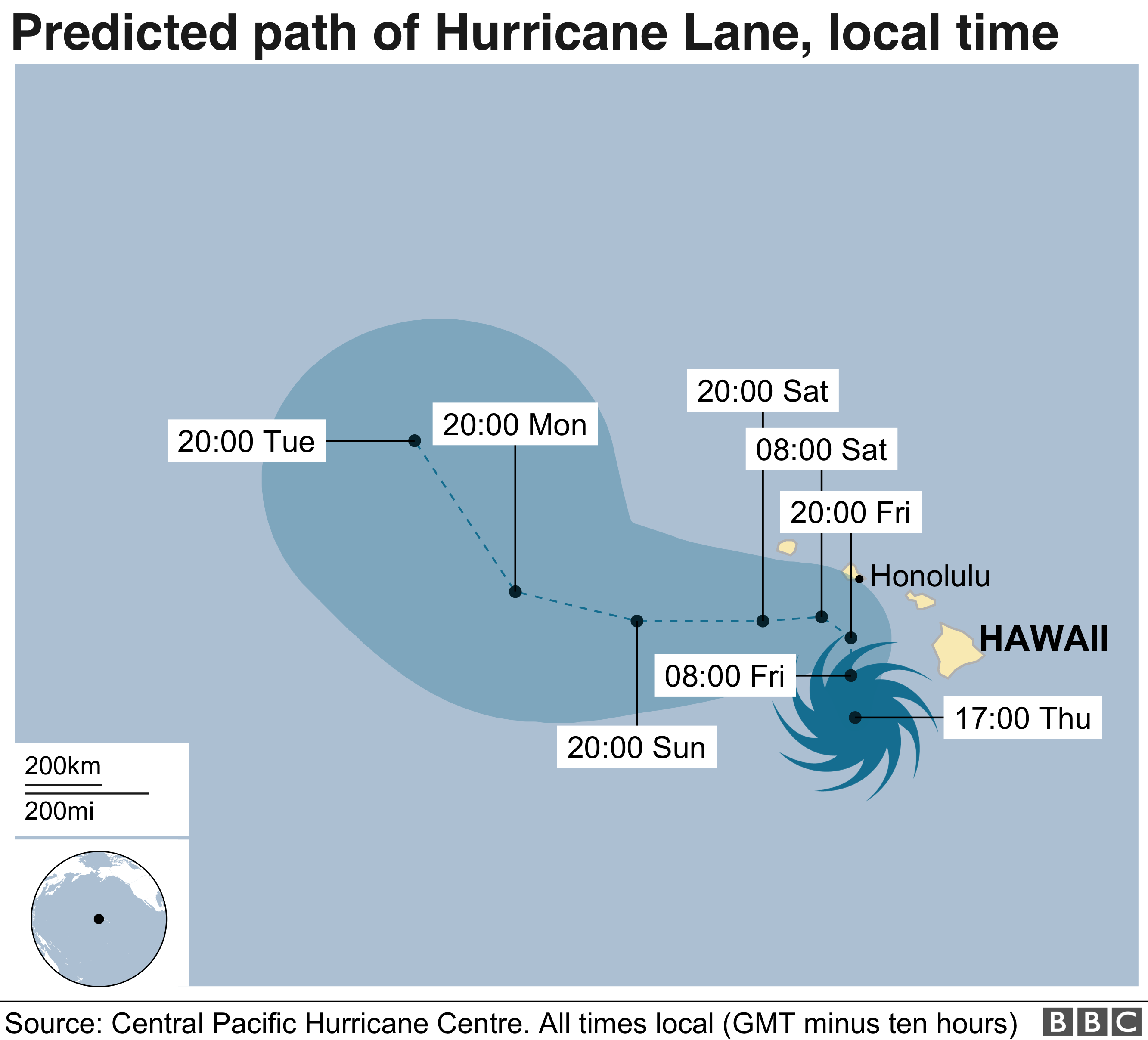
I'd expect this one, as the first significant event of the season, to be the subject of conspiracy speculation. The current forecast has it making a sharp left turn just before it hits Honolulu (which, in a bit of conspiracy geek dot connecting, in the site of Pearl Harbor). However the tracks is still a bit uncertain, and landfall is possible.

Why the left turn? It the prevailing winds in the north.
Metabunk 2018-08-23 12-34-11.jpg
 
Why a conspiracy Mick? Please explain. Surely a natural weather pattern.
Yes, but there will be conspiracy speculation. People will suggest that the movement of the hurricane is suspicious, possibly that it has been engineered to distract from Trump's problems, or that it's a consequence of covert geoengineering.

For example:

Source: https://www.youtube.com/watch?v=appgMimAeBI

External Quote:
The Military industrial complex is fully engaged in controlling the weather and they are causing this major hurricane to impact the Hawaiian islands directly. If they have the ability to steer these deadly weather events why don't they use this technology to steer it away thus saving lives and property? Think about Katrina.
That's just what happens with large weather events now. Part of the reason for threads like this is to keep an eye on what actually happens so what false claims can be debunked later.
 
External Quote:
The Military industrial complex is fully engaged in controlling the weather and they are causing this major hurricane to impact the Hawaiian islands directly. If they have the ability to steer these deadly weather events why don't they use this technology to steer it away thus saving lives and property?

so... if it hits Hawaii, it's a conspiracy to destroy Hawaii. and if it moves to the side, its proof they are directing it? Nothing like covering all your bases.

People will suggest that the movement of the hurricane is suspicious,

I remember Kyle moved erratically, and when looking his map up I see such movements are not that uncommon.

kyle_bret.png


lili_untitled.png


september_3_curly_c.png
 
Last edited:
Mick, not related to conspiracy - but what effect, if any, will a major storm like this have on the lava flow? Will it have any noticeable effect, or is the lava flow just too powerful to stop?
 
Mick, not related to conspiracy - but what effect, if any, will a major storm like this have on the lava flow? Will it have any noticeable effect, or is the lava flow just too powerful to stop?
It's not going to do anything to the lave flow as falling rain, but rising rivers could make a difference. It rains all the time in Hawaii though. The winds might blow ash and volcanic smog around.
 
Hawaii is situated well within tropical storm and hurricane territory, so the occasional Hurricane should not be discounted. It does though normally get a level of protection from high pressure to the North during the summer period, steering low pressure safely around to the North West and away from the islands. The Aleutian High pressure ridge on this occasion is further North, allowing low pressure to dominate. This in turn is why the hurricane is now tracking North-West across the islands, bringing Honolulu into the picture. North-west will be it's natural course considering the position of the high pressure to the North.

4a45140c98de0db877e13bc279144d07.png


The only argument for geo-engineering is that it forcibly moved a massive ridge of high pressure, the size of a continent further north, which indeed would be an incredible feat of engineering.
 
Here's another:


His main point seems to be that the wind speeds are exaggerated. And maybe something to do with chemtrails (I didn't watch the whole thing).

(Poster is a Nibiruist who believes "The End is Nigh.")
 
Last edited:
It's Obama's fault.


Source: https://twitter.com/JohnKerry/status/1033163772310040576


External Quote:
OWEN SHROYER (HOST): Call me crazy, call me a conspiracy theorist, I'm going to show you right now from August 9 an energy wave or whatever you want to call it being fired out of Antarctica, split two hurricanes that were forming in the Pacific Ocean about to hit Hawaii. Guys, go ahead and roll that b-roll.
External Quote:

PROF. DARRELL HAMAMOTO: Owen, that's an amazing graphic. I think we've seen a number of the channels on YouTube that show us a different bizarre weather that's been occurring across the world and in the United States that are listed in YouTube. But in watching that graphic, I'm remembering all of a sudden that didn't John "Skull and Bones" Kerry, the former presidential candidate against George W. Bush, another Skull and Bonesman, didn't he go -- he made a quick trip to Antarctica not too long ago, did he not?

SHROYER: No, you're 100 percent accurate. John Kerry was in Antarctica, I think it was two years ago or less.
https://www.mediamatters.org/video/...o-energy-beam-shot-antarctica-possibly/221094

The beam they are discussing is a stitching artifact on the MIMIC TPW morphed composite imagery from August 9.
http://tropic.ssec.wisc.edu/real-time/mimic-tpw/global/anim/20180805T000000anim72.gif
 
View attachment 34203
Source:

https://www.cnn.com/2018/08/23/us/hurricane-lane-hawaii-wxc/index.html
External Quote:

Hurricane Lane's outer bands have been pummeling parts of Hawaii's Big Island with rain Thursday morning, triggering landslides and threatening serious flooding as the Category 4cyclone moves perilously close to the Aloha State.

The center of the storm -- which could become the first major cyclone to make landfall in the state in 26 years -- is expected to move very close to the main islands or cross land Thursday through Friday, the Central Pacific Hurricane Center said.
It could be so devastating that Hawaii Gov. David Inge has urged residents to set aside two weeks' worth of food and water.
"Hawaii is going to be impacted by Hurricane Lane. The question is, how bad?" Federal Emergency Management Agency Administrator Brock Long told reporters Thursday.
I'd expect this one, as the first significant event of the season, to be the subject of conspiracy speculation. The current forecast has it making a sharp left turn just before it hits Honolulu (which, in a bit of conspiracy geek dot connecting, in the site of Pearl Harbor). However the tracks is still a bit uncertain, and landfall is possible.

Why the left turn? It the prevailing winds in the north.
View attachment 34204
Up until now I didn't realize hurricanes existed on the west coast.
 
Up until now I didn't realize hurricanes existed on the west coast.
There's lots of them, they just normally fizzle out before they get close to land because of the cold water.
https://en.wikipedia.org/wiki/List_of_California_hurricanes
External Quote:

There are two reasons why tropical cyclones rarely strike California: sea surface temperatures, and the usual upper level steering winds in the eastern Pacific, with sea surface temperatures being more important.

Tropical cyclones usually require very warm water to depth, generally above 26.5 °C (80 °F) extending to a depth of 50 meters (160 ft).[1] However, the waters off California are cold even in summer. They rarely rise above 24 °C (75 °F) in near-shore southern California,[2]and usually remain below 17 °C (63 °F) along most of the rest of the coast and outer coastal waters, although El Niño events may warm the waters somewhat. This is due primarily to the extensive upwelling of colder sub-surface waters caused by the prevailing northwesterly winds acting through the Ekman Effect. The winds drive surface water to the right of the wind flow, that is offshore, which draws water up from below to replace it. The upwelling further cools the already cool California Current which runs north to south along coastal California and even much of coastal Baja California. This is the same mechanism which produces coastal California's characteristic fog.

The second reason is the general path of tropical cyclones in the eastern Pacific. They generally move north-westward or westward due to steering by the prevailing upper level winds, which takes them far out to sea and away from land.[2]
I new cyclones existed, but I thought hurricanes only existed on the east coast because of the direction of spin.
 
Back
Top