• MH370 speculation has become excessive recently. Metabunk is not a forum for creating theories by speculation. It's a forum for examining claims, and seeing if they hold up. Please respect this and keep threads on-topic. There are many other forums where speculation is welcome.

Flight MH370 Speculation

Status
Not open for further replies.


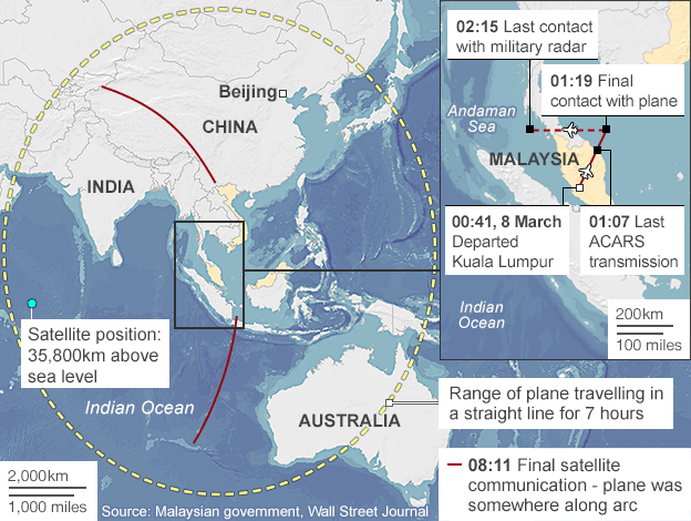
Now if Malaysian Military last saw the plane at 2:15am, why weren't there alarm bells going off within their military infrastructure when they picked up an unknown airplane flying through their airspace unannounced and without a transponder. Another question I have is why they didn't discover this sooner, right? I think this data came out a few days to 4 days after the plane went missing. Is it that easy to fly a plane over a country's airspace without raising the alarm? Did they miss this event, or did they respond by sending up jets or asking one of their allies to investigate this? I know the US has a forward operating base about 2000 miles from Malaysia in Diego Garcia, is it likely they could've had naval ships in the area monitoring the skies
 
Shouldn't there have been military Navy ships in the Indian Ocean and China Sea at this time. Aren't these waters constantly being monitored by military of all nations capable of doing so. I read somewhere that land based radar can only see out to sea about 150 miles or so, and then its up to high frequency radio to communicate with the airplanes. But that got me to thinking. Most Navy's in the world would like to see what happening beyond this point, so they would generally place ships capable of using radar to track whats in the air. Especially in this region of the world, south of China, west of Australia, Indonesia, etc, etc, etc....

Seems vanishingly unlikely. The ocean is very large, and you can't practically cover all of it with floating radar.
 
Seems vanishingly unlikely. The ocean is very large, and you can't practically cover all of it with floating radar.
I totally agree Mick, but the waters that I'm concerned with are off the coast of all the near by countries. These waters would certainly be monitored, wouldn't they. I'm not talking about 1000's of miles off the coast, but its probably a good bet to "assume" the waters between Australia and Indonesia are monitored, and west of Australia out to a certain distance and south of the chain of islands. Its a huge commercial shipping highway, which warrants the protection of Naval ships at times... Just a thought.
 
Can a mobile phone be tracked using GPS even if the phone doesn't have communication with a cell tower? Is it possible for a family member to have used "where's my iPhone" during the flight to track them? Has anyone ever tried doing this?
 
Can a mobile phone be tracked using GPS even if the phone doesn't have communication with a cell tower?
Not that I'm aware of. GPS systems (like in phones, cars etc) receive transmissions only, then use that data to calculate it's position.

Some more detail about Inmarsat, the services they provide and how they came to their conclusion. http://www.theguardian.com/world/2014/mar/24/flight-mh370-inmarsat-aaib-analysis


If the plane has its own "picocell" essentially a tiny mobile phone tower set up inside the plane then that can be linked to the satellite communications system and enable passengers to use their own mobile phones to make calls, which are routed through the satellite and back to earth.
Content from External Source
I had an inkling this ^^^ was more than possible. I remember now, even ferries offer cell-phone services as they sail beyond tower range.
 
I totally agree Mick, but the waters that I'm concerned with are off the coast of all the near by countries. These waters would certainly be monitored, wouldn't they. I'm not talking about 1000's of miles off the coast, but its probably a good bet to "assume" the waters between Australia and Indonesia are monitored, and west of Australia out to a certain distance and south of the chain of islands. Its a huge commercial shipping highway, which warrants the protection of Naval ships at times... Just a thought.

I doubt it. Land based radar gives enough coverage. Ships might feed their radar data to some central database, but it's going to be variable, and certainly not 100%.
 
Can a mobile phone be tracked using GPS even if the phone doesn't have communication with a cell tower? Is it possible for a family member to have used "where's my iPhone" during the flight to track them? Has anyone ever tried doing this?

Not that I'm aware of. GPS systems (like in phones, cars etc) receive transmissions only, then use that data to calculate it's position.

Correct. If your phone is not in communication with a cell tower, it's not in communication with anything. Your phone is (in part) a GPS receiver. The "find my iPhone" relies on the phone sending its location to Apple over a cellular (or WiFi internet) data connection.
 
Latest from the news conference, reported by CNN @1729 EDT today:

http://www.cnn.com/2014/03/24/world/asia/malaysia-airlines-plane

A grim-faced Malaysian Prime Minister confirmed the worst fears of the families of those aboard Flight 370, announcing Monday that the missing plane went down in the southern Indian Ocean.
Content from External Source
So any story besides that would be wild speculation. Until they find the wreckage, and the black boxes we will never know what happened on that flight, will we?
 
Not that I'm aware of. GPS systems (like in phones, cars etc) receive transmissions only, then use that data to calculate it's position.

Some more detail about Inmarsat, the services they provide and how they came to their conclusion. http://www.theguardian.com/world/2014/mar/24/flight-mh370-inmarsat-aaib-analysis


If the plane has its own "picocell" essentially a tiny mobile phone tower set up inside the plane then that can be linked to the satellite communications system and enable passengers to use their own mobile phones to make calls, which are routed through the satellite and back to earth.
Content from External Source
I had an inkling this ^^^ was more than possible. I remember now, even ferries offer cell-phone services as they sail beyond tower range.
Did this plane have a "picocell", and if so would that have been communicating with satellites or cell towers?
 
Correct. If your phone is not in communication with a cell tower, it's not in communication with anything. Your phone is (in part) a GPS receiver. The "find my iPhone" relies on the phone sending its location to Apple over a cellular (or WiFi internet) data connection.
https://discussions.apple.com/thread/4288839?tstart=0
Actually Mick, Iphone 5's have a GPS receiver in them. I got this off the Apple forum
As rominggnome showed, the iPhone does have a GPS receiver, and has since the iPhone 3G. And as Rudegar pointed out, the iPhone also has A-GPS capability, which lets the GPS receiver determine its current location much faster than normal. Without A-GPS, the GPS receiver has to wait -- sometimes multiple minutes -- before it can determine its location, because it doesn't know where the satellites are. A-GPS allows the phone to download satellite almanac data over the cellular network, so the GPS receiver can immediately know where all the satellites are. A-GPS is not necessary, however, for GPS operation -- even if you have no cellular service, you can still use the GPS receiver in the iPhone. I have done this many times, so I have no idea why your friends have had trouble. I recommend the MotionX GPS app, and it works really well out in the woods. You can even download offline map data.

But what the iPhone does NOT have is WAAS capability. The GPS receiver works by measuring how long it takes for the radio signals to propagate between the satellites and the receiver. The propagation time varies based on the current density of the atmosphere between each satellite and the receiver. Because of the density flucuations, a standard GPS receiver can only get a fix that is accurate to about 10 meters. However, some geostationary satellites transmit atmospheric density information that lets GPS receivers compensate for current atmospheric conditions, and this enables accuracies in the neighborhood of about 1 meter. Garmin has had WAAS capable receivers for years, as have other hand-held and aviation-based GPS receivers, so it is a bit surprising that Apple has not incorporated WAAS into their GPS radio -- especially since WAAS density data can be downloaded via the Internet, eliminating the need for increased radio weight. I and others have submitted requests for a WAAS capable GPS receiver in the iPhone, but Apple has not delivered. Perhaps it is because WAAS is only available in North America. However, according to the specs for the iPhone 4S and 5, it now supports GLONASS, which provides near-WAAS accuracy when combined with standard GPS, and is available worldwide. At least that is the next best thing to WAAS.

Now, the CoreLocation service on the iPhone combines 3 completely separate technologies: GPS, cell tower triangulation, and Wifi-based location. I don't know the algorithm they use, but I presume that they use whatever service is currently providing the most accurate location information.

Note that cell tower triangulation has nothing to do with GPS.
Content from External Source
http://www.everymac.com/systems/app...d-gps-how-gps-works-real-time-navigation.html
iPhone GPS Support

The iPhone 3G and all subsequently released iPhone models use A-GPS -- or "Assisted GPS" -- which in basic terms accesses an intermediary server when it is not possible to connect directly via satellite -- indoors, for example -- and this server provides the nearest satellite with additional information to make it possible to more accurately determine a users position
Content from External Source
So it is possible for the iphone 3G and later to communicate with GPS satellites directly, and they will also use all 3 methods to triangulate your position if you are indoors.
 
https://discussions.apple.com/thread/4288839?tstart=0
Actually Mick, Iphone 5's have a GPS receiver in them. I got this off the Apple forum
.... So it is possible for the iphone 3G and later to communicate with GPS satellites directly, and they will also use all 3 methods to triangulate your position if you are indoors.

Well yes, I just said your phone is a GPS receiver. It receives signals from the GPS satellite. It does not communicate with the satellite. i.e it does not transmit to the satellite. Likely all the phones on the plane were quite capable of determining their positions to within 100 feet. But that does nobody any good if they can't actually communicate.

GPS is one way. The satellites send, and the GPS receiver in your phone receives it. The satellites do not receive anything at all from the phone.
 
Well yes, I just said your phone is a GPS receiver. It receives signals from the GPS satellite. It does not communicate with the satellite. i.e it does not transmit to the satellite. Likely all the phones on the plane were quite capable of determining their positions to within 100 feet. But that does nobody any good if they can't actually communicate.
GPS is one way. The satellites send, and the GPS receiver in your phone receives it. The satellites do not receive anything at all from the phone.
Oh, so what your saying is if the people on the plane wanted to locate their phone, they would've been able to do so within 100 feet because its one way, but for someone else to do the "locate my iPhone" it wouldn't work for them, it would only work for the person holding the actual phone. So when they say this;
A-GPS is not necessary, however, for GPS operation -- even if you have no cellular service, you can still use the GPS receiver in the iPhone. I have done this many times, so I have no idea why your friends have had trouble.
it's limited to the one holding the phone so they can find their position. Right? If one of their friends were standing next to them and tried to locate their friend's phone it wouldn't work is what your saying.
 
Oh, so what your saying is if the people on the plane wanted to locate their phone, they would've been able to do so within 100 feet because its one way, but for someone else to do the "locate my iPhone" it wouldn't work for them, it would only work for the person holding the actual phone. So when they say this;
it's limited to the one holding the phone so they can find their position. Right? If one of their friends were standing next to them and tried to locate their friend's phone it wouldn't work is what your saying.

Right - the "find my iPhone" is not actually tracking the phone in the way a radar tracks a plane. It's just telling you where the phone last told Apple that it thought it was (which it usually figures out by listening to GPS satellites, but can also do by WiFi and cell tower triangulation). The phone will only send this info if it has a data connection, which is entirely separate to the GPS receiver.

It's a common misconception the GPS satellites track the position of things like phones. They don't, they just act like beacons, sending out a synchronized set of broadcasts, and the phones themselves track where they are by triangulation from the time the signals arrive.
 
Last edited:
I'm sure these experts know what they're talking about but does anyone else think this is questionable?

Since then Inmarsat have worked with more data from other Malaysia Airlines flights to refine their measurements.

They also brought in Boeing and ran their calculations past other UK experts.

This left them confident enough to confirm that it could only have been travelling along the southern corridor - and that because there was nowhere for it to land on that path, it would have eventually run out of fuel and come down in the Indian Ocean.

"We don't know whether the plane stayed at a constant speed, we don't know whether its headings changed subsequently," he said.

"We applied the autopilot speeds - about 350 knots. We applied what we knew about the fuel and range of the aircraft to hit the series of ping information we had.
Content from External Source
http://news.sky.com/story/1231155/inmarsat-how-missing-flight-mh370-was-tracked
 
Actually, I think the plane was equipped with a "picocell".
Inmarsat's control room in London, like some of its other 60 locations worldwide, looks like a miniature version of Nasa: a huge screen displays the positions of its 11 geostationary satellites, and dozens of monitors control and correct their positions. A press on a key can cause the puff of a rocket on a communications satellite 22,236 miles away, nudging its orbit by a few inches this way or that.

More prosaically, Inmarsat's systems enable passengers to make calls from their seats and also to use Wi-Fi and connect to the internet while flying.

If the plane has its own "picocell" essentially a tiny mobile phone tower set up inside the plane then that can be linked to the satellite communications system and enable passengers to use their own mobile phones to make calls, which are routed through the satellite and back to earth.

After its creation, Inmarsat's maritime role rapidly expanded to providing connectivity for airlines, the media, oil and gas companies, mining and construction in remote areas, and governments.

http://www.theguardian.com/world/2014/mar/24/flight-mh370-inmarsat-aaib-analysis
Content from External Source
The 8 pings that were received via satellite were from this system I believe, and thats why Inmarsat was brought in to help find out where the missing plane went.
Something I find a bit odd, and don't entirely understand is this statement in the link I provided:
The new method "gives the approximate direction of travel, plus or minus about 100 miles, to a track line", Chris McLaughlin, senior vice-president for external affairs at Inmarsat, told Sky News. "Unfortunately this is a 1990s satellite over the Indian Ocean that is not GPS-equipped. All we believe we can do is to say that we believe it is in this general location, but we cannot give you the final few feet and inches where it landed. It's not that sort of system."
Content from External Source
What does the 1990's satellite over the Indian Ocean not being equipped with GPS have to do with anything. Does it mean if they employed a satellite with GPS on it, they could've definitively found the "exact" location of the plane at each "ping" it transmitted. More over, if thats is a distinct possibility then why wouldn't they have involved a more capable satellite with GPS on board, instead of choosing this one. I know it cost a great deal to move satellites around in space, but someone else is presumably paying the bill for that.. Right?
 
Inmarsat is a satellite communications operator. They offer a wide range of networking services to air, sea and land based systems, including airlines. It does not mean that every customer of their's will be using every service/system they offer - bit like cable/satellite TV. A betting shop would likely only buy racing channels.
 
What we know:

1. The aircraft lost all comms shortly after top of climb. No distress call was issued or received.

2. It was tracked by primary Air Defence Radars turning left and heading out over the Malacca Strait on a WNW heading. In my experience, there was probably no operator actually following it. Countries like Malaysia do not maintain a rapid response air defence posture unless they thinks it is necessary or during an exercise. The tracking was probably determined after the fact by checking the records. Thailand also tracked this aircraft, ditto the same comments about defence posture.

3. Reports of altitude changes have yet to be 100% confirmed.

4. Around 1 hour after the the WNW turn, and out of radar range, the aircraft was deliberately turned south into the Indian Ocean.

5. Its last general position fix occurred within 30 minutes of when it would have ran out of fuel.

6. It is unlikely to have been tracked much further south of Indonesia. The Australian Jindalee over the horizon radar (JORN) needs to be steered and turned on..(it isn't always). Whether or not it tracked the aircraft may never be known. Australia does not operate a string of fixed Air Defence Radars on its northwest coast.

7. Whoever flew it was unaware of the Satcom handshake protocol that allowed the general position to be known.

Anything else has yet to be released or is speculation.
 
2. It was tracked...

Anything else has yet to be released or is speculation

Would you have a link for this as I only read the Malaysian military were sure what they tracked was MH370 but did not identify it, which to me still leaves a nagging doubt.
I'm still puzzled by this whole Inmarsat business. Have they said anything about their pings matching anywhere from "All right, goodnight" to the end of this WNW detour, as I've not read about it.
 
I'm sure these experts know what they're talking about but does anyone else think this is questionable?

Since then Inmarsat have worked with more data from other Malaysia Airlines flights to refine their measurements.

They also brought in Boeing and ran their calculations past other UK experts.

This left them confident enough to confirm that it could only have been travelling along the southern corridor - and that because there was nowhere for it to land on that path, it would have eventually run out of fuel and come down in the Indian Ocean.

"We don't know whether the plane stayed at a constant speed, we don't know whether its headings changed subsequently," he said.

"We applied the autopilot speeds - about 350 knots. We applied what we knew about the fuel and range of the aircraft to hit the series of ping information we had.
Content from External Source
http://news.sky.com/story/1231155/inmarsat-how-missing-flight-mh370-was-tracked
Yes it's questionable. They received 8 pings (which isn't necessarily tracking them). They had to reposition a satellite over the Indian Ocean, Why? After the fact, and how did positioning a satellite after the fact help them identify where the plane could've been, considering they were sifting through "old" data transmissions. They were only able to calculate this was the "most likely" course based on a best estimate by using other planes that flew similar routes. By taking these other planes' "pings" and already knowing their course, they were able to deduce this southerly route was the best approximation. My only questions are, what planes actually fly that same route or near that route towards the south indian ocean for them to have felt comfortable with that approximation. How does TWACobra know the plane deliberately turned south (based on "only" if wreckage is found in the SIO) when none has been found yet, when know one knew that up until 24hrs ago.
 
How does TWACobra know the plane deliberately turned south (based on "only" if wreckage is found in the SIO) when none has been found yet, when know one knew that up until 24hrs ago.

Because I have experience on Boeing aircraft, talked to a 777 pilot and concluded that there is no way a "ghost plane" could have flown that route. It is based on knowledge of the autopilot systems and the isogonal chart of the Indian Ocean. It is all explained in that PPRUNE post, which I wrote and other pilots agree with me. You'll have to read the post, I won't replicate it here.

Put simply, if the aircraft flew to the SIO, it was done deliberately.
I tried reading it to the best of my ability, but there are way too many sophisticated acronyms for my intelligence. I got the general gist of it though. Good Read. I think the "ghost plane" theory has been out the window for some time now to be honest with you. How about what Pete mentioned above in #346, its something similar that I asked a while back. Could electronics have gone dead on the aircraft leaving the pilots to fly in the dark, so to speak. Maybe they turned back to find an airport or the one they took off from. Is that possible? Could a pilot fly one of those planes in the dark without electronics and still find a place to land that thing. Could they find their way back to the airport, or got confused up there and got lost trying to circle back. I know it happened to flight 19 off the coast of Florida some 50+ yrs ago.

Also we're assuming they flew in straight lines, who knows if the plane circled a few times between each ping. No one knows how the plane got from one ping to the next ping. No one knows how fast they were flying or at what altitude. They are "best guessing" based on "auto pilot" protocol. It's likely there could've been maneuvering during each of the pings, and lets not forget the pings only locate a "general" location within about 100 miles or so, Right?

Furthermore, whats disturbing me is if these guys wanted to hijack the plane and crash it into the ocean, why turn the plane around and fly for another 8hrs or so and risk being seen by radar or military radar. If the plane flew on for another 7-hrs thats an hour or 2 after it was supposed to land in Bejing. Why didn't they just crash the plane ASAP into the ocean.

Also, your a pilot TWCOBRA. What about the passengers. Why didn't a single call or text come from that plane during the 8hr flight? We hear alot of news about cabin pressure, is there honestly something the pilot(s) could've done with the plane to incapacitate the passengers.
 
Last edited:
TWCobra, if it was hijacked someone would've announced it. Terrorist would've jumped at the opportunity for bragging rights, as they usually do in these situations. If it was hijacked, would a pilot have enough time to put in the 911 code to the transponder without the hijacker noticing? Also who has immediate access to the transponder, do both pilot and copilot have immediate access to it, and if one or the other shut if off would anyone in the cockpit know it was turned off?
 
Also who has immediate access to the transponder, do both pilot and copilot have immediate access to it, and if one or the other shut if off would anyone in the cockpit know it was turned off?

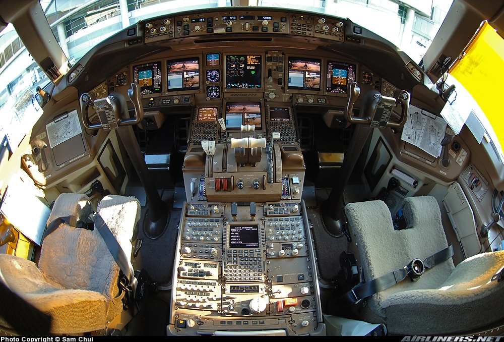
The transponder control panel is conveniently located on the center pedestal, between each pilot's seat.

Here's a pretty good overall view for orientation:


Transponder is to the right of the center CDU (the thing with the CRT screen and keypad). Above the transponder is the Audio Control panel (mic select, receiver select and volume knobs, etc).

If one guy turned it off (really, to "Standby"), it would turn off the TCAS, but it's not likely to be noticed by the other person immediately...unless they had another airplane obviously in sight, and it wasn't displaying a TCAS symbol.

( I probably should note that the photo is Copyright, owned by Sam Chui - a very interesting travel writer, and great photographer BTW - and is hosted at airliners.net. Page link: http://www.airliners.net/photo/Emir...91926/L/&sid=450e81f6b88de15699395f124c454051 )
 
Last edited:
I was just speaking to someone who was very upset that transponders could be "turned off."

I could only respond that I did not know why, but wasn't assuming that there might not be some logical
reason I was not aware of...has TW or anyone else with a lot of flight experience already offered an explanation?

p.s. The person had also heard that reaching the transponder switch was quite a lengthy, complicated task...
so Weedwacker's pic above kind of nudged me to ask
 
I was just speaking to someone who was very upset that transponders could be "turned off."
.......... The person had also heard that reaching the transponder switch was quite a lengthy, complicated task...

Simple reason is that a transponder is not used when on the ground (with some exceptions, there are airports that are starting to incorporate systems that use the transponder to help control ground traffic. This is ASDE-X https://www.faa.gov/air_traffic/technology/asde-x/). The airport that has this equipment will inform pilots in the ATIS recording when to use transponders for surface movements.

But, for decades it was considered a nuisance to ATC when the transponder was on while on the ground (say, if a pilot forgot and left it on after landing and during taxi to parking).

And no, not difficult at all to operate.
Simple solution would be to make it so the transponder turns on and stays on once the plane gets to take off speed.

I suspect there will be some kind of tracking (GPS) system implemented after this. Possibly even transmitting black box info directly to the airline and not have to rely on recovering boxes at all.
 
Simple solution would be to make it so the transponder turns on and stays on once the plane gets to take off speed.
I suspect there will be some kind of tracking (GPS) system implemented after this. Possibly even transmitting black box info directly to the airline and not have to rely on recovering boxes at all.

It still goes against my instincts not to have control. And of course, there is always a circuit breaker for both #1 and #2. Some companies might opt to wire its power through the air/ground sensing logic, but not with the ASDE-X being implemented, I suppose.

Your second idea is more likely, and some airlines already opt for certain data downlinks during flight (as was seen with Air France 447, for example). And we've covered the fact that engine manufacturers have an interest in monitoring engine conditions in real-time. At present for flight parameters recording it is still a matter of bandwidth I reckon, (the modern SSFDRs compile a LOT of data), and bandwidth is expensive.

But, technology marches on.
 
It still goes against my instincts not to have control
I agree. I still drive manual and I cant stand my new anti-lock brakes ; (

I think if the transponder stayed on automatically they would forego the blackbox downloads. its an easier fix and less expensive. But if they flew to out there locations (middle of the indian ocean) would the transponder reach that far anyway?
 
It still goes against my instincts not to have control.
You're still in control, just don't get to take off speed. :) What good reason is there to turn it off in flight?

Adding.. just make it so there is control except beyond a certain airspeed or altitude.
 
Guys, if you look way back in this thread, you'll see where I originally posted my opinion regarding what was the most likely cause of this incident. Nothing has changed that opinion and it is now almost certainly what happened. I formed this opinion within 36 hours of the aircraft going missing.

Re: turning the transponder off. A modern flight deck and the operational/security procedures surrounding it are predicated on the people flying the aircraft being of sound mind and having good intentions. Unfortunately there have been a very small number of cases of flights where this is not so.

How do you guard against it happening again with 100% certainty? You probably cannot.
obviously you cant guard against nuts. but you can probably, in this day and age, guard against 239 people on a plane or boat being unfound for 2 weeks.
 
If it can be done for trucks it can be done for airliners.
http://www.dat.com/products/tracking-and-communications.aspx
After reviewing all of the airlines earnings it amounts to an embarrassing 155 million compared to the 143.5 billion they take in. That's roughly a 1% profit margin, or better yet it works out to roughly $0.21 per passenger. An overhaul to make each plane capable of downlinking its flight data and black box data would be astronomical in cost, up front that is. The sad part is most commercial planes are already destined to have this ability, but most of the cost is in retrieving this information during flight, and storing this information somewhere until its no longer needed. But it is possible, in a day an age where the NSA can quietly record every single piece of data in the world, I'm sure its just as easy to do the same with the airline industry. I think an easier way to solve the problem, and its more cost effective, is to install GPS in every plane so its course can be tracked from destination to destination, like the commercial trucking and bussing industry already does in the US. We don't need black box data or flight recorder information to be sent wirelessly if we have GPS locators in each plane. Once the plane is found we can retrieve that information on our own after salvaging the plane. Much cheaper, and we already have the GPS satellites in orbit, so the airline industry could use them.
 
Status
Not open for further replies.
Back
Top