In the last binoc photo I was standing on grass, near stairs, 10-15 feet above water
Thanks for the further info. Please correct me on anything I post below if it's wrong. Just trying to look at the measurements for this pic -
- which you say was taken from the lawn of the house at, I think, 44.067773, -69.068766.
This gives us some actual measurements:
Elevation of lawn above mean sea level: 16 feet
Elevation of camera above lawn: ~5.5 feet
Distance to Marblehead Island: 2.56 miles
Elevation of summit of Marblehead: 33 feet amsl
Distance to Matinicus: ~16.5 miles
High point of NE portion of Matinicus (as seen to left of Marblehead): ~60 feet amsl (not including trees)
I seem to remember you also saying that the photo was taken at low tide, which you said was 9 feet below msl. This gives, with standard refraction:
Predicted amount of Marblehead hidden: None
Predicted amount of Matinicus hidden: 48.3 feet (therefore ~20 feet of high point of NE portion visible, not including trees)
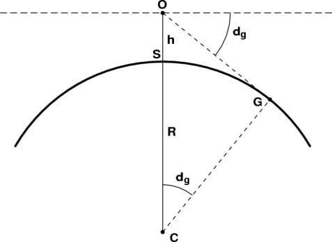
Note: when using the curvature calculator, viewer height is height above water, not height above sea level - so 30.5 feet, in this case.
Though difficult to tell just by eyeballing, it does seem that there's more of Matinicus visible than that predicted by the curvature calculator. Therefore, I suppose we can assume that this photo shows a greater effect of refraction than standard.
I also looked at what the viewing angles to the various points should be - using the technique outlined
here - and compared it to what we see in the photo:
Notes:
- Negative angles are those below "eye level", positive those above
- I used the peak and base of Marblehead as measures in the photos. I don't really find this satisfactory, and would like it if there were more points in the picture
- For both earth models, the apparent height order works out (I was wrong in this earlier)
- For the sphere earth model, the error for the apparent viewing angle to Matinicus is tiny; for the flat earth model, it's significant (16x greater)
- On the sphere earth, all the points are predicted to be below eye level, while for the flat earth model, the two summit points are predicted to be above eye level. Therefore, checking that with a theodolite (next year) could give you more information
Apologies for being late to the show: I wrote most of this much earlier, but got sidetracked with other things, so I guess there's some duplication of information.
Do please check out, though, my using ~69 feet for the high point of NE Matinicus, rather than the island summit elevation of 103 feet (which is to the right of Marblehead).
Also, having horizontally aligned the photo (at the base of Marblehead), I've noticed some significant distortion going on. Thoughts?
Oh, and - since we know the earth's a globe, seeing more of Matinicus must be down to refraction. What else could it be?
")


") There was weird weather patterns last week (at least by me) but I think you need to add at least 25-30 feet for the tree line.
There was weird weather patterns last week (at least by me) but I think you need to add at least 25-30 feet for the tree line.