
You are using an out of date browser. It may not display this or other websites correctly.
You should upgrade or use an alternative browser.
You should upgrade or use an alternative browser.
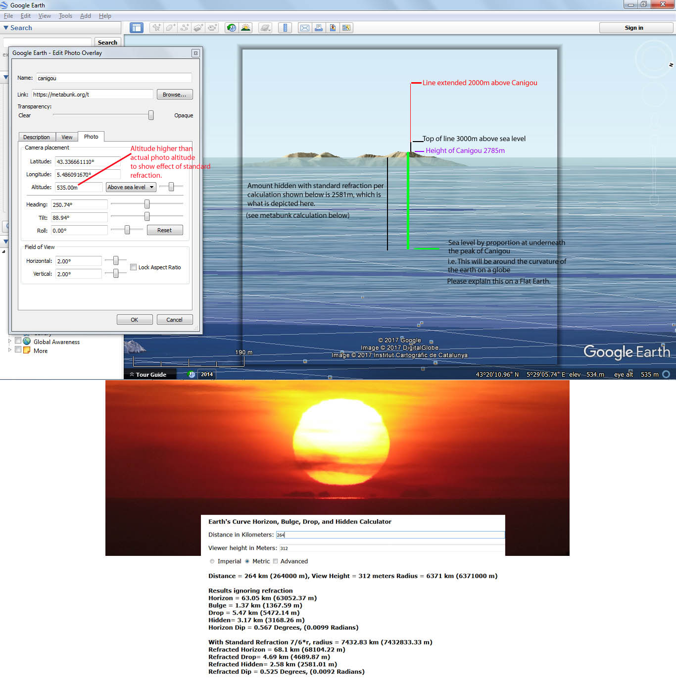
Explained: Observations of Canigou, Curvature of the Earth & Atmospheric Refraction
- Thread starter jeranism
- Start date
Because it's close to the horizon, so lots more refraction.Even at 15 miles, i should barely see tops of trees, i easily see land and all of trees.
Vanishing point also extends visibility with elevation, that doesn't really help my quandary, i took pics from higher up, yes more was visible, but nothing should be.
"Vanishing point" is a meaningless 2D abstraction for parallel lines. Just an observation, not really a useful point unless you have some known parallel lines of known position and orientation.
If you can see something, then getting higher up will mean you can see more of it, as less is behind the curve.
eenor
Member
That sounds like magical thinking to me, I've sailed those waters, visibility is clear, not refracted."Vanishing point" is a meaningless 2D abstraction for parallel lines. Just an observation, not really a useful point unless you have some known parallel lines of known position and orientation.
If you can see something, then getting higher up will mean you can see more of it, as less is behind the curve.
What's clear in your image of Matinicus?That sounds like magical thinking to me, I've sailed those waters, visibility is clear, not refracted.
Rory
Closed Account
I make Mantinicus pretty much bang on 16 miles from your stated viewing point. The elevation of the island seems to mostly range from 20-60 feet above sea level, with places up to 100 feet.
At 16 miles, you're correct, very little of Mantinicus Isle should be seen, given standard refraction - though as we all know, famously from Rowbotham at Bedford Levels, the effects of refraction at or very near the surface of water can closely match the curvature of the earth.
However, I'm not really clear how far above the water you were. You say:
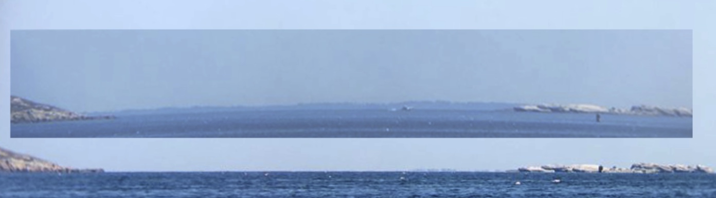
Also, I can't tell whether the two pictures you show are taken from the same place. The upper one shows the beach and the rocks, but is too low-res to zoom in on, while the lower one appears to show more of Fisherman Island, but not the beach. It's therefore not evident that the second picture wasn't taken from a higher elevation.
Maybe post a high-res copy of the first pic, through the binoculars, so we can actually work out what we're looking at? As Mick says, there's nothing clear in that photo.
If an object reappears with zoom then that object was merely too small to see. And if it doesn't, it may be beyond the curve, or it may still be too small.
At 16 miles, you're correct, very little of Mantinicus Isle should be seen, given standard refraction - though as we all know, famously from Rowbotham at Bedford Levels, the effects of refraction at or very near the surface of water can closely match the curvature of the earth.
However, I'm not really clear how far above the water you were. You say:
So was it from water level? From a rock just above water level? (How far above?) Or was it from your house?I just documented [Mantinicus Isle] with binoculars placed on a rock at water level...I've sailed there many times and watched our house (my vantage in these pics).
Also, I can't tell whether the two pictures you show are taken from the same place. The upper one shows the beach and the rocks, but is too low-res to zoom in on, while the lower one appears to show more of Fisherman Island, but not the beach. It's therefore not evident that the second picture wasn't taken from a higher elevation.
Maybe post a high-res copy of the first pic, through the binoculars, so we can actually work out what we're looking at? As Mick says, there's nothing clear in that photo.
Vision is limited by size and brightness, not distance, as can be noted by seeing stars many, many trillions of miles away.You answered yourself, our vision is limited. If extended (with zoom) and object reappears then vanishing point disappeared it from view, if zoomed in upon and is gone still, curve beyond horizon disappeared object. Lotsa zoomers out there reappearing distant objects...
If an object reappears with zoom then that object was merely too small to see. And if it doesn't, it may be beyond the curve, or it may still be too small.
In what way are 'clear' and 'refracted' incompatible?That sounds like magical thinking to me, I've sailed those waters, visibility is clear, not refracted.
Last edited:
Z.W. Wolf
Senior Member.
That sounds like magical thinking to me, I've sailed those waters, visibility is clear, not refracted.
Would you please make a comment on this thread? https://www.metabunk.org/all-the-ships-at-sea-a-pragmatic-test-of-earths-shape.t8954/#post-209084
I've been trying to get FE believers to comment on this subject, but response has been sparse.
eenor
Member
[off topic text removed] I appreciate Micks measured style so appreciate the mature discourse here at metebunk.
I took pics at -9 ft low tide pretty much at sea level, maybe 1 ft because of rock, those are the first set, i also lastly included a pic from the lawn above the beach 20 ft from sea level tops, my distance was calculated via iphone placing a marker on Matinicus and mapping from my place on the beach, but as said, 23 miles or 15 miles my naked eye quandary doesn't match curve calculations , even climbing on the roof of our two story cottage, i shouldn't see land, unless we have refractions that are off the average by huge amounts.
Ive watched our house as we sailed tens of miles away from it, watched it steadily retreat into the horizon, but not disappear. Invoking refraction as an explanation tickles my spidey senses as many theoretical science terms do, as a very incomplete explanation. I will continue to study it and add more here if i can. thanks all for your inputs.
Last edited by a moderator:
deirdre
Closed Account
the standard refracted for 20 ft is only 58' hidden.i also lastly included a pic from the lawn above the beach 20 ft from sea level tops, my distance was calculated via iphone placing a marker on Matinicus and mapping from my place on the beach, but as said, 23 miles or 15 miles my naked eye quandary doesn't match curve calculations ,
eenor
Member
To my understanding, "clear" visibility makes sense, matches reality and observation, "refracted" is a contortion to explain away said observation and magically raise whole islands into view. Optical effects include distortions usually in my experience (a spear bending in water, mirage, inversions, etc). Is there a real world test i can perform to confirm a 100%+ refraction at this relatively small distance enough to negate curve math and (at some magical point between observer and horizon) raise an Island behind said horizon back into view?I make Mantinicus pretty much bang on 16 miles from your stated viewing point. The elevation of the island seems to mostly range from 20-60 feet above sea level, with places up to 100 feet.
At 16 miles, you're correct, very little of Mantinicus Isle should be seen, given standard refraction - though as we all know, famously from Rowbotham at Bedford Levels, the effects of refraction at or very near the surface of water can closely match the curvature of the earth.
However, I'm not really clear how far above the water you were. You say:
So was it from water level? From a rock just above water level? (How far above?) Or was it from your house?
Also, I can't tell whether the two pictures you show are taken from the same place. The upper one shows the beach and the rocks, but is too low-res to zoom in on, while the lower one appears to show more of Fisherman Island, but not the beach. It's therefore not evident that the second picture wasn't taken from a higher elevation.
Maybe post a high-res copy of the first pic, through the binoculars, so we can actually work out what we're looking at? As Mick says, there's nothing clear in that photo.
Vision is limited by size and brightness, not distance, as can be noted by seeing stars many, many trillions of miles away.
If an object reappears with zoom then that object was merely too small to see. And if it doesn't, it may be beyond the curve, or it may still be too small.
In what way are 'clear' and 'refracted' incompatible?
Is there a real world test i can perform to confirm a 100%+ refraction at this relatively small distance enough to negate curve math and (at some magical point between observer and horizon) raise an Island behind said horizon back into view?
It's not refracting at "some magical point", the curves of the light paths are very gradual, over miles.
One thing you can do is observe the distortion of things, noticing in how in situations like this the portions of a distant tall object (like a building or a hill or mountain) that are close to the horizon get compressed.
A classic example is the view of Toronto.
(drag slider to compare)
You can make more accurate observations by looking at the stars, discussed here: https://www.metabunk.org/posts/207894/
Source: https://youtu.be/m-xXhrTG3Sk
However with your example there's just a very low island and it's hard to see any detail. I suggest trying to make a time-lapse (or at least a series of photos) from early morning to around 3PM, so you can see the effect of refraction changing over the day.
eenor
Member
Pretty sure we're looking at more than that much of the island from 20 feet up, as for my view through binoculars from a low tide rock? -9 ft at Low tide, remember. Photo isn't great, but details are plainly there.the standard refracted for 20 ft is only 58' hidden.
eenor
Member
It's not refracting at "some magical point", the curves of the light paths are very gradual, over miles.
One thing you can do is observe the distortion of things, noticing in how in situations like this the portions of a distant tall object (like a building or a hill or mountain) that are close to the horizon get compressed.
A classic example is the view of Toronto.
(drag slider to compare)
You can make more accurate observations by looking at the stars, discussed here: https://www.metabunk.org/posts/207894/
Source: https://youtu.be/m-xXhrTG3Sk
However with your example there's just a very low island and it's hard to see any detail. I suggest trying to make a time-lapse (or at least a series of photos) from early morning to around 3PM, so you can see the effect of refraction changing over the day.
I took pics at Low and high tide, two different days, second day had a light haze but island was clearly visible in all cases.
eenor
Member
Here's more at almost high tide about 10-20 feet above water, and on a rock just at sea levelI took pics at Low and high tide, two different days, second day had a light haze but island was clearly visible in all cases.
deirdre
Closed Account
I don't see the island in that last pic at sea level. do you?and on a rock just at sea level
Rory
Closed Account
Gotcha. I think probably like most people I took "clear visibility" to mean there wasn't any fog or haze or low cloud or mist, etc.To my understanding, "clear" visibility makes sense, matches reality and observation, "refracted" is a contortion to explain away said observation and magically raise whole islands into view. Optical effects include distortions usually in my experience (a spear bending in water, mirage, inversions, etc). Is there a real world test i can perform to confirm a 100%+ refraction at this relatively small distance enough to negate curve math and (at some magical point between observer and horizon) raise an Island behind said horizon back into view?
Refraction, meanwhile, isn't a "contortion", but a well understood and explained phenomenom of light.
For a real world test I would say you could film Mantinicus Isle over a period of time from one stable place with a decent zoom, and then show what your distant shot looks like compared with the entire island down to the water.
deirdre
Closed Account
No he doesn't. he is calling the temperature layers an inversion at 26 seconds in. You can see in your screenshot he is calling it a "superior mirage"Refraction or inversion? This guys calling it inversion (re view of Chicago skyline seen from Michigan). View attachment 28665
he says:External Quote:May 8, 2015 - Superior mirages occur when a large area of warm air sits over a layer of colder air, a phenomenon called a temperature inversion.
External Quote:"you should not be able to see it. However with the right conditions we have an inversion. we have cold air near the cold lake water, and some relatively warmer air above it."
Source: https://youtu.be/vbn9BBppR5g?t=27External Quote:Among the most interesting and puzzling optical phenomena of the atmosphere are the mirages. Mirages are caused by the way in which light passes through air layers of differing densities. As light waves move through the air layers, its path is bent or refracted toward the denser air. Strong mirages can trick the brain into thinking it sees something quite different from what is actually there. http://www.islandnet.com/~see/weather/elements/supmrge.htm
eenor
Member
Ok is it refraction or mirage? At what point does the island stop being in my view and become a superior mirage inversion refraction island? I've driven across many deserts many times, i know what a mirage looks like. I know what the effects of heat look like at a distance (distorted, mirrored, shimmering), Im not seeing how putting binoculars on a rock is tricking me... I know perspective creates the effects we see in difference between at sea level rock pix (yes somewhat distorted: from ocean surface movements, vapor, atmospheric distance, vanishing point intersection, and perhaps the supposed to be but severely lacking...curve?) and the higher up lawn view, where all of Matinicus is clear and plain to see, not distorted. I know the calculation for earth curve is not even remotely working, so far two different optical illusion effects have been invoked. Im not satisfied with these explanations, but if you all are...ok.
deirdre
Closed Account
-refraction just means the bending of light.Ok is it refraction or mirage?
-temperature gradients (including temperature inversion) is what causes light to bend. ie. density changes cause light to bend. just like a straw in a glass of water.
-the bending of light causes mirages.
There is refraction on FE too obviously or you would never see mirages.
when the curvature of the earth is greater than 100 feet elevation plus tree height (*black spruce can grow up to 50 feet)At what point does the island stop being in my view and become a superior mirage inversion refraction island?
but severely lacking...curve?)
the curve isn't lacking in your photos.
? what two?so far two different optical illusion effects have been invoked.
eenor
Member
Zoom inI don't see the island in that last pic at sea level. do you?
eenor
Member
Knowing it's not inferior or even inferior stooping (wasnt subtle), sounds like you are suggesting that it's a version of superior mirage or perhaps looming? Which would be strange because that requires a pretty uncommon inversion of a heat layer over a cold layer and this observation is common, constant, viewable in most conditions besides heavy fog and clouds (i even included a hazy day shot), we've been looking at it a long time. Here's another look from the lawn so you can see the non mirage like clarity. Also, if this is refracted imagry (from amazingly sustained uncommon atmospheric conditions) then when does it become "real" as i sail towards it?-refraction just means the bending of light.
-temperature gradients (including temperature inversion) is what causes light to bend. ie. density changes cause light to bend. just like a straw in a glass of water.
-the bending of light causes mirages.
There is refraction on FE too obviously or you would never see mirages.
when the curvature of the earth is greater than 100 feet elevation plus tree height (*black spruce can grow up to 50 feet)
the curve isn't lacking in your photos.
? what two?
eenor
Member
the stretching is from the binoculars, I"m kinda surprised you would inset my binoc photo on the non binoc to draw some kind of comparison...One thing from those images is that it's clear you can see a lot more of the distant island as you get higher up. That in itself demonstrates curvature.
View attachment 28654
You can also see a degree of stretching in the detail. Red line here is the horizon.
View attachment 28655
deirdre
Closed Account
if one is a non-binoc pic, then how come we can see the rocks to the right in both pics?the stretching is from the binoculars, I"m kinda surprised you would inset my binoc photo on the non binoc to draw some kind of comparison...
eenor
Member
it may be from a binoc pic that was centered (less lens distortion or "stretching"). Regardless, the lowered camera on the rock will have a different view with more distortions, all sensible re: perspective, surface layer and atmospheric interference. Curve should just hide 50 ft trees on a 100 ft elev island and the superior mirage requirements weren't likely in play as described above.
eenor
Member
from: http://aty.sdsu.edu/explain/atmos_refr/horizon.html
"What's the record for visibility without help from the silhouetting effect? I think that might belong to the report of the expedition led by Korzenewsky (1923), who reported seeing snow-capped peaks of a mountain range 750 km away."
the page is a fascinating quick read, with lots of assumptions and approximations...but apparently my observation is comparatively small potatoes. Rare looming indeed.
eenor
Member
, ok it's a dumb model, i laughed too.... But is it? I know I'm missing temperature layers here but isn't refraction somehow a bouncing off of "island" image upon inner curve of atmosphere? Like a projection? This is what the refraction diagrams suggest. But as i found with mirrored surface, any surface curve would invert and distort it. The Allauch skyline or clean hem of Matinicus would be distorted, inferior mirage style, not tricking us as real. Any ideas how can i test these mirage effects, or know of a real world simulation?
Rory
Closed Account
Can I suggest trying to stay on the topic of the photos you posted please? This thread is bouncing all over the place.
Is the above picture the one you want looking at? If so, can you post: the camera location; the elevation above the water; and what it is we're looking at (ie, the near island, and the land mass in the distance)?
Is that the highest resolution version you have of that pic?
Also, what are the four shapes that appear to be in between the two islands?
Maybe going to google earth and working out how much of the distant land mass is actually visible - ie, is any hidden, or none at all? - would be useful too.
Once accurate measurements and good pictures, etc are in, then we can see what's what. All talk of mirages and even refraction is premature, as far as I can see.
Cheers.
")
Last edited:
e thing from those images is that it's clear you can see a lot more of the distant island as you get higher up. That in itself demonstrates curvature.
This is the key thing for me. Notice that from low down close to sea level you can only see a bit of the island at the right hand end? Looking at the topo map, the highest point (103ft) on Matinicus Isle is towards the right-hand end of the island as viewed from Crescent Beach:
Rory
Closed Account
"Why does the 103 foot high Matinicus Isle appear to be significantly lower than the 31 foot high Marblehead Island?"
UPDATE: Apologies. I rushed that thought and got myself a little backwards. Doublechecked it later more carefully and realised I was wrong: Matinicus should appear lower than Marblehead, no matter what your world view.
Last edited:
Also, it may be worth thinking about the following:
1. The near island is Marblehead Island, with a maximum elevation of about 31 feet (about 2.5 miles away)
2. The far island is Matinicus Isle, with a maximum elevation of about 103 feet (16 miles away)
3. The near island appears significantly higher in your photo than the far island
4. As a quick estimate, assuming a flat earth, the camera would had to have been about 10-40 feet below the water level to produce a view like this (assuming all of Matinicus is visible, as you say)
5. Any camera elevation above the water level couldn't possibly produce a picture like this if the earth were flat: Matinicus should appear about two to three times higher than Marblehead
Can you show your working for this?
eenor
Member
I'm not asserting flat earth, I already said that, but Mick removed that portion of one of my comments for being off thread, I don't join groups, I'm testing my senses and environs. I've only said the curve calculation isn't working. My bowl experiment is based on these graphs found here: http://aty.sdsu.edu/explain/atmos_refr/horizon.html pretty common for explaining refraction effects. I think its very pertinent to the thread as its the basis of explanation so far.

eenor
Member
Perspective answers this very nicely without a curve, the assertion that Matinicus would be the same elevation or higher than Marble head would have to ignore perspective...ala short telephone poles in the distance compared to tall in the foreground.Perhaps a more pertinent, cut-to-the-chase approach to this photo would be to simply ask:
"Why does the 103 foot high Matinicus Isle appear to be significantly lower than the 31 foot high Marblehead Island?"
")
deirdre
Closed Account
can you show your perspective math for that?the assertion that Matinicus would be the same elevation or higher than Marble head would have to ignore perspective...ala short telephone poles in the distance compared to tall in the foreground.
eenor
Member
Perspective answers this very nicely without a curve, the assertion that Matinicus would be the same elevation or higher than Marble head would have to ignore perspective...ala short telephone poles in the distance compared to tall in the foreground.Perhaps a more pertinent, cut-to-the-chase approach to this photo would be to simply ask:
"Why does the 103 foot high Matinicus Isle appear to be significantly lower than the 31 foot high Marblehead Island?"
in the last bonoc photoCan I suggest trying to stay on the topic of the photos you posted please? This thread is bouncing all over the place.
Is the above picture the one you want looking at? If so, can you post: the camera location; the elevation above the water; and what it is we're looking at (ie, the near island, and the land mass in the distance)?
Is that the highest resolution version you have of that pic?
Also, what are the four shapes that appear to be in between the two islands?
Maybe going to google earth and working out how much of the distant land mass is actually visible - ie, is any hidden, or none at all? - would be useful too.
Once accurate measurements and good pictures, etc are in, then we can see what's what. All talk of mirages and even refraction is premature, as far as I can see.
Cheers.
I was standing on grass , near stairs, 10-15 feet above water? Others were taken from upon rocks at high and low tide, as previously shown. Is taken from a smart phone camera, yes this is best resolution. Next time i visit I'll bring a better camera, mount it on a boat and drive to Matinicus and we can decide when the island transforms from a mirage to actual. Well have to wait a year.
I've only said the curve calculation isn't working.
It has already been pointed out that near the horizon refraction is significantly different to standard atmospheric refraction. This is due to the cooling (or sometimes warming) effect of the ocean on the air immediately above it. You can't use a simple calculation to represent this, as it's affected by the shape of the temperature gradient.
Your images don't seem at all inconsistent with a curved earth and atmospheric refraction to me. You reference Andrew Young's page. There's lots of different type of near-horizon refraction phenomena described there.
http://aty.sdsu.edu/mirages/mirsims/loom/loom.html#looming
Again, I think the most useful thing here would be a morning to afternoon timelapse video showing how refraction changes through the day.
deirdre
Closed Account
so... you are saying that atmospheric distortion is the cause for the island lowering into the sea in the sea level shots.. but you insist that atmospheric distortion can not raise an image?it may be from a binoc pic that was centered (less lens distortion or "stretching"). Regardless, the lowered camera on the rock will have a different view with more distortions, all sensible re: perspective, surface layer and atmospheric interference. Curve should just hide 50 ft trees on a 100 ft elev island and the superior mirage requirements weren't likely in play as described above.
Weren't likely in play? what makes you think that? what was the date those photos were taken?
Rory is correct that you are bouncing all over the place, so I might be misunderstanding you.
Similar threads
- Replies
- 15
- Views
- 2K
- Replies
- 20
- Views
- 4K
- Replies
- 42
- Views
- 6K
- Replies
- 8
- Views
- 1K