Could The Gimbal Video Show an Atlas V Launch?

I hope an image is worth a thousand words:
geometry2.png
Not to scale, but mathematically accurate. Just an example, there could be many other scenarios for the cloud, like being higher just below the plane, but much shorter in length.
The image depicts 'LoS to target -2°", not "LoS to the horizon -2°", which is what you claim. Draw a line from the plane to the horizon (tangent to the sphere) then lean it down two degrees more, where does it point now? I'd make the drawing for you but I need to eat, see you all later
 
Last edited:
The image depicts 'LoS to target -2°", not "LoS to the horizon -2°", which is your claim. Draw a line from the plane to the horizon (tangent to the sphere) then lean it down two degress more, where does it point now? I'd make the drawing for you but I need to eat, see you all later
Not my claim. See post #124.
Where I wrote "LoS to target -2º" it means "Target is 2º below the horizon(tal)" (i.e., eye level), not "2º below the target". Sorry if it wasn't clear.
 
Not my claim. See post #124.
Where I wrote "LoS to target -2º" it means "Target is 2º below the horizon(tal)" (i.e., eye level), not "2º below the target". Sorry if it wasn't clear.
No problem, by 'you' I meant generally all those who claim etc etc. etc., not you specifically. But just for reference the claim which would destroy my model is that the -2° are relative to the horizon. I'm perfectly fine with the claim that the -2° means the ATFLIR looks sligthly downwards from the airplane. And.. if this argument surfaces again I'll use the drawing you posted, adding the line to the horizon and the other one 2 degrees lower, for a visual example, it's very nice. Thanks!

PS: I have to spend more time to debate these 2 silly degrees (straight on, in practice) than debating complex rotations of objects in 3D space, I take it as a sign I'm on the right road.
 
Last edited:
I would really like to hear something from @Mick West about all this, when it's convenient for him of course.
I've not looked at the details, but it's plausible that it's something very far away. I think to move forward you'd really need as much of date/time, location, and camera heading as possible.

In the meantime, I'm asking again if someone can be so kind to explain me how to upload files to MB
Zip the files, then click on "Attach Files" and attach the zip file.
 
I've not looked at the details, but it's plausible that it's something very far away. I think to move forward you'd really need as much of date/time, location, and camera heading as possible.


Zip the files, then click on "Attach Files" and attach the zip file.
Thank you @Mick West . If/when you can please look into some of the details (posts 106, 107, 108). I really think the case for Gimbal being the Atlas might be compelling, even without the additional data you rightly suggest, which have been long searched and discussed with few results. In a nutshell (and omitting the numerous caveats):
  • The model sets the pitch angle of the F-18 at the end of the video on the base of a consideration about the clouds (which in turn explains why the Gimbal looks to be at a fairly constant apparent height above the clouds), which are a few km away. It then succeeds in retrieving a reasonable distance travelled by the Atlas between the start and the end of the video, which critically depends on the pitch angle, hundreds of km away.
  • The model predicts a specific configuration of the clouds, which can indeed be found in actual satellite images of the cloud cover that day and (amazingly, I'd say, but see the caveats) they are roughly where the model predicts them (and the F-18) to be.
Blender files incoming [not yet.. I can't find the button.. sigh]
 
Last edited:
if this argument surfaces again I'll use the drawing you posted, adding the line to the horizon and the other one 2 degrees lower, for a visual example, it's very nice. Thanks!
Whatever you do with the graph, please make sure to be clear about your own additions and interpretations, which I may not agree with.
 
Sorry, I'm re
Whatever you do with the graph, please make sure to be clear about your own additions and interpretations, which I may not agree with.
Ah sorry, I did not realize it was your propriety! Sure thing, should I use it I'll ask you permission first by PM.
 
And.. sorry.. but I am dumb.. where do I find the 'Attach files' button? I've been looking for it since hours and I can't yet find it :(
 
Below the window where you reply. Left to the “Post reply“-button. At least, that is the case when you use ios-devices.

Edit: blue letters on white button in front of white backround
 
Another point of disagreement for me are the satellite images showing the cloud cover (from post #151, @TheCholla )

The Gimbal was recorded in the Jacksonville area. When you locate that city in the map, it appears in the north border of Florida, and north of Cape Canaveral. And the satellite images show there a low or no cloud cover.

satellite_ir_national_201501210140.png
From the same website, you can get a composite image:
sat_sfc_map_2015012102.gif

I don't know how they process the images to get that result. Anyway, what is intertesting are the cloud cover symbols, that show that in Jacksonville it was "one tenth or less but not zero", while in Miami it was "seven tenths to eigth tenths"

https://www.wpc.ncep.noaa.gov/dailywxmap/plottedwx.html
cloudcover.gif

So, now we could engage in another argument about whether the south of Florida can be considered the Jacksonville area (@Leonardo Cuellar in #154, see also video posted by @3db in #66 ), or if they were east enough to be inside the cloudy area, but what is clear for me is that these evidences are not compelling since they are being interpreted in different ways.

It would be more productive to reach to Ryan Graves (the pilot giving the talk in the video) and ask him specific questions such as the correct date, time (or at least daytime or nightime?), heading, if they could see it with unaided eyes (Atlas V surely had to be seen by eye!)... kind of things.
 
More weather informations for January 21st 2015, this time the wind at 400 millibars (~25000 ft):
Screenshot 2021-11-17 221614.jpg

The vectors show the wind direction, the color its amplitude. It's quite a coarse resolution data (2deg, or ~200km), but at this altitude there is not much of local variations in the wind, it's pretty much driven by the large-scale motions. The wind was definitely going eastwards (westerly wind) at 400 mb, off the coast of Florida and above. The pressure level was 400mb around 25000 ft where the fighter was, so I'm confident this was the wind direction. The wind patterns are quite similar on January 20.

The pilots saying "it's going against the wind" suggests Gimbal was going westwards, or towards the coast. If we follow this hint the pilots were then facing towards the coast when chasing Gimbal.
 
Another point of disagreement for me are the satellite images showing the cloud cover (from post #151, @TheCholla )

The Gimbal was recorded in the Jacksonville area.
How do you know this? Supercarriers and F-18 can range pretty wide. I know the exercise zone, Jax zone I think, is near Jacksonville (it's not easy to find infos on where it actually lies, or at least I couldn't find anything but generic statements such as 'east of..'). I know Jacksonville and West Palm Beach are pretty far apart, but yet again supercarrier groups + F-18 can range far and wide. Obviously any firm proof Gimbal was recorded anywhere near Jacksonville and at least down to Cape Canaveral would destroy my model. On this I agree!
 
Last edited:
Below the window where you reply. Left to the “Post reply“-button. At least, that is the case when you use ios-devices.

Edit: blue letters on white button in front of white backround
Thank you! I saw it, and it was just under my nose!! You saved me.

Here are the models:

- Gimbal vs Atlas 3 v020. blend is the reference model, all the other files are copies of this one for illustrative purposes

- Gimbal vs Atlas 3 v021.blend adds the measuring bar for the distance travelled by the Atlas (it's a dangerous thing to do in Blender, believe me)
- Gimbal vs Atlas 3 v022 clouds.blend adds 5 planes to roughly represent clouds
- Gimbal vs Atlas 3 v022 clouds solid.blend changes the clouds to parallepipedes for better visual results, and better adherence to reality (here I tinkered a little with the heights of the clouds, not much)
- Gimbal vs Atlas v023 maps.blend adds the Florida map in the background WARNING: it's not easy to manipulate this file, the point of view above the map is enormously far even for Blender, be careful if you zoom out.

Given 'as they are', do whatever you want with them (free unlimited licence I think is called?), but in case a reference to @Mauro would be appreciated.

Did I forget to thank also the Blender team for their program, which is very hard to tame but allows to do amazing things? I do it now!
 

Attachments

  • Gimbal vs Atlas models.zip
    703.2 KB · Views: 238
Last edited:
More weather informations for January 21st 2015, this time the wind at 400 millibars (~25000 ft):
Screenshot 2021-11-17 221614.jpg

The vectors show the wind direction, the color its amplitude. It's quite a coarse resolution data (2deg, or ~200km), but at this altitude there is not much of local variations in the wind, it's pretty much driven by the large-scale motions. The wind was definitely going eastwards (westerly wind) at 400 mb, off the coast of Florida and above. The pressure level was 400mb around 25000 ft where the fighter was, so I'm confident this was the wind direction. The wind patterns are quite similar on January 20.

The pilots saying "it's going against the wind" suggests Gimbal was going westwards, or towards the coast. If we follow this hint the pilots were then facing towards the coast when chasing Gimbal.
Thanks for the meteo data and for the interesting suggestion. Unfortunately I think my model cannot certainly pinpoint an exact location or heading for the F-18, the most it could do, but with a lot of math work, is to find a range of possible positions and headings could have had. So the suggestion is nice and now I go check where my models predicts the plane to be with respect to the coast, but even it turns out it goes the right direction, that's probably just luck :)


And here it is, @TheCholla : make out what you wish from it, I'd say it's at least 'consistent' with your prediction but, as I said before, it's just one point in a big space of possible configurations and positions. Remember the F-18 is off-scale: as depicted it is one kilometer long. The orange rays are the lines of sight to the Atlas.

1637188165708.png
 
Last edited:
I found this article in a local Jacksonville newspaper.
Talk to one of Gimbal's testimonial pilots.
This sentence could have a value:
"Matthew Spanopoulos said some things you see you never forget, especially the night he believes he saw a UFO four years ago."
https://www.news4jax.com/news/2019/...ieve-they-spotted-ufo-off-jacksonville-coast/
Indeed the reference to the night helps! Unfortunately the reference to Jacksonville doesn't, not at all. Now maybe a solution may be found which can place the F-18 near Jacksonville and still see the Atlas, but I doubt it (at least as I tried to do it) and I won't ever try to.

I think this is the best critique of my model as of now (originally coming, unreferenced, from @jplaza post #170): I cannot but confirm that, if the F-18 was near Jacksonville, my model is totally disproved (which by itself does not disprove the Atlas, but this is another matter). At the moment I can only say I'm going to look into this. Whatever I'll find, I'll let you know. If anyone has any suggestion or can point to other references, let me know. Good night everybody.
 
20/year actually boils down to one every 18 days, not that calculating how much is probable that with a launch every 18 days a launch will happen in a two-day timewindow is a straightforward task, but at glance I'd say in the order of 1/9, and not knowing how you define 'hugely' I cannot say much more. The coincidence becomes a little more surprising when all the geometrical details match (roughly, of course) on the scale of hundreds of kilometers, even more surprising when you see that they also match at a scale of a few kilometers (the clouds in the video) and yet even more surprising when it later turns out those clouds are really there, roughly in the expected position and geometrical aspect, in satellite pictures.
I was thinking "hugely" in terms of "starting to be to big a coincidence to believe it was just a coincidence." To my mind, a, let's say, 1/9 chance of happening just by unrelated happenstance is high enough not to be compelling -- especially when you consider other sorts of launches not in the count I found. That said, I remain intrigued with the possibility that the object is a launch. I'd not be surprised at all if that turns out to be the answr, if anybody ever can nail down the date and time of the video, especially considerng the other points you raise. It's just that, to me, there being a launch at some point in a two day span is not sufficiently unlikely to seem significant, in and of itself. Your mileage may vary, of course.
 
I was thinking "hugely" in terms of "starting to be to big a coincidence to believe it was just a coincidence." To my mind, a, let's say, 1/9 chance of happening just by unrelated happenstance is high enough not to be compelling -- especially when you consider other sorts of launches not in the count I found. That said, I remain intrigued with the possibility that the object is a launch. I'd not be surprised at all if that turns out to be the answr, if anybody ever can nail down the date and time of the video, especially considerng the other points you raise. It's just that, to me, there being a launch at some point in a two day span is not sufficiently unlikely to seem significant, in and of itself. Your mileage may vary, of course.
I'm really sorry and I apologize if my answer gave you the impression I was being snarky, that was not my intent at all (this extends to all my posts in this thread, but see the note(*)).

I readily agree with you that 1:9 odds are not that great evidence on which to base a theory upon (if they were, this whole thread would have ended with post #1), just I think I found some more 'coincidences' which make the theory more probable, that's all (and as usual, I may be badly mistaken).

I would also like to add that reasoning about 'probabilities of overlap' is by no means an invalid argument, however it's fraught with pitfalls and difficulties and should be approached with caution, not to expose the argument to possibly devastating attacks:
... you must [then] apply the same reasoning to any other possible cause beyond the Atlas, ie., if Gimbal in effect was a transdimensional craft, what's the probability that the Gimbal video [time] and the transdimensional craft flight time overlapped? Then every probability (of every possible cause) should be multiplied by the number you're asking for (which will in general be different for each cause), and that will be an advantage for the Atlas, because we know for sure there was an Atlas launch around that time, while we do not know for sure (at all, in fact) of any other possible candidate (I may be wrong on this! correct me in case), and what exists with ~100% probability tends to beat at this game what only [I]might[/I] exist, and with a low x% probability [on top of that] (were x large, then [I]we'd have[/I] another candidate, it couldn't have been overlooked). [URL]https://www.metabunk.org/threads/how-to-calculate-the-odds-of-something-being-true-vs-it-being-false-given-the-evidence-bayesian-inference.12131/[/URL] post #36. [/QUOTE][/time]


(*) Then I readily admit I'm no saint at all: I'm probably doomed to the lowest reaches of Hell should such a thing actually exist, ie.: a resurfacing of the -2° argument would probably increase my snarkiness by a couple orders of magnitude I guess. Indeed I already was snarkish when I wrote something on the lines of ".. then Gimbal should not be an UAP but an UUP (Unidentified Underground Object)". On the positive side, I also feel I anyway made some small steps on the ladder to sainthood lately, but that's just my feeling!
 
Last edited:
.. nothing interesting.. in fact I wanted to edit, but I replied instead


PS.: did I make any progress on the daunting Jacksonville question? Not yet sorry, unfortunately I also have to do some real, payed work at times, :cry.

PPS: does anyone of you live on the East Florida coast? I ask this because (who knows) maybe some local news outlet said something about jetplanes spotted flying east of West Palm Beach around Jan 20/1/2015 (most probably they didn't, but who knows), or maybe someone has an idea of how often jetplanes are spotted East near Palm Beach as compared, for instance, to Jacksonville, or where (with a reasonable certainty) the carrier groups love to prowl when training East of Florida, things like that. I doubt I may succeed in coming to know this directly from here (Italy) unfortunately. This would not prove anything by itself of course, but would be interesting to know (and should I ever come to Florida, I'd know where to better go to spot F-18s! xD).
 
Last edited:
There is are Naval airbases all along that coast. There's Mayport at Jacksonville and then the one at Virginia Beach.
 
There is are Naval airbases all along that coast. There's Mayport at Jacksonville and then the one at Virginia Beach.
Thanks a lot! I have and additonal question though, where is Virginia Beach in Florida? I can only find Virginia Beach, Va., but that's hundreds of km north of Florida.
 
Yeah that's the one, states borders and distances are a little different when you are the US Navy and have fighter jets and air to air refuelling and billions of dollars.
 
Yeah that's the one, states borders and distances are a little different when you are the US Navy and have fighter jets and air to air refuelling and billions of dollars.
Okay thank you! Virginia Beach is a bit too far from Florida for my model, but your above quoted sentence looks promising, thanks!
 
In the video below, from 17:20 onwards, Ryan Graves gives a good summary of the Gimbal events.
(Ryan Graves was one of the pilots participating in the training missions where the Gimbal video was taken).

He shows that the incident took place near Jacksonville (in fact that is even the title of his slide). The reason they went out to investigate was because of a number of interesting radar targets.
The ATFLIR video was taken "while stern converting the object and within 10 nm":

Screenshot 2021-11-18 130530.jpg

A "stern conversion" is a maneuver that:
is used to place the fighter in the rear quarter (RQ) of a non-aware or non-maneuvering target, In LAR for a Short Range Missile (SRM) employment, whilst also enabling the crew to visually identify (VID) the target during the turn (if weather conditions allow so).
Source

Schematic of a stern conversion maneuver by the blue plane:
Screenshot 2021-11-18 130149.jpg

He also tells this was an exercise to prepare for deployment to support Operation Inherent Resolve. Probably not an exercise that required the usage of Zulu time.
“[The] dates are 14 November 2004 for ‘FLIR1’ and 21 January 2015 for both ‘Gimbal’ and ‘GoFast.’"
Source

On top of that the Navy stated:
“the ‘Unidentified Aerial Phenomena’ terminology is used because it provides the basic descriptor for the sightings/observations of unauthorized/unidentified aircraft/objects that have been observed entering/operating in the airspace of various military-controlled training ranges.
(Same source)

 
I think there is a big elephant in the room here : the direction of scanning of the clouds.

In the analyses of the lines of sight, we have all agreed on the fighter being behind Gimbal, seeing it on its left, then being right behind it as it closes on it. Like simulated on this flight simulation :
https://www.metabunk.org/threads/gi...lines-of-bearing-and-or-dcs.11836/post-253998

The dispute is whether the line of sights can be parallel, or if they cross. This is very important, cause parallel line of sights allow for a steady trajectory, but if they cross, the trajectories become very hard to reconcile with a plane (or we need to start tweaking the rate of turns arbitrarily to make it work). So the parallel line of sights has been the consensus so far for Gimbal to be a mundane object moving steadily.

Now, bear with me. If we look at the video, the clouds move from left to right, i.e. they are scanned by the camera from right to left (or in another words we see more and more of the clouds to the left of the FOV).

Let's put this information into the equation, and consider parallel line of sights with a simple schematic. That gives us something like this :

Parallel (or at least non-crossing) line of sights
Parallel line of sights.jpg

See the problem ? If we are in this configuration, the camera should scan the clouds from left to right, i.e. we should see more and more clouds to the right of the FOV. This doesn't work.

Now, if the lines of sighting cross, it's possible to reconcile what we see with the clouds.

Crossing line of sights
Crossing line of sights.jpg
In that configuration we see more and more clouds to the left of the FOV. This is the configuration we see in the video. This to me suggests that there is parallax happening as the fighter moves around Gimbal relative to the background. Such parallax would not occur with parallel lines of sight.

With crossing lines of sight, it becomes very difficult to build a steady trajectory for a distant plane or a rocket that would not deviate too much from the lines of sight we have (you can try playing with the rates of turn here : https://www.geogebra.org/m/p4zhvaaf)

Something very important to notice is that the background stops moving at the end of the video, from azimuth angle L3 to R7. This happens while the plane rate of turn does not diminish. This is a strong constraint for the lines of sight to be close from each others at the end, hence for the object apparent motion to decelerate and stop, or change direction (which plane or rocket can make a sharp turn like this ?). Those last 5 seconds are very important and have been overlooked imo.
 
Last edited:
Agree, I explained something similar in this post.
If the circle of the jet curve in Mick's model is replaced by an ellipse representing a tightening circle (that ends with the same curve radius as the original circle), you'll see that the cloud movement matches that of the video. The consequence is that the object first needs to move before it is stationary to keep it in the FOV of the ATFLIR.
 
In the video below, from 17:20 onwards, Ryan Graves gives a good summary of the Gimbal events.
(Ryan Graves was one of the pilots participating in the training missions where the Gimbal video was taken).

He shows that the incident took place near Jacksonville (in fact that is even the title of his slide). The reason they went out to investigate was because of a number of interesting radar targets.
The ATFLIR video was taken "while stern converting the object and within 10 nm":

Screenshot 2021-11-18 130530.jpg

A "stern conversion" is a maneuver that:

Source

Schematic of a stern conversion maneuver by the blue plane:
Screenshot 2021-11-18 130149.jpg

He also tells this was an exercise to prepare for deployment to support Operation Inherent Resolve. Probably not an exercise that required the usage of Zulu time.

Source

On top of that the Navy stated:

(Same source)


This is all very interesting, thank you, I'll give it a deep look. I'll just notice at this moment that the 'stern conversion' manouver is not that relevant if the object was actually hundreds of km away and not 'within 10m' as the pilot thought, which is a common illusion [I really don't want to start a discussion about the reliability of pilot's reports now, I just notice there have been cases of pilots chasing and then shooting Venus (or maybe it was Jupiter or Sirius, sorry but I cannot dig up the reference here on the spot)]
 
I don't think the 10 nm was just a `thought' of the pilot, since they also had radar returns.
But I do admire your perseverance to continue to pursue a hypothesis that goes against everything the pilot and the Navy stated...
 
I think there is a big elephant in the room here : the direction of scanning of the clouds.

In the analyses of the lines of sight, we have all agreed on the fighter being behind Gimbal, seeing it on its left, then being right behind it as it closes on it. Like simulated on this flight simulation :
https://www.metabunk.org/threads/gi...lines-of-bearing-and-or-dcs.11836/post-253998
I find it hard to understand the meaning of the last sentence, sorry. What does it mean the figther being 'behind Gimbal' (I very much agree on the left side part)? About the (really cool) simulation, see later.


The dispute is whether the line of sights can be parallel, or if they cross. This is very important, cause parallel line of sights allow for a steady trajectory, but if they cross, the trajectories become very hard to reconcile with a plane (or we need to start tweaking the rate of turns arbitrarily to make it work). So the parallel line of sights has been the consensus so far for Gimbal to be a mundane object moving steadily.
I don't exactly understand here too. What I can say is that, in my model, the lines of sight are sub-parallel (at least when projected on a plane), this is necessary because it creates the same effect we see in the video, namely that the distance between the clouds and the Gimbal does not change much. This, by the way, then allows to retrieve a reasonable number for the distance travelled by the Atlas, 200km away (which strongly depends on the pitch angles, being that far). It may well be a coincidence, but it's pretty remarkable.

If then the lines of sight cross or not in 3D space is another matter. I copy here two pictures form my model. Lines of sight (almost) parallel when projected on a plane (they do cross, but I could have designed one 1 degree lower or such and they wouldn't have, and nothing would have changed significantly):


And lines of sight crossing when seen in 3D space (they are the same lines, they 'cross' near the origin):


About the tweaking of parameters: surely any parametrized model needs some value for the parameters to be input. I described my method as clearly as I could: I first tried a pitch angle of 40° for the F-18 at t=0, but this requires the F-18 to be more than 250km away (at the 60km altitude I had preset, I coul have just 'tweaked' that, but that would have been cheating), which was also a nuisance because I already had drawn the models with a 250km long line of sight and changing them in Blender was not exactly easy (but I could have done just that, and then use a more believable, less steep picth angle, but it would have been cheating). So I steeped up the angle to 50° and it worked: now the F-18 was about 200km away. The pitch at t=34s was derived by the consideration of keeping the lines of sight almost parallel (this was done by just rotating manually the F-18 model, no precision at all), considering how the nearby clouds looked in the video. This is all the tweaking I did. Nonetheless, I could derive the distance the Atlas travelled (200km away) during the 34s video (it was ~47km), definetly too low for an Atlas but in the right ballpark, and starting from underlying and 'guessed' (which means: more parameters) assumptions: ie. where on the Atlas trajectory did the video start? Even more basically: which was the real Atlas trajectory (I only could determine two points with certainty, not much, but better than nothing)? I have no doubts a little 'tweaking' could retrieve the very exact distance, just I don't like tweakings, I try to do reasonable models.

Now, bear with me. If we look at the video, the clouds move from left to right, i.e. they are scanned by the camera from right to left (or in another words we see more and more of the clouds to the left of the FOV).

Let's put this information into the equation, and consider parallel line of sights with a simple schematic. That gives us something like this :

Parallel (or at least non-crossing) line of sights

Parallel line of sights.jpg

See the problem ? If we are in this configuration, the camera should scan the clouds from left to right, i.e. we should see more and more clouds to the right of the FOV. This doesn't work.

Now, if the lines of sighting cross, it's possible to reconcile what we see with the clouds.

Crossing line of sights
Crossing line of sights.jpg
In that configuration we see more and more clouds to the left of the FOV. This is the configuration we see in the video. This to me suggests that there is parallax happening as the fighter moves around Gimbal relative to the background. Such parallax would not occur with parallel lines of sight.

With crossing lines of sight, it becomes very difficult to build a steady trajectory for a distant plane or a rocket that would not deviate too much from the lines of sight we have (you can try playing with the rates of turn here : https://www.geogebra.org/m/p4zhvaaf)

Something very important to notice is that the background stops moving at the end of the video, from azimuth angle L3 to R7. This happens while the plane rate of turn does not diminish, it evens increases. This is a strong constraint for the lines of sight to be close from each others at the end, hence for the object apparent motion to decelerate and stop, or change direction (which plane or rocket can make a sharp turn like this ?). Those last 5 seconds are very important and have been overlooked imo.
All what you say is really interesting, give me a little time to digest it :). What I can say at the moment is:
  • I did not consider at all the direction the clouds move in the Gimbal video, so yes, you may have spotted a fatal flaw of my model here. Thanks for the tip on using that information too.
  • The lines of sight crossing or not crossing is ihmo little relevant, see above. But I'm thinking at large scales here, you may be right at short scales.
  • My model uses a clouds configuration which is completely different: in it the clouds seen in the video are not sub-horizontal, they are sub-vertical. So I'm not sure if what you said really applies, but I'll check it out.
  • The background stopping at the end of the video is surely important. I already warned, in post #108, that :
I must also notice that I considered only the start and end points of the video, I’m sure lots could be gleaned by examining how roll angle and ATFLIR targeting direction (co)vary and this could very well give a mortal blow to my model, who knows. I can safely say it’s too much work for me.
So you are right, but considering the movements along the whole video is outside the scope of what I can possibly do.

Talking of scope of what I can possibly do we come to the simulation you referenced, which is very cool by the way! I'd really love someone do a simulation of what my model proposes (this maybe would convice me I'm deadly wrong)! Unfortunately this is again out of what I can possibly do, I can give all the necessary assistance to anybody who's willing to try, though. It shouldn't be difficult for one who knows how to do such things.
 
Last edited:
I don't think the 10 nm was just a `thought' of the pilot, since they also had radar returns.
But I do admire your perseverance to continue to pursue a hypothesis that goes against everything the pilot and the Navy stated...
IR contacts are one thing, radar returns claimed to be the same as the IR contact is another thing (if they weren't the Atlas solid boosters after all, as @Leonardo Cuellar suggested a long time ago, they detach before the first stage engine turns off. It might even explain the 9% increase in size of the Gimbal which has been reported, not that explaining that is in any way necessary to my model).

And thank you for the perseverance thing, by the way. About Navy and pilots' statements, I rememmber I also heard high-ranked military personnel swearing some guy had a stock of weapons of mass destruction, when he didn't (not saying it's the same thing! it's most probable that Navy personnel in the known are laughing as mad now reading this thread, or even most probable that they just don't care a bit about vetting the accuracy of statements about unidentified IR sources in the sky, expecially if they know that, whatever it was, it wasn't anything particularly notable).
 
Last edited:
One question if anyone can help me. In the reference cited by @Leonardo Cuellar (https://www.news4jax.com/news/2019/...ieve-they-spotted-ufo-off-jacksonville-coast/) which at the moment is (I think) the best argument against my model, given it locates the F-18 in a place where my model can't, I find this sentence:
The 2015 video was recently released. A veteran Navy pilot can be heard describing an object outside his cockpit window while on a military training mission off the coast of Jacksonville.

It's the first glimpse of the mission after the program that allowed this mission was defunded and declassified.
Anyone know which mission it was? Even better, where (more precisely than 'off the coast of Jacksonville') that exercise was done, or which kind of exercise it was, any info really? It's declassified they say, so this should be possible to do.
 
Last edited:
[dimesbag2]: think there is a big elephant in the room here : the direction of scanning of the clouds.

In the analyses of the lines of sight, we have all agreed on the fighter being behind Gimbal, seeing it on its left, then being right behind it as it closes on it. Like simulated on this flight simulation :
https://www.metabunk.org/threads/gi...lines-of-bearing-and-or-dcs.11836/post-253998

The dispute is whether the line of sights can be parallel, or if they cross. This is very important, cause parallel line of sights allow for a steady trajectory, but if they cross, the trajectories become very hard to reconcile with a plane (or we need to start tweaking the rate of turns arbitrarily to make it work). So the parallel line of sights has been the consensus so far for Gimbal to be a mundane object moving steadily.

Now, bear with me. If we look at the video, the clouds move from left to right, i.e. they are scanned by the camera from right to left (or in another words we see more and more of the clouds to the left of the FOV).

Let's put this information into the equation, and consider parallel line of sights with a simple schematic. That gives us something like this :


Parallel (or at least non-crossing) line of sights
Parallel line of sights.jpg

See the problem ? If we are in this configuration, the camera should scan the clouds from left to right, i.e. we should see more and more clouds to the right of the FOV. This doesn't work.

Now, if the lines of sighting cross, it's possible to reconcile what we see with the clouds.


Crossing line of sights
Crossing line of sights.jpg
In that configuration we see more and more clouds to the left of the FOV. This is the configuration we see in the video. This to me suggests that there is parallax happening as the fighter moves around Gimbal relative to the background. Such parallax would not occur with parallel lines of sight.

With crossing lines of sight, it becomes very difficult to build a steady trajectory for a distant plane or a rocket that would not deviate too much from the lines of sight we have (you can try playing with the rates of turn here : https://www.geogebra.org/m/p4zhvaaf)

Something very important to notice is that the background stops moving at the end of the video, from azimuth angle L3 to R7. This happens while the plane rate of turn does not diminish, it evens increases. This is a strong constraint for the lines of sight to be close from each others at the end, hence for the object apparent motion to decelerate and stop, or change direction (which plane or rocket can make a sharp turn like this ?). Those last 5 seconds are very important and have been overlooked imo.

[Mauro]
All what you say is really interesting, give me a little time to digest it :).

All what you say about the direction the clouds are seen moving in the video and about the lines of sight crossing or not is perfectly true.

I find the movement of the clouds as seen in the video consistent with my model: they move as expected for an airplane skirting a (sub-vertical) wall of clouds on its left and pointing a camera left, slightly above the upper rim of the wall of clouds, as the model predicts.

The cloud movement stopping near the end of the video is surely an interesting point as already noted, but I cannot really add anything more:
I must also notice that I considered only the start and end points of the video, I’m sure lots could be gleaned by examining how roll angle and ATFLIR targeting direction (co)vary [add: and the clouds appear to move in the video] and this could very well give a mortal blow to my model, who knows. I can safely say it’s too much work for me.
 
Last edited:
One question if anyone can help me. In the reference cited by @Leonardo Cuellar (https://www.news4jax.com/news/2019/...ieve-they-spotted-ufo-off-jacksonville-coast/) which at the moment is (I think) the best argument against my model, given it locates the F-18 in a place where my model can't, I find this sentence:

Anyone know which mission it was? Even better, where (more precisely than 'off the coast of Jacksonville') that exercise was done, or which kind of exercise it was, any info really? It's declassified they say, so this should be possible to do.
The Mission was called COMPUTEX.
After that the USS Roosevelt was deployed in the Arabic Gulf.
 
I'm really sorry and I apologize if my answer gave you the impression I was being snarky...
No snark detected on my end, I was just interested in how likely or unlikely a rough coincidence of a launch with the UFO incident might be. We're all good!
 

  • In the video below, from 17:20 onwards, Ryan Graves gives a good summary of the Gimbal events.
    (Ryan Graves was one of the pilots participating in the training missions where the Gimbal video was taken).

    He shows that the incident took place near Jacksonville (in fact that is even the title of his slide). The reason they went out to investigate was because of a number of interesting radar targets.
    The ATFLIR video was taken "while stern converting the object and within 10 nm":

    Screenshot 2021-11-18 130530.jpg
    I know I already answered saying I don't think the 'stern conversion' manouver matters much, because the pilot could have been badly mistaken about the real distance of the IR source in the sky. But thinking about this it came to my mind that... and here followed a discussion which seemingly supported my theory but actually was a colossal blunder on my part. But given it would now be cheating not to mention it, and given this 'stern conversion' thing might shed some light on the evolutions in the sky of the F-18, I'll talk a little about the 'stern conversion' manouver, as reported by @Itsme:
1637255950582.png


The manouver as depicted (even if irrelevant from some points of view if the pilot was mistaken about the neareness of the IR light) is not consistent with my model. While the video was taken, in my model, the airplane has to turn left, maybe possibly it could go straight but surely not turn to the right. However the manouver as depicted is also inconsistent with the Gimbal video, given the F-18 was banked on the left (*) and (for what I know) an aircraft cannot bank left and then turn right (maybe the F-22.. who knows, I really doubt an F-18). So we can be sure the pilot could not talk about a 'stern conversion' as depicted (unless it was executed at a different moment than the video, in which case it's irrelevant).

So now the question for people who know something more about fighters than I do: which kind of geometrical situation, involving a fast-moving, supposedly near, target on the left of the jet requires a left turn to be made? Could it be described as a 'stern conversion'? Yeah I know, pretty much convoluted and probably ambigous question, but if you have anything to say about it I'd be glad to hear.


(*) Which of course is the reason why I had my airplane turn to the left in the model. The model would also work with the F-18 turning right I think, with the F-18 placed to a completely different position than now, just it would become inconsistent with the roll (bank) angle data from the video.
 
Last edited:
https://www.theblackvault.com/docum...ially-acknowledged-encounters-with-phenomena/
And later on they give the Jan, 21st date for both Gimbal and GoFast.
A small bit of evidence: 2015-01-25 of appears in the EXIF data from the original .WMV files released by the DoD
2021-11-18_08-55-54.jpg

However the time difference between the two is 2m11s, but the second time codes at the start of Gofast and Gimbal are 4220 and 5245, a difference of 1025 seconds, or 17m5s.

Hence it seems like the videos must have been taken before 2015-01-25 02:27:05. Not super helpful, but consistent with the Jan 21 date
 
Thank you @Mick West. Unfortunately the exact date is a vexed and intractable question, indeed I did steer clear from using the date as a premise in my model, even if I of course stated the date of the Atlas launch and, more interestingly, I noticed that satellite meteo data about the cloud cover on the possible date range could be useful (as apparently they indeed were, even if this a different topic).

The vexed question is: were the (unknown) Navy personnel who talked to the Black Vault guys, reporting a 'January 21' date, thinking in terms of Zulu/UTC (then it's probably Atlas) or EST (then probably no Atlas) time? I see no possible way to decisively answer this question (unless fresh new informations are found, of course), so I simply left the date out from the premises (check post #107). If my model turns out to be anything good, then we may discuss about the vexed date question again, but I'd rather not do it now, given my model has not yet been demonstrated to be any good (nor decisively refuted I think, but this is yet another matter).

Your piece of evidence is nice, I'd love to have your skills in data mining, really, but unfortunately it's consistent with both a 21st and a 20th January date. But thanks!
 
Last edited:
I have better examined what I think is the most serious (and potentially fatal) objection against my model: the Gimbal video was reported to have been filmed somewhere east of Jacksonville. I have to say, you have a point here, and a big one indeed. I documented myself a bit about COMPTUEX 2015 (*) and the military maritime exclusion zones near the East Florida coast: I can see no obvious reason why the F-18 could have been so far South as I proposed. I could start arguing about sources reliability and air refuelling and similar things but I would not even succeed in convincing myself.

However not all is lost for the Atlas (and, hopefully, my model). I was convinced that there was no way to place the F-18 northwards of Cape Canaveral, due to a strange 'parity' problem with the turn direction of the F-18 needing to stay on its left side, but from a preliminary test I think I was too pessimistic. This requires a different turn rate for the F-18 (but always in the left direction) and a different pitch angle for the F-18 at time=34s, both of which should not be a problem because they are both (broadly)unconstrained parameters. So I think I can place the F-18 along a stripe roughly parallel to the Atlas trajectory and northwards of it, thus in the Jacksonville area (as it was possible, roughly symmetrically, on a stripe southwards of Cape Canaveral).

That's all for the moment, it'll take me some time before I can build a decent Blender model which can be decently presented, so no sooner than tomorrow for sure. As a minimum, by tomorrow I will be able to let you know if it really works or not.

(*) Funny to know, apart from UAPs, a visiting French nuclear attack submarine was reported to have 'sunk' the Roosvelt and some escort ships during COMPTUEX 2015. The French say it happened, the US Navy denies. A topic for another thread maybe! xD For sure, submarines are bad beasts, very very bad beasts, expecially (but not only!) when running on nuclear power.
 
Last edited:
I may have found a solution. No Blender model for now, but I can give a qualitative 'frame-by-frame' description of the encounter.

THE ENCOUNTER STARTS

The F-18 is flying west, with a bank of clouds on his left, the upper rim of the clouds is higher than the F-18. The pilot sees on his left, up above the rim of the clouds, a fast-moving light. This is the situation:

1637288974858.png

The pilot thinks the Gimbal is nearby, just above the clouds near him. He wants to do two things: one is a 'stern conversion' maneuver (as suggested by @Itsme), meant to bring him to chase the target from the rear, in a favorable firing position:
1637289296707.png

To do this he needs to bank the aircraft left, to be able to turn left. He also wants to bring his ATFLIR on the target, but the ATFLIR is below the left wing, and he's banking left (the left wing tip is lower than the right one). So he needs to pitch up the nose a lot (possibly to the limits of the flight envelope) to get the target into the ATFLIR LoS, and he surely throttles up the engines. He would also like very much to gain altitude of course, but he's too pitched up, he simply does not have enough thrust from the engines, the best he can do is to keep the same altitude.

The situation is the same as in the first drawing above, but now think the line of sight is the ATFLIR's line of sight.
This is an approximate vertical projection along the AA line marked on the first drawing:

1637289650703.png


Now the ATFLIR is locked on the target and the F-18 has begun a sharp left turn (while pitched up). The pilot turns on the videorecorder.


THE VIDEO

I only have one frame:

1637289799844.png

The F-18 is in the middle of the left turn, the Atlas is fast moving eastward. The line of sight of the ATFLIR passes, as before, just over the rim of the clouds. Notice also the angle the ATFLIR does with the airplane axis has decreased.


END OF THE ENCOUNTER

1637289952123.png

The F-18 has almost completed the stern conversion maneuver (nothing more than a sharp arc of a circle in this case): the pilot expects to find the target about in front (and a bit higher) of him, but it has suddendly vanished. Maybe it was when the Atlas first stage engine turned off, maybe the F-18 just went into the cloud and lost contact, or the Atlas disappeared behind other clouds somewhere along the LoS, this can't be known. In any case the video ends before the target disappears, and approximately at the end of the marked trajectory the Atlas first stage engine turns off (or the stage detaches, I'm not sure about the exact sequence of the first stage separation of an Atlas. However it actually is, at the end of the trajectory the Atlas stops being so a strong IR emitter as it was before). Notice also the angle the ATFLIR does with the axis of the plane is now slightly slanted on the right (6°R, it started from 54°L as we see in the video).

Nothing is seen in the video which suggest the Gimbal is gaining altitude, as the Atlas is instead doing at a fast rate (tens of km during the 34s of the video). This is due in great part to perspective effects (the target is actually very far from the F-18, say 200km just to give a possible figure). How the perspective works is difficult to explain with words, I'd really need the Blender model now, but the basic idea is that the F-18 starts with a high pitch (the nose is pointing steeply up) which then lowers as the encounter proceeds, this even if the Atlas is actually rising up fast in the sky. You can get an idea of how it works by looking to my previous posts with the old Blender model (I don't want to copy it here not to clutter this post with outdated informations): the overall geometry is very different and the F-18 turns with too slow a turn rate there, the clouds would flow the other direction, @TheCholla was right), however the effect of the perspective is similar, the pitch angle decreased by ~25% in that model, while keeping the Atlas locked on track. Another reason is the unusual geometry with which the video was taken, which makes it hard to figure out istinctively what is moving which direction (see also the next post about why the clouds look to move in reverse), and then the clouds, which are 'fractal' in shape and do not give any firm reference point for our (mine for sure, at least) brain to hold on.


There is yet one important thing to explain: why the clouds in the Gimbal video are seen to move as they do (thanks @TheCholla for pointing this out to me). It deserves another post though.

----> Continued next
 
Last edited:
WHY THE CLOUDS MOVE 'BACKWARDS'

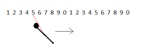
This was indeed a puzzle. It's not easy to explain with words, let's start with an F-18 flying straight with a tall wall on his left, the ATFLIR pointing left. On the wall there are visual features, in this case numbers. Looking from above we see this (the numbers should be drawn orthogonal to the screen but they would just look as a row of dashes, the wall is vertical. The F-18 is depicted as a line with a round head to mark its direction):

1637290742638.png

While the F-18 is moving the ATFLIR sees different increasing numbers:

1637290816269.png
For instance the number '7' enters the field of view from the right side, then it flows to the left and disappears on the left side of the field of view, followed by '8', '9' etc. This is quite normal, but the Gimbal video shows exactly the opposite.


Now imagine the F-18 does a sharp left turn, almost on the spot, and keeps (for now) the angle between the ATFLIR LoS and the airplane axis constant. This is what happens:

1637291054226.png
The number the ATFLIR sees is now '6': the number has decreased. This means the flow of the numbers reversed, the '7' came back from the left side, then the '6' followed. This is exactly what we see in Gimbal.

But there's an additional complication: the ATFLIR Gimbal does not stay steady, it rotates too, and towards the right (relative to the airplane axis), so this rotation tends to cancel out the backward flow. Indeed were the Gimbal rotation matched to the airplane rate of turn we would see the numbers on the wall stay steady (for the time it takes the plane to complete the turn).

This also means that if the plane turn rate exceedes the ATFLIR turn rate we will see the numbers (or the clouds) moving in reverse in the video, just slower than what happened when the ATFLIR was kept steady. (*)

The ATFLIR rotates a total of ~60° in ~34s, once the F-18 turn rate exceeds ~60/34 =~ 1.765 °/s the clouds start moving backward in the video. That's a low turn rate for a fighter, the high pitch will make matters worse of course but I guess an F-18 can exceed that rate of turn even in that case.

He is really a great pilot, kudos.

This is the last drawing: it depicts the clouds flow, from before the video starts (F-18 going straight west) up to the end of the video. Notice the ATFLIR at the end is pointing slightly right (the angle should be 6°) but the 'numbers' seen on the clouds wall are still decreasing :

1637291978555.png


04:20 in the morning here.. good night everyone

(*) final note: why the rotation rate of the ATFLIR is lower than the turn rate of the F-18? Because the ATFLIR is tracking the Gimbal, which is fast moving East, see again the 'cinematics' in the previous post where you can (roughly) see the F-18 heading, the ATFLIR declination and the Gimbal position, this makes it easier to visualize.
 

Attachments

  • 1637291854344.png
    1637291854344.png
    1.7 KB · Views: 165
Last edited:
Back
Top