Circle Sweeps, HAARP Rings, and Scalar Squares are Often From the Birds.

Funny there's another non-precipitation return on the Buffalo image series that TWC used. SE of Buffalo there are some hilltop wind farms that in in the line of sight of of the Buffalo base scan.

It's also funny that the conspiracy folks led me to "discover" the migrating birds on radar for myself. I'd always ignore non-precipitation clutter on images. I knew about refraction resulting in the radar bouncing off of objects on the ground such as when Wakefield VA pics up the Chesapeake Bay Bridge Tunnel in a deep inversion over a cold Chesapeake Bay bends the signal to the ground. But that type of clutter produces very bright distinct reflections. It is afterall cars and trucks driving on the bridge that are reflecting the signal. I've seen interstates in the midwest show up like that on that last cold calm night before a warm front. Diffuse clutter surrounding the radar was always to me just night critters flying about and I thought the brighter nights were when an inversion kept the signal lower. It was researching the topic in response to conspiracy theorists that I found the seasonal pattern to nocturnal clutter as well as the relationship of the nocturnal clutter to weather fronts and known migratory flyways. The nights with widespread clutter were in weather when temperature inversion was unlikely and relative velocity images showed not erratic movement around the radar but directed movement from N-S in the fall and S-N in the spring. Then I discovered that I was late to the party and that people were already studying noturnal flight and migration in a field known as aeroecology. People were using radar to locate bat and purple martin colonies. People were using radar to track broad cross regional migrations.

I guess that one positive is that I did learn something fascinating. But that new knowledge required that I already understood how radar worked, that the image on radar is a computer's interpretation of the reflected signal from the radar itself. The believers that do not understand radar or what clouds types there are will never make such discoveries. Heck, they are unable to discover real anomalies because they do not know what is really normal.
 
It's also funny that the conspiracy folks led me to "discover" the migrating birds on radar for myself. I'd always ignore non-precipitation clutter on images.

I guess that one positive is that I did learn something fascinating. But that new knowledge required that I already understood how radar worked, that the image on radar is a computer's interpretation of the reflected signal from the radar itself. The believers that do not understand radar or what clouds types there are will never make such discoveries. Heck, they are unable to discover real anomalies because they do not know what is really normal.

For a time I was taken in by the Conspiracy Theories, It started with 9/11 and included Chemtrails. I was in a band at the time, about the time we'd finish rehearsal, "Outthere TV" would come on a local channel, and we'd unwind with a couple of beers as we watched. I contributed to the writing of and put the music to the video I've linked below. Funny thing is, by the time I was done ripping off the photos and reading the articles and links to those articles, I'd pretty much changed my mind. It helped growing up in a home with a research chemist as a father who instilled an appreciation of the scientific method, even though I chose a path in the arts, it pulled me back from the rabbit hole before I was too deep.

By searching to debunk some of these theories, I've learned a lot about subjects I thought I had little interest in. They did make me "Look Up" I'm just glad I've learned the science behind it and can now ignore the hysteria.


Maybe you'd consider adding a longer version of that story here?
https://www.metabunk.org/forums/out-of-the-rabbit-hole.29/
 
Last edited:
Interesting how "they" have now suddenly stopped "pulsing" the mid-central to south eastern United States. No more "electromagnetic attacks", no more videos from Dutch or Rush. I guess "they" only like to "pulse" such vast areas when they can use the birds migrating cover story.
 
Like clockwork, Dutchsinse is as reliable as the birds themselves every spring and fall migration period......

https://www.facebook.com/photo.php?...2.106418.296574443728320&type=1&stream_ref=10


31 March 14.JPG


Birdcast better be careful in its use of words in this update. In the very first line they say "a pulse of favorable conditions that produces weekend flights..." Oh no, not a "pulse" :)

http://birdcast.info/forecast/regional-migration-forecast-28-march-4-april-2014/

Again Dutch, I ask the same questions as I did last fall. Why is just this area getting "pulsed"? Why is the west coast ALWAYS spared this frequency pollution? WHY do these blooms only appear in the late evening to early morning hours?

Some good reading concerning radar data as it relates to bird movements in the atmosphere:

http://virtual.clemson.edu/groups/birdrad/COM4B.HTM

http://virtual.clemson.edu/groups/birdrad/

A good site for updates on bird migrations as seen on radar:

http://badbirdz2.wordpress.com/
 
A "confirmation" from Dutch is almost certainly coming should today's (3/31/14) convective outlook produce anything resembling severe weather. Right now there are just general thunderstorms in the area of his "haarp ring outbreak" but even that might be enough to warrant a follow up from him. He shoehorns anything that will work.

outlook.JPG

http://www.spc.noaa.gov/products/outlook/day2otlk.html
 
Yep, right up the Mississippi Flyway from Texas to Wisconsin on southerly winds circulating around a low pressure system over the border of Wyoming and Nebraska. 'Tis the season.


sfc_map-12.gif

north-america-migration-flyways.jpg


Trying to explain the science of meteorology to YouTube "Keyboard Warriors"?

A Sisyphean task, like pushing a rope up a hill....(**)

Or, "herding cats" (Which of course can be done by tossing a crumpled ball of paper, or using a laser pointer....usually).

Or???:


Satire (or, "Catire"??) folks!!!

(AND yes, I am a man who appreciates the cat...I like dogs too, though!)

But I'm neither here, nor there, on turtles:
 
Last edited:
A "confirmation" from Dutch is almost certainly coming should today's (3/31/14) convective outlook produce anything resembling severe weather. Right now there are just general thunderstorms in the area of his "haarp ring outbreak" but even that might be enough to warrant a follow up from him. He shoehorns anything that will work.

outlook.JPG

http://www.spc.noaa.gov/products/outlook/day2otlk.html

Well, that was an easy call to make. Right on queue Dutch. Facebook and YouTube full of "confirmation" posts and videos, including this:


Dutch claims a tornado forms near Jackson, MS within a "haarp ring" "real time" as he states it, apparently once again dispensing with the 24-48-72 or whatever-it-is hourly interval in between such events all together. Once again he bases this upon those labels that are generated by Intellicast and Weather Channel software, labels that are both unreliable and often inaccurate. In fact, the label that pops up on the Weather Channel map in his video says "possible tornado" but that's enough for Dutch for a confirmation.

Once again he mistakenly says the acronym "RF" as see on Doppler radar velocity products means "Radio Frequency". Heavy, heavy sigh........no Dutch, for the one billionth time, it means RANGE FOLDED......

rf.JPG

And, interestingly enough, he is shown using the Storm Relative Velocity product, which is one of the most useful radar products available to identify tornado vortex signatures within a storm. However, he also demonstrates exactly how clueless he is in his feeble attempt to convince his viewers he knows what he is doing, instead focusing on the aformentioned "RF" rather than hunting for such signatures.

Storm Relative Mean Velocity is a product that is simply base velocity (wind velocity parallel to the direction of the radar beam either toward or away from the radar) with the average storm motion subtracted out. When storms are moving quickly, this makes it easier to spot rotation which might be masked out by the motion of the storm. In other words, the SRMV product displays wind velocity data as if the storm itself is motionless. It DOES NOT show "Radio Frequency" o_O

Explanation of Base Velocity:

http://forecast.weather.gov/jetstream/doppler/basevel.htm

Explanation of Storm Relative Velocity:

http://forecast.weather.gov/jetstream/doppler/srm.htm

A good tutorial of radar imagery:

http://www.srh.noaa.gov/jetstream/doppler/ridgeimages.htm

No severe weather reports anywhere near his "haarp ring outbreak" whatsoever from NOAA, just a few in Minnesota. No reports of hail in the Tulsa, OK area either, as he claims on an earlier Facebook post . No reports of tornadoes in that area. Nothing.

http://www.spc.noaa.gov/climo/reports/today.html

spc 33114.JPG
 

Attachments

  • dutch 31 march 14.JPG
    dutch 31 march 14.JPG
    303.8 KB · Views: 547
Hell most of his followers think that the colors on the radar depict temperature as they will often refer to reds and oranges as "hot". He nor they have any understanding that the radar detects a very narrow band and that the colors are false colors meant to illustrate the "brightness" of the reflection for the viewer.
 
His "haarp ring" looks like bright banding, the increased reflectivity when precip that starts as ice or snow begins to melt as it falls into warmer air below. In this case the air immediately below the melting layer is also very dry and the returns are weak which translates into light precip that started as snow, melts between 10,000' - 12,000' and sublimates around 6,000' to 8,000'. The concentric "ring" effect is from the circular sweep of the radar at different angles so the beam slices through a given altitude, in this case the melting layer, closer to the station as the angle of the radar dish increases.

http://wx.db.erau.edu/faculty/mullerb/Wx365/Bright_band/bright_band.html


Here's the Skew-T diagram from Jackson, MS near the same time-frame showing the dry air immediately below the layer at 0 C.

[Broken External Image]:http://weather.uwyo.edu/cgi-bin/sou...AR=2014&MONTH=04&FROM=0100&TO=0100&STNM=72235

This was right ahead of the boundary between warm moist air from the south and cooler drier air from the north as winds circulate around a strong low over the upper midwest.

sfc_map-12.gif


He's claiming 'victory' over another auto-detect TWC tornado label over Tulsa, OK which happens to be one of the radars that picked up the March 30/31 bird migration. He doesn't even know where to begin in using the plethora of radar data available that would confirm or deny those auto-detect labels. TWC/Intellicast's software produces a lot of "false positive" labels too. He's not looking for Hook Echoes, Velocity Couplets or anything else, he just kinda plows blindly through different radar products like Echo Tops looking for scary color patterns. Personally I didn't see anything in the radar signatures from either location that would indicate a tornado, or damaging winds or large hail. All dutch does is drool over those unreliable labels and go on and on about "RF is radio frequency", betraying his ignorance of a very basic concept in weather radar, Range Folding.

This whole insistence that RF/purple is radio frequency is completely illogical from the standpoint of keeping an alleged covert weather modification operation secret anyhow. Why would they modify the weather with "frequency" yet at the same time blatantly advertise an otherwise ultra-secret covert program by including said frequency data in radar maps available to anyone in the world? :confused:
 
See how easy it is? Just take a look at the convective outlook from the Storm Prediction Center, then find anything on a radar in the concerned area that your all-believing viewers will swallow, call it a "haarp ring", "scalar square", "frequency pollution" or some other type of mumbo-jumbo, sit back, wait for the weather to arrive, then claim yet another confirmed weather modification event. I am predicting there will be more "confirmations" from Dutch riding the coat tails of his March 31st post, which was examined earlier in this thread.

spc 2 april.JPG

He also does not seem to understand the criteria needed to issue watches and warnings. Such notifications do not go out for EVERY thunderstorm. And once again he is basing his statements on one of those faulty labels generated by the Weather Channel and Intellicast. Apparently, hearing thunder is all that is necessary to issue a warning according to him.

calls out nws.JPG

Link to a good FAQ that answers some general questions about why defines severe weather as well as watches and warnings:


http://www.spc.noaa.gov/faq/#4.1
 
Correct me if I'm wrong...but isn't 'YouTube' a source for profit, for those people who post videos and acquire subscribers and thus, "Views"?
(ETA: Since the company known as "Google" acquired "YouTube" some years ago)
http://www.nbcnews.com/id/15196982/ns/business-us_business/t/google-buys-youtube-billion/

Doesn't seem to matter if the content is 'accurate' or 'factual'.

But, responding to such obvious BUNK is, indeed, frustrating.

I once left a comment for one of his HAARP videos, in which I called him out about lying to his "fans" that HAARP hadn't been shut down. His response was very telling. He sent me a private message in which the only point was that "You haven't produced anything, so shut up". The fact of the matter is, he begs for money on Facebook while trying to drive people to YouTube for either profit, or ego gratification. It's amazing that he's still pushing the hoax that HAARP was never shut down.
 
Last edited:
Hoooboy, now "haarp rings" can vaporize storms too. And RF is a duality.

You know you're out there when you have to start your own piece with... "Not an April Fools joke."

http://dutchsinse.tatoott1009.com/4...inds-and-tornado-real-time-over-dallas-texas/

Not an April Fools joke.

4/01/2014, at approximately 9pm CT, a series of strong cell storms broke out West of Dallas Texas.

These cells were producing damaging winds, hail, and a strong detection of a possible tornado.

As the storm was nearing Dallas Texas, an odd thing occurred…. a series of RADAR pulses / “HAARP rings” were targeted at the coming storm. Specifically hitting the storm with a pulse which creates a sudden NEGATIVE VELOCITY across the region.

Amazing!
Content from External Source
In this case, the "rings" were refraction off a strong inversion layer being picked up at different radar dish elevation angles. It looks like what he calls a "sudden negative velocity across the region" was a change of Volume Coverage Patterns in response to an approaching supercell storm. The storm actually did produce large hail, some wind damage and almost formed a tornado according to radar showing a velocity couplet and hint of a hook echo.

Oh, and there is no such thing as a "strong cell storm". "Strong cell" is just a term used on Intellicast/TWC auto-detect labels. I've seen areas of just moderate rain labeled "strong cell" by Intellicast/TWC so I'm not sure what their definition of "strong cell" actually is. The particular storm in question however was a supercell, the other types of storms are single cell, multi-cell and squall line.

As the storm was pulsed, real time, the storm died, the hail stopped, and the possible tornado (rated 15 out of 15 in strength) ceased to be detected.

You can see the pulse hit the incoming storm in NEGATIVE velocity. then, you can see heavy RF inundate the storm (coded in purple in the relative mean velocity feed)
Content from External Source
What does "hit the incoming storm in negative velocity" even mean? Think dutch has ever heard of the life cycle of a thunderstorm? Probably not. 15 out of 15 in strength? That's just an Intellicast/TWC label thing.

http://www.physics.isu.edu/weather/kmdbbd/unit16_notes.htm

http://www.srh.noaa.gov/jetstream/tstorms/life.htm

Just one day ago, on March 31 2014, we saw a “HAARP ring” / RADAR pulse actually PRODUCE a tornado at the center of the ring … real time… as the ring pulsed, the possible tornado formed.

Now, move forward a day, and we see a HAARP ring kill a tornado, hail, and damaging winds— instead of creating weather, we see a pulse mitigating storms.
Content from External Source
There was no tornado signature evident on radar on 3/31/14, unlike the hook echo and velocity couplet observed on 4/1/14 although even with rotation obvious on radar, there were no reports of a tornado actually touching down.

Now, for all those who understand radar and meteorology I suggest putting all beverages down before reading the following...

Of course RF in the RADAR terminology books stands for “range folding” , as I’ve said in multiple videos, and written explanations, the other “RF” (radio frequency) is the true culprit of the vortex generation. Thus RF “range folding” dually could stand for “RF” as in radio frequency..

We are seeing anomalous propagation which is unable to be identified by the RADAR (called range folding). My theory says this is actually due to being plasma (energy) being generated at a distance from the transmitter. RADAR interfering with itself after it “accidentally” generates its own energy and CCN (cloud condensation nuclei).

At the perimeter, in purple the “RF” is due to what has been coined the “Scalar RADAR effect”. Energy transmitted at a distance.

The occurrence of RF at the perimeter confirms the “scalar RADAR” theory of intersecting frequencies having an effect where they cross. The RADAR is pumping out.. however there are outside forces also pumping IN towards the RADAR.. such as other RADAR signals from adjacent NEXRAD towers, and dozens of other sources such as 2.45GHz wifi, 2GHz cellular, and other commercial microwave transmissions along these bands.

Where these two forces meet.. the pumping out signal from the NEXRAD, and the myriad of incoming frequencies intersect (at the perimeter of the RADAR)… there is anomalous propagation / ionization / Range Folding due to RF radio frequency.

Thus, RF, indeed has a dual meaning. A “dual polarity” if you will
Content from External Source
:eek: :confused:
 
I have to give it up to you Solrey, sometimes I try and debunk his bunk and I just give up, the ridiculousness level is so through the roof on some of his posts.

But...as I predicted...he is right on cue with the confirmations. So now his pulses cause multiple weather events, because he has already made at least 2 connections previously already to the believed to be bird migration event discussed here from early morning on March 31:


4-3-14.JPG


https://www.facebook.com/photo.php?...2.106418.296574443728320&type=1&stream_ref=10

I'm also certain we'll see more pleas for funds now that he has once again proven what a sleuth he is in uncovering those dastardly deeds.

Badbirdz is in on the coverup and disinformation too:

http://badbirdz2.wordpress.com/2014/04/01/bird-migration-ramps-up/
 
Last edited:
...he is right on queue...

On queue as in a line? Or, on cue is in response to a stimulus?

(Sorry, had to do it!! Homonyms, they are so much fun! Cheers! Very off, but side anecdote...years ago I was "queued up" at the Kennedy Space Center, Florida, and overheard a very polite British voice ask the American tourist at the end of the "line" if it was the back of the queue. The American's reply: "What the heck is a 'cue'??"
At that point I was compelled to speak up....as a sort of apology to an international tourist for abject local stupidity...).


OK OK I fixed it..yes I meant "on cue" as in "anything that excites to action; stimulus" :)
 
Weatherwar 101 getting in on the action as well, basically calling out Dutchsinse for his haarp ring post discussed earlier in the this thread.

They aren't HARRP rings anymore, now they are "sequential NEXRAD forced rotation"....huh? From this, is it logical to assume the next catch phrase among these people might SNFR (pronounced sniffer)?

At the 3:10 mark of this video at least he is right about one thing - they are NOT HAARP rings...or SNFR.

"Dual polarity, negative velocity, sequential NEXRAD forced rotation".....whew! Those are some real doozies...o_O

 
Dutch, I couldn't have said it any better myself - "Oh no... not again!"


https://www.facebook.com/photo.php?...7073092.106418.296574443728320&type=1&theater

4-6-2.JPG


And somehow that, apparently, translates into this:


https://www.facebook.com/photo.php?...7073092.106418.296574443728320&type=1&theater

dutch 6 april.JPG

Even though the southeast was not being "pulsed" in his "oh no" post shown above.....


The SPC convective outlook shows a slight chance for severe weather 2 days from now in the southeast (which was not in his "pulsed" area seen in the screenshot above), and basically nothing 3 days from now. But it's an almost certainty he will shoehorn anything that pops up into yet another "confirmation". All it will take will be for one of those silly labels that says "possible damaging winds" or "possible hail" to appear on Intellicast or Weather Channel and he'll have his confirmation. Regardless if anyone on the ground actually confirms it. And then it will be time to beg for more money.


spc april 6th-2.JPG spc april 6th.JPG
 
A few weeks ago we had the transmitter somewhat apart to do some repairs. So I took a few pics. Take a look at this big bad weather weapon in all its glory. Looks pretty sophisticated, doesn't it? Like enough to control the weather sophisticated....o_O


20140310_135220.jpg 20140310_135247.jpg


BTW - has anyone ever heard or seen him state in writing that "RF" means "Range Folding" (the correct terminology for the acronym when viewing the radar velocity products he loves to show) in ANY of his previous videos or blogs, as he states here?

http://dutchsinse.tatoott1009.com/4...inds-and-tornado-real-time-over-dallas-texas/
 
Like clockwork and as predicted. The confirmation from his April 6th post that again looked like bird migration caught on radar or a temperature inversion but certainly not "haarp rings"....o_O

https://www.facebook.com/photo.php?...7073092.106418.296574443728320&type=1&theater

dutch 8 april.JPG

None of the labels shown in his screen capture indicate anything other than ordinary thunderstorms and isn't it supposed to be SEVERE weather that always follows 48-72 hours later? It's amazing what a fraud this guy is. Now even the most benign rain showers can be crammed into his "confirmations".

The current day's storm report from NOAA:

storms 8 april 14.JPG

He also just posted a video and blog entry about a "frequency vortex" out of Texas that looks to me like a WSR-88D that has dirty slip rings or a problem with it's azimuth encoder. It's such a ridiculous video/ blog I don't feel like wasting any more time on him other than to say I've seen such anomalies due to the aforementioned mechanical issues with a similar radar.
 
Solrey / Scombrid - Have either of you ever said the type of anomaly shown below was because of "birds and bugs" while interacting with Dutchsinse? He's infatuated with throwing that singular potential cause back at anyone who has ever said birds and bugs and other biological entities cause SOME anomalies. But biological returns definitely do not create this type of anomaly, the classic bullseye pattern, which was partially touched upon here.....

dutch quack.JPG


birds and bugs.JPG


https://www.facebook.com/photo.php?...363126717073092.106418.296574443728320&type=1


And a simple examination of the Greer, SC radar status page shows there was a malfunction noted at approximately the same time as Dutch's "pulse"

greer.JPG

Expect another round of confirmation posts followed by requests for donations towards his million dollar fun raiser. There are thunderstorms possible in that area over the next couple days.
I've never seen that particular return attributed to birds, I'm fairly certain that Dutch watches this site, he's twisted what has been said on this site to fit the claim of the day too often.
 
Solrey / Scombrid - Have either of you ever said the type of anomaly shown below was because of "birds and bugs" while interacting with Dutchsinse?

No.


He's infatuated with throwing that singular potential cause back at anyone who has ever said birds and bugs and other biological entities cause SOME anomalies.

He has been using that misdirection strategy at least since I first encountered his scam after the Joplin tornado in 2011. It has been very successful for him. It is a good trick. It forces the debunker to try to prove a negative i.e. “I never said X” which turns into a game of the debunker’s word against the prophet’s. Or you have to do a long debunk that explains what biological reflective returns look like and why the bullseye is not such, which does nothing to influence the believers when the “confirmations” come in.

It should be clear from this thread what type of returns we “skeptics” attribute to biological targets. People can draw their own conclusions about whether or not Dutchsinse is making an honest mistake in claiming that we “skeptics” had previously stated that the bullseye return type anomaly was birds or bugs.
 
Solrey / Scombrid - Have either of you ever said the type of anomaly shown below was because of "birds and bugs" while interacting with Dutchsinse? He's infatuated with throwing that singular potential cause back at anyone who has ever said birds and bugs and other biological entities cause SOME anomalies. But biological returns definitely do not create this type of anomaly, the classic bullseye pattern, which was partially touched upon here.....

Nope, in fact I've gone out of my way to research and explain to him, with references of course, the various anomalies/AP/non-precip returns he presents as "haarp rings/pulses", etc. He's been mocking birds :p 
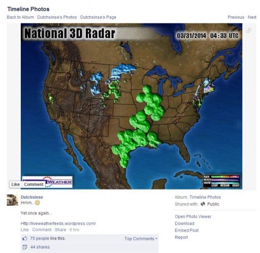
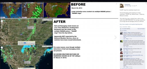
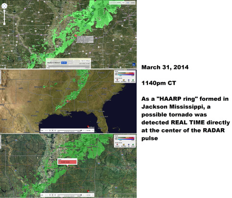
from the first time that biological returns on radar was explained to him. He doesn't understand the pretty pictures he sees, so anything that looks odd to him is a "haarp ring" and any skeptic is a "shill" screaming "birds and bugs".
 
Dutch's juvenile take on a recent grasshopper/beetle swarm out of North Texas:


The article him and his buddy Tatoot are ripping apart:

http://thescoopblog.dallasnews.com/...g-up-on-north-texas-weather-radar-today.html/

I guess he doesn't realize that things such as gust fronts and lake breezes show up on radar. To be clear, the radar imagery he is using is unrelated to the grasshopper swarm. He chose not to use any radar imagery of that event but instead focuses on a northwest Texas thunderstorm.

One of his visitors even got the right answer, but instead she just dismisses it. Somehow the idea of what Dutch is seeing being an outflow boundary is less plausible to her than the idea of man made weather:

comment 3 august 15.JPG

A simple explanation of outflow boundaries and why they often appear on Doppler radar:

http://www.theweatherprediction.com/habyhints/146/

and another video put out by the NWS the week prior:


Dutch just simply cannot get past the whole birds and bugs thing being the ONLY explanation offered up for any radar anomaly and then when there is an event where that IS the explanation he makes a mockery of it. And nowhere in any official press releases was it stated that the grasshoppers were being detected at an altitude of 15,000 feet. But because Dutch uses that figure in his spoof video, his fans now think that was the official explanation from the NWS.
 
I saw the bugs on radar the other day. Was looking at a south regional mosaic loop and say the green areas in Texas. So I pulled the 24hr loop from the individual NEXRAD near Abilene. I immediately thought, bugs, lots of bugs. It was small targets over a huge area moving generally with the very light wind. In the long loop I saw clusters of targets drifting along convergent boundaries as well as a neat looking hole in the returns where a small t-shower collapsed and the downdraft and outflow boundary dispersed the targets. My fun was spoiled knowing how certain people would interpret the event.
 
Some nice AP out of ILX and particularly LOT today starting at around 1300z. I'd guess it's biological. Think Dutch will pick up on it?

efba120ef122833dafe2c545f97ba424.gif
A lot of it looks like it's in the riverine areas around Danville and Kankakee.
 
Last edited:
Some nice AP out of ILX and particularly LOT today starting at around 1300z. I'd guess it's biological. Think Dutch will pick up on it?

efba120ef122833dafe2c545f97ba424.gif
A lot of it looks like it's in the riverine areas around Danville and Kankakee.

ILX often displays reflectivity values from nearby wind farms. It also occasionally has a rather prominent "spike" at about the 277 degree radial from a nearby 4G cell tower.
 
Some nice AP out of ILX and particularly LOT today starting at around 1300z. I'd guess it's biological. Think Dutch will pick up on it?

A lot of it looks like it's in the riverine areas around Danville and Kankakee.

Those are wind farms. I took a look at the loop and the returns were stationary over wind farms I've identified in the past.

http://en.openei.org/wiki/Map_of_Wind_Farms

Dutch seems more focused on earthquakes these days.
 
It is migration season again and here is a timely article on scientists advancing the use of weather surveillance radar as a means of better understanding of the huge largely invisible seasonal event.

http://journals.plos.org/plosone/article?id=10.1371/journal.pone.0160106


Innovative Visualizations Shed Light on Avian Nocturnal Migration


Abstract
Content from External Source

Globally, billions of flying animals undergo seasonal migrations, many of which occur at night. The temporal and spatial scales at which migrations occur and our inability to directly observe these nocturnal movements makes monitoring and characterizing this critical period in migratory animals’ life cycles difficult. Remote sensing, therefore, has played an important role in our understanding of large-scale nocturnal bird migrations. Weather surveillance radar networks in Europe and North America have great potential for long-term low-cost monitoring of bird migration at scales that have previously been impossible to achieve. Such long-term monitoring, however, poses a number of challenges for the ornithological and ecological communities: how does one take advantage of this vast data resource, integrate information across multiple sensors and large spatial and temporal scales, and visually represent the data for interpretation and dissemination, considering the dynamic nature of migration? We assembled an interdisciplinary team of ecologists, meteorologists, computer scientists, and graphic designers to develop two different flow visualizations, which are interactive and open source, in order to create novel representations of broad-front nocturnal bird migration to address a primary impediment to long-term, large-scale nocturnal migration monitoring. We have applied these visualization techniques to mass bird migration events recorded by two different weather surveillance radar networks covering regions in Europe and North America. These applications show the flexibility and portability of such an approach. The visualizations provide an intuitive representation of the scale and dynamics of these complex systems, are easily accessible for a broad interest group, and are biologically insightful. Additionally, they facilitate fundamental ecological research, conservation, mitigation of human–wildlife conflicts, improvement of meteorological products, and public outreach, education, and engagement.
Content from External Source
 
Back
Top