Oroville Dam Spillway Failure

Status
Not open for further replies.

Mick West

Administrator
Staff member
Moderator Note - deirdre
A page of quick access links from within this thread can be found at:
https://www.metabunk.org/oroville-dam-spillway-thread-quick-links.t8416/


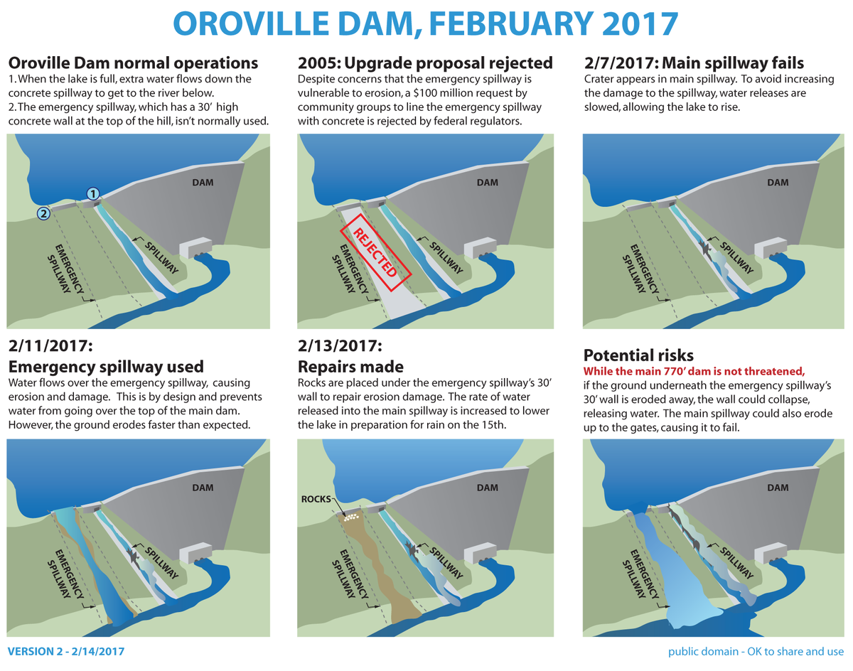
Source: https://commons.wikimedia.org/wiki/File:Oroville_dam_infographic_feb_14.png

UPDATE 2/14/17 - Evacuation order lifted.


UPDATE 4:50PM 2/12/17
Officials Warn of possible collapse of the emergency spillway. Evacuations ordered
http://www.sacbee.com/news/state/california/water-and-drought/article132332499.html

Officials are warning those living downstream of Lake Oroville’s dam to evacuate because of a risk the dam’s emergency spillway could collapse.

“They have what they expect to be an imminent failure of the axillary spillway,” said Mike Smith, a spokesman for the California Department of Forestry and Fire Protection. “What they’re expecting is as much as 30 vertical feet of the top of the spillway could fail and could fail within one to two hours. We don’t know how much water that means, but we do know that’s potentially 30 feet of depth of Lake Oroville.”

The Department of Water Resources, which operates the dam, urged said at around 4:45 the emergency to fail within the next hour. Oroville residents evacuate northward.
Content from External Source

----------------------------------------------------------------------------------------------------

oroville-why-no-collapse-metabunk.jpg
(The above explains why the dam will not collapse. The emergency spillway might collapse, but is separated from the dam itself)

20170208-154520-wpffl.jpg
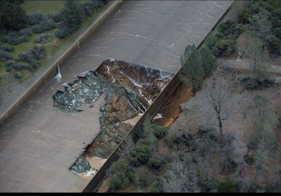
Source: http://pixel-ca-dwr.photoshelter.co...yfg/G00003YCcmDTx48Y/Oroville-Spillway-Damage

On Feb 8th 2017, the spillway of the Oroville dam in Northern California failed after a 150ft wide hole formed and significant amount of the underlying hillside were washed away. The large hole forced operators to shut off the flow at a time when the level of water is rising at unprecedented rates. Currently (Feb 9th) the inflow is 130,000 cubic feet per second, and at the time of the failure the spillway was releasing 50,000 cubic feet per second.

A significant function of dams in California is flood control. If the dam were not there, then the full 130,000 cubic feet per second would be heading down the Feather river through Oroville, Yuba City, and Sacramento. Many areas along the way are behind levees.

If, as seems quite likely, they cannot quickly repair the spillway then they are faced with a difficult choice. They can either continue to let more water flow down it in a controlled manner, which will cause far more damage to the spillway, or they can let the level of water rise until it goes over the emergency spillway (just visible on the left of the above image).

Neither option is good. More damage to the spillway will mean very expensive and time consuming repairs, but using the emergency spillway will be uncontrolled, with the possibility of levees being breached downstream. There will also be very significant local erosion, with the greatest risk being that this leads to the failure of the emergency spillway itself.

The spillway is essentially a lower dam, to the Northwest of the main spillway. It is designed to be overtopped before the dam is.

The worst case would be if the emergency spillway (which was built in the 1960s and has never been used) starts to erode - potentially leading to the formation of a deeper channel allowing for a rapid uncontrolled outflow from the dam.

Oroville Dam Spillway2.jpg

The dam itself would not fail, however a failure of the emergency spillway would lead to some flooding, and significant rebuilding costs. Even the use of the emergency spillway intact would likely mean some downstream flooding if there's a sustained storm. This is referred to in the FERC filings as "loss of crest control"


Update 2/9/2017: Significant changes overnight with a limited test release. The damage is going in the wrong direction.


Update Feb 11 2017:
At around 8:00 AM on Feb 11, the water started to flow over the emergency spillway:
20170211-082549-w1ey5.jpg

Links:
Related Threads:
 
Last edited by a moderator:
The current status is that they are going to re-open the spillway at 20,000 cfs. Run it four hours, and then see how much bigger the hole is.

They also have a hydroelectric plant that's outletting 13,000 cfs, plus 4,000 from a "fish bypass valve" at the bottom of the dam.

Current inflow is 83,000 cfs.

They anticipate eroding away the entire bottom half of the spillway over the season.

There's going to be increasing media coverage of this. Inevitable there will be fears stoke about the dam collapsing, which isn't really a possibility.


Real-time data here:
http://cdec.water.ca.gov/cgi-progs/queryF?s=ORO
 
Last edited:
The current status is that they are going to re-open the spillway at 20,000 cfs. Run it four hours, and then see how much bigger the hole is.

Here is some video of them doing that. Pretty intense. You can clearly see the erosion taking place. The dam is nearing capacity and with another strong storm tomorrow and more storms expected already in the 10day forecast and only half way through the rainy season this could get interesting.

 
Looking at the mid-Jan storms shows how rapidly the level will rise.

http://cdec.water.ca.gov/cdecapp/resapp/resDetailOrig.action?resid=ORO
20170209-084518-8zf7c.jpg


The outlook in the catchment area (I'm using Nelson's Crossing as a representative point) is a couple of inches of rain today, then 4-5 days off before the next storm system. Rainfall is likely to be higher in some regions/altitudes, and possible there will be some snowmelt involved. Basically the inflow is remaining very high for the foreseeable future.
20170209-085227-z1dou.jpg
 
Here is a picture that gives some perspective on the actual size of the hole

OVSpillway.jpg


It has gotten bigger overnight from their test

 
Some perspective on cost - a similar sized (but much less steep) spillway on the smaller Folsom Lake cost $900M and took ten years. I'd imagine though that the larger fraction of that was in the upper end with the connection to the dam and the gates. Still, we are probably looking at the hundred million dollar range here as a minimum.


http://www.mtdemocrat.com/news/folsom-dams-new-spillway-almost-done/

Costing around $900 million so far with a budget cap of $1 billion, the federal government is picking up roughly 50 percent of the tab, the state 32 percent and the Sacramento Area Flood Control Agency 18 percent.

Kegel said they expect to test the spillway gates in December through February and anticipate being finished by October 2017, if not earlier.
Content from External Source
 
So it looks like the damage is proceeding UP the spillway, the lower portion being somewhat protected by the bedrock. This is bad, especially as that was just a limited four hour test at a low release rate.
I know you said there is basically no chance of the dam being breached, but if the erosion is proceeding up the spillway at that rate, could it not get dangerously close to the side of the dam itself?
 
I know you said there is basically no chance of the dam being breached, but if the erosion is proceeding up the spillway at that rate, could it not get dangerously close to the side of the dam itself?

I think the natural geology and terrain was chosen to prevent that happening. Worst case (assuming no major design flaws or undiscovered geology problems) is erosion up towards the power lines, then they would likely use the emergency spillway
20170209-103311-ev86i.jpg
 
Some people are comparing this to the 1976 Teton Dam failure. It's nothing like that. The Teton dam failed because of bad design, and geological factors that were not correctly dealt with. The Teton failure was in the dam itself, and did not start in the spillway. The Oroville spillway (and the emergency spillway) are sufficiently far from the actual dam to avoid any damage to the dam, no matter how uncontrolled the spillway releases become.

The following images are of the Teton dam failure, again the spillway failure is nothing at all like this, and will not lead to this.
https://en.wikipedia.org/wiki/Teton_Dam
20170209-121643-gboo0.jpg
20170209-121603-ijk73.jpg
 
Last edited:
So the current plan from CA-DWR is to run 35,000 cfs down the spillway, and hope the head-cutting (uphill erosion) does not keep going. They are now running it continuously.

Engineers are fairly confident that the head-cutting will reach bedrock at some point, and they will be able to continue to use the main spillway, destroying only the lower 50% or so.
 
Conspriacy theories starting:
http://www.godlikeproductions.com/forum1/message3447337/pg1
I strongly suspect it was destroyed by a bomb by communists and subversives in California's government. I find it extremely odd that this enormous water resource has been crippled right when it could save California agriculture after an extended and proven fabricated drought, which absent the draining of the dams on purpose would have meant nothing. It is proven that the dams were drained in the name of giving tons of water to a fictitious fish called the "delta smelt", which was an invasive species dropped in the Sacramento River delta by settlers 100 years ago. It does not belong there anyway, so saying it is endangered is pure fiction, and nothing but an excuse to destroy California. A textbook communist tactic.
Content from External Source
We'll see more nonsense speculation like this when the story gets picked up by the national press. Mostly the current bunk is of the form "the dam is going to fail".
 
A worst case scenario being suggested is the emergency spillway itself eroding. and this erosion making it's way over to the dam, which would then fail.
20170209-140000-z0ifp.jpg

However it looks to me as if there is bedrock between the spillways and the dam. Indeed the head of the main spillway seems to be set deep within the rock.
20170209-150739-q8vaw.jpg
The above, and this photo from 1968 appears to show the main spillway is cut through rock.
20170209-143931-udnj0.jpg
 
Last edited:
Something I've seen a few times is the suggestion that there's no rebar in the concrete, and this is an indication of shoddy construction, corruption, etc. However it seems to be from looking at images of the 200 foot wide spillway from a distance, where 1" rebar would be invisible. Like this:


If we zoom in though, you can see the shape of the rebar lattice in the concrete and some lengths of rebar.

20170209-155830-xt8p7.jpg

And a close-up of that area reveals the actual rebar swept downstream.
20170209-155604-2mqdd.jpg
 
Last edited:
Friday morning, starting to get light. Outflow has been bumped to 65K cfs for the last four hours, massive damage to the lower spillway will be likely.
20170210-073049-oqm34.jpg

Inflows are declining, to 145K cfs and falling
20170210-072928-7g2a5.jpg

They are not falling rapidly enough though, water levels are seven feet from the emergency spillway
20170210-070405-2n8ju.jpg
(Data source: http://cdec.water.ca.gov/cgi-progs/queryF?s=ORO )

Just some light rain expected for the rest of the day, but there was some solid rain overnight.

Looks like DWR are trying to hold off the emergency spillway as long as possible, as the increase to 65K was a risky move.

I expect this to be big news today, as we are going to have some spectacular photos coming in. There's already a story in the Daily Mail.
http://www.dailymail.co.uk/news/art...st-dam-Lake-Oroville-damaged-amid-storms.html

Inevitably this will lead to apocalyptic stories about dam failure (the integrity of the dam is unrelated to the spillway, as it's round the corner, behind a lot of rock). Expect conspiracy theories, and political exploitation regarding infrastructure investment and departmental authority.
 
Last edited:
If you do some extrapolation on the graphs it actually seems like there's a chance they might avoid the emergency spillway usage if they keep at 65K out. Depends if the inflows continue to decrease (which will also slow the level rise). Inflows set to match outflows at 23:00 (11 PM).

These are all just very rough extrapolations though.

20170210-074647-g6lmi.jpg
 
Thanks for the updates. If I'm reading the topography right on Google Earth, there's at least one electricity pylon in danger if the emergency spillway overtops...
 
Meanwhile, Shasta Lake as of noon was 8.66 feet from the top. Releases are 38,000 CFS, only 55% of maximum, with 104,000 CFS coming in, but they will probably have to increase releases to the maximum by tomorrow morning. I could foresee a flooding problem in Sacramento if this is combined with extraordinary flows from Oroville in the next few days. However, agencies don't seem to be overly concerned.
 
Meanwhile, Shasta Lake as of noon was 8.66 feet from the top. Releases are 38,000 CFS, only 55% of maximum, with 104,000 CFS coming in, but they will probably have to increase releases to the maximum by tomorrow morning. I could foresee a flooding problem in Sacramento if this is combined with extraordinary flows from Oroville in the next few days. However, agencies don't seem to be overly concerned.

The Oroville flows are not that extraordinary, they would probably be letting out more if they did not have this problem.

Locally Folsom releases are 80,000 CFS for inflow 127,000. Level is 447 feet out of 466, rising about 0.4 feet per hour (about 10 ft per day) probably not an issue with five days of sun ahead. Lots of roads out though as everything is saturated and there's landslides.
http://cdec.water.ca.gov/cgi-progs/queryF?s=FOL

Sacramento IS flooding in the riverside parks and suchlike. Next storm might be a problem. Too soon to tell.
 
The conspiracy theorists, trolls and whatnot are coming out into the YouTube comments of the various news videos covering this incident. I am linking directly to the videos in question below. I will add that I think the AP headline is irresponsible, as it does not make it clear that the hole is in the spillway.

Fears Over Oroville Dam Spillway Grow As Hole Gets Larger


Source: https://www.youtube.com/watch?v=Y4erbPyYbmc


[The powers that be had their collective thumb up their ass and were falsely convinced the drought was going to last forever and nothing needed to be done. The state's been spending money hand over fist for years on stupid pet projects to line pockets and "combat" imaginary boogeymen in the distant future. Meanwhile very real inevitabilities get ignored and stuff like this happens. It's utterly mind boggling how bass-ackwards California is.
Content from External Source
As a side note, similar claims surfaced in Australia following the Queensland floods in 2010/11.

200-Foot-Long Hole in Damaged Calif. Dam (Associated Press)


Source: https://www.youtube.com/watch?v=T595rAtZH20


Turning it back on is what blew out the side,wall, before that it was a 30 hour fix max. I've worked for Halliburton before, I worked with blow outs before. And I assure you, They didn't turn it off so the can work to access the problem, They stared at it and looked at each other and said, Well, now what? Well, lets turn the water back on and maybe it will go away. These so called managers that with any brains at all should of been doing monthly inspections year round. Yes, they may have degree's But they have no experience. No common sense, No plan B even. And that is simply stupidity. Now, there plan is to release water in the all out emergency spillway, If you want to call it that, Did you know that's never even been tested?. The failed spillway is coming apart and that's concrete. The emergency one will just erode right up the side of the mountain. Now, it doesn't take a person with tons of real on hands experience to figure out there's a major problem. If that was the case average people wouldn't be so worried about it, And I assure you, you have a reason to worry. I said there was going to be a problem this year, I big flood,, I said it a month ago. I have it saved to. What's going to dome this is the snow melt hasn't even started yet and were hours from a full Dam and a broken UN-inspected spillway. OH, They may says its inspected, Do you think it was? That's probably what there doing in the back office right now, Printing out fake inspection sheets possibly. I pray am wrong, I wouldn't want to see trillions in damage and loss of life. If you have life jackets out in the garage get em ready. If i had kids up there they'd be wearing them to bed. My only question would be to the experts, If its not in anyways a major threat, Just why did you feel the need to shut all the schools down then?
Content from External Source
 
Turning it back on is what blew out the side,wall, before that it was a 30 hour fix max.
Content from External Source
Armchair engineering. If they attempt a 30 hour fix (very unlikely timeframe if you look at the size of the hole, the terrain and access road) then you've also got to gamble that it holds, while you've also got a lake that's now very close to overflowing, so you'd have to push 100K cfs down something you just slapped to together with no testing or meaningful inspections.

With hindsight they could probably have had better inspections, as always.
 
To: Mick West

Tonight, on KRCR news (Redding, CA), Jerry Olinen, reported that in 2013 the Oroville Dam spillway had a problem (break in the concrete) in the same exact area where the hole started on Tuesday. Jerry posted pictures of several white DWR trucks that were parked on the spillway in 2013 during inspection and repairs. Jerry asked DWR 'Chief' engineer today, why this problem area wasn't inspected more thoroughly (was it preventable?)...Only visual inspections were done in 2015. The Chief engineer responded that "we didn't think we had a problem...". Really?

This is awful, and no one but the Feds should be liable for paying for the fix. Right? Help me understand?


[link added:
"Obviously something has happened that we didn't expect to happen," said Kevin Dossey, a senior engineer with the Department of Water Resources. "I don't think anybody who is in the inspection team or the repair team would say that more should have been done because there wasn't more evidence that more needed to be done."

2013 photo_1486774392447_5834027_ver1.0_640_360.jpg

http://www.krcrtv.com/news/local/bu...mage-surfaces-supervisor-blames-dwr/325934917
Content from External Source
 
and no one but the Feds should be liable for paying for the fix. Right?

why should the Feds be liable?

Any repairs or problems at Oroville Dam are paid for by the 29 urban and agricultural water contractors that buy water from the State Water Project, which include the Metropolitan Water District of Southern California, Kern County Water Agency, Santa Clara Valley Water District and others. These contractors, in turn, pass along their costs to ratepayers, including homeowners, business owners or farmers.

Read more here: http://www.sacbee.com/news/local/environment/article2584322.html#storylink=cpy
Content from External Source
 
Looking at the photo at the top of #18, it looks possible that the softer brown material eroded away from underneath the spillway, becoming semiliquified as the soil saturated with water. This would create a void where the spillway was not supported from underneath, leading to the failure.
 
Now at 899.16 of 901 feet, still rising around .25 feet or so per hour. The had to reduce the flow, and it has been raining a bit. Going to be really close. If it's going to overtop then it will probably be sometime Saturday morning.
20170210-231846-beqr2.jpg
 
This is from yesterday.
20170211-073627-gjku8.jpg

Notice the freshly concreted rocks at the bottom. A quick fix, and shows the very real concern of damage to the emegency spillway. If that gets undercut there's a BIG problem
 
Last edited:
Status
Not open for further replies.
Back
Top