deirdre
Senior Member.
Oroville thread links:
---main thread-----------------
https://www.metabunk.org/oroville-dam-spillway-failure.t8381/page-15#post-200495
--waterfall erosion (main spillway)
https://www.metabunk.org/oroville-dam-main-spillway-waterfall-erosion-watch.t8402/
--current weather, lake levels etc
https://www.metabunk.org/oroville-w...el-and-inflow-calculations.t8406/#post-200737
--spillway wall drain system
https://www.metabunk.org/oroville-dam-drains-in-the-spillway-walls-how-do-they-work.t8407/
Event Timeline:
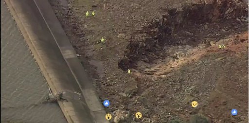
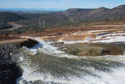
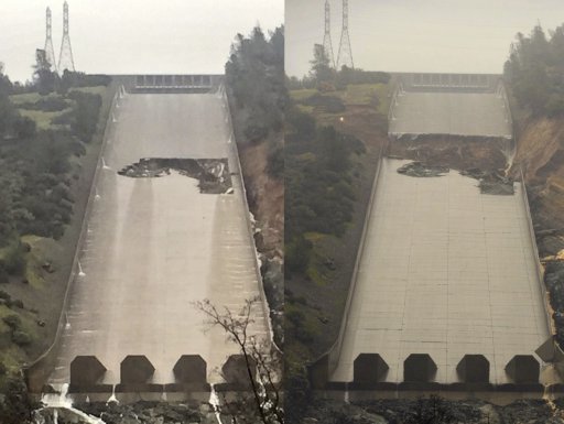
Feb 7 hole forms in spillway
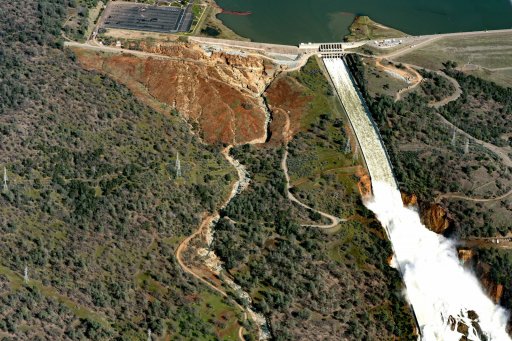
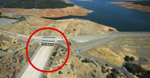
Feb 11 water breaches emergency spillway
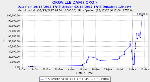
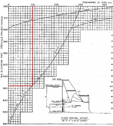
Feb 12 evacuation ordered and main spillway turned on (100,000 cfs)
Feb 14 evacuation reduced to evacuation warning
-----------------------------------------------
Memorandum report March 17 FERC
https://www.metabunk.org/oroville-dam-spillway-failure.t8381/page-38#post-203671
FROM MAIN THREAD:
------------------------------------------------------
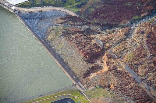
DWR photos
http://pixel-ca-dwr.photoshelter.co...yfg/G00003YCcmDTx48Y/Oroville-Spillway-Damage
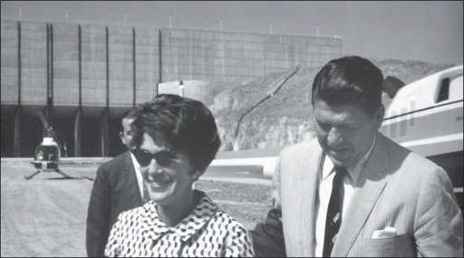
There are multiple galleries on the left, the above pic is from the Dedication 1968 gallery.
http://pixel-ca-dwr.photoshelter.com/galleries/C0000OxvlgXg3yfg/G0000_XF0AkosxZI/Dedication-1968
DWR Twitter
https://twitter.com/CA_DWR/media
The Lake Oroville web cam gives a live look at the level of the lake:
https://www.parks.ca.gov/?page_id=29411
Links to some Dam inspection reports (down left side of article)
http://www.chicoer.com/article/NA/20170210/NEWS/170219971
Dam original blueprints etc
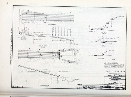
https://archive.org/stream/zh9californiastatew2003calirich#page/96/mode/2up
or
https://ia800302.us.archive.org/3/i...lirich/zh9californiastatew2003calirich_bw.pdf
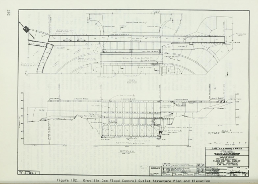
Blueprints top of spillway
https://archive.org/stream/august11975orovi20378cali#page/292/mode/2up
Early models of spillways, erosion testing, hydraulic models etc
https://www.usbr.gov/tsc/techreferences/hydraulics_lab/pubs/HYD/HYD-510.pdf
https://www.usbr.gov/tsc/techreferences/hydraulics_lab/pubs/HYD/HYD-507.pdf
https://www.usbr.gov/tsc/techreferences/hydraulics_lab/pubs/HYD/HYD-508.pdf
https://www.usbr.gov/tsc/techreferences/hydraulics_lab/pubs/HYD/HYD-502.pdf
https://en.wikipedia.org/wiki/2017_Oroville_Dam_crisis
Some folks interested in sublimation and snowmelt may find interest in this NOAA site.
http://www.nohrsc.noaa.gov/interact...2017&em=2&ed=19&eh=6&data=0&units=0®ion=us
a VERY general Dam Maintence pdf (oklahoma) guide, erosion etc for laymen
https://www.owrb.ok.gov/hazard/dam/pdf_dam/DamMaintenanceGuidelines.pdf
---------------------------------------------------------
---------------------------------------------------------
Page 1 (February 8)
Real-time data here:
http://cdec.water.ca.gov/cgi-progs/queryF?s=ORO
Long range forecast models are showing another round of significant storms starting next Thursday with 2 possible 3 more AR [Atmospheric River] events training into CA.
http://weather.rap.ucar.edu/model/displayMod.php?var=gfs_sfc_prcp&loop=loopall&hours=
-------------------------------------------------------------
Page 2 (weir calculations)
The edges of these puddles will give a good indication of the changes in the lake level.
Source: https://www.youtube.com/watch?v=RpTSUHDM2JQ
http://www.codecogs.com/library/engineering/fluid_mechanics/weirs/discharge.php
------------------------------------------------------------
Page 3 (February 11)
Drone footage February 11
Source: https://www.youtube.com/watch?v=bephol1Ormg
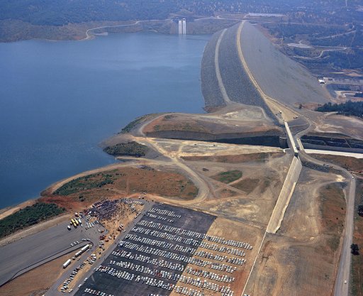
History and historical photos of Oroville dam
http://www.petersoncat.com/history/oroville-dam
Very interesting lawsuit from 2005 arguing for the need for the emergency (auxiliary) spillway to have a lined chute:
https://elibrary.ferc.gov/idmws/com...).pdf&folder=19973004&fileid=10849040&trial=1
aerial footage 2/11
Source: https://www.youtube.com/watch?v=bCK1FSKfPwU
More on why the generators are shut off
http://www.krcrtv.com/news/breaking-news/dwr-holds-press-conference-about-oroville-dam/327843952
------------------------------------------------------------
Page 4 (february 12)
start of evacuation order
https://www.facebook.com/bcsonews/posts/781255845358029
http://www.sacbee.com/news/state/california/water-and-drought/article132332499.html
*DWR increasing main spillway to 100,000 cfs
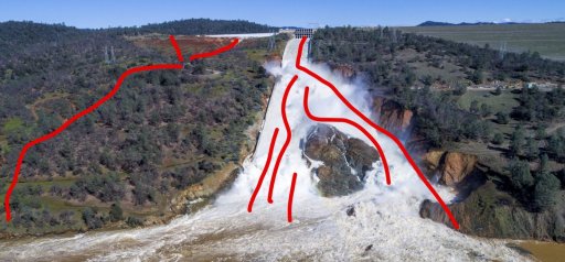
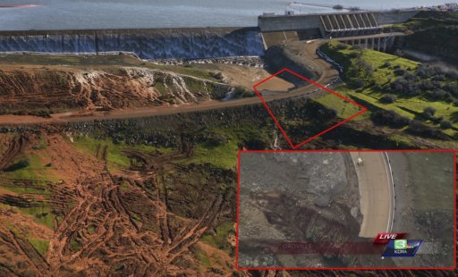
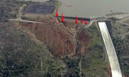
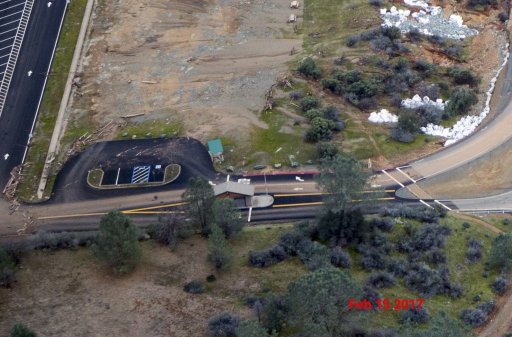
Parking lot was flooded last night, the problem is the erosion below the weir:
Live pic from a few minutes ago:
http://www.krcrtv.com/krcr-news-channel-7-live-stream
*start of bags of rock work/helicopters
-------------------------------------------------------------
Page 5
Geology of Oroville
https://www.geocaching.com/geocache/GC1BZ9C_table-mountain-basalt
https://archive.org/stream/geologyoforovill00creerich/geologyoforovill00creerich_djvu.txt
*first talk of possibility of weir failing/ "boil" spotted
----------------------------------------------------------
page 6 (February 13)
geological data
https://www.metabunk.org/oroville-dam-spillway-failure.t8381/page-6#post-199975
"The accelerographs are located on the dam, which is located on rocks of the upper Paleozoic 'Bedrock Series'; dense and usually massive metavolcanic schists. The maximum thickness for these rocks in this area is 1500m."
https://pubs.usgs.gov/of/1978/1005/report.pdf
One of the references describes the Bedrock Series on page 77, but without details of the dam site.
https://archive.org/details/geologyoforovill00creerich
"I found a map in this report (which you may have all already seen) with the various levee tolerances. (Fig 4 of report)."
http://frrfmp.com/wp-content/uploads/2013/05/FRFMPDraft5.14.13.pdf
Graphic of state flood plan
https://www.metabunk.org/oroville-dam-spillway-failure.t8381/page-6#post-200014
-----------------------------------------------------------
Page 7
re: possible erosion
For comparison, one of the fastest moving waterfalls is Niagara Falls, which is 187 feet high and has moved seven miles in 12,500 years (3 feet per year).
https://www.niagaraparks.com/about-niagara-falls/geology-facts-figures.html
I think by "boil" they just mean a pocket of high energy water where it's hitting an obstruction and bouncing around, like in a whitewater situation.
http://www.pinnacle-travel.org/whitewater-rafting-glossary/
http://www.russellfork.info/descrgorge.htm
--------------------------------------------------------
Page 8
--------------------------------------------------------
Page 9
**helicopter etc con't to repair emergency spillway
There's an "Army Corps of Engineers Oroville Dam Reservoir Regulation Manual" mentioned here:
https://elibrary.ferc.gov/idmws/com...).pdf&folder=19973004&fileid=10849040&trial=1
But I have been unable to find a copy.
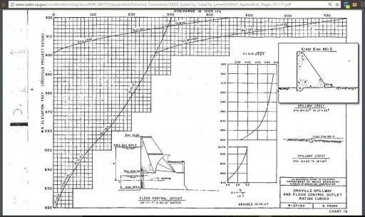
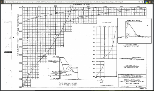
A lot of the original design specification, blueprints, and operating rules are here
http://www.water.ca.gov/orovillerelicensing/docs/FEIR_080722/AppendixA/Extracted_Comments/C0005_SutterCty_YubaCity_Levee Dst1_Appendices_Pages_10-177.pdf
*weir data linked, csf specs linked
------------------
**2005 relicensing debate
But in this FERC filing, note the text that is missing from the above.
https://elibrary.ferc.gov/idmws/com...).pdf&folder=19973004&fileid=10849040&trial=1
Interesting difference in quotes here: (re: FERC relicensing suit)
http://yubariver.org/wp-content/upl...g_Oroville-auxiliary-spillway-major-risks.pdf
“It is important to recognize that during a rare event with the emergency spillway flowing at its design capacity, spillway operations would not affect reservoir control or endanger the dam,” wrote John Onderdonk, a senior civil engineer with FERC, in the Federal Energy Regulatory Commission’s San Francisco Office, in a July 27, 2006, memo to his managers.
“The emergency spillway meets FERC’s engineering guidelines for an emergency spillway,” he added. “The guidelines specify that during a rare flood event, it is acceptable for the emergency spillway to sustain significant damage.”
http://www.mercurynews.com/2017/02/...tate-officials-ignored-warnings-12-years-ago/
------------------
----------------------------------------------------------
Page 10
shasta talk
pics of erosion
feb 10th-feb13th comparison shots
https://www.metabunk.org/oroville-dam-spillway-failure.t8381/page-10#post-200207
*geology chat
http://www.water.ca.gov/orovillerelicensing/docs/DEIR_070521/06 Ch 04 Env Setting Part 1.pdf
Source: https://www.youtube.com/watch?v=g1sR9vuBYp4
Source: https://www.youtube.com/watch?v=p_5udzKfLQM
-----------------------------------------------------------
Page 11
*quad d9
This Says the valves were rated at 2,400 CFS max (but should have been lower for safety). It's not clear if that is per valve. There were six valves.
https://www.dir.ca.gov/dosh/citations/CA Water Resources 313228637Summary.pdf
2/14 repair work from neighbor
Source: https://www.youtube.com/watch?v=ux9MSHoVL2g
-----------------------------------------------------------
page 12 (February 14)
drone video february 13th
Source: https://www.youtube.com/watch?v=VBP-4ah3U6s
Yesterday's KCRA livestream of the damage and the rocks drops is archive on Facebook. Nothing new really, but a good set of overview shots.
https://www.facebook.com/KCRA3/videos/10155029133956514/?permPage=1
*Yuba city flood data
video people walking in spillway
Source: https://www.youtube.com/watch?v=XZO_744b_Gs
-------------------------------------------------------------
page 14
specs on another spillway that failed due to drains
http://www.rjh-consultants.com/site...e_Spillway-Catastrophic_Failure_Prevented.pdf
Source: https://www.youtube.com/watch?v=ahOEdiYj8z8#t=18m0s
--------------------------------------------------------------
page 15 (February 15)
Ralph, I don't believe the venturi effect is a good analogy for the current situation (nor is it for an airplane wing...see NASA explanation here https://www.grc.nasa.gov/WWW/K-12/airplane/bernnew.html)
A few comments from an ex-geologist and poli sci person, now retired from both, who has been following this since the beginning (thanks, Mick for this site!) .
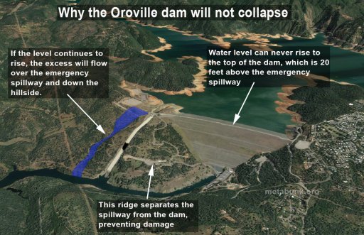
The press didn't pick up on it, but in one of the press conferences (I believe it was the very 'upbeat' one shortly before the declaration of emergency) Acting Director Croyle said 'the purpose of the emergency spillway is to save the dam'. It was never intended to be a secondary source of water release with the first spillway damaged.
From a geology point of view, as I look at the various photos and such, it seems clear they sited the dam proper and the main spillway on the best bedrock they could. I imagine they put the emergency spillway in the best spot they could given the geology, but I'm not surprised the rock there is less competent than what's under the main spillway
https://www.metabunk.org/oroville-dam-spillway-failure.t8381/page-15#post-200455
Source: https://www.youtube.com/watch?v=5DUA46Xm-Jk
https://www.ferc.gov/industries/hydropower/safety/guidelines/fema-94.pdf
*DWR using both 'emergency' and 'auxilliary' to describe weir/emergency spillway
http://hyperphysics.phy-astr.gsu.edu/hbase/pber.html#bcal
-----------------------------------------------------------
Page 16
https://youtu.be/E0Rzi8kELM4
Could this be the trigger for the lower portion of main spillway crumbling?
http://www.johnmartin.com/earthquakes/eqpapers/00000052.htm
http://www.water.ca.gov/orovillerel...baCity_Levee Dst1_Appendices_Pages_10-177.pdf
(Page 107, "Oroville Spillway and Flood Control Outlet Rating Curves" 1963)
------------------------------------------------------
Page 17
It appears that there's no flow through the generators. https://cdec.water.ca.gov/cgi-progs/queryF?ORO is showing 99.9kCFS outflow, and 117.6 river release, how's that possible?
*parkinglot weir chat and "sacrificial plug" theory chat
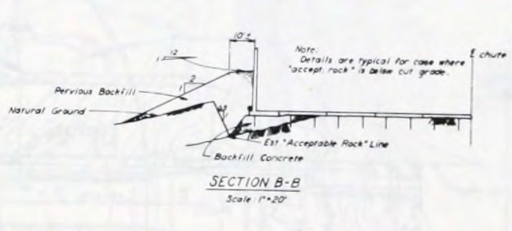
"In part of the emergency spillway, an additional 10 feet of excavation was required to reach acceptable foundation rock, resulting in considerable additional time for excavation and placement of the backfill concrete to subgrade"
Page 133 of https://ia800302.us.archive.org/3/i...lirich/zh9californiastatew2003calirich_bw.pdf
The "weir" there is about 1' high, a bit of road going over one bit of it isn't going to do anything.
https://www.metabunk.org/oroville-dam-spillway-failure.t8381/page-17#post-200630
Beck, J. L. "Weight-induced stresses and the recent seismicity at Lake Oroville, California." Bulletin of the Seismological Society of America 66.4 (1976): 1121-1131.
-----------------------------------------------------------
page 18
https://www.youtube.com/watch?v=Y00wUYTuD4s
pics of other emergency spillway to dam examples
https://www.metabunk.org/oroville-dam-spillway-failure.t8381/page-18#post-200690
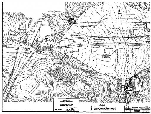
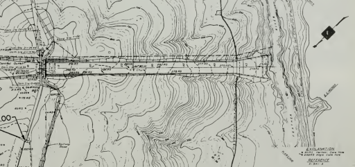
Looking at https://archive.org/details/zh9californiastatew2003calirich and judging from the general plan (Pg 94/92):
https://www.metabunk.org/oroville-dam-spillway-failure.t8381/page-18#post-200698
Go to http://www.historicaerials.com/ and search for Oroville dam. Look at the 1973 topo or newer to orient yourself and then drop to 1966 and earlier.
-----------------------------------------------------------
Page 19 (February 16)
You might 'enjoy' reading this discussion of the St. Francis Dam failure. It touches on geology, dam physics, hydraulic forces, etc.
http://web.mst.edu/~rogersda/st_francis_dam/reassessment_of_st_francis_dam_failure.pdf
And other articles at http://web.mst.edu/~rogersda/st_francis_dam/
Interesting current standard practices:
https://policy.nrcs.usda.gov/OpenNonWebContent.aspx?content=32418.wba
Video of the Area around the parking lot while the weir was beng overtopped
https://www.facebook.com/cecilejuliette/videos/1278569305556763/
If anyone outside California wants a quick visual primer on the geology here is a University of California public lecture that covers a lot of history and possible future scenarios for California plate tectonics. https://www.youtube.com/watch?v=DcSma09I08A&t=1693s
It's from here.
https://mng-chico.smugmug.com/Oroville-Week-of-5-9-2016/i-FJMxJTc/A
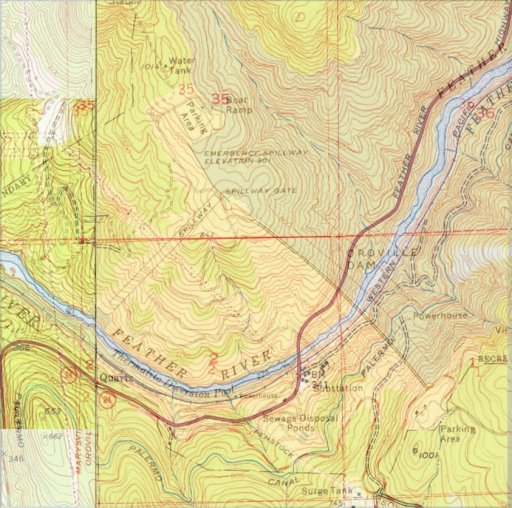
Historic USGS topographic map
https://ngmdb.usgs.gov/img4/ht_icons/Browse/CA/CA_Bidwell Bar_288362_1950_24000.jpg
https://ngmdb.usgs.gov/img4/ht_icons/Browse/CA/CA_Oroville Dam_293795_1970_24000.jpg
--------------------------------------------------------------
page 20
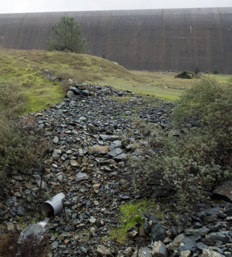
A relief well discharge pipe perhaps?
The possible explanation is around the 28:00 minute mark.
https://www.youtube.com/watch?v=AhpMyq4ZV2k
Those were both emergency spillways in addition to the normal spillways
https://en.wikipedia.org/wiki/New_Don_Pedro_Dam
https://www.metabunk.org/oroville-dam-spillway-failure.t8381/page-20#post-200868
-----------------------------------------------------------
Page 21
https://archive.org/stream/august11975orovi20378cali#page/292/mode/2up
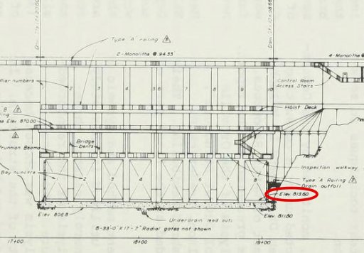
Found a blueprint of the top of the spillway. It shows the starting monolith#20 of the emergency dam and also the approach wall you are talking about in the photo.
Regarding the discussion in previous posts about venturi effects contributing to the cause of the service spillway failure, a Google search using the words "spillway floor slab jacking Reclamation" returns this link:
https://www.usbr.gov/ssle/damsafety/risk/BestPractices/Chapters/VI-1-20150610.pdf
Reference 3 in this link: "Bureau of Reclamation, Uplift and Crack Flow Resulting from High Velocity Discharges over Open Offset Joints, Report DSO-07-07, Technical Service Center, Denver CO, December 2007" provides derivation of equations based on venturi principles, predictions using the equations, and results from large-scale laboratory experiments that verify the predictions. Modern construction has rubber or copper "water stops" incorporated in all joints between floor slabs, which should prevent this from happening, but the water stops can fail if the offset is too great.
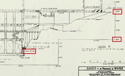
Because it's the bottom of the intake cut that matters, at 813.6 feet.
https://archive.org/stream/august11975orovi20378cali#page/292/mode/2up
https://www.metabunk.org/oroville-dam-spillway-failure.t8381/page-21#post-200957
----------------------
More on concrete slab control joints from the American Concrete Paving Association.
http://www.acpa.org/wp-content/uplo...oint-Design-and-Construction-FINAL-100214.pdf
A concrete slab WILL crack as it cures, no matter the reinforcing within. The trick is to control the cracking to locations that are planned, and design for load transfer between the now independent slabs with dowel bars.
https://www.fhwa.dot.gov/pavement/concrete/pubs/07021/07021.pdf
These joints are sealed to retard water infiltration, and is a continuous maintenance issue on concrete paved highways.
http://wikipave.org/index.php?title=Joint_Sealing
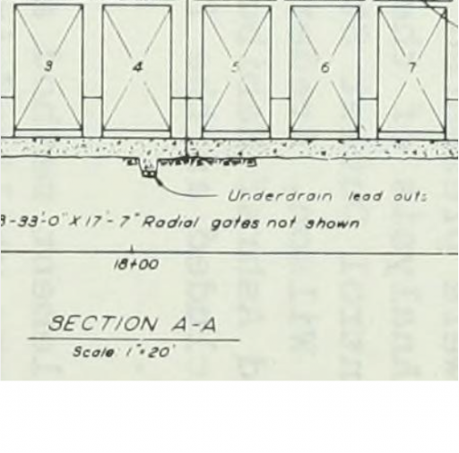
Re the drainage under the concrete spillway and the weir, I ran across the following (cross posted in the spillway erosion thread ):
Pages 133/134 of https://ia800302.us.archive.org/3/i...lirich/zh9californiastatew2003calirich_bw.pdf
pg 146 of 546 is an overall plan drawing of the spillway with contours. pg 148 is an elevation with typical sections. Haven't found any drawings detailing the drainage system yet.
https://ia800302.us.archive.org/3/i...lirich/zh9californiastatew2003calirich_bw.pdf
---------------------------------------------------------
Page 22
https://www.youtube.com/watch?v=0NJYyUKb0mA
post #847
Cavitation is easy to analyze and relatively cheap to fix. The responsible CA DWR engineers or administrators should be [fired] if they cannot produce a spillway cavitation analysis or proof that they added some aeration to the flow as it is well-studied and well known problem. We could ballpark a cavitation analysis.
https://www.usbr.gov/ssle/damsafety/risk/BestPractices/Chapters/VI-3-20150610.pdf
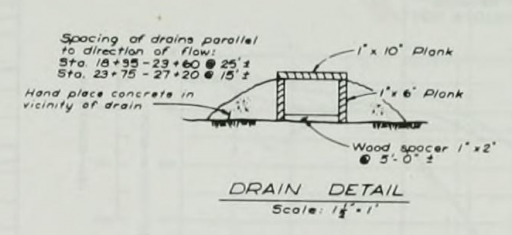
Detail of the e-spillway drain from https://archive.org/stream/zh9californiastatew2003calirich#page/96/mode/2up
https://www.youtube.com/watch?v=j8DYb_3XPF4
From the spillway design description, from page 100 of https://archive.org/stream/zh9californiastatew2003calirich
-------------------------------------------------
Page 23 (February 17)
new flow ravine forming near bottom of spillway
---------------------------------------------------
Page 24
core samples (post #929)
Document page 94 (pg 146 of 546 in the .pdf)
https://ia800302.us.archive.org/3/i...3calirich/zh9californiastatew2003calirich.pdf
post #932 bunch of close up detail shots of slabs (spillway collapsed)
https://archive.org/stream/august11975orovi20378cali#page/292/mode/2up
Don't know if this is the start of the underground pipe system but since it's at the spillway gate floor it might be (Pg282)
big pipes debunk post #954
---------------------------------------------------
Page 25 (February 18)
Here is an interesting 3d dwg of the area.
https://sketchfab.com/models/a2e069b5196945b79d9487c2730cbcac
http://www.water.ca.gov/orovillerelicensing/docs/app_ferc_license_2005/Vol_IV_App B_Project Description.pdf
Pg 18 routine mainenance
-------------------------------------------------
Page 26 (February 18th)
https://www.usbr.gov/tsc/techreferences/hydraulics_lab/pubs/HYD/HYD-507.pdf
https://www.usbr.gov/tsc/techreferences/hydraulics_lab/pubs/HYD/HYD-508.pdf
https://www.usbr.gov/tsc/techreferences/hydraulics_lab/pubs/HYD/HYD-502.pdf
https://archive.org/stream/zh9californiastatew2003calirich#page/96/mode/2up
Pg 96 Here is a blueprint of the emerg. spillway. I don't know if this is already posted but I thought I would post. Please delete if already posted previously.
American Concrete Institute paper on concrete failure due to cavitation. Includes photos and examples of dam spillways. This link is to the downloadable PDF file
https://www.google.com/url?sa=t&sou...gguMAQ&usg=AFQjCNFadpI0GTvOG7vK7vxt_pAChZrS1g
California State Flood Plan
http://www.water.ca.gov/cvfmp/docs/DRAFT_SPFC_Descriptive_Doc_20100115.pdf
Lake level last 2 years (chart)
https://www.metabunk.org/oroville-dam-spillway-failure.t8381/page-26#post-201368
Current update 2/18/17 16:00 PST:
Level: 854.07 (drop of 48.51 feet from peak)
Acre feet in reservoir: 2,863,316
Inflow: 38,343
Outflow: 54,987 (They have now reduced outflow to 55,000 cfs)
Reservoir Capacity: 3,573,577
Current available storage: 711,261 Acre feet
http://cdec.water.ca.gov/cgi-progs/queryF?s=ORO&d=18-Feb-2017+16:15&span=150hours
-------------------------------------------------------------------------------
page 27
reservoir levels since 1995 (chart)
https://www.metabunk.org/oroville-dam-spillway-failure.t8381/page-27#post-201393
geologic survey decade before dam built
https://www.metabunk.org/oroville-dam-spillway-failure.t8381/page-27#post-201406
-------------------------------------------------------------------------------
page 28 (February 18)
chat about repair work
--------------------------------------------------------------------------------
page 29 (February 19)
explanation of workers fired for posting pics to social media
https://www.metabunk.org/oroville-dam-spillway-failure.t8381/page-29#post-201521
There's also a mention in one of the documents that the last edit[300' 30'] section of the ogee weir is variable in height and width. The first section closest to the spillway is solid and massive, but the second section further out is obviously tapered to shorter/narrower sections until it ends at the parking lot weir. edit: [Sorry - I'll try to find a reference. California State Water Project Vol. III Storage Facilities Bulletin 200 November 1974 Fig. 79 Pg. 97]
more geology chat
From the 1974 Storage Facilities report, page 67:
Page 30
Flooding in California is a ongoing interest for many, the FLood Plain Management Assoc., for example. http://www.floodplain.org/sacramento
They did use the right term, however the word "boil" has multiple meanings. Consider one of the original Oroville dam studies
https://www.usbr.gov/tsc/techreferences/hydraulics_lab/pubs/HYD/HYD-510.pdf
PDF Page 48-49, Document page 37
https://www.metabunk.org/oroville-dam-spillway-failure.t8381/page-30#post-201617
FERC scan of orders to DWR to hie Board of independant contractors
https://www.ferc.gov/media/statements-speeches/lafleur/2017/P-2100-02-13-2017.pdf
-----------------------------------------------------------------------------
page 31
NOTE: Thank you to @David Larson for all your help gathering links.
---main thread-----------------
https://www.metabunk.org/oroville-dam-spillway-failure.t8381/page-15#post-200495
--waterfall erosion (main spillway)
https://www.metabunk.org/oroville-dam-main-spillway-waterfall-erosion-watch.t8402/
--current weather, lake levels etc
https://www.metabunk.org/oroville-w...el-and-inflow-calculations.t8406/#post-200737
--spillway wall drain system
https://www.metabunk.org/oroville-dam-drains-in-the-spillway-walls-how-do-they-work.t8407/
Event Timeline:
Feb 7 hole forms in spillway
Feb 11 water breaches emergency spillway
Feb 12 evacuation ordered and main spillway turned on (100,000 cfs)
Feb 14 evacuation reduced to evacuation warning
-----------------------------------------------
Memorandum report March 17 FERC
https://www.metabunk.org/oroville-dam-spillway-failure.t8381/page-38#post-203671
FROM MAIN THREAD:
------------------------------------------------------
DWR photos
http://pixel-ca-dwr.photoshelter.co...yfg/G00003YCcmDTx48Y/Oroville-Spillway-Damage
There are multiple galleries on the left, the above pic is from the Dedication 1968 gallery.
http://pixel-ca-dwr.photoshelter.com/galleries/C0000OxvlgXg3yfg/G0000_XF0AkosxZI/Dedication-1968
DWR Twitter
https://twitter.com/CA_DWR/media
The Lake Oroville web cam gives a live look at the level of the lake:
https://www.parks.ca.gov/?page_id=29411
Links to some Dam inspection reports (down left side of article)
http://www.chicoer.com/article/NA/20170210/NEWS/170219971
Dam original blueprints etc
https://archive.org/stream/zh9californiastatew2003calirich#page/96/mode/2up
or
https://ia800302.us.archive.org/3/i...lirich/zh9californiastatew2003calirich_bw.pdf
Blueprints top of spillway
https://archive.org/stream/august11975orovi20378cali#page/292/mode/2up
Early models of spillways, erosion testing, hydraulic models etc
https://www.usbr.gov/tsc/techreferences/hydraulics_lab/pubs/HYD/HYD-510.pdf
https://www.usbr.gov/tsc/techreferences/hydraulics_lab/pubs/HYD/HYD-507.pdf
https://www.usbr.gov/tsc/techreferences/hydraulics_lab/pubs/HYD/HYD-508.pdf
https://www.usbr.gov/tsc/techreferences/hydraulics_lab/pubs/HYD/HYD-502.pdf
https://en.wikipedia.org/wiki/2017_Oroville_Dam_crisis
Some folks interested in sublimation and snowmelt may find interest in this NOAA site.
http://www.nohrsc.noaa.gov/interact...2017&em=2&ed=19&eh=6&data=0&units=0®ion=us
a VERY general Dam Maintence pdf (oklahoma) guide, erosion etc for laymen
https://www.owrb.ok.gov/hazard/dam/pdf_dam/DamMaintenanceGuidelines.pdf
---------------------------------------------------------
---------------------------------------------------------
Page 1 (February 8)
Real-time data here:
http://cdec.water.ca.gov/cgi-progs/queryF?s=ORO
Long range forecast models are showing another round of significant storms starting next Thursday with 2 possible 3 more AR [Atmospheric River] events training into CA.
http://weather.rap.ucar.edu/model/displayMod.php?var=gfs_sfc_prcp&loop=loopall&hours=
-------------------------------------------------------------
Page 2 (weir calculations)
The edges of these puddles will give a good indication of the changes in the lake level.
Source: https://www.youtube.com/watch?v=RpTSUHDM2JQ
http://www.codecogs.com/library/engineering/fluid_mechanics/weirs/discharge.php
------------------------------------------------------------
Page 3 (February 11)
Drone footage February 11
Source: https://www.youtube.com/watch?v=bephol1Ormg
History and historical photos of Oroville dam
http://www.petersoncat.com/history/oroville-dam
Very interesting lawsuit from 2005 arguing for the need for the emergency (auxiliary) spillway to have a lined chute:
https://elibrary.ferc.gov/idmws/com...).pdf&folder=19973004&fileid=10849040&trial=1
aerial footage 2/11
Source: https://www.youtube.com/watch?v=bCK1FSKfPwU
More on why the generators are shut off
http://www.krcrtv.com/news/breaking-news/dwr-holds-press-conference-about-oroville-dam/327843952
------------------------------------------------------------
Page 4 (february 12)
start of evacuation order
https://www.facebook.com/bcsonews/posts/781255845358029
http://www.sacbee.com/news/state/california/water-and-drought/article132332499.html
*DWR increasing main spillway to 100,000 cfs
Parking lot was flooded last night, the problem is the erosion below the weir:
Live pic from a few minutes ago:
http://www.krcrtv.com/krcr-news-channel-7-live-stream
*start of bags of rock work/helicopters
-------------------------------------------------------------
Page 5
Geology of Oroville
https://www.geocaching.com/geocache/GC1BZ9C_table-mountain-basalt
https://archive.org/stream/geologyoforovill00creerich/geologyoforovill00creerich_djvu.txt
*first talk of possibility of weir failing/ "boil" spotted
----------------------------------------------------------
page 6 (February 13)
geological data
https://www.metabunk.org/oroville-dam-spillway-failure.t8381/page-6#post-199975
"The accelerographs are located on the dam, which is located on rocks of the upper Paleozoic 'Bedrock Series'; dense and usually massive metavolcanic schists. The maximum thickness for these rocks in this area is 1500m."
https://pubs.usgs.gov/of/1978/1005/report.pdf
One of the references describes the Bedrock Series on page 77, but without details of the dam site.
https://archive.org/details/geologyoforovill00creerich
"I found a map in this report (which you may have all already seen) with the various levee tolerances. (Fig 4 of report)."
http://frrfmp.com/wp-content/uploads/2013/05/FRFMPDraft5.14.13.pdf
Graphic of state flood plan
https://www.metabunk.org/oroville-dam-spillway-failure.t8381/page-6#post-200014
-----------------------------------------------------------
Page 7
re: possible erosion
For comparison, one of the fastest moving waterfalls is Niagara Falls, which is 187 feet high and has moved seven miles in 12,500 years (3 feet per year).
https://www.niagaraparks.com/about-niagara-falls/geology-facts-figures.html
I think by "boil" they just mean a pocket of high energy water where it's hitting an obstruction and bouncing around, like in a whitewater situation.
http://www.pinnacle-travel.org/whitewater-rafting-glossary/
http://www.russellfork.info/descrgorge.htm
--------------------------------------------------------
Page 8
--------------------------------------------------------
Page 9
**helicopter etc con't to repair emergency spillway
There's an "Army Corps of Engineers Oroville Dam Reservoir Regulation Manual" mentioned here:
https://elibrary.ferc.gov/idmws/com...).pdf&folder=19973004&fileid=10849040&trial=1
But I have been unable to find a copy.
A lot of the original design specification, blueprints, and operating rules are here
http://www.water.ca.gov/orovillerelicensing/docs/FEIR_080722/AppendixA/Extracted_Comments/C0005_SutterCty_YubaCity_Levee Dst1_Appendices_Pages_10-177.pdf
*weir data linked, csf specs linked
------------------
**2005 relicensing debate
But in this FERC filing, note the text that is missing from the above.
https://elibrary.ferc.gov/idmws/com...).pdf&folder=19973004&fileid=10849040&trial=1
Interesting difference in quotes here: (re: FERC relicensing suit)
http://yubariver.org/wp-content/upl...g_Oroville-auxiliary-spillway-major-risks.pdf
“It is important to recognize that during a rare event with the emergency spillway flowing at its design capacity, spillway operations would not affect reservoir control or endanger the dam,” wrote John Onderdonk, a senior civil engineer with FERC, in the Federal Energy Regulatory Commission’s San Francisco Office, in a July 27, 2006, memo to his managers.
“The emergency spillway meets FERC’s engineering guidelines for an emergency spillway,” he added. “The guidelines specify that during a rare flood event, it is acceptable for the emergency spillway to sustain significant damage.”
http://www.mercurynews.com/2017/02/...tate-officials-ignored-warnings-12-years-ago/
------------------
----------------------------------------------------------
Page 10
shasta talk
pics of erosion
feb 10th-feb13th comparison shots
https://www.metabunk.org/oroville-dam-spillway-failure.t8381/page-10#post-200207
*geology chat
http://www.water.ca.gov/orovillerelicensing/docs/DEIR_070521/06 Ch 04 Env Setting Part 1.pdf
Source: https://www.youtube.com/watch?v=g1sR9vuBYp4
Source: https://www.youtube.com/watch?v=p_5udzKfLQM
-----------------------------------------------------------
Page 11
*quad d9
This Says the valves were rated at 2,400 CFS max (but should have been lower for safety). It's not clear if that is per valve. There were six valves.
https://www.dir.ca.gov/dosh/citations/CA Water Resources 313228637Summary.pdf
2/14 repair work from neighbor
Source: https://www.youtube.com/watch?v=ux9MSHoVL2g
-----------------------------------------------------------
page 12 (February 14)
drone video february 13th
Source: https://www.youtube.com/watch?v=VBP-4ah3U6s
Yesterday's KCRA livestream of the damage and the rocks drops is archive on Facebook. Nothing new really, but a good set of overview shots.
https://www.facebook.com/KCRA3/videos/10155029133956514/?permPage=1
*Yuba city flood data
video people walking in spillway
Source: https://www.youtube.com/watch?v=XZO_744b_Gs
-------------------------------------------------------------
page 14
specs on another spillway that failed due to drains
http://www.rjh-consultants.com/site...e_Spillway-Catastrophic_Failure_Prevented.pdf
Source: https://www.youtube.com/watch?v=ahOEdiYj8z8#t=18m0s
--------------------------------------------------------------
page 15 (February 15)
Ralph, I don't believe the venturi effect is a good analogy for the current situation (nor is it for an airplane wing...see NASA explanation here https://www.grc.nasa.gov/WWW/K-12/airplane/bernnew.html)
A few comments from an ex-geologist and poli sci person, now retired from both, who has been following this since the beginning (thanks, Mick for this site!) .
The press didn't pick up on it, but in one of the press conferences (I believe it was the very 'upbeat' one shortly before the declaration of emergency) Acting Director Croyle said 'the purpose of the emergency spillway is to save the dam'. It was never intended to be a secondary source of water release with the first spillway damaged.
From a geology point of view, as I look at the various photos and such, it seems clear they sited the dam proper and the main spillway on the best bedrock they could. I imagine they put the emergency spillway in the best spot they could given the geology, but I'm not surprised the rock there is less competent than what's under the main spillway
https://www.metabunk.org/oroville-dam-spillway-failure.t8381/page-15#post-200455
Source: https://www.youtube.com/watch?v=5DUA46Xm-Jk
https://www.ferc.gov/industries/hydropower/safety/guidelines/fema-94.pdf
*DWR using both 'emergency' and 'auxilliary' to describe weir/emergency spillway
http://hyperphysics.phy-astr.gsu.edu/hbase/pber.html#bcal
-----------------------------------------------------------
Page 16
https://youtu.be/E0Rzi8kELM4
Could this be the trigger for the lower portion of main spillway crumbling?
http://www.johnmartin.com/earthquakes/eqpapers/00000052.htm
http://www.water.ca.gov/orovillerel...baCity_Levee Dst1_Appendices_Pages_10-177.pdf
(Page 107, "Oroville Spillway and Flood Control Outlet Rating Curves" 1963)
------------------------------------------------------
Page 17
It appears that there's no flow through the generators. https://cdec.water.ca.gov/cgi-progs/queryF?ORO is showing 99.9kCFS outflow, and 117.6 river release, how's that possible?
*parkinglot weir chat and "sacrificial plug" theory chat
"In part of the emergency spillway, an additional 10 feet of excavation was required to reach acceptable foundation rock, resulting in considerable additional time for excavation and placement of the backfill concrete to subgrade"
Page 133 of https://ia800302.us.archive.org/3/i...lirich/zh9californiastatew2003calirich_bw.pdf
The "weir" there is about 1' high, a bit of road going over one bit of it isn't going to do anything.
https://www.metabunk.org/oroville-dam-spillway-failure.t8381/page-17#post-200630
Beck, J. L. "Weight-induced stresses and the recent seismicity at Lake Oroville, California." Bulletin of the Seismological Society of America 66.4 (1976): 1121-1131.
-----------------------------------------------------------
page 18
https://www.youtube.com/watch?v=Y00wUYTuD4s
pics of other emergency spillway to dam examples
https://www.metabunk.org/oroville-dam-spillway-failure.t8381/page-18#post-200690
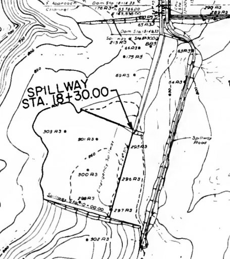
Looking at https://archive.org/details/zh9californiastatew2003calirich and judging from the general plan (Pg 94/92):
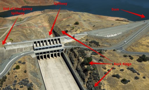
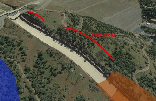
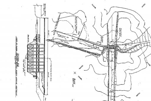
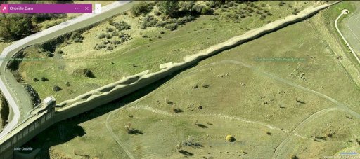
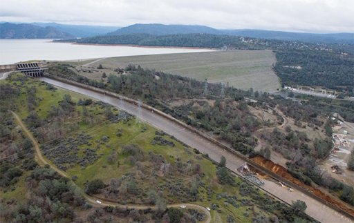
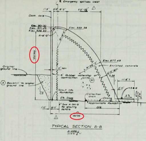
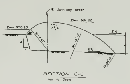
Also, here's the parking lot weir sectionThe emergency spillway is an ungated, concrete, overpour weir located to the right of the flood control outlet and is made up of two sections ( Figure 79) . The right 800-foot section is a broad-crested weir on a bench excavation. The left 930-foot section is a gravity ogee weir up to 50 feet in height. Except for a narrow strip immediately downstream of the weir, the terrain below the weir was not cleared of trees and other natural growth because emergency spillway use will be infrequent
https://www.metabunk.org/oroville-dam-spillway-failure.t8381/page-18#post-200698
Go to http://www.historicaerials.com/ and search for Oroville dam. Look at the 1973 topo or newer to orient yourself and then drop to 1966 and earlier.
-----------------------------------------------------------
Page 19 (February 16)
You might 'enjoy' reading this discussion of the St. Francis Dam failure. It touches on geology, dam physics, hydraulic forces, etc.
http://web.mst.edu/~rogersda/st_francis_dam/reassessment_of_st_francis_dam_failure.pdf
And other articles at http://web.mst.edu/~rogersda/st_francis_dam/
Interesting current standard practices:
https://policy.nrcs.usda.gov/OpenNonWebContent.aspx?content=32418.wba
https://www.metabunk.org/oroville-dam-spillway-failure.t8381/page-19#post-2007657) Preparing rock foundations Blasting may be required to remove rock to the specified depth. This is often required in dam construction to slope a steep abutment or excavate a core trench into a rock abutment. Blasting may be employed to excavate an auxiliary spillway in a rock abutment. Care must be taken to avoid over-blasting and damage to rock below the specified lower limit of excavation. Blasting is a dangerous operation and should only be performed by experienced contractors who have the required license for handling and using explosives. See section 645.0701(c) for more on blasting.
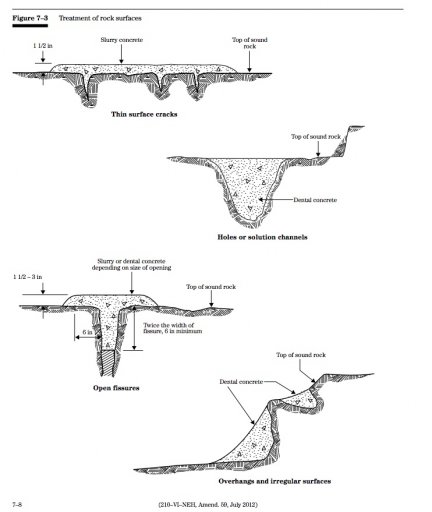
Rock foundations must be cleaned to permit bonding with the materials to be placed. Earth, loose rock, and loose, weathered material should be removed from the surface and from any cracks or crevices. Washing and brooming may be necessary, particularly in locations where concrete is to be placed. Overhanging rock should be removed or the volume beneath the overhanging rock filled with dental concrete so that all materials can be placed on a positive slope (fig 7–3). Dental concrete is used to fill holes and to contour surfaces. Slurry concrete is used to fill clean cracks and crevices in rock. Rock, such as shale, that can break down when exposed should be left covered or protected from the elements until just before being covered with earthfill, concrete, or other construction materials.
Grouting is often required to fill subsurface voids in the foundation. The location and depth of subsurface grouting should be detailed on the drawings and in the specifications. Each location may present a distinct problem, and modifications may be required as the work progresses. Where subsurface grouting is required, a geologist should assist in verifying the adequacy of and recommending deviations from the specified location, depth, and treatment.
The performance of the completed structure is often reflected in the thoroughness with which procedures for preparing rock foundations are undertaken. This is particularly true for any dam or dike designed to retain water. Few dams are constructed without finding some undesirable foundation conditions that were not discovered in the geologic investigation for design. Most discrepancies between design and field construction occur in this portion of the work. The inspector must be aware of undesirable foundation conditions and be especially vigilant during this phase of the work
Video of the Area around the parking lot while the weir was beng overtopped
https://www.facebook.com/cecilejuliette/videos/1278569305556763/
If anyone outside California wants a quick visual primer on the geology here is a University of California public lecture that covers a lot of history and possible future scenarios for California plate tectonics. https://www.youtube.com/watch?v=DcSma09I08A&t=1693s
It's from here.
https://mng-chico.smugmug.com/Oroville-Week-of-5-9-2016/i-FJMxJTc/A
Historic USGS topographic map
https://ngmdb.usgs.gov/img4/ht_icons/Browse/CA/CA_Bidwell Bar_288362_1950_24000.jpg
https://ngmdb.usgs.gov/img4/ht_icons/Browse/CA/CA_Oroville Dam_293795_1970_24000.jpg
--------------------------------------------------------------
page 20
A relief well discharge pipe perhaps?
The possible explanation is around the 28:00 minute mark.
https://www.youtube.com/watch?v=AhpMyq4ZV2k
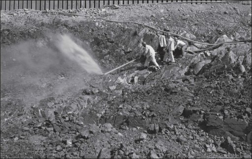
According to Western Construction magazine’s October 1966 issue, “Buster’s Quad D9s were the star of the show on the $20 million spillway. Excavation of some 4 million cubic yards of solid rock made it one of the biggest ripping jobs in the West at the time. One million yards of that material had to be ripped using various methods, including Peterson’s new Quad D9 arrangement, outfitted with two 10-ft shanks, each with 4-ft extensions. The rock was so hard that when points and shanks wore out, they simply replaced rather than rebuilt them. http://www.petersoncat.com/history/oroville-dam
A reply to the Peterson Cat reference:
Be careful with using an industry publication as a factual source. They are justifiably proud that they got in on one of the biggest contracts the state had ever issued, and their audience is the other contractors that they might be able to do business with later, or concurrently for that matter. In this case, their numbers don't add up and are massaged for their benefit. https://www.metabunk.org/oroville-dam-spillway-failure.t8381/page-21#post-200924
Those were both emergency spillways in addition to the normal spillways
https://en.wikipedia.org/wiki/New_Don_Pedro_Dam
https://www.metabunk.org/oroville-dam-spillway-failure.t8381/page-20#post-200868
-----------------------------------------------------------
Page 21
https://archive.org/stream/august11975orovi20378cali#page/292/mode/2up
Found a blueprint of the top of the spillway. It shows the starting monolith#20 of the emergency dam and also the approach wall you are talking about in the photo.
Regarding the discussion in previous posts about venturi effects contributing to the cause of the service spillway failure, a Google search using the words "spillway floor slab jacking Reclamation" returns this link:
https://www.usbr.gov/ssle/damsafety/risk/BestPractices/Chapters/VI-1-20150610.pdf
Reference 3 in this link: "Bureau of Reclamation, Uplift and Crack Flow Resulting from High Velocity Discharges over Open Offset Joints, Report DSO-07-07, Technical Service Center, Denver CO, December 2007" provides derivation of equations based on venturi principles, predictions using the equations, and results from large-scale laboratory experiments that verify the predictions. Modern construction has rubber or copper "water stops" incorporated in all joints between floor slabs, which should prevent this from happening, but the water stops can fail if the offset is too great.
Because it's the bottom of the intake cut that matters, at 813.6 feet.
https://archive.org/stream/august11975orovi20378cali#page/292/mode/2up
https://www.metabunk.org/oroville-dam-spillway-failure.t8381/page-21#post-200957
----------------------
More on concrete slab control joints from the American Concrete Paving Association.
http://www.acpa.org/wp-content/uplo...oint-Design-and-Construction-FINAL-100214.pdf
A concrete slab WILL crack as it cures, no matter the reinforcing within. The trick is to control the cracking to locations that are planned, and design for load transfer between the now independent slabs with dowel bars.
https://www.fhwa.dot.gov/pavement/concrete/pubs/07021/07021.pdf
These joints are sealed to retard water infiltration, and is a continuous maintenance issue on concrete paved highways.
http://wikipave.org/index.php?title=Joint_Sealing
----------------------The purpose of joint sealant is to minimize infiltration of surface water and incompressible material into the joint system [1][2][3]. Sealants also reduce dowel bar corrosion potential by reducing entrance of de-icing chemicals. Pavement engineers have recognized the need for concrete pavement joint sealants for many years. Sealant use dates back to the early 1900's [4][5]. Today, nearly every agency building and maintaining concrete roadways or airports requires joint sealing.?
Re the drainage under the concrete spillway and the weir, I ran across the following (cross posted in the spillway erosion thread ):
Pages 133/134 of https://ia800302.us.archive.org/3/i...lirich/zh9californiastatew2003calirich_bw.pdf
Drain System.
The foundation drains designed for the spillway included nearly vertical NX holes drilled 65 feet into the foundation rock of headworks
Monoliths 25 and 26 and extensive perforated pipe systems on the foundation surface under the headworks, chute, and higher portions of the emergency spillway weir.
Much of the drain system on the foundation surface was modified during construction.
The original 4-inch-diameter, horizontal, pipe drains under the chute were redesigned in accordance with a recommendation from the Oroville Dam Consulting Board.
The pipes were placed on a herringbone pattern to give them a downward slope and enlarged to a 6-inch diameter. The longitudinal collector system was enlarged proportionally and modified slightly. The effect of these modifications was to increase the system's capacity and its self-cleaning ability.
The pipes remained on the foundation enveloped in gravel which projected into the reinforced-concrete floor of the chute.
Similar drain pipes were impractical to place on irregular rock surfaces under the headworks and emergency spillway weir. The contractor was allowed to substitute wooden formed drains of equal cross- 133 sectional area. These forms were cut to fit the irregular rock surface and remained in place after the concrete was placed over them.
pg 146 of 546 is an overall plan drawing of the spillway with contours. pg 148 is an elevation with typical sections. Haven't found any drawings detailing the drainage system yet.
https://ia800302.us.archive.org/3/i...lirich/zh9californiastatew2003calirich_bw.pdf
---------------------------------------------------------
Page 22
https://www.youtube.com/watch?v=0NJYyUKb0mA
post #847
Cavitation is easy to analyze and relatively cheap to fix. The responsible CA DWR engineers or administrators should be [fired] if they cannot produce a spillway cavitation analysis or proof that they added some aeration to the flow as it is well-studied and well known problem. We could ballpark a cavitation analysis.
https://www.usbr.gov/ssle/damsafety/risk/BestPractices/Chapters/VI-3-20150610.pdf
Detail of the e-spillway drain from https://archive.org/stream/zh9californiastatew2003calirich#page/96/mode/2up
https://www.youtube.com/watch?v=j8DYb_3XPF4
From the spillway design description, from page 100 of https://archive.org/stream/zh9californiastatew2003calirich
-------------------------------------------------
Page 23 (February 17)
new flow ravine forming near bottom of spillway
---------------------------------------------------
Page 24
core samples (post #929)
Document page 94 (pg 146 of 546 in the .pdf)
https://ia800302.us.archive.org/3/i...3calirich/zh9californiastatew2003calirich.pdf
post #932 bunch of close up detail shots of slabs (spillway collapsed)
https://archive.org/stream/august11975orovi20378cali#page/292/mode/2up
Don't know if this is the start of the underground pipe system but since it's at the spillway gate floor it might be (Pg282)
big pipes debunk post #954
---------------------------------------------------
Page 25 (February 18)
Here is an interesting 3d dwg of the area.
https://sketchfab.com/models/a2e069b5196945b79d9487c2730cbcac
http://www.water.ca.gov/orovillerelicensing/docs/app_ferc_license_2005/Vol_IV_App B_Project Description.pdf
Pg 18 routine mainenance
-------------------------------------------------
Page 26 (February 18th)
https://www.usbr.gov/tsc/techreferences/hydraulics_lab/pubs/HYD/HYD-507.pdf
https://www.usbr.gov/tsc/techreferences/hydraulics_lab/pubs/HYD/HYD-508.pdf
https://www.usbr.gov/tsc/techreferences/hydraulics_lab/pubs/HYD/HYD-502.pdf
https://archive.org/stream/zh9californiastatew2003calirich#page/96/mode/2up
Pg 96 Here is a blueprint of the emerg. spillway. I don't know if this is already posted but I thought I would post. Please delete if already posted previously.
American Concrete Institute paper on concrete failure due to cavitation. Includes photos and examples of dam spillways. This link is to the downloadable PDF file
https://www.google.com/url?sa=t&sou...gguMAQ&usg=AFQjCNFadpI0GTvOG7vK7vxt_pAChZrS1g
California State Flood Plan
http://www.water.ca.gov/cvfmp/docs/DRAFT_SPFC_Descriptive_Doc_20100115.pdf
Lake level last 2 years (chart)
https://www.metabunk.org/oroville-dam-spillway-failure.t8381/page-26#post-201368
Current update 2/18/17 16:00 PST:
Level: 854.07 (drop of 48.51 feet from peak)
Acre feet in reservoir: 2,863,316
Inflow: 38,343
Outflow: 54,987 (They have now reduced outflow to 55,000 cfs)
Reservoir Capacity: 3,573,577
Current available storage: 711,261 Acre feet
http://cdec.water.ca.gov/cgi-progs/queryF?s=ORO&d=18-Feb-2017+16:15&span=150hours
-------------------------------------------------------------------------------
page 27
reservoir levels since 1995 (chart)
https://www.metabunk.org/oroville-dam-spillway-failure.t8381/page-27#post-201393
geologic survey decade before dam built
https://www.metabunk.org/oroville-dam-spillway-failure.t8381/page-27#post-201406
-------------------------------------------------------------------------------
page 28 (February 18)
chat about repair work
--------------------------------------------------------------------------------
page 29 (February 19)
explanation of workers fired for posting pics to social media
https://www.metabunk.org/oroville-dam-spillway-failure.t8381/page-29#post-201521
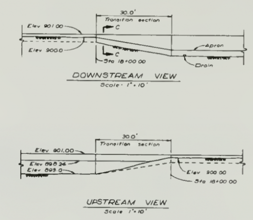
There's also a mention in one of the documents that the last edit[300' 30'] section of the ogee weir is variable in height and width. The first section closest to the spillway is solid and massive, but the second section further out is obviously tapered to shorter/narrower sections until it ends at the parking lot weir. edit: [Sorry - I'll try to find a reference. California State Water Project Vol. III Storage Facilities Bulletin 200 November 1974 Fig. 79 Pg. 97]
more geology chat
From the 1974 Storage Facilities report, page 67:
-----------------------------------------------------------------------------Regional Geology and Seismicity
Oroville Dam lies in the foothills on the western
slope of the Sierra Nevada, a westerly tilted fault
block with a core of granitic rock. A series of tightly
folded, steeply dipping, metamorphic rocks overlies
the granite core along its western and northwestern
flanks.
Page 30
Flooding in California is a ongoing interest for many, the FLood Plain Management Assoc., for example. http://www.floodplain.org/sacramento
They did use the right term, however the word "boil" has multiple meanings. Consider one of the original Oroville dam studies
https://www.usbr.gov/tsc/techreferences/hydraulics_lab/pubs/HYD/HYD-510.pdf
PDF Page 48-49, Document page 37
https://www.metabunk.org/oroville-dam-spillway-failure.t8381/page-30#post-201617
FERC scan of orders to DWR to hie Board of independant contractors
https://www.ferc.gov/media/statements-speeches/lafleur/2017/P-2100-02-13-2017.pdf
-----------------------------------------------------------------------------
page 31
NOTE: Thank you to @David Larson for all your help gathering links.
Last edited:

