Cargo flight KTA1732 lost over Gulf of Oman

Kyle Ferriter

Senior Member.
Flight KTA1732 flown by aircraft with registration AP-BOI has gone missing in the Gulf of Oman after departing Dubai and going east, intending to land in Karachi.

https://www.flightradar24.com/data/aircraft/ap-boi#408bc3bc

FlightRadar24 reports there has been active GPS interference in the area related to the war with Iran, causing difficulty for ADSB aggregators.

External Quote:
...
Preliminary ADS-B data indicate a loss of altitude, followed by a climb, and then a second, sudden and dramatic loss of altitude. The final received data point from the aircraft was at 16:21 UTC, placing the aircraft at 1,100 ft AMSL with a reported vertical rate of -22,400 feet per minute.
...
Shortly after takeoff the aircraft, all others in the region, experienced GNSS interference, resulting in the degraded data near Sharjah and transition to MLAT tracking by Flightradar24. Once the the aircraft exited the area subject to GNSS interference, ADS-B data was once again received by Flightradar24.
...
https://www.flightradar24.com/blog/...major-incident/k2-airways-cargo-737-accident/

There have been multiple US-flown aircraft circling above the Gulf of Oman east of Dubai and the Straight of Hormuz, and ADSB Exchange shows very spotty tracks of civilian planes in that area. Looking back the past week, the US has had one or more large planes flying a holding pattern in the same location at least since 7/1 (that's as far as I looked back right now), so their presence today is not out of the ordinary.
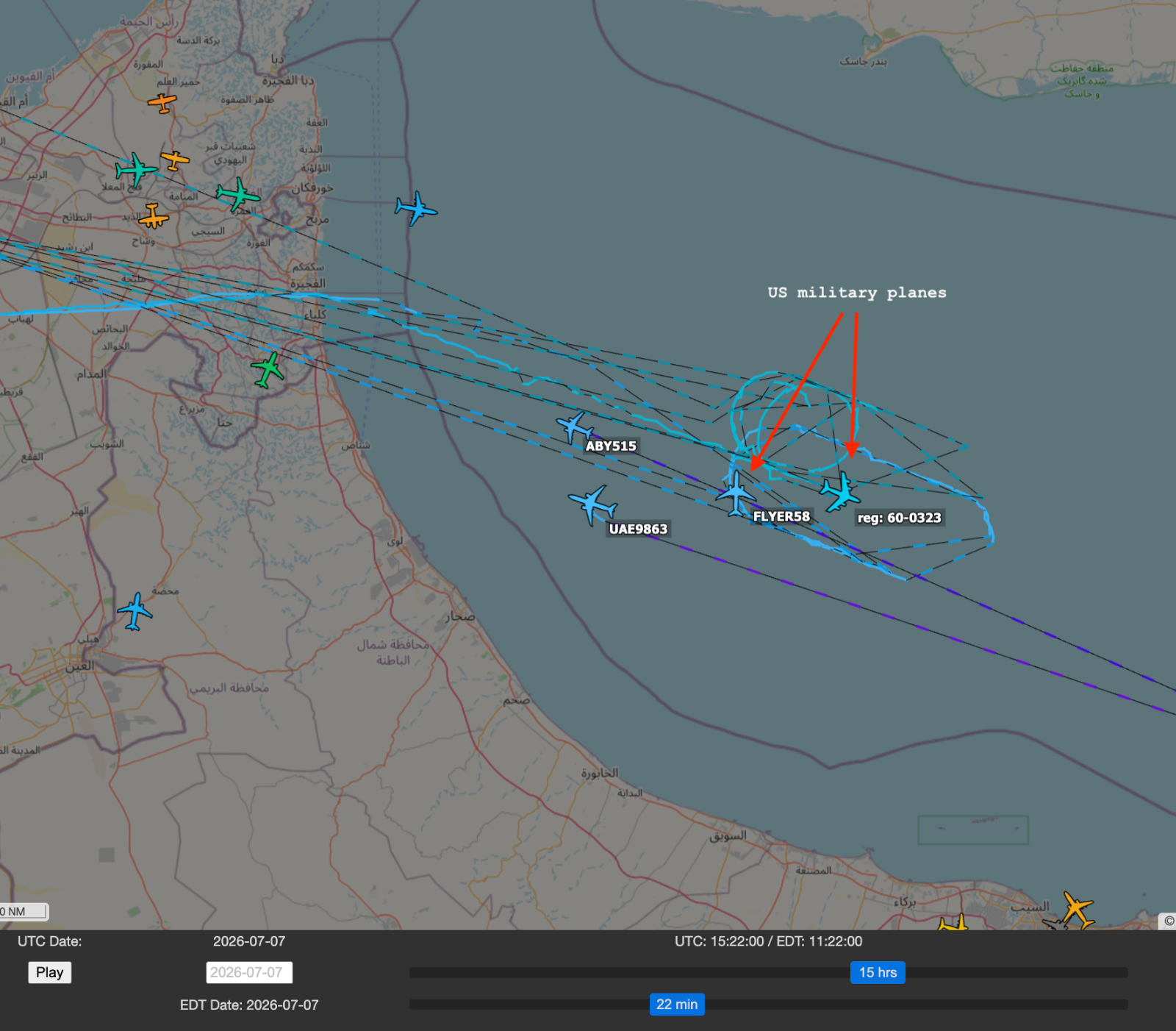
Screenshot 2026-07-07 at 16.23.49 copy.png


FlightRadar24 shows that flight ABY546 which was flying just ahead of KTA1732 on the same route from Sharjah airport (Dubai) to Karachi, did complete its trip.
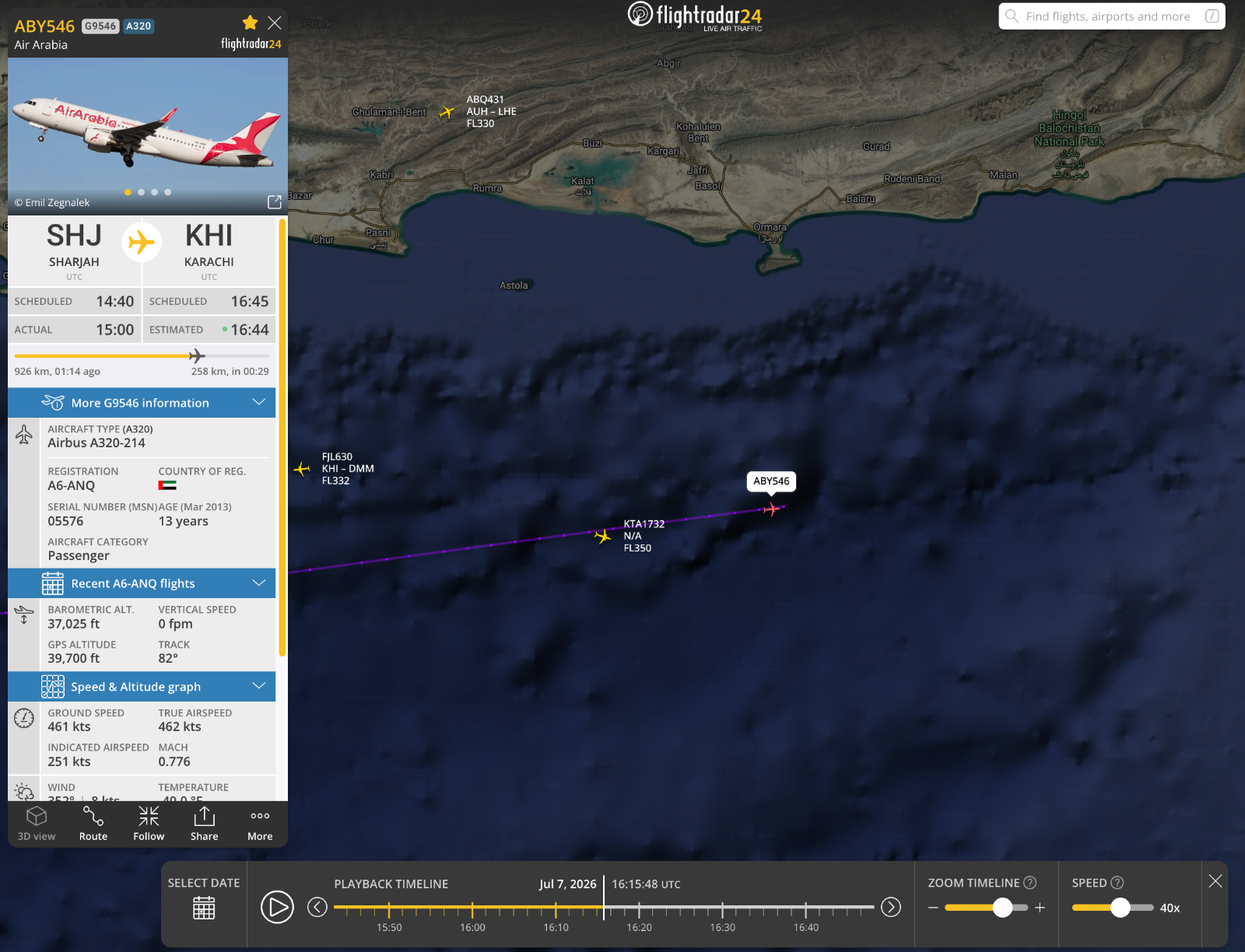
Screenshot 2026-07-07 at 17.43.52.png


I'm not sure where FlightRadar24 is getting their data for these flights or if they have tweaks to enable more interpolation, because ADSB Exchange shows massive gaps in the tracks. Unless FR24 has a lot more feeders in that area than ADSBx does, I'm not sure to what extent specific points along this track are reliable, or how much is extrapolation/interpolation over noisy data. It's possible ADSBx is filtering out some low-quality time points that FR24 is not.

ADSBx's track ends at 2026-07-07 15:53:32 UTC, but FR24 continues to 2026-07-07 16:21:59 UTC, at which point it shows a turn, a brief dip, and then a very rapid decline, after which the track ends.

https://www.metabunk.org/sitrec/?custom=17113/FR24 KTA1732 20260707/20260707_214113.js
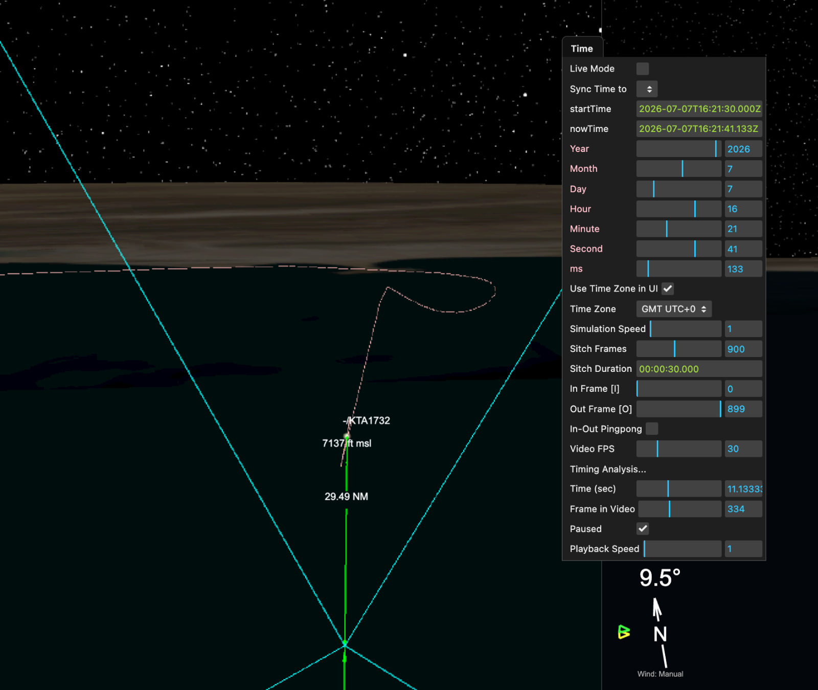
Screenshot 2026-07-07 at 17.32.28.png


FlightRadar24 KML for this flight is attached as 408bc3bc.kml. ADSB Exchange KMLs attached in zip file.
 

Attachments

External Quote:
According to the Pakistan Airports Authority (PAA), the crew reported a navigational system problem to the Karachi Area Control Centre at approximately 9:18 PM Pakistan Standard Time. Air traffic controllers immediately began providing navigational assistance as the aircraft continued toward Karachi. Within about three minutes, radar data showed the Boeing 737 descending rapidly while simultaneously making a significant heading change.
https://simpleflying.com/pakistan-cargo-boeing-737-missing-search-rescue/
 
From a blog post from FlightRadar24 describing how they are now using 3-point MLAT (they previously required 4) to attempt to correct tracks subjected to GPS interference:
External Quote:
By calculating MLAT positions for all flights, Flightradar24 is able to counter the effects of GPS interference in real time and show a more correct path for an aircraft. We recently completed a major update to our MLAT calculations, allowing us to calculate MLAT positions using just three receivers. Previously, four receivers were necessary to calculate positions. This improvement has allowed us to increase the area in which we are able to show MLAT positions, including some of the areas of the world experiencing the greatest amount of GPS jamming and spoofing.

Because of how MLAT positions are calculated, they are not as precise as GPS derived positions. However, as a counter to wild deviations caused by GPS spoofing or jamming, they have become an extremely useful tool for showing accurate flight paths. In May 2025, 7% of flights that are normally tracked via ADS-B were tracked with MLAT due to GPS interference.
https://www.flightradar24.com/blog/...ightradar24-uses-mlat-to-counter-gps-jamming/

This may be how they are able to show a more complete than ADSB Exchange does.
 
FlightAware KML attached. (source: https://www.flightaware.com/live/flight/APBOI/history/20260707/1512Z)

This track ends at 2026-07-07 16:19:51 UTC, which is around the peak of the bump before the rapid descent.

FlightRadar24 has a point in their KML at 16:19:52 UTC. Below is the FlightRadar24 track in Google Earth, with a yellow arrow pointing to 16:19:52 UTC.

Screenshot 2026-07-07 at 18.43.01 copy.png
 

Attachments

https://www.flightradar24.com/blog/...major-incident/k2-airways-cargo-737-accident/ has the altitude/speed diagram, which certainly suggests that the aircraft was fine until it was not.

AP-BOI-Playback-1536x1495.jpg

The speed first spikes as the aircraft descends (same mechanic as on a slide), the pilots then take the aircraft up to altitude but at the cost of speed (same mechanic as on a swing set), but then they seem to lose lift and go down.
This means that either the aircraft suffered an upset and then stalled as the speed got too low, or something structural broke (not just an engine, this is not an engine-out glide).
Or we have a rare suicidal pilot again.

As usual when the aircraft is at the bottom of the ocean, facts are going to be hard to come by. "They collided with a flying saucer" is going to be hard to debunk for a while, US military radar assets notwithstanding ("the government is covering it up"). Maybe they were on a plan where the aircraft regularly sends maintenance data via satellite; then we'd have a source of potentially helpful information. But it's probably going to be a bit of a mystery for a while.
 
delme.jpg

Anybody want to interpret what might be going on here? It may be unrelated, but it looks odd and on the off chance somebody wants to ask ME, of all people, what I think happened I'd like to be able to sound informed, if I can't manage sounding smart.

My imagination goes to "hesitation marks" and the suicidal pilot theory, but that may be getting too speculative? I guess a struggle for control of the cockpit might also potentially create some weirdness in the flying -- in either case, the

External Quote:
A person attempting or contemplating suicide with a sharp knife or implement may make repetitive marks on an area of accessible skin.
Theories for hesitation marks:
(1) The person's resolve fails ("hesitates") while making a cut.
(2) The person is trying to decide how much a cut will hurt.
(3) The person is acting out and is not serious about committing suicide.
https://www.medicalalgorithms.com/features-of-hesitation-marks-in-suicide

(Often called "hesitation wounds -- JM)

Do the swings in speed without a change in altitude there suggest anything, or is that pretty normal?
 
My imagination goes to "hesitation marks" and the suicidal pilot theory, but that may be getting too speculative? I
GPS spoofing would mess up the ground speed as the position "jumps".
Note that an aircraft cannot quickly change speed without trading altitude for it, and the altitude is steady during that ground speed squiggle. There's no braking in air.

At the end, you can see altitude move down as speed goes up and vice versa; physics would say the aircraft is trading potential energy for kinetic energy. That's how it would look earlier if the ground speed fluctuations were real.

Altitude is barometric, and air pressure can't be spoofed.
 
GPS spoofing would mess up the ground speed as the position "jumps".
It shouldn't do, if there's appropriate redundancy - the plane should have an inertial navigational subsystem which can dead-reckon velocity and thence position from accelerometers (or equivalent). Any massive deviation of one source of position data (GPS) from another (INS) should cause the navigational system to evaluate the reliability of the data, which is necessary for fault tolerance. Wild GPS changes would correspond to both impossible velocities and impossible accellerations, and should be given lower credence, flagging the GPS as having a possible fault (unless the accelerometers are going wild in agreement). Yes, INS can drift, which means under loss and then regain of GPS you can suddenly need to make a massive correction, but that is a known problem, and estimation algorithms such as Kalman Filtering are used to mitigate the problems (effectively, your trust in dead reckoning values decreases over time too, so you aren't that surprised when you're corrected).
 

Trending content

Back
Top