Oroville Dam Main Spillway Waterfall Erosion Watch

Status
Not open for further replies.
There is a user on youtube posting videos daily showing the work progress on the upper section. Search for the username Alan Kuentz. He says that the approximate distance is 2.45 miles from his location to the spillway. The footage of the machinery is not very close up, he says it's on the optical limits of his camera. A pity his camera doesn't have a higher zoom capability as it is a very good angle. The footage does show two pylons on the left hand side of the spillway. Any other comments on the footage?


Source: https://www.youtube.com/watch?v=wD7WzYVW4iU
 
Last edited by a moderator:
Moderation Note
Please don't post unsourced rumors. We do not want to spread misinformation.
 
No new pictures on the CA Dept of Water Resources website today (02-16-17). Anyway of seeing how the back-cutting or lack thereof on the main spillway is proceeding? .

Some new pictures have been uploaded onto the CA DWR site (mostly construction work on e-spillway) but no pics of the main spillway/waterfall yet. Will continue to check news outlets and various sources to see if there are any new images.

Source: http://pixel-ca-dwr.photoshelter.co...QU/DK-Oro-Spillway-damage-4203-02-15-2017-jpg

Edit: The DWR pictures uploaded today are from yesterday, 2/15/17.
 
The pictures of the entrance to the spillway appear to show unlined reasonably competent (grey) rock. With a lower water level, the same flow rate would require a higher velocity. It sounds like they're worried about erosion to the inlet of the spillway if they keep up 100k flow rate. I imagine debris from the erosion process could potentially damage the gates as well (I'm not sure what, if anything, they have to prevent logs from impacting but rocks are much harder).

If they're confident they have enough storage capacity for what's coming, I can see why they're decreasing the flow rate. No need to cause even more damage.
 
Can someone please explain why erosion, due to upcoming rain, is not more of a concern for the newly formed cliffs near the mouth of the spillway? Wouldn't shifting soil in that area be a major concern? What is preventing that from happening?
 
Can someone please explain why erosion, due to upcoming rain, is not more of a concern for the newly formed cliffs near the mouth of the spillway? Wouldn't shifting soil in that area be a major concern? What is preventing that from happening?
It appears that the soil and less competent rock has been eroded away from that area, and that all that remains is reasonably competent rock which won't erode quickly.

It doesn't sound like they expect to increase discharge rates any time soon, so I don't see why erosion there would increase.
 
Can someone please explain why erosion, due to upcoming rain, is not more of a concern for the newly formed cliffs near the mouth of the spillway? Wouldn't shifting soil in that area be a major concern? What is preventing that from happening?

The concern would be with the "cliffs" in the waterfall region, the lower down ones are not too important. The most important one would be by the transmission towers (although they are going to move them anyway).

20170216-125010-o2ut3.jpg

Given the pounding and spray already, I suspect that some rain isn't going to do much damage. The hillside is relatively stable and has been there for decades (if not thousands of years). Maybe a bit more surface erosion.
 
just wanted to note on the drainage system flowing into the chute of the main spillway. after the hole formed and the sidewalls blew out... all the upper drains were still running but everything below the break was no longer draining.. not sure what that means.. or the relevance but throwing it out. on closer inspection i see some trickles through the drains from the left side of the photo.. kayaker's right
 
In this video of a previous release from the spillway it shows the drains start flowing about there, apparently that is normal for this spillway.


Source: https://www.youtube.com/watch?v=XsS_93cOJ7k

Something else about that video, how the water aerates as it drops to the steeper slope, cavitation ripped the concrete apart seems possible. Bubbles in a flow bursting release energy and are known to break down rock surfaces. I think someone was posting a more detailed and scientific viewpoint along those lines. this video might support that.
 
  1. Some new pictures have been uploaded onto the CA DWR site (mostly construction work on e-spillway) but no pics of the main spillway/waterfall yet. Will continue to check news outlets and various sources to see if there are any new images.

    Source: http://pixel-ca-dwr.photoshelter.co...QU/DK-Oro-Spillway-damage-4203-02-15-2017-jpg

    Edit: The DWR pictures uploaded today are from yesterday, 2/15/17.
    Have you seen any photos from today of the main spillway breach? I had a quick look on the CA DOW website, and it appears that all photos are still from yesterday or earlier...
 
I see them as clearly draining water down the face of the walls of the spillway, what are we looking at? What am I missing? Aren't the dark vertical streaks evenly spaced along the spillway walls the water from the drains?
You might be right. It is hard to tell if water is coming out of the drains, but it is certainly not gushing out. The stains could be from earlier (rainstorm or previous rainy season?).
 
Have you seen any photos from today of the main spillway breach? I had a quick look on the CA DOW website, and it appears that all photos are still from yesterday or earlier...

I've found a gallery of pictures taken by a photographer, Bill Husa, for the Chico Enterprise-Record today.


Source: https://twitter.com/billhusa1/status/832394438936711170


Here is a screenshot of the top of the main spillway. Haven't found a good, clear shot of the new ravine. But will keep digging.

Image credit-Bill Husa Enterprise-Record 2:16:17.png

Source: http://photos.orovillemr.com/2017/02/17/photos-oroville-updates-thursday-2-16-2017/#22
 
Compare that photo to Feb 9th:

20170216-174326-x8nsv.jpg
Thanks! Unfortunately it looks like we have lost some ground (literally) on the left hand side of the spill way in the last 24 hours (as compared to photos from Feb. 15)..., and to my untrained eye the exposed underburden looks like it might not be "competent" at the newly exposed cut... **I may have jumped the gun on losing ground since yesterday as it is hard to tell where the extent of the erosion is on the Feb. 16th photo**
I also noticed appreciable running water just outside the left hand wall on the Feb. 16 photo, at the top of the break and about the level of the deck. This might help explain the issue of the drains.
 
Last edited:
Here's a contrast enhanced section of both photos (not lined up here, this is just to compare the material)

20170216-175927-vbjtp.jpg


20170216-175832-cy4qh.jpg
 
Here's a contrast enhanced section of both photos (not lined up here, this is just to compare the material)

20170216-175927-vbjtp.jpg


20170216-175832-cy4qh.jpg
Is that flow out of a broken drainpipe immediately behind the sidewall? (Relevant to discussion of flow through sidewall outlets.)
Possibly. When I first noticed the water (post #58) that thought crossed my mind as well. Hard to tell from this photo, and I haven't seen any indication of a sloped drain pipe in any other photo.
 
The concern would be with the "cliffs" in the waterfall region, the lower down ones are not too important. The most important one would be by the transmission towers (although they are going to move them anyway).

20170216-125010-o2ut3.jpg

Given the pounding and spray already, I suspect that some rain isn't going to do much damage. The hillside is relatively stable and has been there for decades (if not thousands of years). Maybe a bit more surface erosion.

It's possible, but watch as the rain does come. If there are any vertical fractures or tension cracks behind the face and somewhat parallel to it, they can fill up and the water acts as a hydraulic wedge that can peel off a chunk of the face.
 
Possibly. When I first noticed the water (post #58) that thought crossed my mind as well. Hard to tell from this photo, and I haven't seen any indication of a sloped drain pipe in any other photo.
CRM114 posted this photo in the other 'how they work' thread,

it appears to show the terminating end of the drain and correlates pretty well with the image in this thread to indicate the pipes come out nearly horizontal and terminate, if that is a broken pipe and water flowing on the right side of the second image in your post (that Mick posted earlier).
 
Is that flow out of a broken drainpipe immediately behind the sidewall? (Relevant to discussion of flow through sidewall outlets.)

Is this the flow you are referring to? 20170216-175832-cy4qh.jpg

Could this be part of the under drainage system? Hard to tell from this photo.
 
Close inspection of Mick West's photos in #59 shows that there has unequivocally been some loss of material from the scarp between Feb. 9 and Feb. 16, and that the mode of movement is geotechnical slumping, not just plain particle-by-particle erosion as in a standard head cut in a channel. Either that material is fill, or it is weathered rock that is so extremely weathered that its mode of failure looks exactly like the textbook diagrams of soil slumps. (My point in a post that related mostly to the drains and has been moved to that offspring thread.) Looking at the high-res photo, I don't see any discontinuity in the slope, soil color, or vegetation that provides any reassurance that something might arrest the process of slumping continuing up the slope for some additional distance. We'll like see that over the course of upcoming storms. However, I still think the spillway chute might possibly remain intact, if it's closely attached to more competent material. The photos of the side walls suspended high in the air, but almost not deformed at all (#64), suggests that it's pretty stout reinforced concrete construction. Absent a failure of under drains (discussed elsewhere) that caused the original failure, we could see loss of a lot of the left side slope but the spillway chute remain mostly intact and functional.
 
Close inspection of Mick West's photos in #59 shows that there has unequivocally been some loss of material from the scarp between Feb. 9 and Feb. 16

I think it was largely in the first few days though. Here's Feb 11
http://pixel-ca-dwr.photoshelter.co...mDTx48Y/I0000_kQrW2SJ8ME/FL-Oroville-1441-jpg

Comparison:


The loose material seems to have gone, but the top edge is relatively unchanged.
 
Spillway construction notes - page 133

Spillway Clearing. Approximately 115 acres, 40 in the spillway and chute and 75 in the emergency spillway area, were cleared of brush and trees. The area below the emergency spillway was not cleared.

Excavation. The three major methods used to excavate the spillway were as follows: bottom-loading scrapers and pushcats, a loader with cats feeding the belt and bottom-dump wagons hauling the material, and two large shovels. In general, the scrapers were used to strip the area to rock. The shovels were used to excavate the rock after it was drilled and shot. The loader was used similarly to the scraper operation, the main difference being that it was possible to work this operation in rougher terrain as up to eight dozers were used to push material to the feeding hopper. A road was graded out below the hopper and the bottom-dump wagons could drive under the hopper to load.

All drilling for blasting was done by percussion type drills mounted on tracks and powered by air. The patterns varied greatly from area to area. The most generally used pattern was 8 by 8 feet; however, patterns ranging all the way from 2 1/2' by 2 1/2 feet to 15 by 15 feet were used depending on the area, type of rock, and excavation objective.

Excavation near structure lines had to be controlled to avoid damage to the rock to be left in place, and 840,000 tons of riprap for Oroville Dam had to be produced.

In part of the emergency spillway, an additional 10 feet of excavation was required to reach acceptable foundation rock, resulting in considerable additional time for excavation and placement of the backfill concrete to subgrade.

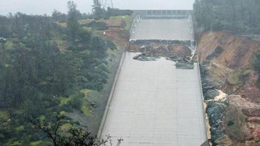
Approximately 90% of the chute foundation required blasting to reach grade. The only extra excavation directed was removal of a few clay seams in the foundation and a few areas where slope failures occurred.

The depth of overburden in the approach channel was deeper than estimated and the slopes had to be changed from 1/2 to 1' to 1 1/2 to 1' to prevent sloughing as the excavation reached the final grade.

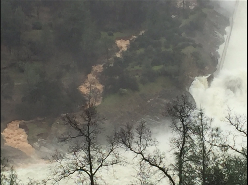
The slopes in the flood control outlet gate section proved to be of a lower quality rock than anticipated. There were several large seams running parallel with the chute. The planned anchor bars were replaced with grouted rock bolts, pigtail anchors, and chainlink surface covering in that area.
Content from External Source
 
Last edited by a moderator:
As of this morning (02-17-17) outflows have been reduced to 80,000 cfs, inflows averaging about 27,400 cfs and the lake level at 861.18 feet (901 is the emergency spillway action) and falling at about three an a half inches an hour. Still no current pictures I see. I kind of figured as much. The state doesn't like to share potentially embarrassing information irrespective of how relevant it may be. Probably an executive order to stop it with the pictures and a trip to visit Bradley Manning for any violators (sarcasm people, just barely but sarcasm).
 
As of this morning (02-17-17) outflows have been reduced to 80,000 cfs, inflows averaging about 27,400 cfs and the lake level at 861.18 feet (901 is the emergency spillway action) and falling at about three an a half inches an hour. Still no current pictures I see. I kind of figured as much. The state doesn't like to share potentially embarrassing information irrespective of how relevant it may be. Probably an executive order to stop it with the pictures and a trip to visit Bradley Manning for any violators (sarcasm people, just barely but sarcasm).
I've got mixed feelings about the lack of recent photos in the areas that concern me most (extent of spill way erosion and newly formed ravine on left hand side). The authorities are clearly working their butts off to keep the reservoir fully contained, and from I can tell they are doing a great job. Will they be successful in the long term remains to be seen, but I hope so. The last thing I would want to have on their priority list is to snap some photos for armchair experts such as myself. That being said, it is likely that this blog is monitored by the authorities, and they are likely to benefit from the insights offered herein, and the more info they provide us the better those insights will be.
 
Last edited:
Stream now running down the side of the broken main spillway


Source: https://twitter.com/JodiHernandezTV/status/832674181787430913

Thanks for posting this. The ravine is clearly increasing in size and in flow, as is the bypass flow just to the left of the left channel wall. I think it is likely that most of the loose soil and loose rock between these to streams is in jeopardy. Some of this will make its way to the river, and will complicate (add to) the dredging operations. It may even be a safety issue for the dredging crews. Not sure if this will impact the extent of the upstream spill way erosion up at the towers, or whether this will lead to further loss of general stability on the hillside given the ongoing deluge (rain). Apparently still no photos posted of the spill way at the towers, although from the news conference I believe they are saying no further upstream migration of erosion.
 
Thanks for posting this. The ravine is clearly increasing in size and in flow, as is the bypass flow just to the left of the left channel wall. I think it is likely that most of the loose soil and loose rock between these to streams is in jeopardy. Some of this will make its way to the river, and will complicate (add to) the dredging operations. It may even be a safety issue for the dredging crews. Not sure if this will impact the extent of the upstream spill way erosion up at the towers, or whether this will lead to further loss of general stability on the hillside given the ongoing deluge (rain). Apparently still no photos posted of the spill way at the towers, although from the news conference I believe they are saying no further upstream migration of erosion.

It looks to me like the stream starts above the break in the spillway. DWR (Croyle) was asked about this during press conference and said they weren't aware of it.
 
Last edited:
"from the news conference I believe they are saying no further upstream migration of erosion."

I have a hard time believing that. Venturi erosion should have taken at least a few feet to a section of the spillway wall away by now.
 
It looks to me like the stream starts above the break in the spillway. DWR (Croyle) was asked about this during press conference and said they weren't aware of it.
When you say "It looks to me like the stream starts above the break in the spillway" is there a photo that you are referring to?
 
"from the news conference I believe they are saying no further upstream migration of erosion."

I have a hard time believing that. Venturi erosion should have taken at least a few feet to a section of the spillway wall away by now.

What are you basing that on?

I don't see why that would be a given. Consider the most energetic part of a regular release - the flow around and over the detentes (big tooth-like things at the bottom).
20170217-130309-p9mq7.jpg
Source: http://www.chicoer.com/article/NA/20170210/NEWS/170219971#

Yes, a patch was needed after a large release some time in the past. But just one spot.
 
Status
Not open for further replies.
Back
Top