Rogerpenna
New Member
Flat Earth was made by people in the Northern Hemisphere. It´s made to have the Polar Star at the center of their map and such.
But what about the SOUTHERN constellations?
The most famous southern constellation is the Southern Cross. It's located near the South direction.
Now, it turns out it can be night at the same time in Brazil and Australia. So a Brazilian and an Australian can BOTH look to their south at the same moment, same night, and BOTH will see the Southern Cross constellation.
OOPS... there is a problem... if the Southern Cross is south of a Brazilian, it should happen that an Australian would need to look almost NORTH to see it! Or vice versa.
Do Flat Earthers think there are TWO Southern Cross constellations? Maybe 3, considering a South African can do the same (although not at the same moment as the Australian and Brazilian... it´s never night in the 3 places at the same time).
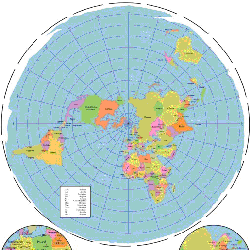
Using the same map above, I want to tell that my sister constantly travels to Hong Kong, from Porto Alegre, Brazil.
It´s full of connections. A Flat Earther would already point out that a scale in Dubai proves a Flat Earth.
Well, maybe it could prove IN the case of Australia to Johanesburg, going through Dubai.
But her flight goes from São Paulo to Johanesburg. Then from Johanesburg to Dubai. Then from Dubai to Hong Kong.
Now, the funny part is that the travel time between São Paulo and Johanesburg is 9 hours 45 minutes.
Johanesburg to Dubai: 8 hours 10 minutes
About 1:30 minutes longer flight.
Eh... let's look at the Flat Earth map again, shall we? The distance from São Paulo to Johanesburg in their map is at least 2x longer than Johanesburg to Dubai. Most likely 3x the distance!*
So it should take from 16 to 24 hours to get from São Paulo to Johanesburg, not 9 hours!
*draw the map to scale in a 3D program and calculated. SP to Joha is actually 4x the distance from Joha to Dubai. Travel time should be about 32 hours!
Another big problem with their model:
7 am in Wellington, New Zealand. 4pm in Brasilia.
Impossible in their map with their sun model.
But what about the SOUTHERN constellations?
The most famous southern constellation is the Southern Cross. It's located near the South direction.
Now, it turns out it can be night at the same time in Brazil and Australia. So a Brazilian and an Australian can BOTH look to their south at the same moment, same night, and BOTH will see the Southern Cross constellation.
OOPS... there is a problem... if the Southern Cross is south of a Brazilian, it should happen that an Australian would need to look almost NORTH to see it! Or vice versa.
Do Flat Earthers think there are TWO Southern Cross constellations? Maybe 3, considering a South African can do the same (although not at the same moment as the Australian and Brazilian... it´s never night in the 3 places at the same time).
Using the same map above, I want to tell that my sister constantly travels to Hong Kong, from Porto Alegre, Brazil.
It´s full of connections. A Flat Earther would already point out that a scale in Dubai proves a Flat Earth.
Well, maybe it could prove IN the case of Australia to Johanesburg, going through Dubai.
But her flight goes from São Paulo to Johanesburg. Then from Johanesburg to Dubai. Then from Dubai to Hong Kong.
Now, the funny part is that the travel time between São Paulo and Johanesburg is 9 hours 45 minutes.
Johanesburg to Dubai: 8 hours 10 minutes
About 1:30 minutes longer flight.
Eh... let's look at the Flat Earth map again, shall we? The distance from São Paulo to Johanesburg in their map is at least 2x longer than Johanesburg to Dubai. Most likely 3x the distance!*
So it should take from 16 to 24 hours to get from São Paulo to Johanesburg, not 9 hours!
*draw the map to scale in a 3D program and calculated. SP to Joha is actually 4x the distance from Joha to Dubai. Travel time should be about 32 hours!
Another big problem with their model:
7 am in Wellington, New Zealand. 4pm in Brasilia.
Impossible in their map with their sun model.
Last edited: