The skies from above and below

Trailspotter

Senior Member.
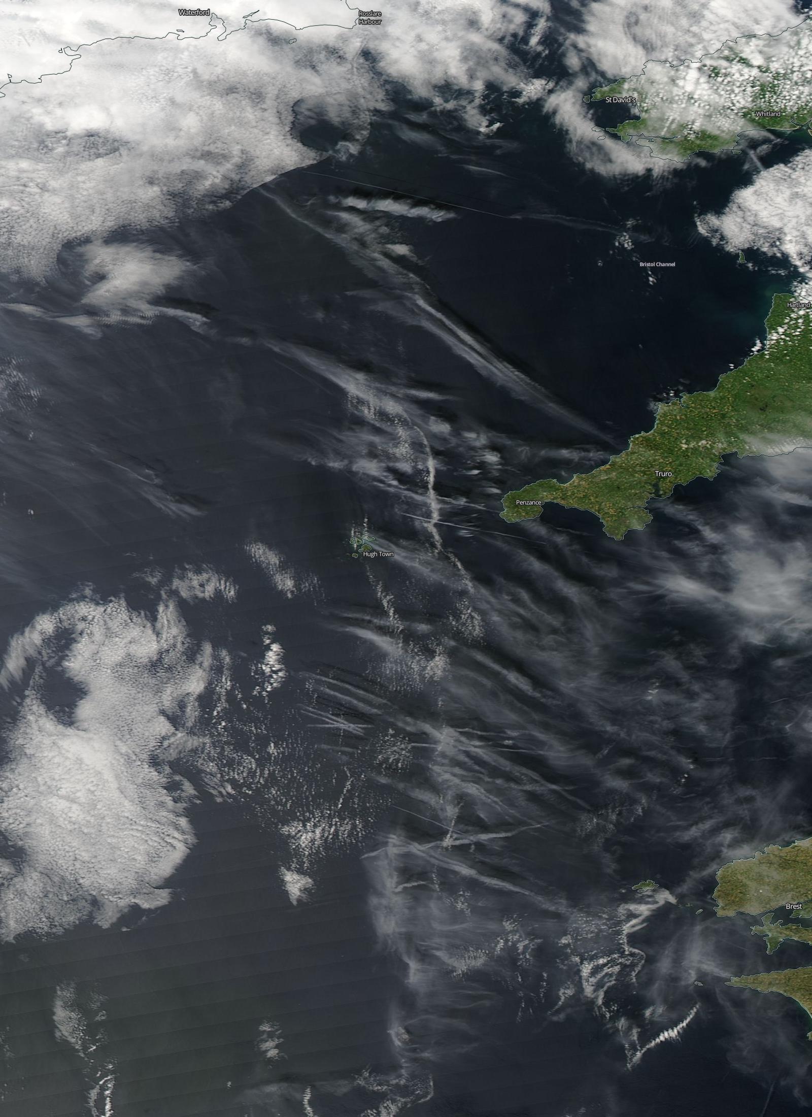
This thread is for the collections of images of clouds, contrails, etc., which are taken synchronously by both satellite and ground-based cameras. For example, the following images of skies to the East of Cornwall are from June 25, 2015 at 14:20 BST (13:20 UTC):
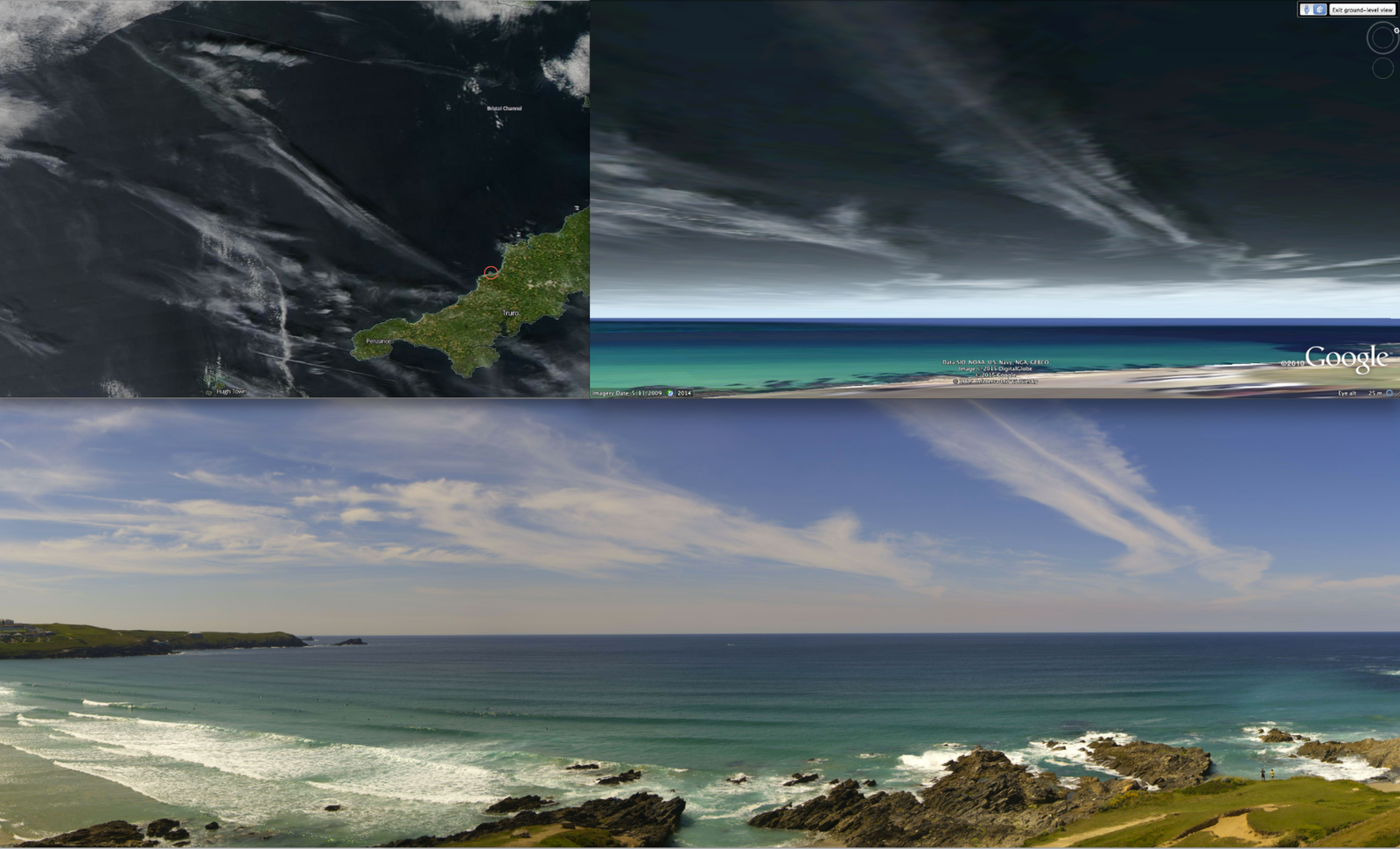
Cornwall20150625A&B_a.png

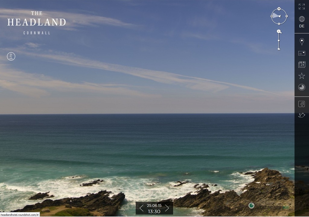
In the upper left corner is the Aqua satellite image and at the bottom is a cropped image from a high-resolution panoramic photo from the archive of a Roundshot webcam. In the upper right corner is a Google Earth ground-level view from the webcam location (red circle) of the satellite image raised to an altitude of ~33,000 ft (10 km). There is a nearly perfect match between the high-altitude cloud shapes in the satellite and ground-level images.

Probably the best way to browse the MODIS satellite images is via the NASA Worldview interface, that has already been discussed here: https://www.metabunk.org/nasa-worldview-new-interface.t5328/
Unfortunately, this interface does not provide the times of the satellite passes, but these can be found on the SSEC site, where the Terra and Aqua orbit tracks are archived as gifs:
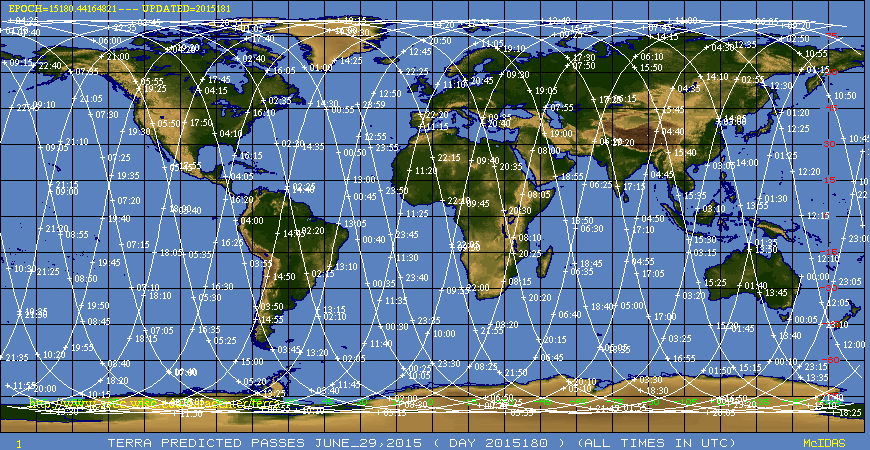
16b6ba2302973a935d7b07b0be1ec1d7.gif

Apart of the Global maps, there are regional maps:
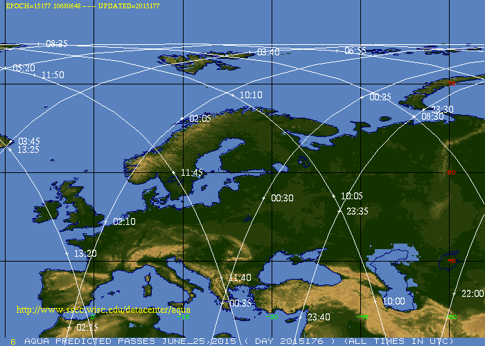
f7d2e0d5f1ae97c1d2247d8af7b6d916.gif

This map of the Aqua orbit tracks over Europe on June 25, 2014 shows that the satellite passed over near Cornwall at about 13:21 UTC.
SSEC also provides the predicted orbit tracks for the next three days. These can be useful for synchronising your own photos and videos of the skies (including time lapses) with the satellite images of the day.

There is even more useful satellite tracking site, http://www.n2yo.com/, that provides 10-day predictions of satellite passes, in particular,
for Terra: http://www.n2yo.com/passes/?s=25994
and Aqua: http://www.n2yo.com/passes/?s=27424

These predictions include the times of satellites' maximal altitudes and their azimuths and elevations. These would give the exact time when the satellite image of the observer's locations is taken. Note that "all passes" option has to be manually selected instead of the default "visible (or night) passes" option.
The predicted passes can also be displayed on the map, showing position of the track relative the observer's location. The registered users (registration is free) can select multiple different locations and toggle between them. This can be useful for taking photos remotely, e.g., by using web cameras in different locations.

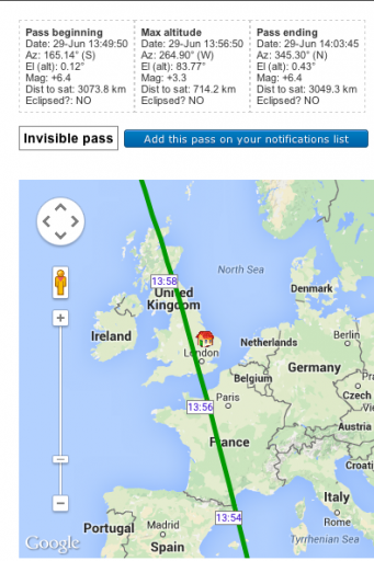
Below are the yesterday's (June 29) predictions for my location in the UK (these have already passed and are not available from n2yo.com anymore):
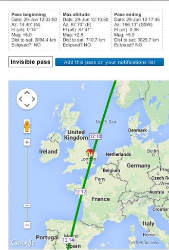
Screen shot 2015-06-29 at 11.40.05.png Screen shot 2015-06-29 at 11.41.30.png

Both Terra and Aqua passed on the day over the same location south of London with the interval of 1h:46m. This is the average value of the time interval between the two satellites' passes for this latitude (~50° N). The average increases to about three hours at the Equator and to more than four hours for the Southern Hemisphere locations, like Australia and New Zealand. However, the time interval varies with the date, depending on the observer's position relative the nearest Terra and Aqua tracks, and can be shorter or longer than the average by up to 80-90 minutes.

I've been taking synchronous pictures of the skies for a few weeks, but am still waiting for an interesting cloud or contrail formation over my location at a right time. Meanwhile, I developed an alternative approach of looking for interesting formations in daily satellite images and checking for the availability of their ground-level images taken at about the same times. I'll present some of my findings in follow-up posts.

In particular, I am looking for suitable web cameras in the areas of interest, which provide image archives and/or time-lapse movies for at least the last 24 hours. The best and most useful webcams I have found so far are from http://www.roundshot.com/. They provide high-resolution panoramic images, which are taken with reasonably short (from 10 minutes) intervals, and their archives in many cases go back for several months and even years.
20150625_142000.jpg

The full 180° panorama of the skies off the Cornish coast from the above example (note that the image size was greatly reduced upon its downloading to Metabunk:().

The most of Roundshot livecam sites also allow to create custom time-lapse movies, which can be used to show how the skies changed during a given day or a longer period. The list of their available cameras has been recently updated to include many new locations around the world:
http://www.roundshot.com/xml_1/internet/en/application/d170/f172.cfm

There are many other webcams all around the world, which can be used to watch the skies remotely in different locations. Creating and expanding a list of such "skycams" could be one of the objectives of this thread.
 
Last edited:
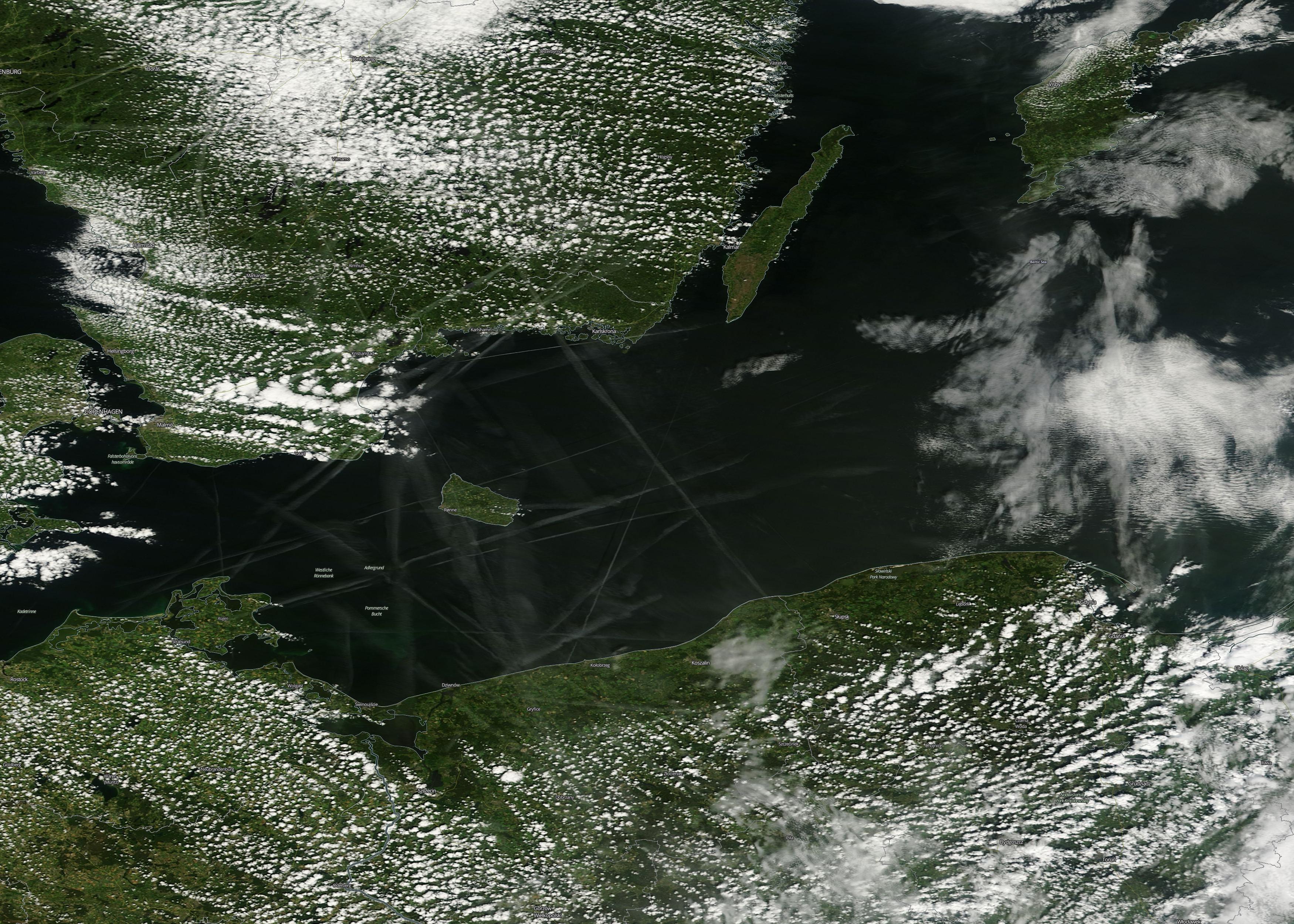
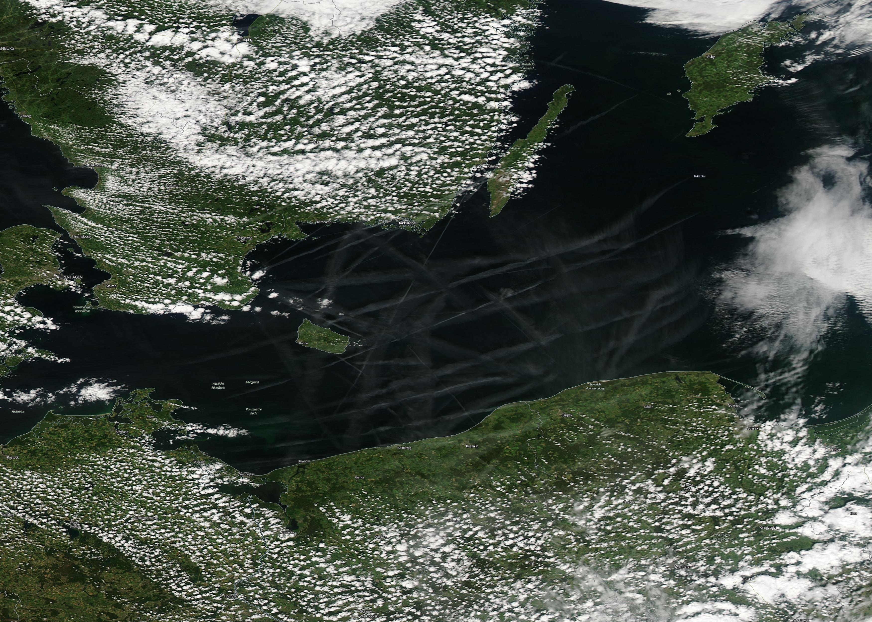
Contrail grid over Baltic Sea, June 30, 2015

There have been clear blue skies above the South of England all day today, so again I've been looking for contrail formations elsewhere and found one above Baltic Sea between Poland and Sweden. Here is the Terra image taken at about 10:15 UTC (12:15 CEST):
ee18e874c4729f2f1756eb0c82dfb1f9._.jpg

and the Aqua image taken at about 12:02 UTC (14:02 CEST):
5b0bd5b259345eec9bf3a958b9db3d44._.jpg


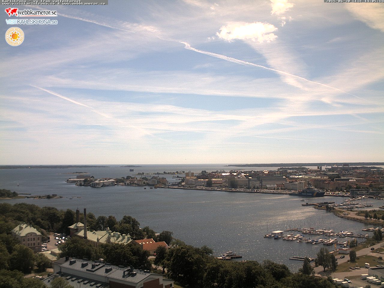
Earlier I found a good collection of Swedish webcams at http://www.webbkameror.se/webbkameror/index.php
Using their map, I selected a nearby camera in Karlskrona. There is a 24-hour archive of images taken every hour. The 14:05 CEST image corresponds well to the Aqua image displayed on Google Earth:
b52d6b0618b7d20be18b0340d53fe87d.jpg

Karlskrona20150630_1400.jpg


I've made an animated gif from the hourly images between 2 AM an 11 PM CEST:
Karlskrona_20150630_.gif

This improvised time-lapse movie shows that the Baltic weather failed miserably to follow the "chemtrail narrative": despite an abundance on persistent spreading contrails during the day, there was a clear sky at the end of it with marine cloud layer forming after sunset.
 
Last edited:
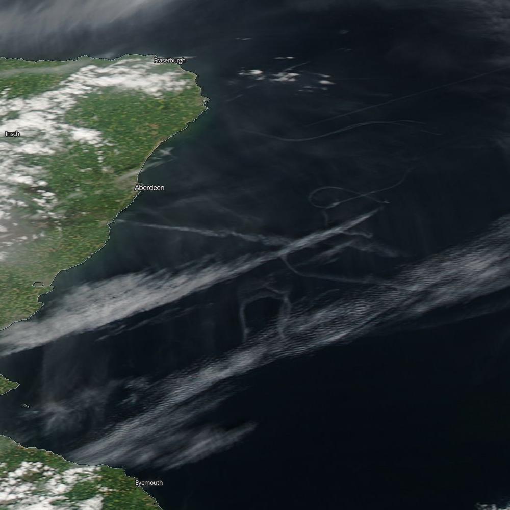
Aberdeen military contrails on June 9, 2015.
http://www.eveningexpress.co.uk/fp/...-cause-of-mysterious-contrails-over-aberdeen/
For the second time in the year, the RAF exercises off the Scottish coast near Aberdeen left "mysterious" contrails. (The first time it was on February 12). The image of contrails from the more recent exercise was captured by the Aqua satellite at about 13:22 UTC (14:22 BST):
0e2a7e5c9043433742ad33b4024a0330._.jpg


I found two ground-level photos taken at about the same time, one on flickr (the camera time is 13:16:34 (GMT?)):

the other on twitter (the posting time 14:23 BST):

They captured different trails in the satellite image and complement each other, as demonstrated by adding the satellite image to Google Earth:
Aberdeen contrails.jpg

(the horizontal white lines are not contrails but linear clouds. They probably were at a lower altitude and, if placed there on Google Earth, they would match the linear clouds below the contrail loops in the flickr photo.

Note, that there are many more photographs of the June 9 contrails taken much later in the afternoon.
 
Last edited:
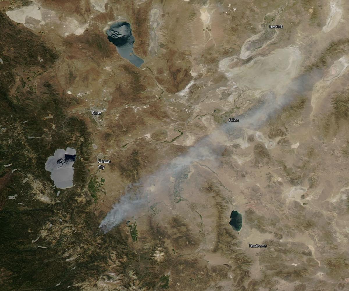
A plume of smoke near lake Tahoe, June 22, 2014

c45673f5f9f809d3075cb48011ccac0f._.jpg

This is not a cloud or contrail, but a plume of smoke from a wild fire southeast of lake Tahoe. It can be seen on the satellite images from June 21 to June 25. In this Aqua image taken on June 22 at about 21:00 UTC (13:00 PDT) the plume is probably the longest, stretching in the northeast direction for about 100 miles.

The plume could have been seen across the lake and was captured by a Roundshot webcam on its opposite side:
Screen Shot 2015-07-01 at 22.01.49.png


Apart of the plume, there was a clear blue sky all day along, as can be seen from the attached
time lapse movie of the day made from the images taken by this webcam.
 

Attachments

Last edited:
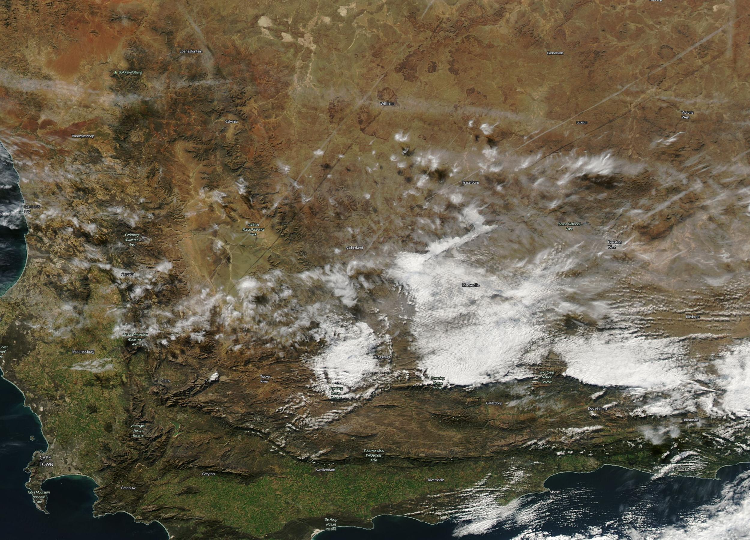
South African Contrails, July 6, 2015

It is Midwinter in Southern Hemisphere. Over the last few days, the MODIS satellites captured images of multiple contrails in South Africa, halfway between Cape Town and Johannesburg. Today the contrail conditions extended further South, to the South African Astronomical Observatory near Sutherland, Northern Cape. In this location, there are a few good web cameras pointing in different directions: http://www.saao.ac.za/sutherland-live/ .
There are also the last 3h videos for each camera, which allow to check for contrails at the times of satellite passes before the satellite images of the area appear on the NASA WorldView. Here is one of the web cam images taken just before the Aqua pass at 12:40 UTC (14:40 local time):
Screen Shot 2015-07-06 at 14.57.20.png

The dome in the foreground is the South African Large Telescope (SALT). The camera points west of north with the black dot being the overexposed Sun image. The two long young contrails correspond to the long diagonal contrails, casting shadows on the ground in the Aqua satellite image:
218de081b63817faca7ea5d95d4104ba._.jpg

Below are the positions of these contrails modelled in Google Earth as seen from the web camera location:
SA_contrails.jpg


There have been more contrails later in the afternoon, as the attached movie shows.
 

Attachments

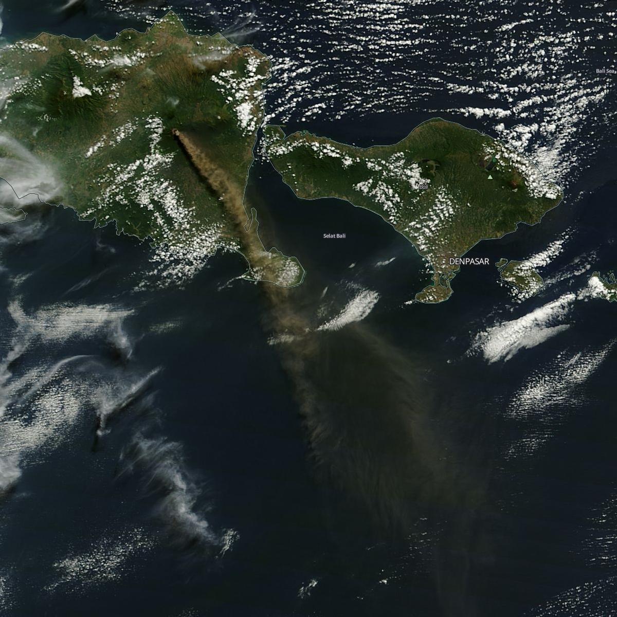
A plume of ash from Mt Raung's eruption, July 12, 2015

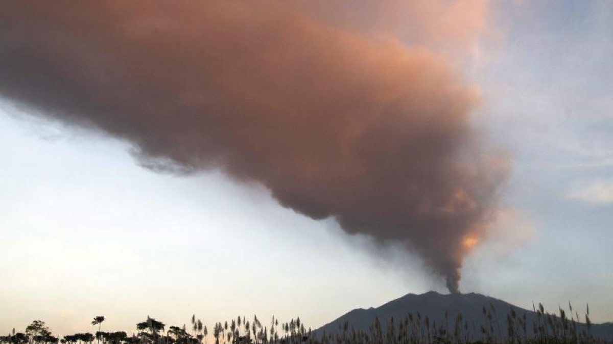
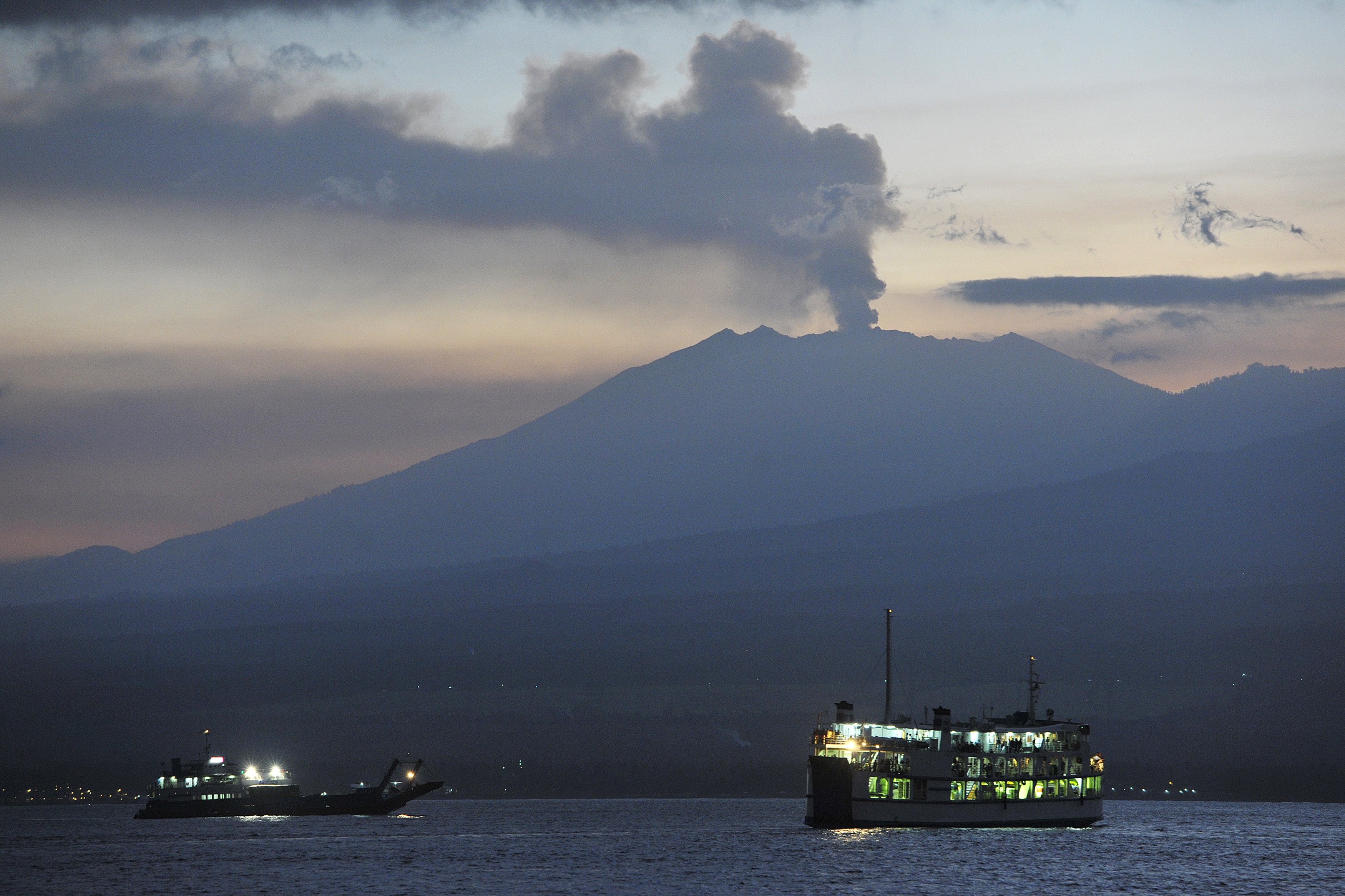
The eruption of Mt Raung volcano in East Java, Indonesia that began on July 2 caused the closure of several airports nearby a week later. As many Australian and other foreign holidaymakers had been stranded on the neighbouring island Bali, this made an international news. The plume of volcanic ash and its spreading over the area can be seen on the NASA Worldview. In the Terra satellite image taken on July 12, the plume's length exceeds 100 miles:
8a45132bcb0cc601be2c9039e8f9d491._.jpg

Here are ground level images probably taken on the same day from the locations east of the volcano, one in Java:
70926157a84a383ab7be7b9e81bc89bf.jpg

and the other in Bali:
a4fe819c4fc4ac54b57b1dc51f1991e7.jpg


I've made an animated gif from the daily satellite images, showing changes of the plume's size and direction between 1st and 14th July 2014:
Raung_July15.gif
 
Last edited:
Natural linear cirrus clouds over Lake Superior, July 25, 2015

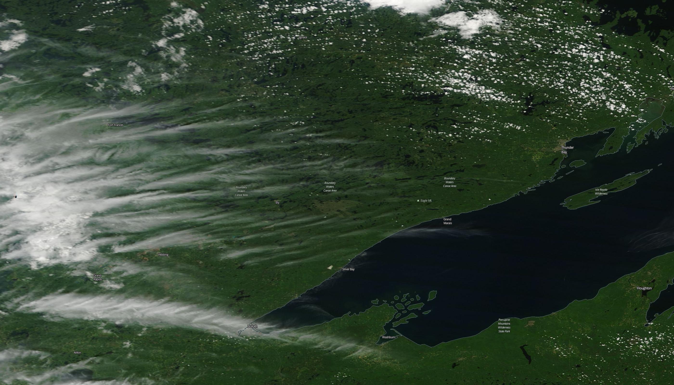
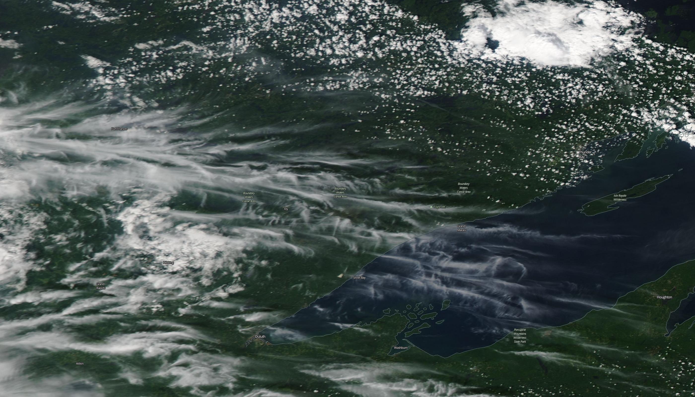
Here are the yesterday's Worldview images of the border area between Minnesota, USA and Ontario, Canada, showing the bundles of natural cirrus clouds coming from the West across the lake Superior.
Terra image, 16:45 UTC (11:45 CDT):
9960aa60403ccf25f15209c79b6fc789._.jpg

Aqua image, 18:30 UTC (13:30 CDT):
7c921eb87673bb8ef197eed925331398._.jpg


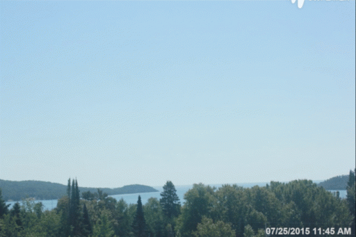
A webcam in the border town Grand Portage, MN has an archive of time-lapse videos, that allows to look at this cloud formation from the ground. Unfortunately, as the camera points south of East, only one linear clouds got into the frame by the time of the Aqua image:
Screen Shot 2015-07-26 at 17.04.02.png

Screen Shot 2015-07-26 at 17.11.19.png

However, more clouds arrived later:
output_EXDX7i.gif
 
Last edited:
There are many other webcams all around the world, which can be used to watch the skies remotely in different locations. Creating and expanding a list of such "skycams" could be one of the objectives of this thread.

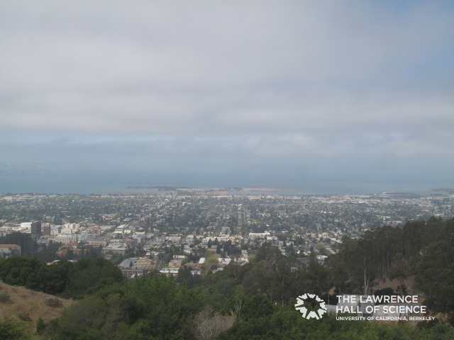
Here is one at the Lawrence Hall of Science in Berkeley, CA at about 1,000 ft elevation, looking west to the Golden Gate Bridge, which you can see if it's not foggy. They also have a time lapse of the previous day, and archives of more interesting days, like lunar eclipses and thunder storms.

http://www.lawrencehallofscience.org/static/scienceview/scienceview.berkeley.edu/html/view/index.php
87d595d52b2e894bcdd413cbb1b6272a.jpg
 
New Zealand contrails, August 2, 2015

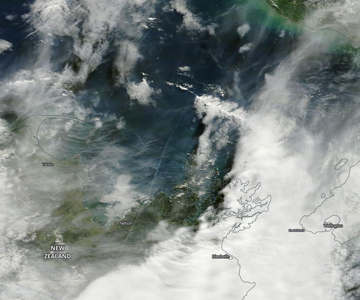
Although contrails should not be a rarity in the New Zealand's skies due to sufficiently lengthy routes of the local air traffic, they were lacking in recent MODIS satellite images (I have been checking them regularly for a couple of months). That is, until today, when I spotted a long contrail in the Terra image taken at about 11:00 NZST (23:00 UTC August 1, 2015):
35bf15fd59597c538b679a20728465c2._.jpg

It aligns well with the Auckland-Christchurch route halfway between the two cities and probably has come from ANZ515.
I've checked the New Zealand webcams in this location. Although I could not find one pointing in the right direction to capture this contrails synchronously with the satellite, several of them have time-lapse movies of the day confirming contrails in the area during daytime. For example, here is a photo from Abel Tasman Anchorage Webcam:
Screen Shot 2015-08-02 at 10.43.28.png

The time in the upper left corner is my local time, UTC+1, that is 11:17 NZST. This and other NZ webcams use the snapitHD2 system that allows users to view an entire day as a fullscreen time-lapse by moving the mouse from left to right.
I've made an animated gif from full HD screenshots, but I cannot upload it to Metabunk because of the size, so I've made a smaller version:
output_z3PVaM.gif
 
Saharan dust coming out of Africa, August 3-7, 2015

The Sahara desert's dust is carried by wind over large distances. It fertilises the Amazon rainforest in South America and causes "blood rain" in Europe. This week, a new dust cloud whipped by the storm in the South of Algeria on August 3 by now has reached Canary Islands and Iberia Peninsula, as can be seen in the loop below made of MODIS satellite images from August 3 to 7:
Sahara_3-7Aug15.gif

and brought hazy skies to all these places, as seen, for example, in these flickr photos taken on August 6, 2016 in Lanzarote

and Andalusia
 
Typhoon Soudelor Makes Landfall in Taiwan, August 8, 2015

I have been watching the development of this tropical storm in Pacific from the end of July, while it has headed straight toward the Chinese coast, gathering strength on the way. Here is a loop of MODIS satellite images from July 26 to August 8:
Typhoon_Soudelor.gif

Its name, however, I've learned only today after the typhoon has made international news by hitting Taiwan. The following video shows its impact from the ground:
 
Last edited:
Nagasaki contrails, August 9, 2015

While watching the BBC News this morning, I've spotted a few contrails in the reportage on commemoration of the 70th Anniversary of Nagasaki bombing:
Screen Shot 2015-08-09 at 10.00.00.png

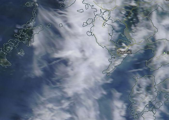
This short was taken at the Nagasaki Peace Park in westerly direction. Checking the MODIS satellite images confirmed that there were contrails near Nagasaki today. Here is the Terra image taken at 2:55 UTC (11:55 local time):
b648b280183a5e033547a3bb7de6058d._.jpg

The position and orientation of a longer contrail to the West of the city match well to those of the contrail in the upper left corner of the BBC picture above.
 
Sandstorm in Syria, September 7, 2015

1e17793d9ef08f82bf354d376ae3fbfe.jpg


External Quote:
The sandstorms protect the Syrians from al- Assad's air force
The provinces of Homs, Idlib, Lattakia, Hama, Deir Ezzpr and other areas in Syria have witnessed sandstorms in most of their cities and villages, these sandstorms have protected the Syrian citizens from the barrel bomb dropped by al- Assad's helicopters and from the missiles launched by the regime warplanes that kill the Syrians every day.
Here is how this sandstorm looked from the space in the Aqua satellite image of the area:
a0aa064c359a4984227dddef6e98399a._.jpg


EDIT: More image from Israel affected by the same sandstorm:
f348bf660b84338ab2d1256331f276cc.jpg

http://www.timesofisrael.com/israel-shrouded-in-dense-sandstorm/
698381789c0a7d8bca78f138fcce467b.jpg

External Quote:
A severe dust storm arrived Monday in Israel, covering parts of the country in a heavy haze that could pose a health risk to some, the environmental protection ministry said.
The muggy weather was said to be the result of a sandstorm originating in Syria and Iraq now passing over Israel, and is expected to continue throughout the day, even extending into Wednesday, accented by a possible heat wave, the Meteo-Tech meteorological service said.
read more: http://www.haaretz.com/news/israel/1.675047
 
Last edited:
I was naturally intrigued by the possible origination of the corridor of contrails.

150625-1520CEST-Newquai.jpg


I knew:
Date 1915-06-25
Height 32000~35000FT
Time of perception 13:20UTC.

Unknown:
Wind direction @32000~35000FT

So I looked up for 2 scenarios. The northernwind scenario appears to me the most plausible one.

Here the northernwind scenario (might be not very accurately done, be it assumptive):

150625-1419CEST-Newquai_PFc.png
After a longer pause, a bunch of aircrafts flew over Wales, Started with KLM17. 12:19UTC
I set a filter for alt. 32000~35000FT.

Then:
150625-1450CEST-Newquai_PFc.png

After 12:50UTC supplemented with VirginAtlantic and/or AirTransat
@ 13:20UTC the corridor would be in place.

150625-1520CEST-Newquai_PFc.png


The southernwindscenario -- to me less plausible; less aircrafts involved and resulting direction of the corridor less matching.

150625-1455CEST-Newquai_PFzc.png


And a winddirection parallel to the corridor scenario? Found one matching aircraft.


Jan.
 
The southernwindscenario -- to me less plausible; less aircrafts involved and resulting direction of the corridor less matching.

View attachment 19868


And a winddirection parallel to the corridor scenario? Found one matching aircraft.


Jan.

Actually, this is the most likely scenario. According to earth.nullschool.net, the wind direction at 250 kPa at the time was SWW:
Screen Shot 2016-07-11 at 16.01.35.png

At 500 kPa the wind was even more southerly :cool:

Also, a crosswind of such a speed (60 km/h) would deflect contrail by about 5° compared to the plane heading.

Update:

I've checked the webcam archive at the OP link: http://headlandhotel.roundshot.com and found that:

1. The contrails indeed moved from left to right, that is, in northerly directions, as 'predicted' by earth.nullschool.net;

2. The contrails in question were formed more than one hour earlier than the satellite image timestamp, between 13:00 and 13:10 BST (12:00 - 12:10 UTC)

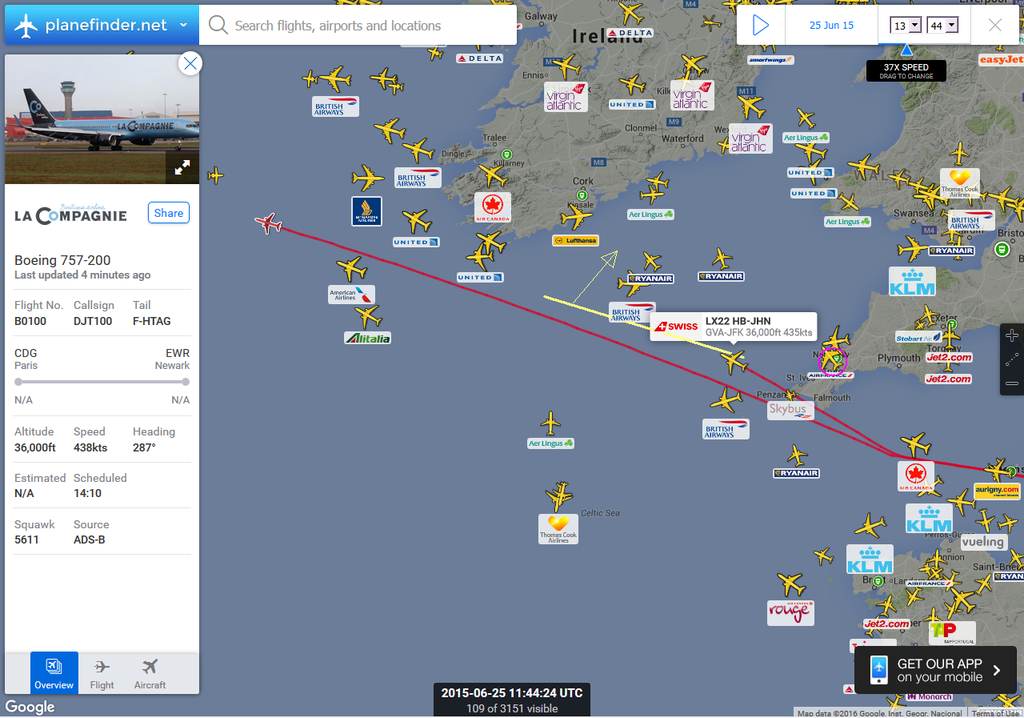
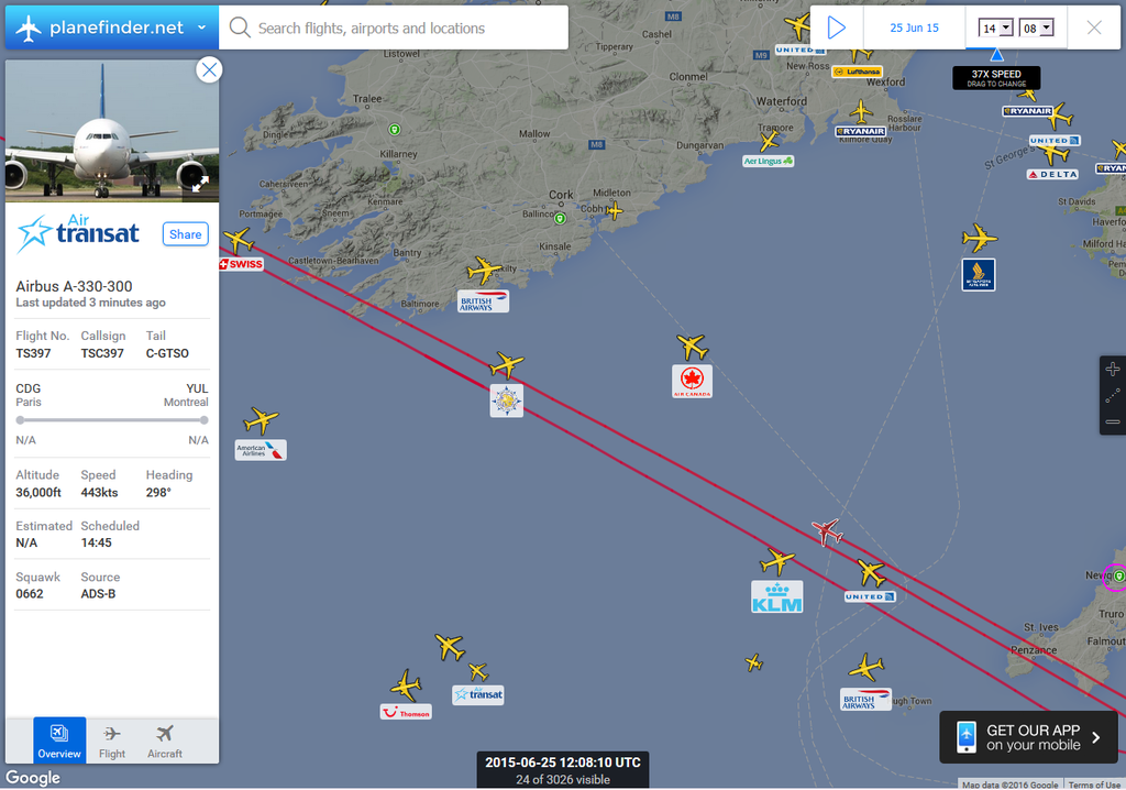
This suggest a different set of candidate flights, most likely, these two A330s (LX22 and TS397), which were flying at the same altitude of 36,000 ft along almost the same track. This track is roughly parallel to the contrails in the satellite image and is at about right distance from their location to be moved there in one hour by the 'predicted' wind:
Screen Shot 2016-07-11 at 17.21.56.png
 
Last edited:
Thnx :)

Though the contrail-bundle seen from the satellite is heading more diagonal the the Swissair and the AirTransat, even more with 5 degrees deviatation -- even more horizontal -- taken into account.

Maybe, due to a stronger wind above the sea then closer to the coastside, the bundle had changed direction.

Are you sure, persistent ctrls formed @ 36000FT here?


Jan.
 
Maybe, due to a stronger wind above the sea then closer to the coastside, the bundle had changed direction.
Yes, according to earth.nullschool.net, the wind along the Irish coast at 250 hPa (70 km/h) was stronger than along the Cornish coast (60 km/h). Thus the contrail bundle was not only moved, but also rotated by the wind.
Below is a crop of the panoramic photo timestamped as 13:10 BST that shows the contrail bundle near the time of its origin:
Screen Shot 2016-07-16 at 10.06.15.png

The panoramic photos were taken at 10 minute intervals. The longest and thickest contrail 1 was formed before 12:50; contrail 2 first appeared at 13:00, whereas the youngest contrails 3 and 4 at this (13:10) photo. The position and orientation of this bundle are in a good agreement with the route proposed in my previous post and illustrated with Swissair LX22 track. I have overlaid that image on Google Earth, raised it to 36,000 ft and looked at it from the same location on the ground in the same direction (due East), as in the cropped photo:
Screen Shot 2016-07-16 at 11.06.13.png


Are you sure, persistent ctrls formed @ 36000FT here?
There was 100% humidity at 250 hPa in this and surrounding areas. The same satellite swath shows more contrails south to the bundle:
75f349e941ec8e8d5abd45457c571089._.jpg
 
I tried to figure it out, but got puzzled.
Ctrl #3 seems to be TSC397 (AirTransat), Originating around @ 12:10 UTC.
But the ctrl from SWR22B (which I thought it were ctrl #2) should be more north of the TSC397-one, regarding the wind direction. It is not the case.


Also, the TSC397-ctrl is far more stretched towards the northwest then the thicker trail. This mght indicate that the other ctrls are at another height (see below).


Jan.
 
I tried to figure it out, but got puzzled.
Ctrl #3 seems to be TSC397 (AirTransat), Originating around @ 12:10 UTC.
But the ctrl from SWR22B (which I thought it were ctrl #2) should be more north of the TSC397-one, regarding the wind direction. It is not the case.
My previous post was in support of the proposed initial location of the contrail bundle. You went to the next iteration - the assignment of individual trails to the known flights. This can be an interesting exercise, but finding the correct solution from a number of possible combinations is not straightforward and may take more time than I'm willing to spend on it. A proper way of doing this would be to download all relevant flight tracks from Flightaware in KML format and to look at them on Google Earth from the known camera location. Unfortunately, these data are more than one year old and not available for free anymore.

Anyway, my best guess is that contrail #1 belongs to either UA169, or UA975, or both (merged together by 12:50); #2 is LX22; #3 is AC887 and #4 is TS397. Two of these were at 36,000 ft, the others at 34,000 ft.

I will take a look for that.

Also thnx for the hints using G-Earth :)


Jan.
 
Back
Top