Skinwalker Ranch S4 E11 Claims of "Wormhole" from LIDAR Scan with Gap

LeastWeasel

New Member
IMG_1830.jpegIMG_1831.jpegIMG_1830.jpegIMG_1831.jpeg
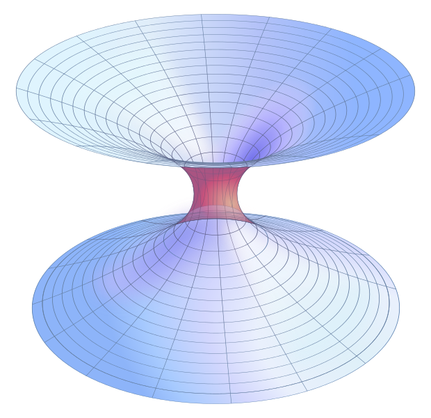
This Episode they brought in a well equipped Defense Contractor with gadgets galore. The high speed camera guy returned. They went full Rambo on the mysterious anomalous phenomenon. They assaulted the invisible anomaly with the normal barrage of rockets, flamethrowers, and a Tesla Coil. They had the normal very predictable equipment failures. The above (photographed TV) images were presented in the final segment. It is from a drone with LiDAR as they launched a rocket at the “anomaly “ while the LiDAR drone scanned from above. The red circle and black hole were the result of the scan. The second picture is the explanation by Travis Taylor. He described this as a wormhole.
I’m just a formal field scientist for the Coast Guard, so my understanding of the tech and wormholes is limited. But even with my limitations, I can’t imagine how the wormhole conclusion was reached. Of all the strange conclusions this series has made, this has to be crazier than the 36,000 MPH bug. The discovery of a wormhole would be a stop the presses event.


Last edited by a moderator:
"Could that really be what causes all the energy spikes, the blobs, and the UAPs...".
No, Travis. No, it could not. On the other hand we are still waiting for evidence of energy spikes, blobs, or UAPs. :)
 
How does this website even handle Skinwalker related questions going forward, now that there's been numerous occasions of them manipulating, data, or possibly faking data? For example, the downgrade in quality of video from the trailer to the show's release that Mick pointed out at this post. Is it worth continuing to debunk an untrustworthy source?
 
I don't think this is even the first time Taylor has mentioned a "wormhole" at SWR. Steven Greenstreet's take down video had Taylor flipping a wipe board over with a bunch of calcs and drawings of a wormhole from a previous season.

How does this website even handle Skinwalker related questions going forward, now that there's been numerous occasions of them manipulating, data, or possibly faking data? For example, the downgrade in quality of video from the trailer to the show's release that Mick pointed out at this post. Is it worth continuing to debunk an untrustworthy source?

I guess it would depend on the Metabunk member. If they're going to continue to call flies UFOs, it's worth pointing out that it's a fly. Their main audience doesn't care, they want UFO and wormholes, but IF just one or two of them end up here to see how foolish the skeptics are and is confronted with repeated debunks, maybe they'll change their mind.

And if they have to increasingly resort to data manipulation and/or faking stuff so as not to be debunked, that says a lot about them.
 
They haven't discovered a wormhole (as in an Einstein-Rosen bridge or any similar cosmological structure).
No-one's ever discovered a wormhole, or evidence of wormholes.

I'd be very surprised if anyone involved truly believes that they've found a wormhole.

A wormhole connecting a point on the ground in Skinwalker Ranch territory and a point in the air not that far above it (as the graphic suggests) would be of limited utility (though of enormous scientific interest), but due to the energies required in physicist's models of wormholes- and those models are the only reasons we have to believe that wormholes might, just might be possible- a wormhole intersecting, or ending on, Earth's surface would probably be clearly visible as something dramatic.

Due to the Skinwalker Ranch crew's demonstrated inability to procure or maintain reliable instruments, and their inability to interpret information from their instruments in a competent manner (e.g. the hypersonic giant fly), it must be more likely that they have uncovered an actual wormhole.

earthwormhole.jpg

Annoyingly, the joke's on us, I expect the Skinwalker Ranch gentlemen get paid a lot more than most Metabunkers.
 
Annoyingly, the joke's on us, I expect the Skinwalker Ranch gentlemen get paid a lot more than most Metabunkers.

Indeed. Add in their appearance fees for various conventions and other gigs, even if they made $0.10 for each appearance, it's more than Metabunkers make, at least in this realm.

Nevertheless, I think a constant stream of debunks is useful. If nothing else, it's a thorn in the side of Taylor and the crew. In the grand scheme of things, Metabunk is an obscure online forum and not part of the Discovery networks but, it can still point out the shortcomings of the show for what it's worth. I think they know it.
 
How does this website even handle Skinwalker related questions going forward, now that there's been numerous occasions of them manipulating, data, or possibly faking data? For example, the downgrade in quality of video from the trailer to the show's release that Mick pointed out at this post. Is it worth continuing to debunk an untrustworthy source?
I couldn’t agree more, it is like trying to debunk Finding Bigfoot or Ghost Hunters.
 
IMG_1830.jpeg.jpg
It looks to me that to create this scan, they fixed the drone in place and rotated it. The central black area is a "shadow", i.e. a place that the Lidar didn't reach. And the red data might be spurious data that is circular because the drone rotated. Both changed when they adjusted the angle of the Lidar.

From the first video clip, at the very end, comes the ideal reaction to the SWR claims:
SmartSelect_20230714-063843_Samsung Internet.jpg
 
It looks to me that to create this scan, they fixed the drone in place and rotated it. The central black area is a "shadow", i.e. a place that the Lidar didn't reach. And the red data might be spurious data that is circular because the drone rotated. Both changed when they adjusted the angle of the Lidar.
I agree. This was my first thought as well. The platform for the drone is also located right at the edge of the black circle spot. So it is not unthinkable that they flew up straight and a bit to the side (towards the center of the black spot), and then did the scan by rotating the drone.
It would be interesting to see the data for the flight path of the drone, to verify this.
Skinwalker_dronepad_arrow.jpg

Skinwalker_dronepad_arrow_lidar.jpg
 
They haven't discovered a wormhole (as in an Einstein-Rosen bridge or any similar cosmological structure).
No-one's ever discovered a wormhole, or evidence of wormholes.
Content from External Source
Isnt it an insane amount of energy needed to open up a wormhole and yet even more to stop it collapsing?
As you said its only thought to be theoretically possible due to Einstein, and E = MC2
So wouldn't the mass be incredibly dense then? A huge amount of concentrated energy would also affect the surrounding air would it not (heat it up?)

I mean a wormhole is not something you can just 'miss' is it?
Yes. As @John J., whom you're quoting, continues:
due to the energies required in physicist's models of wormholes- and those models are the only reasons we have to believe that wormholes might, just might be possible- a wormhole intersecting, or ending on, Earth's surface would probably be clearly visible as something dramatic.

Tip: If you want to reply to a part of a post, highlight it with your cursor, wait for the "Reply" popup, and use it.
 
Sheesh....this stuff is baloney on so many different levels.

I mean, look what their large, circular, 'wormhole' caught on LIDAR exactly lines up with.

Oh, no....its an irrigation sprinkler system from the 17th dimension !........


circle.jpg
 
I guess it would depend on the Metabunk member. If they're going to continue to call flies UFOs, it's worth pointing out that it's a fly. Their main audience doesn't care, they want UFO and wormholes, but IF just one or two of them end up here to see how foolish the skeptics are and is confronted with repeated debunks, maybe they'll change their mind.

And if they have to increasingly resort to data manipulation and/or faking stuff so as not to be debunked, that says a lot about them.

Great point. It's still worth to deconvert as many as we* can. (* By we, I mean everyone else here. I don't have the debunking skills most here do :))
 
Sheesh....this stuff is baloney on so many different levels.

I mean, look what their large, circular, 'wormhole' caught on LIDAR exactly lines up with.

Oh, no....its an irrigation sprinkler system from the 17th dimension !........


circle.jpg
I'm not seeing it. Could you (or someone else) identify corresponding terrain festures?

The idea that high reflectance might be caused by water drops felt plausible, but couldn't think of a source for them.
 
Does anybody know what modern physics predicts for the area around a wormhole? Should be there measurable physical phenomena that can be measured without actually getting in the wormhole and ending up across the universe?
 
I'm not seeing it. Could you (or someone else) identify corresponding terrain festures?

I have the wrong area. But...I'd make the point that the entire area is littered with irrigation circles. There is a large one just .75 miles to the east of the Skinwalker Ranch Triangle, and a smaller one ( much the same size as the 'wormhole' circle ) about 1.3 miles to the west. It's also worth noting that according to the 2009 Google Earth photo that specific area was flooded and it is evident from historical photos that flooding of that patch is quite common, with no indication that the water actually flows further out of that patch.

So it is not always the dry dusty environment portrayed in the series. There is flooding of the river ( the stream to the north ) , with consequent transport of river materials into the surface. And that would affect any survey.
 
Sheesh....this stuff is baloney on so many different levels.

I mean, look what their large, circular, 'wormhole' caught on LIDAR exactly lines up with.

Oh, no....its an irrigation sprinkler system from the 17th dimension !........


circle.jpg
I don't think the scales match for that circular patch of greenery to be the observed black patch. It should be closer to the buildings in size, rather than the field.

PS: missed your update. Yeah, looking at the roads, I think it is a different area (assuming that up is north in your picture)
 
Last edited:
measurable physical phenomena
I read some basics of wormhole theory (high school level) and it would need negative energies to prevent gravity from collapsing the tunnel. Not sure exactly what all that means, but I do know it’s not what the LiDAR detected that night.
 
Does anybody know what modern physics predicts for the area around a wormhole? Should be there measurable physical phenomena that can be measured without actually getting in the wormhole and ending up across the universe?

Well, giving some of the descriptions of wormholes:

Formalizing this idea leads to definitions such as the following, taken from Matt Visser's Lorentzian Wormholes (1996).[11][page needed]

If a Minkowski spacetime contains a compact region Ω, and if the topology of Ω is of the form Ω ~ R × Σ, where Σ is a three-manifold of the nontrivial topology, whose boundary has topology of the form ∂Σ ~ S2, and if, furthermore, the hypersurfaces Σ are all spacelike, then the region Ω contains a quasipermanent intrauniverse wormhole.
Content from External Source
And the mathematical (Mendel, Fatphill) expressions of worm holes such as (had to screen shot as all the Greek letters don't copy):

1689353852380.png
1689353887449.png
https://en.wikipedia.org/wiki/Wormhole#Metrics

I can confidently say "I have no idea". :confused: Wait, what was the question? My head hurts, I'm going to go work in the shop now, it's something I understand.
 
The area, about 450m East of the ranch, no pond, no irrigation, no change in topography (note; the lidar image is a more oblique view).
There's nothing physical that would account for the anomaly.(The typo is accounted for messing with images late last night).
skinwalker location of lidar anomoly.jpg
This is not a topological map, so excluding topoloy as a solution is wrong. The patch on the right looks like the black blob from the original image.. half circle plus a smaller bell shape. The scale of it is also within the ballpark. Nevermind, the scale is off. It would be way bigger than what was shown.
 
Last edited:
Before I make more of a fool of myself, can anyone detail exactly what the imaging that they were doing represents? Reading about lidar through Wikipedia shows that it can be used in a lot of ways and that is a major premise that should be stated.
 
Okay, 3d topological map with a heatmap for height. Given that heatmaps apply across a span of absolute values, how abnormal would the black patch have to be to get discarded by the software, rather than being the first shade of blue? Is that abnormal enough to exclude topology as the solution?

As for the red ring, can rain explain that? Given that the software might make some statistical analysis to exclude spurious input, wouldn't rain (or similarly dust or smoke) result in spurious output at the threshold? Just throwing ideas out there...
 
Last edited:
Just for reference, here is the Wiki for LIDAR:

Lidar
Content from External Source
(/ˈlaɪdɑːr/, also LIDAR, LiDAR or LADAR, an acronym of "light detection and ranging"[1] or "laser imaging, detection, and ranging"[2]) is a method for determining ranges by targeting an object or a surface with a laser and measuring the time for the reflected light to return to the receiver. LIDAR may operate in a fixed direction (e.g., vertical) or it may scan multiple directions, in which case it is known as LIDAR scanning or 3D laser scanning, a special combination of 3-D scanning and laser scanning.[3] LIDAR has terrestrial, airborne, and mobile applications.[4][5]https://en.wikipedia.org/wiki/Lidar

Lidar is commonly used to make high-resolution maps, with applications in surveying, geodesy, geomatics, archaeology, geography, geology, geomorphology, seismology, forestry, atmospheric physics,[6] laser guidance, airborne laser swathe mapping (ALSM), and laser altimetry. It is used to make digital 3-D representations of areas on the Earth's surface and ocean bottom of the intertidal and near coastal zone by varying the wavelength of light. It has also been increasingly used in control and navigation for autonomous cars[7] and for the helicopter Ingenuity on its record-setting flights over the terrain of Mars.[8]
Content from External Source
And because I don't always trust the SWR crew, yes LIDAR can be mounted to drones:

The DJI Matrice 600 and 600 Pro can be used to carry many different lidar sensors. Many solutions require a lidar sensor and also another sensor such as RGB camera for photogrammetry or a multispectral sensor mounted on the drone to capture the images for the particular solution. So in choosing a drone, the payload capacity of both a lidar sensor and RGB camera needs to be taken into consideration.

Here is the list of the lidar drones being used to carry the most popular lidar sensors detailed below;
  • DJI M600 Pro lidar quadcopter
  • Draganflyer Commander
  • Riegl RiCopter Lidar UAV
  • Harris H4 Hybrid HE UAV
  • VulcanUAV Harrier Industrial
  • VelosUAV helicopter
  • Robota Eclipse fixed wing drone
  • DJI Matrice 200 Series quadcopter
  • OnyxStar Xena drone lidar
  • OnyxStar Fox-C8 HD quadcopter
  • GeoDrone X4L lidar quadcopter
  • Tron F9 VTOL fixed wing lidar
  • Boreal long range fixed wing drone
  • Vapor 55 UAV helicopter
Content from External Source
And in 2021 from a company that promotes photogrammetry over LiDAR due to cost (bold by me):

In some ways, lidar is easier to process simply because it is less detailed than photo-based datasets. However, there is no cloud-based lidar processing on the market at present; you have to do it yourself. That requires in-house software and computing hardware, as well as a specialist who can adequately render and correct all of that raw data.
Content from External Source
https://www.propelleraero.com/blog/drone-surveying-misconceptions-lidar-vs-photogrammetry/
 
I’m trying to be Mr. West and failing drastically!
My log of events
All or some electronics crashed?

Electronics working

Drone launched IMG_1837.png

Real time drone data
IMG_1838.png

Rocket launched

LiDAR data around rocket dispersed, tech says 20 feet, DTT says “so at 30 feet”IMG_1838.png

Second rocket launched with drone at same location

Rocket is not seen on LiDAR IMG_1841.png

Go back to CC to review high resolution data

No data in the blob area IMG_1840.png

I don’t see a wormhole, of course I’m not sure what to look for.
 
Okay, 3d topological map with a heatmap for height. Given that heatmaps apply across a span of absolute values, how abnormal would the black patch have to be to get discarded by the software, rather than being the first shade of blue? Is that abnormal enough to exclude topology as the solution?
The data are displayed on the show in at least two ways, reflectivity and height.
2023-07-14_12-15-23.jpg

2023-07-14_12-13-37.jpg

"Reflectivity" is how much of the light is bounced back to the LIDAR unit. "Height" is the height above the designated zero point, which looks like 1475 meters above sea level.

In both types of images there's the black void, and black shadows - especially noticeable behind the jeeps and the canopies. The black indicates that there's no data - because the area is never visible to the LIDAR.

Normally to get a detailed 3D map of a region your would fly all over it, so you can see bedhing things, and see things from different angles.

The void is the same in both mode, as are the shadows. So this is simply a region that the LIDAR did not look at.

The shape of the void looks like it is composed of arcs, which suggests a combination of rotating the drone and rotating the camera on the gimbal. They just did not look down, as they were not actually trying to make a map - but rather trying to observe the rocket launch on LIDAR.
 
Last edited:
There's a third mode, RGB, which attempts to render the point cloud in the correct colors. Here the void seems bigger. Drag to compare.


Attachments

  • 2023-07-17_15-28-23.jpg
    2023-07-17_15-28-23.jpg
    52.8 KB · Views: 89
Last edited:
If the black hole at the centre is a result of the rotation of the drone, and the field of view of that drone, maybe the brighter red ring is also a function of the equipment?

One possibility that occurs to me is that the high reflectivity in that region is caused by opposition surge - the light that is reflected directly from a rough surface becomes brighter at certain angles because the self-shadowing effect is minimised.
https://en.wikipedia.org/wiki/Opposition_surge
At a phase angle of zero degrees, all shadows disappear and the object is fully illuminated. When phase angles approach zero, there is a sudden increase in apparent brightness, and this sudden increase is referred to as the opposition surge.
 
@Mick West is the RGB image extrapolated from the lidar data or is there a RGB sensor as well, as might be expected from what @NorCal Dave presented (though I am under the impression that everything happened at night, would a RGB sensor even capture anything useful?). From the image comparison (awesome website feature) I am more impressed by the lack of the red ring being expressed in RGB space rather than black blob size.
 
There's a third mode, RGB, which attempts to render the point cloud in the correct colors. Here the void seems bigger. Drag to compare.

[compare]
Brighter triangle RGB.jpg
2023-07-14_13-48-53.jpg
[/compare]
Not only is the blank area a different size, but its deviations from a circular shape are on a different axis, clearly visible when you slide the "compare" bar back and forth, although the visible vehicles etc don't change. I think that is indicative of a change in position of their instruments.
 
If we look at all the shadows from the scan, they all intersect at the center of the black spot, which would happen if the drone is stationary and rotating while scanning. It actually also suggests that it was at a fairly low altitude if you look at the tree on the right which casts a long shadow. I don't know if it would create this highly reflective circle at a low altitude, but it would be interesting to see the results if someone has an identical system and has the opportunity to test it out.

shadows.jpg

They are using the DJI Terra program which suggests that they are using a DJI drone. From what I can tell they are using the DJI Zenmuse L1 LiDAR sensor on a DJI Matrice 300 RTK drone.

Drone.jpg
 
I presume this image is a computer-generated representation of a wormhole located above this 'anomaly'?


It appears to be nothing more than a generic representation of a wormhole superimposed on the LIDAR data. However, this sort of representation of a wormhole is not really representative of what a wormhole would look like in reality - instead, it is a graphic representation of what a wormhole connecting two spacially-separated, three-dimensional regions of space would look like if you eliminated one of the spatial dimensions by reducing those volumes to flat planes.

This is known as an 'embedding diagram' and looks like this.

Taylor seems to have simply added an 'embedding diagram' to the LIDAR image, implying that the other mouth of the wormhole would appear a few hundred feet above the landscape. This is not the case - the other mouth could, in theory, be literally anywhere in time and space.

If it were not purely imaginary, of course.
 

This is known as an 'embedding diagram' and looks like this.

That's the same image used on the Wiki page for wormhole. Here is the basic info for the image:

1689373971422.png

And it's free to use though he does ask for attribution:

1689374038515.png
https://commons.wikimedia.org/wiki/File:Lorentzian_Wormhole.svg

They may have used it, or just made their own to insert.

As you mentioned, a wormhole that only goes maybe a 100' from it's origin might be cool, but not very useful. At least for all the UFOs, dinobeavers and 7' werewolves running around SWR.
 
I apologise; that is the correct attribution. Thanks for giving it.
Silly of me; I've made several similar images of my own, and I could have used one of those.
 
Last edited:
Back
Top