
Photo experiments from the Minch Sea, Scotland.
Took photos and videos whilst traveling from Oban to Barra ferry and vice versa. Height above sea level approximately 50 feet.
Photo's taken over distances up to 80 miles away from observed islands and hills in both the Outer and Inner Hebrides.
Distances calculated from Google Earth.
Interestingly enough, Isle of Barra (facing due West) does indeed recede (as curvature equations would predict) into the sea. Island gradually disappears until major hill peaks can only be seen. Furthest photo is at a distance of 42 miles.
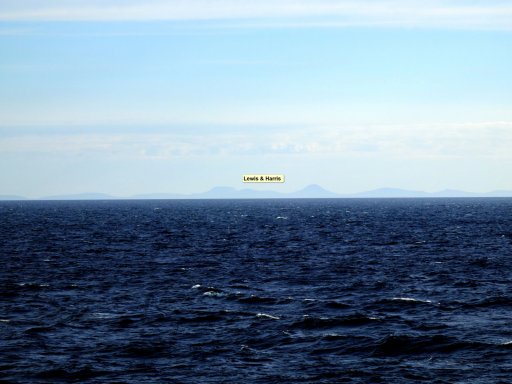
However, when looking North towards Lewis & Harris (70 to 80 miles away), one can clearly see the island which defies all logic. Highest peak is at 2622 feet. The entire island should have disappeared over the horizon.
First photo attached shows Lewis & Harris, Isle of Skye and Rum taken 15 minutes after leaving Castlebay on Barra.

Second photo shows Barra taken from 42 miles away. Can clearly see curvature effect compared to third photo.

I have photos from different ferry positions and panorama videos to prove my point also!
Any clue as to what is going on here?


Took photos and videos whilst traveling from Oban to Barra ferry and vice versa. Height above sea level approximately 50 feet.
Photo's taken over distances up to 80 miles away from observed islands and hills in both the Outer and Inner Hebrides.
Distances calculated from Google Earth.
Interestingly enough, Isle of Barra (facing due West) does indeed recede (as curvature equations would predict) into the sea. Island gradually disappears until major hill peaks can only be seen. Furthest photo is at a distance of 42 miles.
However, when looking North towards Lewis & Harris (70 to 80 miles away), one can clearly see the island which defies all logic. Highest peak is at 2622 feet. The entire island should have disappeared over the horizon.
First photo attached shows Lewis & Harris, Isle of Skye and Rum taken 15 minutes after leaving Castlebay on Barra.
Second photo shows Barra taken from 42 miles away. Can clearly see curvature effect compared to third photo.
I have photos from different ferry positions and panorama videos to prove my point also!
Any clue as to what is going on here?
Attachments
Last edited: