
Rory
Closed Account
In another thread - as well as here - we've been talking again about recreating the Bedford Levels Experiment. A lot of new and useful information has come out: both about the previous experiments, and where they took place, as well as with regard to carrying out a definitive version.
This is my attempt to pull all that together and (hopefully) actually do it, in the summer of 2018 (date to be confirmed).
Note: I went a bit overboard with it, and it got very long. So here's the TL;DR:

And this is what round earth theory predicts:

And never the twain shall meet.
1. A brief history
The Old Bedford River in Cambridgeshire, England has a special place in Flat Earth folklore: it was here, in 1838, that Samuel Rowbotham - the father of modern flat earthism - carried out a series of experiments that he believed proved the earth was flat.
Unfortunately, most of his experiments have been invalidated due to the proximity of his telescope to the surface of the river, where the effects of refraction are strongest.
He did devise one experiment, however, which appears sound in its methodology:

Fig 1. Samuel Rowbotham's 'Experiment 2'
This experiment is basically the same as that carried out by Alfred Russel Wallace in 1870 - equally famous in folklore - although Wallace's experiment used only two markers: a target placed three miles along the river, and a sheet on a bridge, six miles distant, with both those targets and the observer - on another bridge - situated about 14 feet above the water:

Fig 2. Alfred Wallace's experiment
The view obtained through his telescope appeared to show that the middle target was indeed raised on an apparent "hump of water":
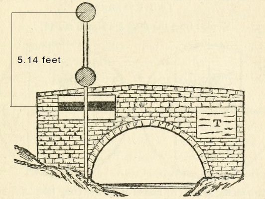
Fig 3. Wallace's observation
Unsurprisingly, both men felt that the results of their experiments supported their own model, while there were problems with both the other man's model and his conclusion.
Notes on these experiments:
In more recent days, a group of modern flat earthers attempted to recreate Rowbotham's original experiment, but failed to show anything of note.
(This is a brief and extremely simplified history: here and here would be good places to start, for more details.)
2. Why the Old Bedford River?
As well as its fame in flat earth circles, the stretch of the Old Bedford River around Welney is probably the longest straight section of uninterrupted inert/near inert water in the UK: a distance of 5.85 miles from the road bridge at Salters Lode (52.5876, 0.3389) to the sluice at Welney (52.521, 0.2527).
Also, it is easily accessible, and the shallow depth of the water, as well as the ability for interested parties to examine the equipment and make their own measurements, makes it a good spot for interactive experimentation.
Note: the section southwest of Welney, towards Welches Dam, which Rowbotham used for several experiments, is also around 6 miles long, but isn't quite as straight; has more trees growing over it; and is now crossed by a railway bridge 3.4 miles from Welney.
Use this link to view a straight line along the full 12-mile stretch.
3. Proposal for a new experiment
Rowbotham's original concept of his 'Experiment 2' is sound; but to improve on the results the observer and the targets should be raised higher, thereby diminishing the effects of refraction.
Also, to best relate the results to a modern audience, the experiment should be recorded with photographs and video.
To begin, the following criteria are established:
4. Methodology
a) The observation points
The sluice gate at Welney, with accessible viewing platform:
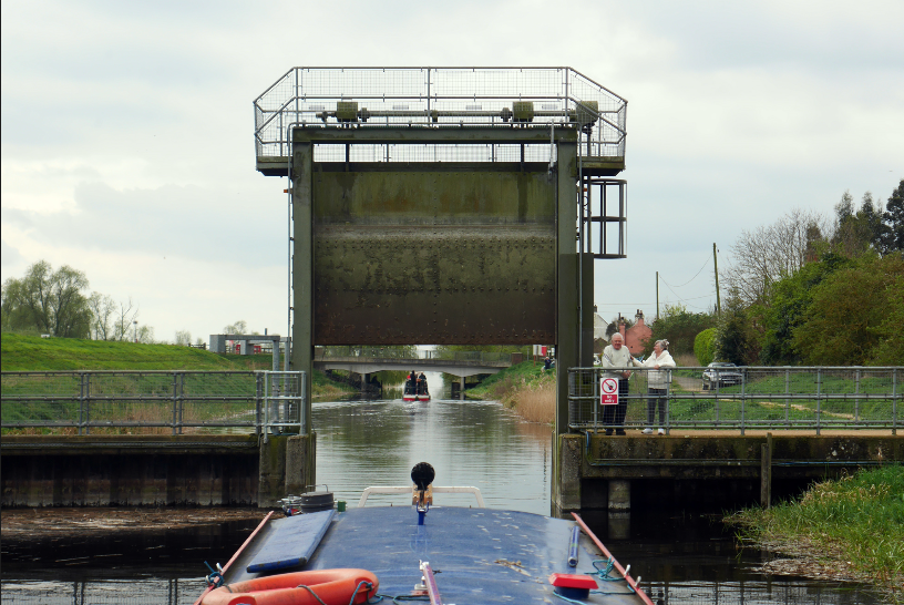
Fig 4. Sluice gate at Welney, looking southwest
The road bridge at Salters Lode:

Fig 5. Unnamed road bridge at Salters Lode, immediately southwest of the 'Old Bedford Sluice'
As the road bridge provides both greater accessibility and elevation above the river, it is proposed that this be the observation bridge - though, if possible, as Wallace did in 1870, observations could be taken from both points.
b) The targets
We will endeavour to place at least three targets a minimum of 10 feet above the water level, and ideally at least 13 feet above the water level, spaced at perhaps 0.1, 2.9, and 5.7 miles from the observer.
The targets will each be placed on top of straight poles sitting perpendicular to the water. For the poles, plastic plumbing pipes have been suggested, such as these 3-metre-long drainage pipes, whose 110mm diameter should provide the necessary stiffness to ensure they remain upright and plumb:

Fig 6. Drain pipe
To achieve the necessary height, the pipes will either be joined together, or smaller (also stiff) pipes inserted into them, in order to extend them.
The pipes themselves will be painted in stripes 12 inches deep, for easy reference, and to verify that the pipes are all identical.
The targets should measure at least 3 feet high and 3 feet wide - whether circular, rectangular, or square - so as to be visible from distance.
Both the road bridge at Salters Lode, and the sluice at Welney, being of measurable heights, can also be used as additional targets.
c) Observation
A Nikon Coolpix P900 should do the trick. Telescopes are also welcome. And if we're lucky with the weather, the naked eye may even suffice.
5. Predictions
Rowbotham's diagrams in the brief history show that different shapes for the surface of the river will produce different results in observation.
For example, if the surface of the river is flat, for an observer at the same height as the targets, all the centres of the targets will appear aligned, like so:
Fig 7. Predicted observation for a flat river (camera at same height as targets)
This cannot happen if the surface of the river is curved, even if the camera/observer is raised, lowered, or tilted. If the surface of the river is curved, for an observer at the same height as the targets, the view will appear like this:

Fig 8. Predicted observation for a convexly curved rived (camera at same height as targets)
Similarly, if the surface of the river is curved, for an observer situated around 6 inches higher than the height of the targets, the middle target will appear higher than the other two:
Fig 9. Predicted observation for convexly curved river (camera raised slightly higher than targets)
And, likewise, this cannot happen if the surface of the river is flat, even if the camera/observer is raised, lowered, or tilted.
This is demonstrated in the 'scale model' video below:
Screenshots:

Fig 10. Flat board showing targets aligned

Fig 11. Curved board showing middle target raised higher (note how it's not possible to tell that the board is curved with the naked eye)
These two mutually exclusive outcomes are one of the simplest ways to confirm the result of the experiment.
To summarise:
6. Further notes

7. In conclusion
Any questions? Any suggestions for improvements? Any feedback from those who doubt that this experiment will demonstrate the shape of the earth's surface?
Obviously Soundly's already done that - but Bedford Levels certainly has its advantages, in terms of allowing all-comers to be involved and take a hands on approach, as well as the considerable historical context.
Feel free to share this with all who may be interested. Perhaps the UK flat earth believers can make the trip to the Cambridgeshire Fens again. Collaborative investigation and discussion would certainly be welcome.
Cheers!")
This is my attempt to pull all that together and (hopefully) actually do it, in the summer of 2018 (date to be confirmed).
Note: I went a bit overboard with it, and it got very long. So here's the TL;DR:
- The Old Bedford River, as well as being famous in flat earth circles, is probably the UK's longest stretch of straight, uninterrupted, near inert water
- This makes it an excellent place for measuring the shape of the Earth, given that the surface of inert or near inert water conforms to the shape of the planet
- Observing three targets placed at the same height above the surface of the water will reveal and confirm that shape
- If the targets all appear to be at the same height, as in Fig. 7, the surface of the river is flat
- If the middle target appears higher than the near and far target, as in Fig. 9, the surface of the river is curved
- Neither of these statements is interchangeable: i.e., if the surface of the river is curved, the three targets can never appear at the same height; and if the surface of the river is flat, the middle target can never appear above the other two (dramatic, unusual, and temporary atmospheric effects notwithstanding)
- The experiment, therefore, is conclusive
And this is what round earth theory predicts:
And never the twain shall meet.
Recreating the Bedford Level Experiment - Proposal
1. A brief history
The Old Bedford River in Cambridgeshire, England has a special place in Flat Earth folklore: it was here, in 1838, that Samuel Rowbotham - the father of modern flat earthism - carried out a series of experiments that he believed proved the earth was flat.
Unfortunately, most of his experiments have been invalidated due to the proximity of his telescope to the surface of the river, where the effects of refraction are strongest.
He did devise one experiment, however, which appears sound in its methodology:
Fig 1. Samuel Rowbotham's 'Experiment 2'
This experiment is basically the same as that carried out by Alfred Russel Wallace in 1870 - equally famous in folklore - although Wallace's experiment used only two markers: a target placed three miles along the river, and a sheet on a bridge, six miles distant, with both those targets and the observer - on another bridge - situated about 14 feet above the water:
Fig 2. Alfred Wallace's experiment
The view obtained through his telescope appeared to show that the middle target was indeed raised on an apparent "hump of water":
Fig 3. Wallace's observation
Unsurprisingly, both men felt that the results of their experiments supported their own model, while there were problems with both the other man's model and his conclusion.
Notes on these experiments:
- Rowbotham's experiment had an observer at 5 feet above the water; this may not have been enough to sufficiently escape the effects of refraction
- As noted by Mick West, Rowbotham only says that his "line of sight fell on the lower part of the larger flag", and not that "it ran across the tops of all the smaller flags"
- There was no independent verification of his experiment
- Wallace, meanwhile suffers from a lack of targets in between the observer and the distant bridge: not only could he have obtained the same view, were the surface of the river flat, if his telescope was somewhat lower than the height of the two targets, but multiple targets make the conclusion all the more clear
In more recent days, a group of modern flat earthers attempted to recreate Rowbotham's original experiment, but failed to show anything of note.
(This is a brief and extremely simplified history: here and here would be good places to start, for more details.)
2. Why the Old Bedford River?
As well as its fame in flat earth circles, the stretch of the Old Bedford River around Welney is probably the longest straight section of uninterrupted inert/near inert water in the UK: a distance of 5.85 miles from the road bridge at Salters Lode (52.5876, 0.3389) to the sluice at Welney (52.521, 0.2527).
Also, it is easily accessible, and the shallow depth of the water, as well as the ability for interested parties to examine the equipment and make their own measurements, makes it a good spot for interactive experimentation.
Note: the section southwest of Welney, towards Welches Dam, which Rowbotham used for several experiments, is also around 6 miles long, but isn't quite as straight; has more trees growing over it; and is now crossed by a railway bridge 3.4 miles from Welney.
Use this link to view a straight line along the full 12-mile stretch.
3. Proposal for a new experiment
Rowbotham's original concept of his 'Experiment 2' is sound; but to improve on the results the observer and the targets should be raised higher, thereby diminishing the effects of refraction.
Also, to best relate the results to a modern audience, the experiment should be recorded with photographs and video.
To begin, the following criteria are established:
a) Inert or near inert water "seeks its own level"
b) The shape of the surface of a body of inert or near inert water conforms to the shape of the Earth
c) The water in the Old Bedford River is "near inert"
d) The shape of the surface of the water in the Old Bedford River, therefore, conforms to the shape of the Earth
e) Targets placed parallel to the surface of the Old Bedford River will conform to the shape of the river
f) These same targets, then, conform to the shape of the earth
g) Measuring these targets will reveal the shape of the earth
4. Methodology
a) The observation points
The sluice gate at Welney, with accessible viewing platform:
Fig 4. Sluice gate at Welney, looking southwest
The road bridge at Salters Lode:
Fig 5. Unnamed road bridge at Salters Lode, immediately southwest of the 'Old Bedford Sluice'
As the road bridge provides both greater accessibility and elevation above the river, it is proposed that this be the observation bridge - though, if possible, as Wallace did in 1870, observations could be taken from both points.
b) The targets
We will endeavour to place at least three targets a minimum of 10 feet above the water level, and ideally at least 13 feet above the water level, spaced at perhaps 0.1, 2.9, and 5.7 miles from the observer.
The targets will each be placed on top of straight poles sitting perpendicular to the water. For the poles, plastic plumbing pipes have been suggested, such as these 3-metre-long drainage pipes, whose 110mm diameter should provide the necessary stiffness to ensure they remain upright and plumb:
Fig 6. Drain pipe
To achieve the necessary height, the pipes will either be joined together, or smaller (also stiff) pipes inserted into them, in order to extend them.
The pipes themselves will be painted in stripes 12 inches deep, for easy reference, and to verify that the pipes are all identical.
The targets should measure at least 3 feet high and 3 feet wide - whether circular, rectangular, or square - so as to be visible from distance.
Both the road bridge at Salters Lode, and the sluice at Welney, being of measurable heights, can also be used as additional targets.
c) Observation
A Nikon Coolpix P900 should do the trick. Telescopes are also welcome. And if we're lucky with the weather, the naked eye may even suffice.
5. Predictions
Rowbotham's diagrams in the brief history show that different shapes for the surface of the river will produce different results in observation.
For example, if the surface of the river is flat, for an observer at the same height as the targets, all the centres of the targets will appear aligned, like so:
Fig 7. Predicted observation for a flat river (camera at same height as targets)
This cannot happen if the surface of the river is curved, even if the camera/observer is raised, lowered, or tilted. If the surface of the river is curved, for an observer at the same height as the targets, the view will appear like this:
Fig 8. Predicted observation for a convexly curved rived (camera at same height as targets)
Similarly, if the surface of the river is curved, for an observer situated around 6 inches higher than the height of the targets, the middle target will appear higher than the other two:
Fig 9. Predicted observation for convexly curved river (camera raised slightly higher than targets)
And, likewise, this cannot happen if the surface of the river is flat, even if the camera/observer is raised, lowered, or tilted.
This is demonstrated in the 'scale model' video below:
Screenshots:
Fig 10. Flat board showing targets aligned
Fig 11. Curved board showing middle target raised higher (note how it's not possible to tell that the board is curved with the naked eye)
These two mutually exclusive outcomes are one of the simplest ways to confirm the result of the experiment.
To summarise:
- If an image can be obtained of the three targets in alignment, as in Figures 7 & 10, the surface of the river is flat
- If an image can be obtained of the middle target raised higher than both the near and far targets, as in Figures 9 & 11, the surface of the river is curved
- If the surface of the river is flat, the observer will be looking neither up nor down at the targets, but perpendicular to local down (i.e., at 0 degrees, or what is colloquially known as "eye level")
- If the surface of the river is curved, the observer will be looking down to the middle target at an angle of 0.0211°, and to the distant target at an angle of 0.0423°
- As the camera nears the surface of the river, the effects of refraction will enable more of the lower part of the distant pole to be viewed than a curvature calculator predicts
6. Further notes
- Tilting the camera does nothing to alter the apparents heights of the three targets, but merely changes their position, as a group, in the frame
- Raising and lowering the camera - as demonstrated in the scale model video above - changes the apparent height order of the targets in the frame, but cannot render the arrangements shown in Figures 7, 9, 10, and 11 true for the opposing model
- Varying levels of refraction are to be expected. For this reason, observations should be made over the course of several days, at different times of day
- Ideally, observations will also be taken at varying heights, including as close to the water as possible, with measurements being made possible by the 1-foot stripes on the poles. This allows not allowing the recreation of Rowbotham's original "Experiment 1", but also shows how refraction changes what is seen as the camera moves closer to the water
- If possible, a mechanism which allows the camera to 'slide' up and down, between the 13 to 14-foot viewpoint and close to the water will be constructed, allowing for continuous filming of the various elevations above the river
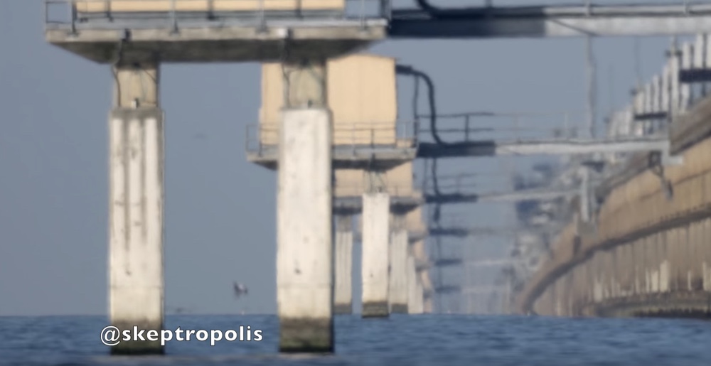
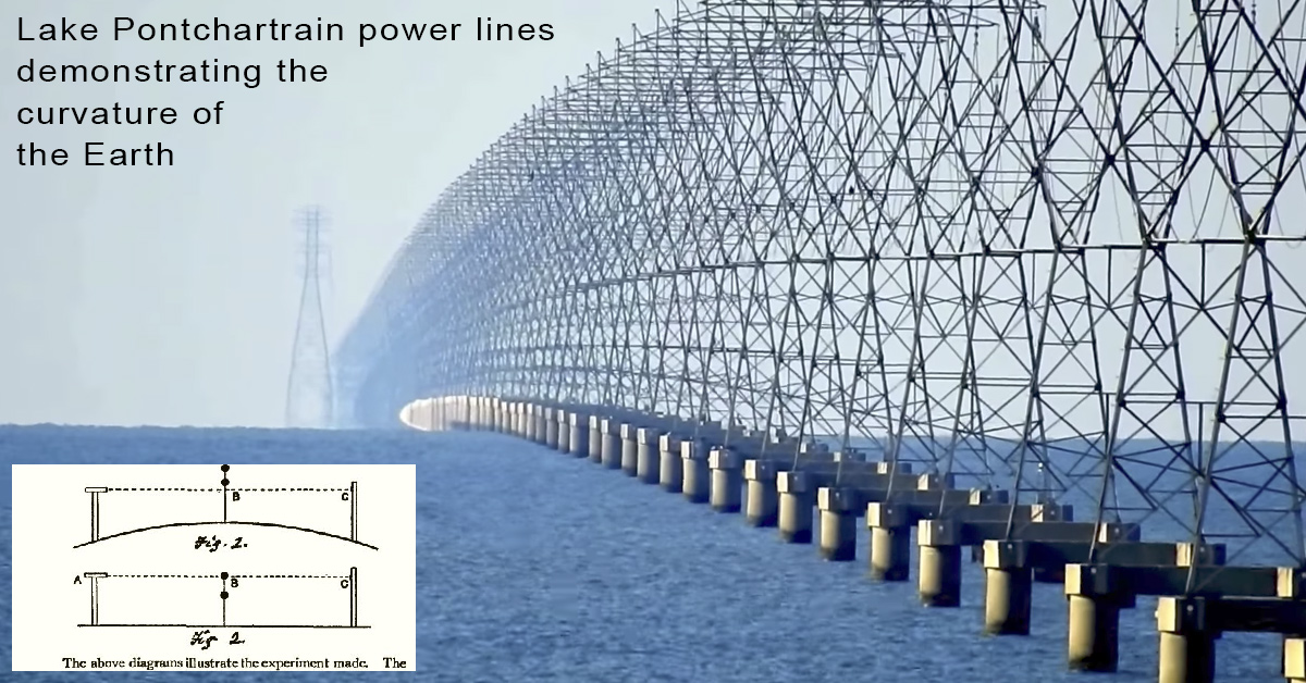
- The same kind of observation has been done at Lake Pontchartrain, Louisiana by YouTube user Soundly. Instead of placing his own targets, he uses marks or structures that are known to be equidistant above the water, such as on the Lake Pontchartrain Causeway, or transmission towers:
Any questions? Any suggestions for improvements? Any feedback from those who doubt that this experiment will demonstrate the shape of the earth's surface?
Obviously Soundly's already done that - but Bedford Levels certainly has its advantages, in terms of allowing all-comers to be involved and take a hands on approach, as well as the considerable historical context.
Feel free to share this with all who may be interested. Perhaps the UK flat earth believers can make the trip to the Cambridgeshire Fens again. Collaborative investigation and discussion would certainly be welcome.
Cheers!
Last edited: