Oroville Dam Spillway Failure

Status
Not open for further replies.
Does a closed thread become invisible to the public or does it become read only?
it will still be visible.

If Mick does decide -at some future point-, to split more sections (of chit chat speculation stuff) out of the thread, so that good information is easier to find, and put those comments into Open Discussion or Rambles, then that information will only be visible to members.


You can also always (for any site) archive pages. https://www.metabunk.org/how-to-lin...hat-might-change-or-vanish.t2252/#post-119930
 
Excellent findings, I think your reasoning is sound. I have just recently been hiking extensively in this exact region, and have walked on the weathered rock there. You can even pick it off with your hands.

The 2nd part of the spillway, before it plunges down, was an unpaved dirt parking lot next to the paved parking lot, and was set aside as an equestrian & horse trailer parking area. Can't understand why it was left umarmored as well.

If it's of any interest to this conversation - the evening of the evacuations, I and many of our neighbors collected together right above the dam, on the south-east ridge (in the grassy area behind the golf course restaurant).

Looking down with a telescope someone had stationed, I was able to see that the fastest amount of water flowing (besides the water pouring into the main spillway) was down the sloping driveway that leads up to the parking lot - it was moving like a river, compared to all the water moving over the spillway.

Others viewed it as well, and we were all quite anxious that this area might continue to gouge and cause the breach. We weren't concerned about the weir itself, as from our end it seemed to be functioning properly. It was the driveway we were worried about, given the huge flow of water going down it.

20170213Ravine999ar.jpg Oroville-dam-2-14-2017-2.jpg 20170213Ravine96.jpg To Scott Gates --

There's a couple good reasons why the weir might not be well attached to the bedrock:

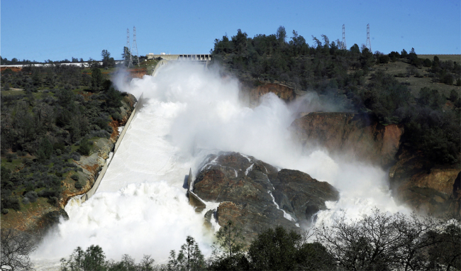
1) The dam operators had reason to believe that the weir would fail within 60 minutes of when they gave their evacuation order. This would indicate that they were observing headwater cutting from surface water or a boil that they considered unstoppable.
"Sunday at 4:42 p.m., when DWR issued this tweet: “EMERGENCY EVACUATION: Auxiliary spillway at Oroville Dam predicted to fail within the next hour. Oroville residents evacuate northward.”
http://www.sacbee.com/news/state/california/water-and-drought/article132361619.html

2) DWR officials were concerned about a boil (water flowing under the weir and coming out of the ground like a spring) coming under the weir.
"DWR officials also hope to reduce the water level by another 50 feet in order to take pressure off the emergency spillway. The level needs to be below the level of emergency spillway in case their is a boil in the weir that is allowing water to leak into the gouge."
http://www.kcra.com/article/evacuation-orders-issued-for-low-levels-of-oroville/8735215

"I understand that is not true," said Ted Thomas, chief spokesperson for the California Department of Water Resources (DWR).
http://www.abc10.com/news/local/verify-are-there-boils-on-the-oroville-emergency-spillway/408761367
20170213_Ravine81.png 20170213Ravine999a.jpg
3) On the evening of the 12th there was one stream running muddy while all the others were running clear. It was the ravine immediately south of the ravine that had cut to near the big weir/parking lot weir interface. See three screenshots from various news videos (photos 2, 3, and 4).
(photos in reverse-order, not sure how to re-sequence them)

4) Obviously, there was no boil, since all erosion stopped when the water stopped coming over the weir. But, that they were worried about a boil indicates that they had limited confidence in the weir footing.

5) The bedrock has vertical weak spots, like this photo shows (pic 1), from immediately below the first section of washed out access road. This weak spot is vertically oriented, and is more than 10' deep. If the engineers in the 1960s cut 10 feet below the surface bedrock to find structural material in this location, they didn't cut deep enough. That slot in the bedrock is at least 15' deep, and appears to have rubble in the bottom.

If this slot was to propagate upstream, it could undercut the weir.

6) If the weir gets undercut, the water coming out the bottom has 60 vertical feet of hydraulic pressure on it. That's much more powerful than the surface water that etched out that weak spot in the first place, and even if the blue bedrock is holding up well to surface runoff and surface pounding, the pressure from 60 vertical feet of water would do more damage than anything that has occurred thus far. Such as etch out laterally at the base of the weir and cause a section of the weir to topple over, thus creating a 30 to 60 foot tall wall of water.

If you figure that the engineers that gave the "60 minutes until uncontrolled release" warning and evacuated 200,000 people had some inside info, then there is a basis for a weak attachment between the weir and the bedrock, and that some observations made late in the day on the 12th would have led them to conclude that weir collapse was very possible. From what I see in the screenshots, it could have been the muddy water emerging from a ravine where all other ravines were issuing clear water, or it could have been the bedrock etching plainly deeper than 10' from the bedrock surface.

I guess I'm saying that I think those engineers in the 1960s were great guys and all, but shortcuts get made sometimes that have negative results down the line.

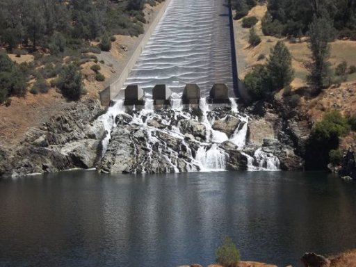
BTW, why does the northern half of the weir have an apron on it, and the southern half not? Haven't heard anyone discuss this. Seems that the designers were more worried about surface erosion on the northern part of the weir...

Source for ravine images:
20 seconds into this 29 second video
http://www.nbcbayarea.com/news/Patc...roville-Dam-Emergency-Spillway-413830443.html

&

http://www.drroyspencer.com/2017/02...eases-emergency-spillway-repairs-in-progress/
 
upload_2017-2-19_8-32-14.png

As an engineer that worked on 25 dams, this photo of the emergency spillway area is all I need to say that officials were correct to evacuate. The rock in this area is clearly susceptible to deep erosion, deeper than the ~ 10 foot foundation of the weir was built to per the plans and description posted here. Tolerating such scour next to the toe of an engineered structure [edit: holding back a lot of water ] is simply not done, either now or in the 1960s. To me, the design simply did not account for this deep erosion.

Indeed, officials didn't think erosion would be this deep:

http://www.latimes.com/local/lanow/la-me-oroville-spillway-failure-20170216-story.html


In a May 2006 filing with FERC, the Department of Water Resources insisted that the emergency spillway was sound.

“DWR recently reviewed the geologic conditions at the emergency spillway and concluded that the spillway is a safe and stable structure founded on solid bedrock that will not erode,” the department stated. “The Project Geology Section determined that there are only one to four feet of erodible top soil in the downstream area and that erosion would not compromise the stability of the emergency spillway.”
Content from External Source
I am not accusing the designers, indeed:


DWR spokeswoman Nancy Vogel said, “We don’t know the cause of the spillway erosion and we won’t know the cause until we get experts in there to do a full investigation and analysis.”

John France, a veteran dam safety consultant with Aecom, noted, “In 1968, quite frankly, there weren’t probably a lot of methodologies available to evaluate how rock erodes if you had flowing water on it.”
Content from External Source
The science of using rock on emergency spillways has evolved a lot since the 1960s.

Edit: I can also say that the rock doesn't "look" like it would erode as bad as it did. There will likely be a few papers that come out of this that advance the state-of-the-art.
 
Last edited:
As an engineer that worked on 25 dams, this photo of the emergency spillway area is all I need to say that officials were correct to evacuate. The rock in this area is clearly susceptible to deep erosion, deeper than the ~ 10 foot foundation of the weir was built to per the plans and description posted here. Tolerating such scour next to the toe of an engineered structure is simply not done,
well in fairness that wall behind him is the built up stuff under the road. certainly deeper than 4 feet though.

and the hole near the weir is pretty deep too.

1050661464.jpg

Oroville-Dam-gouge-1.jpg

C4km2HiWcAE9KzK.jpg
 
I think that as a "current event" thread, this thread has run its course. Metabunk is about providing useful information for people, explaining things, and debunking falsehoods.

The thread is too long to fulfil that function, and has now become a conversation focused on minutia and speculation.
Even after you split the detailed discussions on minutia and speculation into four other threads already.
 
Herb - I think that rock that you mention at the bottom of the Flood Control Spillway didn't roll there but emerged when the surrounding soil was eroded away.

After looking at A LOT of photos, I think you are right in that the rock was there to begin with. A slightly different perspective makes a big difference on what it looks like. Also, it's hard to comprehend the massive size of the whole dam and all its separate parts. The slant of the rock stratas (?) in the two photos sort of decided me because what are the odds it would roll down and end up orientated the same way? That doesn't necessarily preclude that it didn't slide down from somewhere else, but I do think you are right, it was there in that position all the time. It will be interesting to see that hillside once they shut off the spillway.


1.) There was no boil. When first notices the erosions was moving fairly rapidly, back cutting toward the weir. That said numerous media reports identified the authorities quickly noting, just after the evac order was given, thet the back cutting had slowed significantly or stopped - which is totally consistent with scour of weak weathered surface materials.

This is a good example of the problem of long thread. about a thousand posts upthread there was a series of posts where it was determined that the "boil" being referred to was a whitewater boil (a region of transition of the water from the general downstream flow to a highly turbulent flow due to an obstruction or direction change) , and not a levee boil. This useful information is now basically lost, and we get repeated discussion speculating on levee boils when it's really just a conflict of terminology - the spillways folk's speech being misinterpreted by flatlanders.

And just yesterday I had to delete an extensive post by someone explaining his theory of how the road was lower than the spillway and that would lead to dam failure.

So we've got lots of useful information in the thread. It's just getting lost, and people are burying it further with repeated speculation.

I'm going to leave the thread open for a few days. however I encourage people who wish to stay to consider how they might create something useful from this - i.e. focussed summaries of single topic material in the thread which they are particularly familiar with, in a new single topic thread.

Now go look at the 20 new and intersting photos from DWR:
http://pixel-ca-dwr.photoshelter.co...yfg/G00003YCcmDTx48Y/Oroville-Spillway-Damage
 
well in fairness that wall behind him is the built up stuff under the road. certainly deeper than 4 feet though.

and the hole near the weir is pretty deep too.

1050661464.jpg

Oroville-Dam-gouge-1.jpg

C4km2HiWcAE9KzK.jpg

Yes, I believe the yellow dots in your second photo are people, and based on other photos, that hole is 20-30 feet deep and frighteningly close to the toe. It is also close to the odd abrupt transition between the parking lot weir and the ogee weir. The resistance of the bedrock to erosion in that area is especially critical.

Abrupt transitions like that are no longer done, and if any reengineering of the weir is eventually conducted (trust me, it will be), that area is most likely to receive an upgrade.
 
Back on Monday, in post 345 concerning 'operating rules' of the dam, https://www.metabunk.org/oroville-dam-spillway-failure.t8381/page-9 under ''Limitation on releases" it says "C. Releases from Oroville dam are not to be increased more than 10,000 c.f.s nor decreased more than 5,000 c.f.s in any 2-hour period." (I'm assuming it's the main spillway they are referring to)

An increase from 0 cfs to 100,000 cfs should take about 20 hours and a decrease back to 0 should take about 40 hours according to that. I don't believe they followed a schedule even close to that, but I could be wrong.

The rules didn't state why that schedule should be followed. I wonder if it's to allow the temperature of the spillway to gradually adjust to avoid creating cracks.
Content from External Source
Apparently during the emergency they didn't follow that procedure. Went from 55,000 cfs to 100,000 cfs in less than 3 hours, maybe 1 or 2.

02/12/2017 15:00 54904
02/12/2017 16:00 65117
02/12/2017 17:00 0
02/12/2017 18:00 99969


http://cdec.water.ca.gov/cgi-progs/queryF?s=ORO&d=12-Feb-2017+16:07&span=25hours
http://cdec.water.ca.gov/cgi-progs/queryF?s=ORO&d=13-Feb-2017+17:07&span=25hours

Thanks for the release data.
I can't blame them for not following the rules in the situation they're in, it's hardly possible. I still wonder if they didn't cause the problem to begin with though.

Does anyone know why the rules limit the releases, as posted above?

I went back a month or so on the releases and nothing seemed too out of line. They do interpret the limitations differently than I would. I would tend to think it meant to ramp up the release over a two hour time frame whereas they tend to open the gates to more or less immediately allow 10,000 cfs more flow and then wait two hours and repeat, which is probably fine.

There's a bit of an anomaly in the outflow releases which I wonder about, right at what I guess is the beginning of the main spillway problem.

02/07/2017 09:00 47569 Everything's kosher up to here

02/07/2017 10:00 -----? This is the only place I've seen where the relevant data is missing

02/07/2017 11:00 57545 They're up 10,000cfs now (In two hours, so on schedule)

02/07/2017 12:00 30009 They've discovered the problem and are ramping down way faster than the rules normally allow

02/07/2017 13:00 5420 They are shut down

02/07/2017 14:00 5153 etchttp://cdec.water.ca.gov/misc/flaglist.html

It seems odd the data is missing from within two hours before the problem is discovered.

Again, does anyone know what the reasoning is behind the "Limitation on releases" ?


This is a good example of the problem of long thread. about a thousand posts upthread there was a series of posts where it was determined that the "boil" being referred to was a whitewater boil (a region of transition of the water from the general downstream flow to a highly turbulent flow due to an obstruction or direction change) , and not a levee boil. This useful information is now basically lost, and we get repeated discussion speculating on levee boils when it's really just a conflict of terminology - the spillways folk's speech being misinterpreted by flatlanders.

And just yesterday I had to delete an extensive post by someone explaining his theory of how the road was lower than the spillway and that would lead to dam failure.

So we've got lots of useful information in the thread. It's just getting lost, and people are burying it further with repeated speculation.

I'm going to leave the thread open for a few days. however I encourage people who wish to stay to consider how they might create something useful from this - i.e. focussed summaries of single topic material in the thread which they are particularly familiar with, in a new single topic thread.

Now go look at the 20 new and intersting photos from DWR:
http://pixel-ca-dwr.photoshelter.co...yfg/G00003YCcmDTx48Y/Oroville-Spillway-Damage

Thank you Mick, Deirdre and anyone else behind the scenes for providing this thread. Your attention to detail and even handedness are to be commended. I certainly learned a great deal more than I expected to when I first joined and I will be exploring the rest of the forum with interest. To readers- we seem to have entered a period where fake news is easier to get and it's incumbent on the rest of us to be informed and to call it out whenever we see it. Thanks again. DT
 
There has been some great info provided in this thread. ...Not all the speculation about rock..., but the plans to the dam facilities and erosion plans, topographical maps etc.
I'm really sorry you feel this way about the speculation on the rock. The failure is my inability to concisely describe the very challenging science of geology in terms that can be understood by those untrained in the art. [I feel] The underlying cause of the original failure is the geology, and the underlying cause of the fear of the integrity of the emergency spillway that led a hundred thousand people to be evacuated is the geology. I based my speculation on the identification of rocks by the experts as I'd cited. I've cut my teeth on the Josephine ophiolite, and simply wanted to share that knowledge, considering that the dam is built into the smartville ophiolite.
 
Last edited by a moderator:
Also, just in general, it seems to be poor planning to have no road access to the other side of the dam other than across an unlined emergency spillway. A heavy equipment capable road from the valley floor would have been handy. I know this because I have excellent hindsight concerning other peoples problems.

I'm sure they probably have some security cameras on the location, but do they have any that specifically monitor the condition of the dam itself? How about other sensors? Flashing lights and sirens?They should also make a note to always have a camera equipped drone or two at all facilities like this. Considering places like this, which are gigantically expensive to build, marvelously expensive to run, and catastrophically disruptive even with just partial failure, it would seem prudent to have monitoring capabilities like above, especially considering they are (warning, warning, crappy pun ahead) dirt cheap and damn inexpensive.
 
The failure is my inability to concisely describe the very challenging science of geology in terms that can be understood by those untrained in the art
No the failure is you are making guesses (which is fine) and speaking as if they are fact. ex: it doesnt matter what we can see and wehre we can see it, the fact is we cannot see what the weir is standing on. So making statements that (for ex) the bedrock under the weir is no good is bunk.

and... how were you trained in the art again?
 
I'm really sorry you feel this way about the speculation on the rock. The failure is my inability to concisely describe the very challenging science of geology in terms that can be understood by those untrained in the art. The underlying cause of the original failure is the geology, and the underlying cause of the fear of the integrity of the emergency spillway that led a hundred thousand people to be evacuated is the geology. I based my speculation on the identification of rocks by the experts as I'd cited. I've cut my teeth on the Josephine ophiolite, and simply wanted to share that knowledge, considering that the dam is built into the smartville ophiolite.

Geology is NOT A SCIENCE!!- Sheldon Cooper, esteemed (in his own mind) Nobel Prize winning theoretical physicist
 
This is a good example of the problem of long thread. about a thousand posts upthread there was a series of posts where it was determined that the "boil" being referred to was a whitewater boil (a region of transition of the water from the general downstream flow to a highly turbulent flow due to an obstruction or direction change) , and not a levee boil. This useful information is now basically lost, and we get repeated discussion speculating on levee boils when it's really just a conflict of terminology - the spillways folk's speech being misinterpreted by flatlanders.

And just yesterday I had to delete an extensive post by someone explaining his theory of how the road was lower than the spillway and that would lead to dam failure.

So we've got lots of useful information in the thread. It's just getting lost, and people are burying it further with repeated speculation.

I'm going to leave the thread open for a few days. however I encourage people who wish to stay to consider how they might create something useful from this - i.e. focussed summaries of single topic material in the thread which they are particularly familiar with, in a new single topic thread.

Now go look at the 20 new and intersting photos from DWR:
http://pixel-ca-dwr.photoshelter.co...yfg/G00003YCcmDTx48Y/Oroville-Spillway-Damage

Thank you, Mick. As a resident that lives directly below and in line sight of the dam (and spillway) by only a few miles, I was extremely appreciative to find this forum thread which gave me better than average useful information about the situation. I was happy to learn the difference between competent and weathered bedrock and the basics of the construction of the E spillway and the few different theories as to the original failure of the main spillway (leaking drain tubing, cavitation and water hammering, etc.). I was also happy to be directed to sources of more extensive information if I was inclined to pursue it.
However, just as you have pointed out, the discussions became way too technical (more than a layperson needs in order to have a useful understanding of the issues), and then just the back and forth speculations and argument over whether or not the original builders were sufficiently aware of or concerned with the nature of the foundation of the weir. There was some total, what I think of as "Titanic Syndrome" exhibited which, at least for me, was not at all helpful. So I appreciate your shutting down or at least curtailing all this long-winded minutia.

What I need now is factual and knowledgeable information that helps me stay as informed as possible so that I can realistically assess the possible ongoing danger, presented mostly, it seems now, by the damaged main spillway (if water level again approaches possible use of the E spillway, I am getting out of harm's way) and it's possible continued erosion upward or southward.

Again, I thank you and everyone that has provided information and considered opinion here, it has definitely served to help me remain relatively calm and focused.
 
this has been a great place to get information, thanks, Mick.

Flooding in California is a ongoing interest for many, the FLood Plain Management Assoc., for example. http://www.floodplain.org/sacramento

Everyone living along these levees knows what a boil is and the problems they cause. When things went haywire with the emergency spillway, they used the term to convey the urgency of the problem. There was no time for pedantic nuances.

-Joe
 
By todays design standards aren't armored emergency spillways suppose to include underdrains so cement cracking later on doesn't cause cavitation? If that's true why is the DWR pouring tons of concrete without drains? Do you think they are trying to hide something wrong with the rock the entire area is built on?
 
Back on Monday, in post 345 concerning 'operating rules' of the dam, https://www.metabunk.org/oroville-dam-spillway-failure.t8381/page-9 under ''Limitation on releases" it says "C. Releases from Oroville dam are not to be increased more than 10,000 c.f.s nor decreased more than 5,000 c.f.s in any 2-hour period." (I'm assuming it's the main spillway they are referring to)

An increase from 0 cfs to 100,000 cfs should take about 20 hours and a decrease back to 0 should take about 40 hours according to that. I don't believe they followed a schedule even close to that, but I could be wrong.

The rules didn't state why that schedule should be followed. I wonder if it's to allow the temperature of the spillway to gradually adjust to avoid creating cracks.
Content from External Source

Hydraulic systems demonstrate a principle known as "Water Hammer."

If you have a running flow and you immediately shut down, or close, that flow the system will experience the hydraulic shock associated with the inertia of all of the water in the column that was flowing toward the point of closure.

You can sometimes experience this water hammer effect with household plumbing. But household plumbing represents a minimal flow in contrast to the 1,000's of cubic feet per second flowing through the flood control structure.
 
Yes, I believe the yellow dots in your second photo are people, and based on other photos, that hole is 20-30 feet deep and frighteningly close to the toe. It is also close to the odd abrupt transition between the parking lot weir and the ogee weir. The resistance of the bedrock to erosion in that area is especially critical.

Abrupt transitions like that are no longer done, and if any reengineering of the weir is eventually conducted (trust me, it will be), that area is most likely to receive an upgrade.
Regarding the parking lot wall section, I'm a little surprised that they haven't added a sand bag wall on top of it. It seems to me like it's much less well prepared for flow vs the emergency weir section, and it would be a fairly simple task to raise it if they thought that would help. Maybe they think the increased width (and therefore less flow per width) is important in the case of more use.
this has been a great place to get information, thanks, Mick.

Flooding in California is a ongoing interest for many, the FLood Plain Management Assoc., for example. http://www.floodplain.org/sacramento

Everyone living along these levees knows what a boil is and the problems they cause. When things went haywire with the emergency spillway, they used the term to convey the urgency of the problem. There was no time for pedantic nuances.

-Joe
I disagree regarding being pedantic. It's important to use the right term, to avoid causing even more panic.
 
I'm really sorry you feel this way about the speculation on the rock. The failure is my inability to concisely describe the very challenging science of geology in terms that can be understood by those untrained in the art. [I feel] The underlying cause of the original failure is the geology, and the underlying cause of the fear of the integrity of the emergency spillway that led a hundred thousand people to be evacuated is the geology. I based my speculation on the identification of rocks by the experts as I'd cited. I've cut my teeth on the Josephine ophiolite, and simply wanted to share that knowledge, considering that the dam is built into the smartville ophiolite.

BLUE GREY 19-02-2017 1-45-15 PM.jpg


Rock Whisperer

I was going to post this to the thread but given your knowledge of the Josephine ophiolite I thought I would direct it to you.

This is a screen grab of an image recently posted at the following URL:
http://pixel-ca-dwr.photoshelter.co...yfg/G00003YCcmDTx48Y/Oroville-Spillway-Damage

The image shows an erosion cut in the apron immediately below the auxiliary spillway. The rock in the cut appears to be composed of the blue grey rock and consensus opinion on the site appears to be that this rock is competent. There is a small mountain of it at the mouth of the Flood Control Spillway which has sustained a hammering from the 100 k CFS release and it is still standing.

Question for the geologists:
The rock in the image appears to be the same quality of rock. The rock at the FCS mouth shows minimal erosion under heavy scour. The rock in the image shows significant scour after much lower flows for a much shorter period. Does this grade of rock also exhibit significant variation from one location to another?
 
There has been some great info provided in this thread. ...Not all the speculation about rock..., but the plans to the dam facilities and erosion plans, topographical maps etc.

I'm having a hard time finding any of that good, solid bedrock they supposedly mounted the weirs on in the latest pictures, Deirdre. All the evidence we have so far shows all the rock nearly everywhere on the e-spillway slope is not 'solid'. I would humbly suggest that - based on the evidence we see so far - you (and certainly Scott Gates) are speculating that the weir foundation must be solid because the engineers would have made sure to mount it on solid, competent bedrock. You and Scott may be right, but you have provided no clear evidence of that.

I see plenty of un-weathered blue-green rock in the pictures, but that rock all seems plenty fractured and subject to erosion itself. It's less susceptible to erosion than the highly-weathered orange-red rock on top, but you really couldn't call this 'solid bedrock' simply because of the blue-green color. It's fractured. It's subject to erosion. It doesn't look solid enough for a competent sill-on-rock construction for reliably holding back the 'parking lot' water when faced with serious downstream-side erosion and potential undercutting. The current dam engineers apparently agree and thought to evacuate 200,000 people. Were they just speculating?

This is all evidence of a serious structural problem with the weir and its foundation - it's not merely 'speculation'. Were is there evidence (pictures or otherwise) of your or Scott's claim that the foundation is sound and not an issue?

4485.png 4490.png 4532.png 4551.png
 
I would humbly suggest that - based on the evidence we see so far - you (and certainly Scott Gates) are speculating that the weir foundation must be solid because the engineers would have made sure to mount it on solid, competent bedrock
No i'm not. But i'm not saying that rock 500' away is indicative of whats under the weir either. And documentation was presented that they went down an unanticipated 10 feet to find good bedrock. I'm not digging through 200 posts to find that link again though.

And.. whether you think i am speculating (i have no solid opinion on the bedrock weir issue) or you are speculating.. we are ALL speculating is my point. so why are you rehashign the same old speculative arguement,, yet again.
 
Last edited:
Hydraulic systems demonstrate a principle known as "Water Hammer."

If you have a running flow and you immediately shut down, or close, that flow the system will experience the hydraulic shock associated with the inertia of all of the water in the column that was flowing toward the point of closure.

You can sometimes experience this water hammer effect with household plumbing. But household plumbing represents a minimal flow in contrast to the 1,000's of cubic feet per second flowing through the flood control structure.
Is water hammer a problem in an open channel? It's absolutely a problem in a pipe, but in an open channel I thought the velocity of the water led to an increase in surface height rather than a pressure spike. Then again, it's been a while since my water classes.
 
The thread will remain open for a few days. However I ask that people restrict their posts to significant new information. Please refrain from long posts speculating about the precise nature of things. If you don't actually have any information then you might as well wait and see. This is not a contest to see who comes up with the best guess.

So unless you post adds something other than your informed guesses then please consider carefully if it's signal or noise.

Posters who continue with lengthy speculations will be removed from the thread.
 
This is a final warning. Anyone who posts speculation in this thread without evidence will be removed from the thread. Anyone who posts long essays will be removed.

Keep it to concise information, preferably with pictures and/or numbers. If it requires a long explanation it's either not important, or it needs a new thread.
 
The "fractures" are chill margins. As the magma forces its way through, the sides cool quicker due to the cooler rock. This leads to smaller mineral grains forming on the edges than the center of each individual sheet of rock as its emplaced.

So weaker zones that are prone to fracture under stress, even though they may not be physically fractured yet. In the pictures, we're looking at what happens to the chill margins in the blue-green bedrock after they are placed under stress by folding, weathering, hydro-thermal venting or erosion.

With regards to hydro-thermal venting and rock color, is there any significance to the colors, rock whisperer? I mean, are the mineral deposits from such venting always 'orange' like weathered rock (at least in these formations in Oroville)? Is there some subtle differences in weathered rock color than hydro-thermal deposits that mere mortals could discern? I assume where the orange and blue-green rock are clearly banded, then this was the result of venting at one time and not surface weathering.

And is the blue-green rock here part of the dike complex, or is it the plutonic rock itself? Probably better asked if plutonic rock is always 'solid' and rock with chill margins would be dike complex rock? The importance being that some blue-green rock could be plutonic and some dike complex - is that possible?
 
Last edited:
The LA times published this a few days ago:
http://www.latimes.com/local/lanow/la-me-oroville-dam-cause-spillway-20170216-story.html

A summary of the incident, prepared by state water officials four days after the crater in the concrete chute appeared, said water from heavy rains hit the hillsides where the massive concrete spillway runs.

Flowing water during heavy rains was “diverted ... effectively eroding and undermining the spillway, causing a section to collapse,” said the incident summary.
Content from External Source
Report (Feb 15) attached, but seems not to match that exactly:

A spillway located at the Oroville Dam was compromised
during heavy rains. Flowing water was diverted toward the
adjoining hillsides, effectively eroding and undermining
the spillway causing a section to collapse. At
0738(02/11/17) water crested over the auxiliary spillway
and began to flow causing minimal erosion to the hillside
as expected.
Content from External Source
Notice it does not say that heavy rains were diverted, it says flowing water. The sequence of events suggested in the report is not clear. Is the LA times reading too much into it? Has DWR said anything similar elsewhere?
 

Attachments

  • Oroville-Dam-Spillway-Incident-Status-Summary.pdf
    158.6 KB · Views: 1,323
At this point there is no other choice but to armor that hillside as much as possible. But there was a high quality aerial photo of the main spillway just prior to the concrete being poured. It showed the rock it was built on. Half of the rock had an orange hue. This photo has since disappeared. The only place I could have seen it was on the DWR website. So yes, things are being hidden from our view.

Does it make sense that the DWR gets to select the members that will be the independent review consultants.
Not to disparage any of the 5 new members since I don't know who they are, but doesn't this just mean that the new BOC is beholden to the DWR for their new jobs? Isn't that a conflict of interest? Or is this just a new layer of Bureaucracy? Is my pessimism showing?

https://www.ferc.gov/media/statements-speeches/lafleur/2017/P-2100-02-13-2017.pdf


And last page:

Sorry I didn't mean to attach all those files. Please delete them as people can follow the link to see the document in whole.
 
Last edited:
that will be the independent review consultants.
what you posted there (didnt click and read your attachments) doesnt sound like an "investigative" committee. Meaning to investigate possible negligence, erosion issues etc associated with the cause. It sounds to me like that just applies to 'fixing it'.
 
Hydraulic systems demonstrate a principle known as "Water Hammer."

If you have a running flow and you immediately shut down, or close, that flow the system will experience the hydraulic shock associated with the inertia of all of the water in the column that was flowing toward the point of closure.

You can sometimes experience this water hammer effect with household plumbing. But household plumbing represents a minimal flow in contrast to the 1,000's of cubic feet per second flowing through the flood control structure.
Is that possible in an open to the atmosphere system like this spillway? That would imply regular rivers could experience water hammer...?
 
I have a standing offer of a free beer to whoever can find that photo. It does exist, or did, as I saw it before the emergency spillway began to flow last week. Now it is missing from the internet . . . I don't mean to point fingers, but DWR is in damage control mode.
This has happened to me before when hunting for images to add to MB, and in my humble opinion (and humbler experience) it doesn't always mean there's damage control or some kind of coverup going on. Sometimes images just go down. Here at MB we get a lot of theories about 'damage control' or, worse, 'coverups' from government agencies in events like this, and most the time they end up being unfounded.
 
BLUE GREY 19-02-2017 1-45-15 PM.jpg

This is a screen grab of an image recently posted at the following URL:
http://pixel-ca-dwr.photoshelter.co...yfg/G00003YCcmDTx48Y/Oroville-Spillway-Damage

The image shows an erosion cut in the apron immediately below the auxiliary spillway. The rock in the cut appears to be composed of the blue grey rock and consensus opinion on the site appears to be that this rock is competent. ...

Notice the slopes are toward that area, which indicates that historically there has been a weak point there.
 
Possible weakened bedrock layer dipping towards weir.
weak layers dipping toward weir.jpg

My cross-section of how weak layers directly downstream of the emergency spillway can extend under the weir due to the layers dipping steeply to the NW.
DSCN2697.JPG
(not to scale)
 
Is water hammer a problem in an open channel? It's absolutely a problem in a pipe, but in an open channel I thought the velocity of the water led to an increase in surface height rather than a pressure spike. Then again, it's been a while since my water classes.

Bolding added.

It is the pressure spike that causes the increased water height.
When the flow is interrupted there is considerable inertial force due to the velocity of the flow.
That force will first act on whatever caused the obstruction in the flow.
If the obstruction has sufficient mass then the pressure spike will result in an increase in water height. Essentially all the water in the column heading toward the obstruction "pushes" the water up.

The open and closed channel question is an interesting one. The Flood Control Structure is built as a series of 8 short tunnels leading to the outflow gates at the head of the main spillway

The hydraulic modelling performed to verify the engineering design of the spillway found that there were problems with water flow separation due to hitting the roof of the water channel within the Flood Control Structure. This lead to a redesign of the Flood Control Structure resulting in the addition of a back wall that is visible in images of the structure taken from the parking lot. At the 901 foot height of the ogee weir the level water is about halfway up this wall. This wall was found to greatly improve the water flow to the gates.

This implies that the channel within the structure is, at certain reservoir heights, functionning as a submerged closed channel and therefore any pressure spike would be applied to all of the constraining surround. Would not trust my calculations of the resulting hydraulic pressure but at 100 k cfs it will be significant.

The following document makes interesting reading:
https://www.usbr.gov/tsc/techreferences/hydraulics_lab/pubs/HYD/HYD-510.pdf
 
Status
Not open for further replies.
Back
Top