Oroville Dam Spillway Failure

Status
Not open for further replies.
That's the road over the dam, isn't it? It certainly looks like it's capable of two-way traffic.

And a lot of weight as well.

I'm guessing that the whole Oroville situation has kind of fallen off the news cycle and KCRA is no longer sending their helocopter. Without that news helicopter the high quality images of work have dropped off to nearly zero other than the few photos a day the DWR provides. With that shot from the DWR of the concrete trucks I imagine that every rock placed on the spillway must be well on the way to being cemented in place by now.

Searching for other images mostly leads to "bunk" that this site is out to address.

Perhaps yet another thread for images?
 
There's a painting of the dam at the visitor center

Respectfully, painting is art, not science, and has no place in this technical discussion.

I love art, and wouldn't want to live in an world without a lot of it; but there is an abundance of technical drawings and photography on this project to overwhelm the viability of an artistic illustration. The problem is, after all, a technical one :)
 
The use of helicopters to me indicates they are in full speed ahead every method possible frame of mind. It is risky to run helicopters over ground crews. It is very risky to fly helicopters below the altitude they can safely initiate an autorotation maneuver if they lose power (though the UH-60 is twin engine specifically for that military requirement).
UH60autorotationenv1.jpg

This shows that at the altitudes and speeds the helicopters are working they have little chance at choosing any landing area and very little ability to flatten then reverse the pitch on the blades, drop the suspended cargo if present, drop altitude and use that to accelerate the rotors then increase pitch on the blades and flare for a landing. Flying low and slow in a helicopter is its most vulnerable position.

The insurance for this, I am not sure how that works but helicopter and construction sounds incredibly expensive to me.

Can anyone confirm or deny these admittedly non expert opinions?

The circumstance you are describing is known as "dead man's curve." Its name derives from the fact that at those speeds and feeds you run out of options PDQ. You don't want to operate there.
 
There is probably a bridge engineer some where going .. whoa, whoa .. there are how many fully laden cement trucks going over and parked on the cement bridge directly above the main spillway per hour ?

"A lot".

Wait, let me get this straight, there is only one semi-operable way to let water out of the bathtub, the main spillway, correct ?

"Yes".

They are trying to shore up the base of auxiliary spillway with TONS of concrete and rock, correct ?

"Yes".

Why not fly material in and take the burden off the bridge above the only semi-functioning Res drain?
 
#OrovilleDam team dedicated to searching social media controlling message! #censorship must stop! Young man fired for posting this photo


The Department of Water Resources hires a contractor to work on the dam. The contractor hired was Syblon Reid.


This contractor has a strict “No social media, no photos policy” at every site they work on.

Some of the employees did not abide by their contract and posted pictures of the Oroville Dam emergency spillway online which is why five people were released. http://kron4.com/2017/02/18/5-oroville-dam-workers-fired-after-posting-pictures-on-social-media/
Content from External Source


KCRA 3 also learned Thursday that 15 construction crew members were terminated from the job this week.

Five were fired after they failed a drug test, five others were terminated for posting on social media from the worksite -- which is forbidden -- and five others were let go because they were found to be unqualified for the job, DWR spokesman Chris Orrock said. http://www.kcra.com/article/officials-dispel-rumors-surrounding-lake-oroville-evacuations/8946030
Content from External Source
 
Last edited:
There is probably a bridge engineer some where going .. whoa, whoa .. there are how many fully laden cement trucks going over and parked on the cement bridge directly above the main spillway per hour ?

"A lot".

Wait, let me get this straight, there is only one semi-operable way to let water out of the bathtub, the main spillway, correct ?

"Yes".

They are trying to shore up the base of auxiliary spillway with TONS of concrete and rock, correct ?

"Yes".

Why not fly material in and take the burden off the bridge above the only semi-functioning Res drain?

I have some doubts about the gatehouse for this much water noticing a few trucks and rocks. Not sure, interesting point worth considering, but I imagine that structure is not just solid but 1950's atomic bomb proof.
 
And we should all remember that this reservoir is an integral part of a state water control project which provides both flood control, and water availability (and electricity). Flood control prevents taking the primary spillway out of commission for an extended period and letting the emergency spillway retard (incapable of "control") the flood. Water provisioning prevents draining the reservoir so that the primary spillway can be dry for several months.

Snowpack in the watershed is far above normal at this late stage of the season, so there's plenty of water available. But it's not easy to predict the demand for it over the next several months since so much of that demand is agricultural and seasonal precipitation forecasts have variable consistency and confidence.

I can understand "water availability" when we're talking about maintaining a minimum height, so that a minimum river flow can be maintained. But is that really a consideration in the middle of the rainy season when everything downstream is already flooded? I would think maximum insurance against overflowing the emergency spillway again would be the primary concern. They have a couple months yet to let the reservoir storage recover, if they choose.

What are they going to do when they have to spend months (or years?) repairing the main flood control spillway? If it goes through a rainy season, wouldn't they be almost forced to draw the level down to where they can contain nearly an entire winter's worth of water?

Actually, the plan going forward for how the repairs will be managed is every bit as fascinating to me as the current situation. A billion dollars? Not sure I see how that's possible. They won't be rebuilding the gates, just the spillway. Years? I don't see how they could afford that without ending up having to use the emergency spillway or some newly constructed diversion.
 
The Department of Water Resources hires a contractor to work on the dam. The contractor hired was Syblon Reid.

Warning, escape routes lack by Oroville Dam
This contractor has a strict “No social media, no photos policy” at every site they work on.

Some of the employees did not abide by their contract and posted pictures of the Oroville Dam emergency spillway online which is why five people were released. http://kron4.com/2017/02/18/5-oroville-dam-workers-fired-after-posting-pictures-on-social-media/
Content from External Source

KCRA 3 also learned Thursday that 15 construction crew members were terminated from the job this week.

Five were fired after they failed a drug test, five others were terminated for posting on social media from the worksite -- which is forbidden -- and five others were let go because they were found to be unqualified for the job, DWR spokesman Chris Orrock said. http://www.kcra.com/article/officials-dispel-rumors-surrounding-lake-oroville-evacuations/8946030
Content from External Source

I saw that posted elsewhere. Firings for failed drug tests and lack of qualifications, I can understand. But the bit about social media seems to me the sort of thing this site debunks, rather than repeats. Wouldn't most (or all?) of the people onsite doing construction be subcontractors? It's not quite so easy getting a subcontractor to fire an employee for violating some (arbitrary) provision of the contract.

I'm new here, so maybe I don't understand the protocol. But I'm a bit skeptical that this actually happened. Or maybe that was the point of the post I quoted. Conspiracy theory?
 
Respectfully, painting is art, not science, and has no place in this technical discussion.

I love art, and wouldn't want to live in an world without a lot of it; but there is an abundance of technical drawings and photography on this project to overwhelm the viability of an artistic illustration. The problem is, after all, a technical one :)
Actually dont be so hasty, Scott Gates was able to pull something out of that image. He pointed out the grade at the emergency weir matches the concept art with the expanded gates.

I went to college for design of physical products, most of my work was around green energy and consumer electronics. Some of the training touches on architectural landscape artists, and I had classes with a few and viewed the work of landscape artists. From that I learned often an artist is called in and TALKS TO SENIOR PROJECT MANAGERS to create art to help present projects for funding. This is not just a bad painting in wonky perspective to my trained designers eye, it's also clues as to what the project told the artist to paint to sell this to taxpayers. it is pretty bad, modern landscape architectural drawings, even a few years after this in the 70's, used proper perspective and take the time to draft the major elevations mathematically. I learned to draft manually, this artist did not, I am qualified to judge this. It 'sucks' but it's useful for gleaning design intent.
 
I have some doubts about the gatehouse for this much water noticing a few trucks and rocks. Not sure, interesting point worth considering, but I imagine that structure is not just solid but 1950's atomic bomb proof.

Trust me the main dam isn't even close to your stated criteria.

I highly doubt that the engineers that designed the road bridge constructed over the main spillway even came remotely close to envisioning more than "normal maintenance" heavy equipment passing over it.

More like weekend warriors with some really big boats & trailers occasionally.

I thought I was reading Metabunk, not a whole lot of bunk.
 
Wouldn't most (or all?) of the people onsite doing construction be subcontractors? It's not quite so easy getting a subcontractor to fire an employee for violating some (arbitrary) provision of the contract.
if you read my first link it says the subcontractor, Syblon Reid. Syblon Reid's company policy , for all jobs according to that article, is no photos of worksites.
This contractor has a strict “No social media, no photos policy” at every site they work on.


I see nothing to suggest yet that DWR asked Syblon Reid to fire those employees. If i was the subcontractor i would fire them. That's like a maid taking photos of your home and posting them on social media. The company would fire her too I'm sure.
 
I saw that posted elsewhere. Firings for failed drug tests and lack of qualifications, I can understand. But the bit about social media seems to me the sort of thing this site debunks, rather than repeats. Wouldn't most (or all?) of the people onsite doing construction be subcontractors? It's not quite so easy getting a subcontractor to fire an employee for violating some (arbitrary) provision of the contract.

I'm new here, so maybe I don't understand the protocol. But I'm a bit skeptical that this actually happened. Or maybe that was the point of the post I quoted. Conspiracy theory?

I am of two minds on this, on one hand I do not like the idea of censorship, especially on public projects.

On the other, I did some design work on construction site wireless headset communications a few years ago and learned about all the safety rules for focus and attention among other things. Did onsight surveys and talked to site managers. Likely every post risks the sub contractors insurance going up from proof of workers breaking regulations about something. Pretty sure they would rather have people that just do the job then leave.

Not sure how I feel, I dont like it but I don't know that I disagree with it.


Trust me the main dam isn't even close to your stated criteria.

I highly doubt that the engineers that designed the road bridge constructed over the main spillway even came remotely close to envisioning more than "normal maintenance" heavy equipment passing over it.

More like weekend warriors with some really big boats & trailers occasionally.

I thought I was reading Metabunk, not a whole lot of bunk.

Easy friend, I was clearly stating an opinion "I imagine..." and saying I think it's a good question but I have a different impression of its mass and strength. No need to bash the whole site, I am fairly new here.


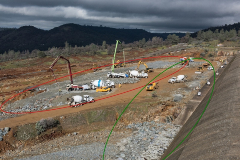
IMHO, patching the red area is not best approach since this will prevent water to egress from the ES waterfall zone.
It would be better to patch and reinforce the green area where is the direct falling water impact.
Also, the new haul road is an obstacle which will retain waters at the ES too close to the main spillway.

 
I think that as a "current event" thread, this thread has run its course. Metabunk is about providing useful information for people, explaining things, and debunking falsehoods.

The thread is too long to fulfil that function, and has now become a conversation focused on minutia and speculation.

I appreciate that many posters here are new to Metabunk, and cannot be expect to know how things work here.

But this current event is over, so this general thread will be closed down tomorrow (Sunday). There are other threads discussing more focussed and current aspects of the situation. Feel free to contribute to those threads, but if you do so please realize that your posts will be held to the Posting Guidelines, which might clash with your natural posting style. Moderation will be much stricter in those threads.
Should a significant change in the situation occur then a new general thread will be opened.

You can also start new threads yourself, providing they strictly conform to the posting guidelines.
 
So what exactly was being debunked here? The thread seems like just a discussion about the minutia, with a fair amount of speculation of a current even. Since pretty much post #1. It's a great discussion. But debunking? Not so much.
 
So what exactly was being debunked here? The thread seems like just a discussion about the minutia, with a fair amount of speculation of a current even. Since pretty much post #1. It's a great discussion. But debunking? Not so much.

See here:
https://www.metabunk.org/current-events-forum-guidelines.t8262/
This forum is intended to allow for the discussion of current events that are likely to prompt conspiracy theories or other false claims or theories that could need investigation and explaining.

Discussion should be fact based, and should be backed up with quotes, links, etc. Avoid speculation and personal opinions.

Major events, particularly those that involve several casualties, are often portrayed in the conspiracy community as some kind of "false flag" fake event that was created by the powers-that-be in collaboration with the media to effect some change (such as prompting war or civil unrest, or justifying restrictions on freedoms locally).

Examples of such events
  • Terrorist attacks
  • Large explosions
  • Natural disasters
  • Plane crashes
  • Unexpected deaths
By allowing open discussion on an event as it unfolds we can observe the roots of the conspiracy theories - which frequently go through several iterations. But observing these early beginnings, and being familiar with the initial stream of information regarding the event, it will hopeful aid in later debunkings of claims behind the versions of the conspiracy theories that pick up steam.

Such events often involve casualties. Please be respectful of the victims and their families. Do not post pictures of injured people or bodies without very good reason, and then preferably via links with warnings.

Individual claims of evidence regarding a theory should still preferably be addressed in individual threads following the posting guidelines.

This forum should only be used in the immediate aftermath of an event, while the story is still developing.
 
The theory of sea floor spreading at mid oceanic ridges was first proposed by Harry Hess in the 1960's (http://www.mantleplumes.org/WebDocuments/Hess1962.pdf). I doubt whether any geologist working in the late sixties would have been able to fully understand the geology at Oroville dam in those terms. However, how they didn't foresee the weakness of rock below the e spillway is strange.

Didn't they acknowledge the weakness when they abandon their plans for the intake tunnels and second power plant? They claimed the rock was unsuitable for tunnels - this would have been roughly under the parking lot and between it and the spillway intake.

And didn't they acknowledge it a second time when they had to cut out ten feet of rotten rock (weathered, breccia or whatever) just to get to something solid to grout to grade for the weir? Not to mention the induced fracturing from the D30s ripping the parking lot/weir areas down to grade. I have to laugh at the thought of them watching that and uttering the phrase 'solid bedrock'. Sorry, but no D30 on earth can rip good, solid bedrock - that's why they need to blast it. The fact that they were ripping it already means some of it was weak.

I would bet dollars to donuts that the geologists DID absolutely recognize the weakness of the rock in front of, underneath and downhill from the e-spillway weir and knew it wouldn't last. Their calculus had to have been on the small probability that the e-spillway would be used at all, or the short amount of time it would be used in the case of the (what they were told) was the extremely unlikely flood. If they had a vote on the matter at the time, I can't imagine that they would have not insisted on armoring the hillside. Either that, or at least constructing a suitable apron a few hundred feet out from the weir.

There's also a mention in one of the documents that the last edit[300' 30'] section of the ogee weir is variable in height and width. The first section closest to the spillway is solid and massive, but the second section further out is obviously tapered to shorter/narrower sections until it ends at the parking lot weir. edit: [Sorry - I'll try to find a reference. California State Water Project Vol. III Storage Facilities Bulletin 200 November 1974 Fig. 79 Pg. 97] If this is the case, then you're not talking about undermining a 40' x 30' piece of concrete, but something much smaller at the far end of the ogee weir. That shorter/narrower profile at the terminal end is exactly where the headward erosion scar would have ended up. Between erosion around the end of (between the ogee and parking lot weir) that smaller profile section and the erosion scar and base scouring, you could have lost the last ogee weir section by it being rotated out of position. At the point of overtopping - +901' - you still have a good 10 or 15' of water behind that section.


transition_section.png

ogee_c_c.png
[edit: Section C-C is sitting on rock cut down 2', so is just under 4' high total and 10' or so wide + the 11' apron - this is what the Sta. 18 erosion scar was eating towards]

That's still a far cry from compromising the entire dam or even the head end of the spillway, but you're still going to have a missing section of weir and an erosion scar 20' or so below the 901' level EVEN if there's no further cutting. Simply losing a section at the end of the weir means you potentially have a quarter-million acre-ft of water that suddenly wants to go out that way in addition to whatever is going out the flood control gates. 200,000 cfm? Still catastrophic to anyone downstream.
 
Last edited:

So then what are the purpose of the threads that were spun off from this one? They ARE the minutiae. What are you supposed to be debunking with the weather forecast for Oroville?

I'm just confused. I've enjoyed and really appreciated this thread and its in-depth discussion. Frankly, I couldn't care less about debunking fake news and clickbait. Anyone with half a brain can filter out that garbage.
 
So what exactly was being debunked here? The thread seems like just a discussion about the minutia, with a fair amount of speculation of a current even. Since pretty much post #1. It's a great discussion. But debunking? Not so much.

Type "Oroville Dam" into google and the amount of "bunk" is amazing. Finding good information is not easy and discussion at the level shown here is as far as I can tell singular to this site. If there are any viable alternatives I'd like to know. That said I do see the point about the volume of posts and it is of course your site to do with what you choose. I read your posting guidelines when I first came here and the focus of all these Oroville threads for the most part don't fit.

So are there other alternatives in some civil engineering or geology forums/sites that are having similar content where interested individuals can go?

And finally, a big thank you to Mick or creating this place. I'll be checking in for other topics in the future after this one is just a memory.
 
Last edited:
So what exactly was being debunked here? The thread seems like just a discussion about the minutia, with a fair amount of speculation of a current even. Since pretty much post #1. It's a great discussion. But debunking? Not so much.

Well, I for one had concerns about the geology that were alleviated. No debunking was needed as I was not overdramatically coming to conclusions without help finding evidence. It was not debunking but it was dispelling a bit of rumor and suspicion for me. I live in Northern California in the eventual watershed of the dams release, and very near the dam in the past. The media reports were not satisfying my level of concern just increasing it. I got help here finding and reviewing evidence that I could understand or others could explained to me, which relieved my major concerns about the ridgeline the spillway is on. Also I learned a lot about the infrastructure that has been filling the glass I drink from my entire life. I am glad for the thread and OK with moving on feeling better about the dam situation. This seems to fall right in line with the 'major incidents thread' clause in the posting rules, and it does seem to have run its course now that the clickbait media has moved on from the dam situation.

I am Hank Hill! Take all the dam pictures you want! Had to get that out, since the thread is closing.
 
I've enjoyed and really appreciated this thread and its in-depth discussion.

Having people enjoy the discussion is not the goal here.

The thread simply no longer maintains a good signal to noise ratio, and so is not accessible to the casual reader. Too much long speculation.
 
I'm not sure what is troubling about it ... that there's a hill son ... you can go up and down 'em ...
... and the emergency weir sits on the top of the hill ... and that would be the down direction ... ;-)
The bedrock is layered, and tilted, so that to follow an individual layer down underground one would have to travel steeply in the NW direction. This is called down dip. The plane that the layer is on will intersect a level surface along a line called the strike. The strike and dip symbol on a map is a long line along strike, and a short line coming from the middle, indicating the down dip direction. Normally there is a number at the end of the short line giving the measured angle from horizontal down to the plane.
geologic map oroville dam dip symbols.jpg

The reason this could be a problem here is if hydrothermal fluids flowed parallel to the layers causing entire layers to be altered in a way that makes them much more susceptible to erosion.
 
Since that pic is from february 10th (at least), i dont think it matters much as that whole area has been bashed with water ever since.

ii.JPG

New poster here. Mainly been reading the contemporary records of the design and construction of the spillways and the dam itself. When the inevitable finger-pointing and blame game about responsibility for this event starts there's probably going be a massive number of allegations to debunk. I'm trying to establish what the position was thought be when this facility was built.

In that connection, I had not seen the above photo before now. It illustrates something I had not picked up, which is that the side walls of the main spillway enclosed the substratum on which the concrete surface was laid (as well as the drainage system referred to in the oft-cited page 133 of the 1974 DWR report on water storage facilities).

Looking back at slightly earlier photos, it seems obvious that at the point where the spillway failed there was a very large void under the concrete surface whereas the report seemed to me to suggest that the concrete had been affixed to the underlying rock. These photos are from shortly after the time the failure occurred and I think must reflect the spillway flow being turned off twice. In each a red arrow indicates a reference point that I think is a seam in the concrete that disturbs the water flow; it illustrates how far back over the apparent void towards the head of the spillway the collapse of the surface extended before continuous running of the spillway was resumed:

2_oroville-dam-damage.jpg
SpillwayThursbh21-2-XL2.jpg
It's hard to imagine a void of that scale being created by an inadequate or damaged drainage system; instead the substratum at this point may have been inadequate from the start. I accept it's hard to believe that this was overlooked in the construction process but it does not appear that the areas shown above had any concrete backfilling (which was called for in the original design).

Someone queried whether there had been core samples taken in the area below the emergency spillway. I've seen no record of that but the 1974 report includes this map showing core samples taken along the route of the main spillway. The key shows that there were both vertical and angled samples although none in the region of the failure. I can't necessarily read anything into that but it's still puzzling:
1_Site_Drawing_Extract.jpg
 
Trust me the main dam isn't even close to your stated criteria.

I highly doubt that the engineers that designed the road bridge constructed over the main spillway even came remotely close to envisioning more than "normal maintenance" heavy equipment passing over it.

More like weekend warriors with some really big boats & trailers occasionally.

I thought I was reading Metabunk, not a whole lot of bunk.
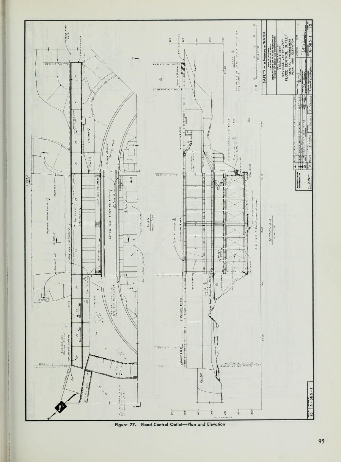
Here is the diagram of the structure from the DWR Facilities report


It shows the bridge is on the same structure as the gates and most importantly the 'Hoist Deck' the services the gates maintanence is next to it and just above it using the same vertical supports. I am not an expert but it looks very solid, hopefully someone with an engineering credential can verify the bridges integrity. I am sorry if my previous answer seemed short and dismissive of your question, I was trying to support it as interesting without answering it.
 
Thank you for getting this thread started Mick West.

I can only conclude that a structural failure occurred here well under maximum designed specifications.

If I lived anywhere below this complex I'd be raising cain when the water recedes.

001.JPG
 
Last edited:
Having people enjoy the discussion is not the goal here.

The thread simply no longer maintains a good signal to noise ratio, and so is not accessible to the casual reader. Too much long speculation.
Does a closed thread become invisible to the public or does it become read only? The thread contains a lot of valuable information in the form of contributions from persons with a varied range of expertise. I have been going back through older posts and reading the linked documents etc. and learning a great deal. It is saddening to lose all of that.

Also, we likely will not know until Monday plus 2 days what the outcome of the present situation may be. Given the accumulated snow-pack, the potential for accelerated melting, and the fact the reservoir is near to capacity three to four months in advance of the normal reservoir peak, I believe the event is not yet over. I haven't wanted to speculate on that because making predictions is difficult, especially predictions about the future.
 
I think that as a "current event" thread, this thread has run its course. Metabunk is about providing useful information for people, explaining things, and debunking falsehoods.

The thread is too long to fulfil that function, and has now become a conversation focused on minutia and speculation.

I appreciate that many posters here are new to Metabunk, and cannot be expect to know how things work here.

But this current event is over, so this general thread will be closed down tomorrow (Sunday). There are other threads discussing more focussed and current aspects of the situation. Feel free to contribute to those threads, but if you do so please realize that your posts will be held to the Posting Guidelines, which might clash with your natural posting style. Moderation will be much stricter in those threads.
Should a significant change in the situation occur then a new general thread will be opened.

You can also start new threads yourself, providing they strictly conform to the posting guidelines.

My 2 cents as someone new here ... this continues to be an evolving discussion ... I want to be able to continue to research and follow the situation - about the emergency weir and the improvements and repairs made and being made regarding it ... this remains a current evolving event that is far from over ...

I feel I and others made a significant effort to research and contribute to this thread ... and to shut it down makes little sense. Simply apply the 'more strict moderation' if necessary to this thread ... but leave it open for those interested in this specific topic .... when interest wanes it will become inactive on its own ...
 
Didn't they acknowledge the weakness when they abandon their plans for the intake tunnels and second power plant? They claimed the rock was unsuitable for tunnels - this would have been roughly under the parking lot and between it and the spillway intake.

And didn't they acknowledge it a second time when they had to cut out ten feet of rotten rock (weathered, breccia or whatever) just to get to something solid to grout to grade for the weir? Not to mention the induced fracturing from the D30s ripping the parking lot/weir areas down to grade. I have to laugh at the thought of them watching that and uttering the phrase 'solid bedrock'. Sorry, but no D30 on earth can rip good, solid bedrock - that's why they need to blast it. The fact that they were ripping it already means some of it was weak.

I would bet dollars to donuts that the geologists DID absolutely recognize the weakness of the rock in front of, underneath and downhill from the e-spillway weir and knew it wouldn't last. Their calculus had to have been on the small probability that the e-spillway would be used at all, or the short amount of time it would be used in the case of the (what they were told) was the extremely unlikely flood. If they had a vote on the matter at the time, I can't imagine that they would have not insisted on armoring the hillside. Either that, or at least constructing a suitable apron a few hundred feet out from the weir.

There's also a mention in one of the documents that the last edit[300' 30'] section of the ogee weir is variable in height and width. The first section closest to the spillway is solid and massive, but the second section further out is obviously tapered to shorter/narrower sections until it ends at the parking lot weir. edit: [Sorry - I'll try to find a reference. California State Water Project Vol. III Storage Facilities Bulletin 200 November 1974 Fig. 79 Pg. 97] If this is the case, then you're not talking about undermining a 40' x 30' piece of concrete, but something much smaller at the far end of the ogee weir. That shorter/narrower profile at the terminal end is exactly where the headward erosion scar would have ended up. Between erosion around the end of (between the ogee and parking lot weir) that smaller profile section and the erosion scar and base scouring, you could have lost the last ogee weir section by it being rotated out of position. At the point of overtopping - +901' - you still have a good 10 or 15' of water behind that section.


transition_section.png

ogee_c_c.png
[edit: Section C-C is sitting on rock cut down 2', so is just under 4' high total and 10' or so wide + the 11' apron - this is what the Sta. 18 erosion scar was eating towards]

That's still a far cry from compromising the entire dam or even the head end of the spillway, but you're still going to have a missing section of weir and an erosion scar 20' or so below the 901' level EVEN if there's no further cutting. Simply losing a section at the end of the weir means you potentially have a quarter-million acre-ft of water that suddenly wants to go out that way in addition to whatever is going out the flood control gates. 200,000 cfm? Still catastrophic to anyone downstream.


Where does the idea the tunnels would have been under the parking lot and spillway ... the uncompleted intakes are to the dam side of the main spillway .... and, according to plans were not intended to go anywhere near the parking lot?

The ripping would, presumably have been to remove the fractured weathered surface material - which they were entirely capable of, to get down TO the bedrock.

You also comment on engineers allegedly realizing the "weakness of the rock in front of, underneath and downhill from the e-spillway weir and kn[owing] it wouldn't last" yet we can clearly see from recent images that the entire concentrated channel the flow from the weir established the length of the hillside - from just below the weir to the river - was clearly blue green bedrock ... which was demonstrated by the minimal erosion of the channel.

You also talk about the tapered parking lot end of the weir ... but fail to note it STILL has a 12' wide 4-6 foot thick toe/apron on the downslope side. You also assert there would be considerable exposed face on the reservoir side at that point, which is not supported by any of the evidence ... the majority of the reservoir side is backed by existing grade which is maybe 8 to 10' below the 901 top elevation, and maintains largely that elevation for 400-500 feet before deeper water ....

My opinion is these various claims that engineers somehow were clueless, or worse simply allowed what they knew to be substandard simply slide, seems nonsensical and unsupported by the facts we do know.
 
Last edited:
The bedrock is layered, and tilted, so that to follow an individual layer down underground one would have to travel steeply in the NW direction. This is called down dip. The plane that the layer is on will intersect a level surface along a line called the strike. The strike and dip symbol on a map is a long line along strike, and a short line coming from the middle, indicating the down dip direction. Normally there is a number at the end of the short line giving the measured angle from horizontal down to the plane.
geologic map oroville dam dip symbols.jpg

The reason this could be a problem here is if hydrothermal fluids flowed parallel to the layers causing entire layers to be altered in a way that makes them much more susceptible to erosion.


And the professionals involved in the years long design, and construction, would be oblivious to this?
 
20170213Ravine999ar.jpg Oroville-dam-2-14-2017-2.jpg 20170213Ravine96.jpg To Scott Gates --

There's a couple good reasons why the weir might not be well attached to the bedrock:

1) The dam operators had reason to believe that the weir would fail within 60 minutes of when they gave their evacuation order. This would indicate that they were observing headwater cutting from surface water or a boil that they considered unstoppable.
"Sunday at 4:42 p.m., when DWR issued this tweet: “EMERGENCY EVACUATION: Auxiliary spillway at Oroville Dam predicted to fail within the next hour. Oroville residents evacuate northward.”
http://www.sacbee.com/news/state/california/water-and-drought/article132361619.html

2) DWR officials were concerned about a boil (water flowing under the weir and coming out of the ground like a spring) coming under the weir.
"DWR officials also hope to reduce the water level by another 50 feet in order to take pressure off the emergency spillway. The level needs to be below the level of emergency spillway in case their is a boil in the weir that is allowing water to leak into the gouge."
http://www.kcra.com/article/evacuation-orders-issued-for-low-levels-of-oroville/8735215

"I understand that is not true," said Ted Thomas, chief spokesperson for the California Department of Water Resources (DWR).
http://www.abc10.com/news/local/verify-are-there-boils-on-the-oroville-emergency-spillway/408761367
20170213_Ravine81.png 20170213Ravine999a.jpg
3) On the evening of the 12th there was one stream running muddy while all the others were running clear. It was the ravine immediately south of the ravine that had cut to near the big weir/parking lot weir interface. See three screenshots from various news videos (photos 2, 3, and 4).
(photos in reverse-order, not sure how to re-sequence them)

4) Obviously, there was no boil, since all erosion stopped when the water stopped coming over the weir. But, that they were worried about a boil indicates that they had limited confidence in the weir footing.

5) The bedrock has vertical weak spots, like this photo shows (pic 1), from immediately below the first section of washed out access road. This weak spot is vertically oriented, and is more than 10' deep. If the engineers in the 1960s cut 10 feet below the surface bedrock to find structural material in this location, they didn't cut deep enough. That slot in the bedrock is at least 15' deep, and appears to have rubble in the bottom.

If this slot was to propagate upstream, it could undercut the weir.

6) If the weir gets undercut, the water coming out the bottom has 60 vertical feet of hydraulic pressure on it. That's much more powerful than the surface water that etched out that weak spot in the first place, and even if the blue bedrock is holding up well to surface runoff and surface pounding, the pressure from 60 vertical feet of water would do more damage than anything that has occurred thus far. Such as etch out laterally at the base of the weir and cause a section of the weir to topple over, thus creating a 30 to 60 foot tall wall of water.

If you figure that the engineers that gave the "60 minutes until uncontrolled release" warning and evacuated 200,000 people had some inside info, then there is a basis for a weak attachment between the weir and the bedrock, and that some observations made late in the day on the 12th would have led them to conclude that weir collapse was very possible. From what I see in the screenshots, it could have been the muddy water emerging from a ravine where all other ravines were issuing clear water, or it could have been the bedrock etching plainly deeper than 10' from the bedrock surface.

I guess I'm saying that I think those engineers in the 1960s were great guys and all, but shortcuts get made sometimes that have negative results down the line.

BTW, why does the northern half of the weir have an apron on it, and the southern half not? Haven't heard anyone discuss this. Seems that the designers were more worried about surface erosion on the northern part of the weir...

Source for ravine images:
20 seconds into this 29 second video
http://www.nbcbayarea.com/news/Patc...roville-Dam-Emergency-Spillway-413830443.html

&

http://www.drroyspencer.com/2017/02...eases-emergency-spillway-repairs-in-progress/
 
Last edited:
The bedrock is layered, and tilted, so that to follow an individual layer down underground one would have to travel steeply in the NW direction. This is called down dip. The plane that the layer is on will intersect a level surface along a line called the strike. The strike and dip symbol on a map is a long line along strike, and a short line coming from the middle, indicating the down dip direction. Normally there is a number at the end of the short line giving the measured angle from horizontal down to the plane.
geologic map oroville dam dip symbols.jpg

The reason this could be a problem here is if hydrothermal fluids flowed parallel to the layers causing entire layers to be altered in a way that makes them much more susceptible to erosion.
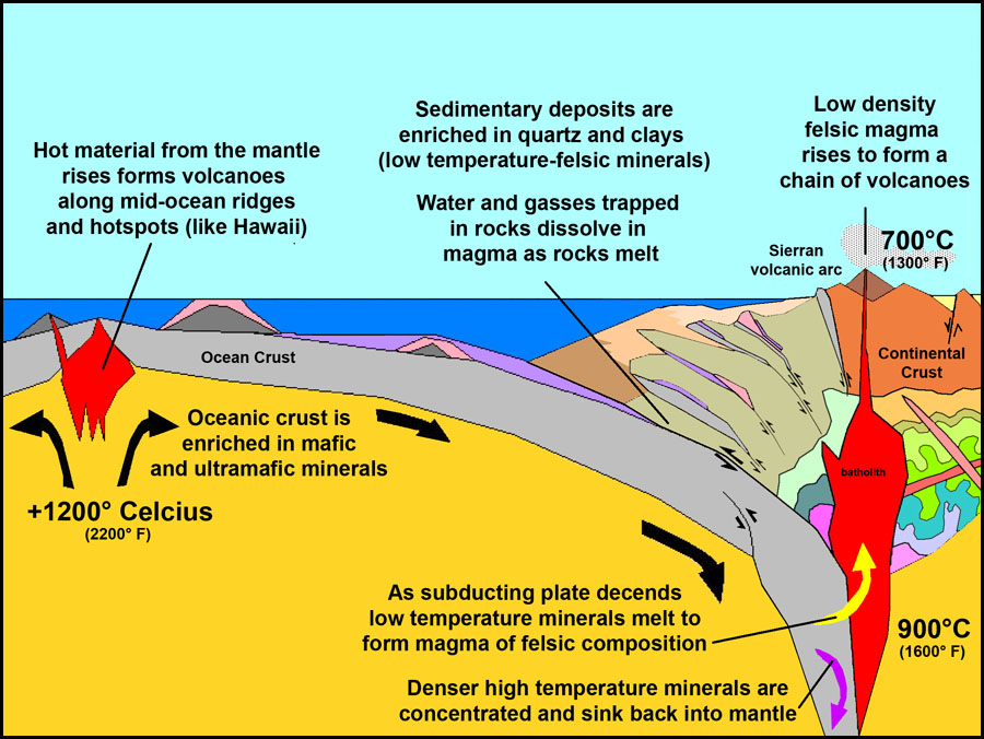
I also am of the opinion, backed by some information I have looked into on mining gold in the sierras, that hydrothermal intrusions LONG AFTER the initial seafloor vents are possible in the dam ridgelines as they are present in the surrounding area. Created by the volcanism that is responsible for the granite in the sierras these hydrothermal fluids came up from below as deep groundwater was heated by subduction volcanism after the first metamorphic events for the geologic unit as it was accreted to the west coast of North America.

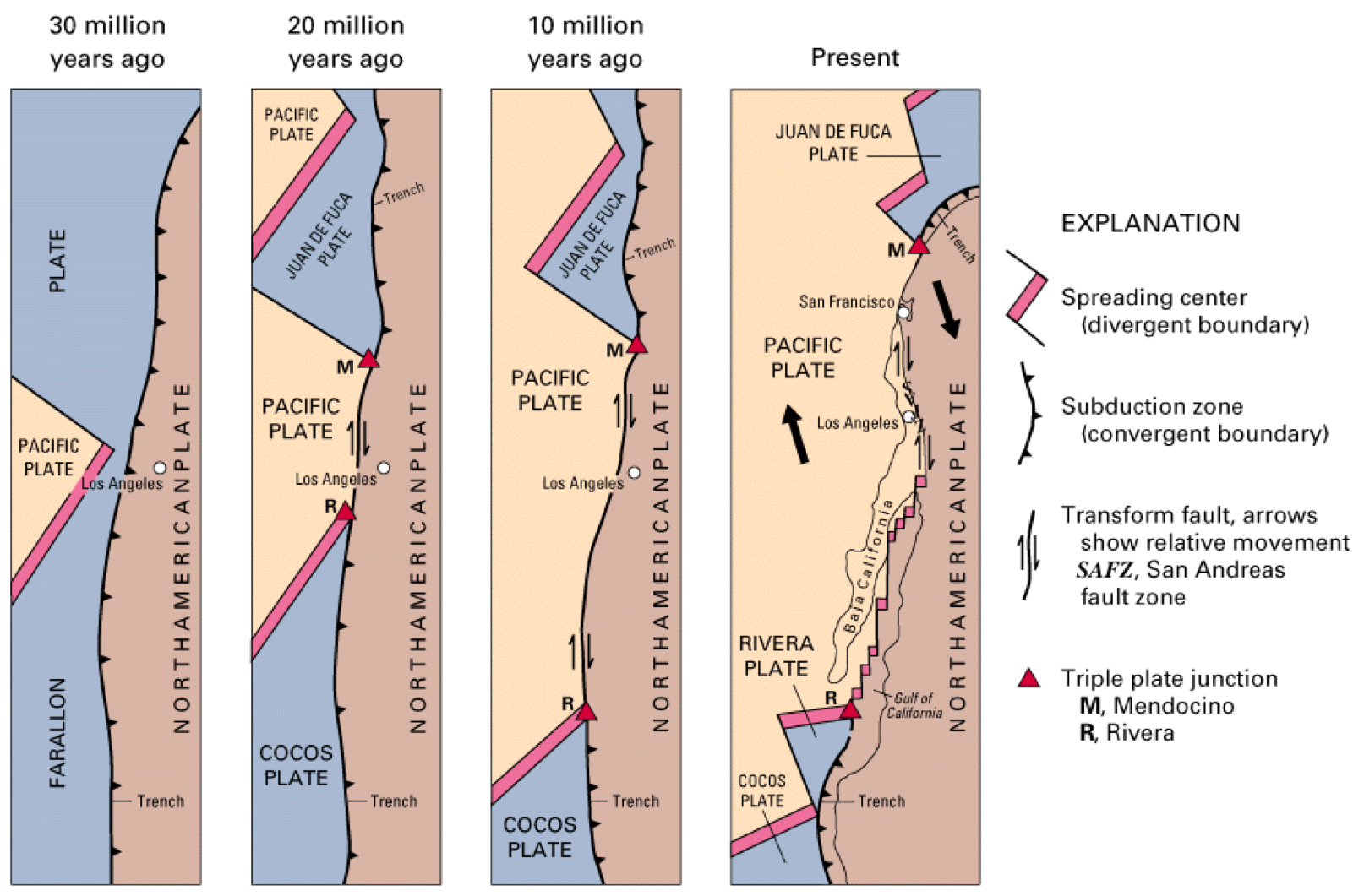
this is how the seafloor basalts that are the local Smartville formation piled up, note they are NOT in the same position now. There has been extension and rotation in the greater continental region in the last 10 million years that continues now and is some of the fastest moving geology outside the Indian subcontinent-Himalayan region.

Image is appropriate for west coast before the seafloor spreading area was overrun by the movement of the North American plate around 40-30 million years ago.

Arrows in the above image show RELATIVE motion to each other not absolute motion to the longitude and latitude.

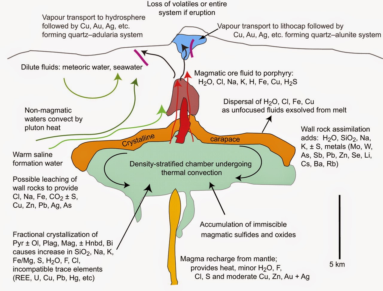
This image shows what happened locally to the Smartville formation as Orogenic gold deposits were formed along intrusive dykes during the formation of the Sierras. What we see is at the level of the brown upper magma chamber in the volcano, that would be Bald Rock right behind lake Oroville.


So the Smartville complex includes hydrothermal features from its creation but also hydrothermal intrusions from the volcanism along side it millions of years later. Bald rock is a granitic pluton, those have lots of thermal features associated, its right on the map behind the lake with some of the pluton under the lake. It heated surrounding groundwater and caused veins of minerals to form in the superheated water, hence the gold in the area.

Here is the longer version from a published source with citations:
The Smartville Block

The Smartville block is the source for most of the gold mines in and near the Sierra Nevada region. This gold-rich block, which lay between the Pacific and North American continental plates, now lies below both the Sierra Nevada and the Central Valley and is about 25 miles wide (Hill, 2006). The block began its voyage inland when it rode over two ocean trenches off the coast of California. It is unknown whether the block began to subduct into the trenches and then sheared off, or just rode over them completely, but in either case the Smartville block continued to move inland and eventually collided with California and helped to form the Sierra Nevada mountain range. With the Smartville complex came the large hydrothermal gold deposits that lay within its crust (Hill, 2006).

Formation of Hydrothermal Gold Deposits within the Smartville Block

Twenty million years later, multiple faults formed throughout the slowly growing mountain range (Hill, 2006). Ground water near the tectonic activity became heated by magma from an igneous intrusion close to the earth’s surface (Hamburger, Hereford, & Simmons, 2010). The high pressure combined with high mineral concentration in the water of minerals such as chlorine, fluorine, and carbon dioxide enabled the water to absorb and dissolve metals, such as gold, in the surrounding rock (Hamburger, Hereford, & Simmons, 2010). This new ore-rich solution, or hydrothermal solution, continued to flow closer to the earth’s surface by entering other thin fractures, or joints, in the overlying rock (Hamburger, Hereford, & Simmons, 2010). As the water cooled the ore precipitated into a solid form again and formed veins of ore within the thin fractures, which are also known as hydrothermal deposits (Hamburger, Hereford, & Simmons, 2010). Ore minerals are generally found precipitated with quartz, calcite, and other minerals (Hamburger, Hereford, & Simmons, 2010). It is these other precipitates that have helped people locate potential source rocks for gold during and after the gold rush of the late 1840‘s.
Content from External Source
 
Last edited:
My opinion is these various claims that engineers somehow were clueless, or worse simply allowed what they knew to be substandard simply slide, seems nonsensical and unsupported by the facts we do know.
there are no claims to that effect that I am aware of, there are questions as to the level of understanding they had given the best information they had at the time. you need to allow for the possibility they made calls that science and engineering have since deemed to be not the best solution, this is a fact in nearly every aspect of science and engineering and it is very likely to hold true in this case as well. This dam is a prototype for how to hold this much water back in this geology, I for one think the original designers and engineers deserve a parade in their honor, but I also think the decisions they made deserve full review and public scrutiny. And if found to be an issue and if the dam needs to be completely ripped down they still deserve the parade because California and the United States made BILLIONS in profit from agriculture in the central valley during this dams operation. you dont have to kiss ass to support brilliant people, you actually have to back them up by giving as good an effort as they did at thinking things through and moving stuff if needed.
 
View attachment 25043 20170213Ravine96.jpg To Scott Gates --

There's a couple good reasons why the weir might not be well attached to the bedrock:

1) The dam operators had reason to believe that the weir would fail within 60 minutes of when they gave their evacuation order. This would indicate that they were observing headwater cutting from surface water or a boil that they considered unstoppable.
"Sunday at 4:42 p.m., when DWR issued this tweet: “EMERGENCY EVACUATION: Auxiliary spillway at Oroville Dam predicted to fail within the next hour. Oroville residents evacuate northward.”
http://www.sacbee.com/news/state/california/water-and-drought/article132361619.html

2) DWR officials were concerned about a boil (water flowing under the weir and coming out of the ground like a spring) coming under the weir.
"DWR officials also hope to reduce the water level by another 50 feet in order to take pressure off the emergency spillway. The level needs to be below the level of emergency spillway in case their is a boil in the weir that is allowing water to leak into the gouge."
http://www.kcra.com/article/evacuation-orders-issued-for-low-levels-of-oroville/8735215

"I understand that is not true," said Ted Thomas, chief spokesperson for the California Department of Water Resources (DWR).
http://www.abc10.com/news/local/verify-are-there-boils-on-the-oroville-emergency-spillway/408761367

3) On the evening of the 12th there was one20170213_Ravine81.png 20170213Ravine999a.jpg stream running muddy while all the others were running clear. It was the ravine immediately south of the ravine that had cut to near the big weir/parking lot weir interface. See three screenshots from various news videos (photos 2, 3, and 4).
(photos in reverse-order, not sure hot to re-sequence them)

4) Obviously, there was no boil, since all erosion stopped when the water stopped coming over the weir. But, that they were worried about a boil indicates that they had limited confidence in the weir footing.

5) The bedrock has vertical weak spots, like this photo shows (pic 1), from immediately below the first section of washed out access road. This weak spot is vertically oriented, and is more than 10' deep. If the engineers in the 1960s cut 10 feet below the surface bedrock to find structural material in this location, they didn't cut deep enough. That slot in the bedrock is at least 15' deep, and appears to have rubble in the bottom.

If this slot was to propagate upstream, it could undercut the weir.

6) If the weir gets undercut, the water coming out the bottom has 60 vertical feet of hydraulic pressure on it. That's much more powerful than the surface water that etched out that weak spot in the first place, and even if the blue bedrock is holding up well to surface runoff and surface pounding, the pressure from 60 vertical feet of water would do more damage than anything that has occurred thus far. Such as etch out laterally at the base of the weir and cause a section of the weir to topple over, thus creating a 30 to 60 foot tall wall of water.

If you figure that the engineers that gave the "60 minutes until uncontrolled release" warning and evacuated 200,000 people had some inside info, then there is a basis for a weak attachment between the weir and the bedrock, and that some observations made late in the day on the 12th would have led them to conclude that weir collapse was very possible. From what I see in the screenshots, it could have been the muddy water emerging from a ravine where all other ravines were issuing clear water, or it could have been the bedrock etching plainly deeper than 10' from the bedrock surface.

I guess I'm saying that I think those engineers in the 1960s were great guys and all, but shortcuts get made sometimes that have negative results down the line.

BTW, why does the northern half of the weir have an apron on it, and the southern half not? Haven't heard anyone discuss this. Seems that the designers were more worried about surface erosion on the northern part of the weir...

1.) There was no boil. When first notices the erosions was moving fairly rapidly, back cutting toward the weir. That said numerous media reports identified the authorities quickly noting, just after the evac order was given, thet the back cutting had slowed significantly or stopped - which is totally consistent with scour of weak weathered surface materials.

The "60 minutes" claim was based on original observed scour progression, which as noted quickly slowed or stopped once the weak surface material was gone.

2.) ... about the claim there being boils on the dam's emergency spillway... from your link:

"I understand that is not true," said Ted Thomas, chief spokesperson for the California Department of Water Resources (DWR). A boil would have to leak through bedrock in order to occur.

"I don't think it should be possible," said Jay Lund, Director at the Center for Watershed Sciences at UC Davis."

"If a boil did somehow occur on the spillway, crews would have to build a dike around the spillway or lower the water on the lake. However, this would only be a temporary solution.

A more permanent fix would be to build a grout curtain, which is a barrier which protects or strengthens the foundation of a dam from seepage.
Content from External Source
A review of plans shows there already was a grout curtain.

3.) A review of the numerous photos before, during and after shows the bench had several areas of simple dirt soils, mostly in surface areas. Initial scour would cause these ares to run muddy as the surface fines were washed free. These SAME areas are shown running clean after the initial scour. And "after" photos show the erosion did not ultimately advance firther towards the base of the weir nor was there any evidence of interaction with the base of the weir, let alone a boil drawing soil from below or behind the weir.

4.) That there was no boil reflects nothing on their confidence level. It simply reflects there observations at the time - observations that occurred in the context of the belief there was a serious risk of failure, which they quickly realized was overstated.

5.) The land - both current and originally - slopes DOWN from the weir. The cut you note is well down slope from the weir and in the general vicinity of or the access road - which was built using standard compacted rock fill, which in the face of a widespread 12,000 cfs flow was expected to be sacrificial. A spot of weathered rock down slope a distance and elevation from the weir, which well could represent close to the then existing weathered surface rock when construction of the weir was completed, is not indicative of the foundation bedrock below the weir.

And the fact the engineers specifically noted overcutting and backfilling with concrete to insure good bedrock should be considered a clear representation that good bedrock underlies the weir. This idea they didn't know what they were doing, or somehow shirked their responsibility, because of a cut a significant distance from the weir base is not supported by any fact.

Last there is zero evidence, even if this back cut progressd to the weir - that it would in any way be able to back cut thru the bedrock base of the weir.

6.) There is NO POINT on the weir where there is "60 vertical feet of hydraulic pressure on it" ... first the back cut would have to cut thru competent bedrock to have any chance of any hydraulic pressure. Next it would have to cut upward thru many feet of material on the reservoir side of the weir to come in any contact with any water.

At the main spillway end the base of the weir is at least 11' underground, which puts bedrock foundation at appx 836. On the reservoir side existing grade is appx 875 - meaning just the top 26 feet are exposed in any hydraulic water pressure ... 39 feet is BELOW GRADE. In order to compromise anything a back cut would have to cut 11' feet down to the weir base, and then cut thru appx 64 feet of competent bedrock foundation including a grout curtain and heavy rubber membrane, just to get to back of the weir.

It would then have to backcut more than 39' to the surface of existing grade to reach the water.

At the parking lot end a backcut would have to cut up to the weir, again at least 10+ feet deep, back cut thru the bedrock and then cut first upward to within about 10 feet of the top of the weir to reach water column and then 400-500 feet into the reservoir to reach deeper water. And the depth of the base of the weir is nowhere near 60'.

And then, even IF a backcut pulled off this near miraculous task ... it would have to dramatically widen the cut in the bedrock foundation - far enough that the heavy concrete weir collapsed or toppled. Which is completely unsupported by the facts.

We know how the blue green bedrock performs under significant scour pressure. We can see it firsthand observing the concentrated spillway down the hillside - where all that water did nominal if any cutting to the bedrock at all.

The officials who made these decisions - the Sheriff actually - made them in the heat of battle - working in uncharted territory, where the risk of being wrong was enormous. They acted, under extreme pressure, on a very limited set of data and facts, that the cut appeared to be advancing rapidly toward the weir ... and IF it made it there, and IF it somehow cut thru the bedrock foundation, and IF is cut thru the many feet up to the surface grade, and if it then cut through 400-500 feet horizontally to reach deeper water, it might spill thru a 30' breach.

A position which the data showed them very quickly was highly unlikely, when the seemingly rapid backcut toward the spillway all but stopped - nearly as fast is it started.

One more time - the orig topos show existing grade was appx 900 at main spillway end of the weir. And was appx 880 through the rest of the length of the 900' weir. A the location of the 'deep' cut you are focused on - down slope from the weir, the existing grade was appx 825 elevation ... not remotely surprising rock between as much as 75' below the orig grade of the spillway location would be near the surface and weathered.

As to the southern part of the weir, the construction plans posted here multiple times, clearly show a 12' apron on the weir ... and that it was located at 840 elevation ... at least 5 feet below current finished grade at that spot.

20170215_50overlay.jpg
 
I also am of the opinion, backed by some information I have looked into on mining gold in the sierras, that hydrothermal intrusions LONG AFTER the initial seafloor vents are possible in the dam ridgelines as they are present in the surrounding area. Created by the volcanism that is responsible for the granite in the sierras these hydrothermal fluids came up from below as deep groundwater was heated by subduction volcanism after the first metamorphic events for the geologic unit as it was accreted to the west coast of North America.

this is how the seafloor basalts that are the local Smartville formation piled up, note they are NOT in the same position now. There has been extension and rotation in the greater continental region in the last 10 million years that continues now and is some of the fastest moving geology outside the Indian subcontinent-Himalayan region.[/EX]

Theoretical assertion is always trumped by onsite actual data. And the onsite data shows the seams of non-competent are narrow and run vertically in the area. They would be clearly apparent to any competent engineer of the time. And the record indeed shows they were well aware of and addressed these substandard areas throughout the project.

The record (and physical evidence) shows they were well informed, and did address areas of substandard rack when they found them.

Numerous photos - both current and historical - show competent blue-green bedrock prominent and dominant throughout the area. Plans show soil tests were performed throughout the area - both vertical and slant - and up to several hundred feet deep.

Again - the record shows engineers were knowledgeable and professional, and insured competent bedrock was identified and present for foundations throughout the project, and substandard areas were overcut to competent bedrock and back filled with concrete as necessary.
 
there are no claims to that effect that I am aware of, there are questions as to the level of understanding they had given the best information they had at the time. you need to allow for the possibility they made calls that science and engineering have since deemed to be not the best solution, this is a fact in nearly every aspect of science and engineering and it is very likely to hold true in this case as well. This dam is a prototype for how to hold this much water back in this geology, I for one think the original designers and engineers deserve a parade in their honor, but I also think the decisions they made deserve full review and public scrutiny. And if found to be an issue and if the dam needs to be completely ripped down they still deserve the parade because California and the United States made BILLIONS in profit from agriculture in the central valley during this dams operation. you dont have to kiss ass to support brilliant people, you actually have to back them up by giving as good an effort as they did at thinking things through and moving stuff if needed.

If there was credible evidence to support these claims I would agree. But there is not. All of the evidence available - plans, construction information, and current physical evidence all support they were knowledgeable, compete and accurate.

A cut in an eroded area of weathered rock nearly 300 feet down slope from the weir and appx 80' lower elevation is not evidence of anything useful about the bedrock supporting the weir.

And I refuse to ignore the clear evidence the engineers were well aware of, and concerned about, insuring competent bedrock in foundation areas. You do not go to the considerable effort and expense to do cleanouts and 10' of concrete backfill on what you know is substandard bedrock.

Agaun - if there was a shred of evidence the bedrock beneath the weir was in any way compromised I would be the first to address it. But there is not. All the data and information points to the exact opposite.

Just becasue one thinks it is theoretically possible, and or "fits" what the perceived notion may be, does not make it accurate or true.
 
Last edited:


IMHO, patching the red area is not best approach since this will prevent water to egress from the ES waterfall zone.
It would be better to patch and reinforce the green area where is the direct falling water impact.
Also, the new haul road is an obstacle which will retain waters at the ES too close to the main spillway.

The green area experienced minimal erosion. And much of it was already hardened in the past - for example the grouted rock at the bottom of green area.

The rest of the green area has already been armored and crushed gravel base put down on top of it as a cap and driving surface for truck traffic ...

And a close up view shows that the grey areas are all concrete - which is partially covered by the haul road base rock on the driving/work surface of the bench...
 
Theoretical assertion is always trumped by onsite actual data. And the onsite data shows the seams of non-competent are narrow and run vertically in the area. They would be clearly apparent to any competent engineer of the time. And the record indeed shows they were well aware of and addressed these substandard areas throughout the project.

From the 1974 Storage Facilities report, page 67:

Regional Geology and Seismicity
Oroville Dam lies in the foothills on the western
slope of the Sierra Nevada, a westerly tilted fault
block
with a core of granitic rock. A series of tightly
folded, steeply dipping, metamorphic rocks overlies
the granite core along its western and northwestern
flanks.
Content from External Source
as well the area of non competent rock under the spillway was not vertical or narrow.

To help clear this up about this claim of narrow vertical and shallow seams in the rock, can you please provide quotes from the source, links to the PDF and page numbers, when you make reference to information? That is what I am doing to provide citation, seems to be the normal procedure here.
 
My 2 cents as someone new here ... this continues to be an evolving discussion ... I want to be able to continue to research and follow the situation - about the emergency weir and the improvements and repairs made and being made regarding it ... this remains a current evolving event that is far from over ...


My town is putting in a community vegtable garden, that will require excavating and erosion issues. Should we start a thread about that project too?

:) Dont mean to sound overly sarcastic, but the fixing of infrastructure at a single dam in California (while generally interesting) is not the type of topic Metabunk covers.

Mick has provided other threads to cover this 'current event'

he is being overly generous. Seriously, how many times can a handful of amateurs post their opinion about what 'may be' under the soil in the Oroville Dam area. And argue about whether dirt and soil washing away because a river of water washed over it ,is a sign of the apocalypse or something.

There has been some great info provided in this thread. ...Not all the speculation about rock..., but the plans to the dam facilities and erosion plans, topographical maps etc. But the general public won't be able to find them in the midst of all this chit chat.

You few gents can continue your converstation in Private Message (you can invite multiple people to participate in a PM) or find a "California Chit Chat" forum.
 
Status
Not open for further replies.
Back
Top