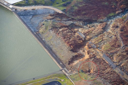
A deep erosion channel cut by 15k cfs, that headcut its way toward the emergency spillway, is circled in red.
View attachment 24976
A photo taken from within this hole shows the rock.
View attachment 24974
As opposed to the competent gray sheeted dikes composed of diabase, this rock appears to show breccia, which can be formed in a fault. However, in this setting situated at a mid-oceanic ridge, there is another process that forms breccia. Mid oceanic volcanoes at spreading centers erupt magma, whose flows can form rocks known as pillow lavas. The rapid cooling by seawater causes rapid cooling on the exterior surface, called chill margins, can produce glass, with chunks often breaking off that tumble down and form piles. Here is a video of this process, note the chunks falling off.
Further troubling the situation is the dip of the layers is towards the emergency spillway and main spillway gates. So even if the spillways are on competent bedrock, there are possibly incompetent layers extending under them.
View attachment 24989
Layers of altered material extend deep under ground (outside blue lines). This hillside is at the north end of the parking lot, 1968.
View attachment 25005
In regards to Steven Ward's simulation, with the parameters of his fail being 600m x 25m, I see it as a possibility, however slim. Imagine the main spillway fails to the extent that it is shut off, and a train of AR's arrive after the one currently over the horizon. Without steel reinforcement, bolted to the bedrock, and under slab drains, the current concreting, under sustained flows over a 100k cfs for extended periods, will be like putting a band-aid on a gangrene leg. Imagine the average flow of Niagara falls at 85k cfs going over, things would deteriorate rapidly.
Headward erosion could migrate from the yellow zone, into the green zone, unleashing the blue arrow. As flows continue, the ogee weir gets undermined, goes over the falls, taking the main spillway gates with it. Unlikely, but possible.
View attachment 24995
Considering the incompetence of the bedrock below the emergency spillway, both spillways should be sunk much deeper into the ridge.
Your position however disregards the documentation that shows the builder went to extra effort and expense to identify competent bedrock below the spillway, and overcut and backfill with concrete any imperfect areas.
Your position also presumes that the engineers and builders at the time did not understand the composition of rock in the area, which I think is pretty preposterous. The properties you note are not new discoveries. More, or perhaps most, importantly these experts spent decades excavating and working int these areas.
You also discount that most, if not all, your yellow area, and indeed most of the bench, and slope to the access road, has been filled with competent rock and grouted - in some places as much as 25 or more feet deep. Also that a less robust version of this rock and grouting was done at the base of the weir at the main spillway end - where the weir is nearly 60 feet tall ... and performed without erosion.
At minimum this armoring has moved any erosion downslope to the access road and beyond.
You note, but don't acknowledge, that almost all the erosion is in the weathered surface area rock. In fact the erosion on the flat bench below the ogee weir at the parking lot end that authorities were so worried about ... that was rapidly backcutting toward the weir, was reported to have stopped its rapid advance and erosion shortly after the evac decision was made. Indicative that it was the weak weathered surface layer rock, and once it was eroded and more competent subgrade rock was encounter the back cut slowed and/or stopped. Keep in mind this rock has been exposed to the elements for 50 years
You also I believe fail to consider the base of the ogee weir is well below existing surface grade. There is at least a 12' wide apron or "toe" on the downslope side of the weir, that is shown as 6' thick. Then there is the bedrock foundation which is reported grouted and concreted as necessary. The backcut would have to be substantially deep to cut under the bedrock and weir itself.
I think you discount the clear presence of blue-green bedrock exposed during the event. The entire channel from the access road down to the river is shown to be blue green bedrock, and despite that nearly the entire flow from the emergency weir consolidated and flowed down this channel, there was minimal erosion and seemingly none in its base.
We also have photo evidence of exposed blue green bedrock at appx the 850 elevation to to the emergency weir side of the main spillway at the top - immediate adjacent to the emergency spillway.
We know the main spillway end of the emergency weir's base next to the main spillway (and the 850 elev exposed bedrock next to it) is at least 11' below existing grade there. This means the bedrock foundation begins at appx 836 elevation. We also know existing grade on the reservoir side is appx 875 - meaning the base is nearly 40' below grade on that side.
From my limited knowledge of the area and information in these threads, including from you, this is an upthrust area and these seams are vertical in nature. We can see this by numerous photo examples including from you. As such, as i understand it, it would be unlikely to find a seam below existing bedrock.
We know there were no seams like this in the bedrock foundation of the ogee weir - as the builders noted they removed any marginal rock and back filled with cement. Again - I fully trust these engineers and the like were fully competent having worked with and on this site from the 1950's and then thru the years of massive excavation and construction - including tunneling - throughout the area, and well understood exactly what they were working with.
Test borings were done, including in the spillway area down several hundred feet as well. Add that to the clearly identified areas where competent bedrock is exposed and I believe there is high confidence in the locations of bedrock in the area.
Again these were highly experienced and competent engineers and builders. To me - a suggestion they did not fully fully and completely understand the subsurface conditions - does not seem credible.
I DO have concerns with the parking lot extension of the emergency spillway. It is embedded just 4' in the ground. And absent the access road it is a shard drop from the bench below it - which was eroding as it sloped to the road.
That said your "green area" assertion fails I believe to consider that the grade on the reservoir side of that end of the ogee weir is within appx 6 feet of the top of the ogee weir - at 901 elevation. AND that it is appx 500 feet of flat ground at mostly that higher elevation, before reaching deeper water. The shallow depths over that 500+/- feet would see a moderate flow even in the chance a backcut migrated that 500 feet to deeper water ...
Your scenario that a backcut around the end of the ogee weir would topple it is simply not in my opinion credible.
Again - there is existing grade nearly to the top of the wall on the reservoir side there. And we know there is competent bedrock below it. Any backcut would migrate away from the end of the ogee weir due to all these "hardening" factors.
Last ... the same construction reports that informed us of the extent of extra effort and expense builder incurred in insuring competent bedrock below the ogee weir, also tells us a few more important relevant facts:
"Emergency Spillway. The grout curtain was continued under the left reach of the emergency weir near the upstream face, and formed drains are used under the downstream half. The crest of the emergency weir to the right, which is only 1 foot above the excavated channel, is keyed 2 feet into the foundation. Both weir sections were checked for overturning and shear friction safety factor and found to be satisfactory.
In part of the emergency spillway, an additional 10 feet of excavation was required to reach acceptable foundation rock, resulting in considerable additional time for excavation and placement of the backfill concrete to subgrade.
Approximately 90% of the chute foundation required blasting to reach grade"
My opinion... YMMV
Areas we know good bedrock is identified:

")