Oroville Dam Spillway Failure

Status
Not open for further replies.
Here's the NWS Quantitative Precipitation Forecast through midnight Thursday with an overlay of the Lake Oroville watershed:


The precipitation scale is at the top. The overlay comes from a map with a slightly different projection but it's mostly within one or two forecast cells of the correct path. In a few hours I'll post the same but for snowfall so the liquid precip/snow amounts will be distinguishable.
 
An interesting photo from the dam construction:
20170214-143318-h8gqr.jpg


This April 29, 1963, photograph shows a crew washing and cleaning the dam site’s core block area, which had to be cleaned down to the bedrock prior to any concrete pouring. The amount of concrete poured into the core block was 231,000 cubic yards. The core block acted as a toe for the embankment that would be placed during the 1964 season. (Courtesy of CDWR.)

Matthews, Larry R. (2014-01-20). Building of the Oroville Dam, The (Images of America) (Kindle Locations 290-293). Arcadia Publishing. Kindle Edition.
Content from External Source
Relevant for two reasons. Firstly it's likely something similar was done with the emergency spillway weir - giving it a stronger connection with the rock below.

Secondly it kind of illustrates the problem DWR has now. They can't just pour concrete over dirt. Ideally they would be pouring concrete over bedrock - but they don't really have the time so they are putting rocks over dirt and then concrete over and around the rocks.

The areas with the most erosion will probably end up being the strongest, as they will have the most rocks and concrete closest to the bedrock
 
20170214-143949-ikgb0.jpg

When Reagan arrived for the inauguration of the dam in 1968 they landed the helicopters on the intake areas of the man spillway. The rocks behind him are part of the ridge that separates the main spillway from the e-spillway and should prevent any procession of damage in the event of the e-spillway failing.

Basically this whole area is a rock ridge through which the main spillway is cut, making it very stable at the top.

20170214-144500-g4cbm.jpg


20170214-145008-tvbut.jpg

This video is poor quality, but shows the spillway up close

Source: https://www.youtube.com/watch?v=XZO_744b_Gs
 
Last edited:
Looks like sun glint to me. You can see it picking up the ripples.
It kind of looks like sun glint, but it would be really weird to get a steady reflection in two spots on a level surface like that (to illustrate, try seeing two images of the sun in the same flat mirror). If two images were present due to ripples, they not only would not be constant in location, there would be many more.

Remember the photos of this place which were taken when the water was lower? Much of the area on the back side of that lip was at an elevation only slightly below the top of the concrete lip. My guess is that there are two white objects on the ground, in very shallow water, clearly seen from such a high angle. I really don't believe air bubbles would look like that, for if enough air was rising to see so clearly at such range (remember the scale of things - that concrete lip is enormous), you'd see turbulent action as well. I'm thinking of the countless aerators I've seen, where if you can see the bubbles at all, you can also see the way there is constant outward flow in all directions from the spot at which they contact the surface. Nothing like that going on here.
 
What might this pipe be?
20170213-230508-395dr.jpg
Well, it's not a light pole, because the square "base" is not centered. Also, I've never seen a steel light pole that wasn't tapered. It's not a "service entrance" because the "curved" part was once just as straight as the rest, but it was crimped and bent (it's also far too enormous to have been mounted to the side of a job shack as was suggested by another poster). I've mentioned that my work involves foundation soils (for buildings and roads/parking lots, for the most part), and when digging on former construction sites or fill areas you commonly encounter all manner of discarded items. My guess is this pipe had some temporary function during construction, or that it was part of a permanent utility installation that was damaged. Every large-scale earthwork site ends up with damaged underground utilities due to inattentive truck drivers and lost flagging. It happens all the time, and where do the broken pieces go? They get buried wherever fill happens to be being placed at that time.
 
Last edited:
20170214-150205-3bwfu.jpg

Bottom of the spillway (source). I would not be entirely surprised if they did something like the lip here, as a temporary fix, after stopping the main spillway. Just something to prevent more erosion. i.e. build a lip above the "Waterfall".
 
On the http://rdcfeeds.redding.com/lakelevels/oro.cfm page there is a column for outflow, and a column for riv_rel which is about 18,000 cfs higher. Does riv rel mean 'river release' ? and why is it 18k higher than the outflow? I thought it might be that they have activated (i.e. wrecked) the power dam release system, but its likely something else.

What I mean is - the present value of the ~1 GW turbines might pale in comparison to the value of getting another 15k cps out constantly over the spring/summer/fall so they can work on the normal spillway.
 
Last edited:
Drone video from yesterday morning, shows the erosion from a variety of different angles.

Source: https://www.youtube.com/watch?v=VBP-4ah3U6s

This video clearly shows chemical weathering of the bedrock nonuniformly. The main channels have eroded down to fresh bedrock (gray). Orange rock is chemically weathered bedrock and will be removed by decent water flows. Mostly we see highly weathered bedrock (bright red) that even minor flowing water will strip away in no time. Bedding of the bedrock is steeply dipping, large holes excavated into the fresh bedrock (pools of water still in them) by the mere 12k cfs were layers or zones in the bedding that had undergone chemical weathering.
 
Zone of chemically weathered bedrock following steeply dipping bedding. Much bedrock had already been stripped from above during construction. The steep bedding will have likely aided in zones of weathered bedrock extending quite deep below both spillway structures.
north end e spillway ogee weir anotated.jpg
 
Some interesting comments sent via email:

...
It seems from this bit of history that the main spillway channel was excavated by ripping and not by blasting, indicating that - despite the story of the rock of the embankment being so hard that it wore down the points and shanks of the rips - the spillway bedrock really isn’t all that hard and competent ...

The key point here being that "ripping" (essentially excavating with large-toothed buckets or large clawed attachments) implies softer rock. I'm not entirely sure this is correct, as even the quote above notes the rock was so hard it wore out the ripping claws.
All your conclusions here are correct. We deal with this fairly commonly. A ripper can loosen rock that is much harder and more durable than that which can be excavated with a backhoe, and often a really large backhoe will use a ripping tooth to tear up rock, then switch to using the bucket to scoop out the pieces (here, they call it a "frost tooth" because it's used to cut frozen ground more often than to excavate in rock), but really durable rock cannot be ripped. Period. Drilling and blasting is the way to go in that case.

I had looked at the cut for the upper part of the main spillway, and also its upstream approach, in other photos, and at first thought that it might have been drilled and blasted (a good sign regarding durability), but in better photos you can see the strongly sloped sidewalls, and that's something that suggests an excavation process of the sort you have described here (I'm still catching up on recent posts). My guess would be that the rock in that area is mostly "durable enough" to resist erosion during storm events, but as became clear the other day, zones of much softer material are present below the lip of the emergency spillway.
 
It kind of looks like sun glint, but it would be really weird to get a steady reflection in two spots on a level surface like that (to illustrate, try seeing two images of the sun in the same flat mirror). If two images were present due to ripples, they not only would not be constant in location, there would be many more.

Remember the photos of this place which were taken when the water was lower? Much of the area on the back side of that lip was at an elevation only slightly below the top of the concrete lip. My guess is that there are two white objects on the ground, in very shallow water, clearly seen from such a high angle. I really don't believe air bubbles would look like that, for if enough air was rising to see so clearly at such range (remember the scale of things - that concrete lip is enormous), you'd see turbulent action as well. I'm thinking of the countless aerators I've seen, where if you can see the bubbles at all, you can also see the way there is constant outward flow in all directions from the spot at which they contact the surface. Nothing like that going on here.

See post #456 on page 12.
I think those white things are the crests pf breakng waves.

I note also that the profile of the (ogee) weir, forming the lip of the emergency spillway, (see photo in post #484 top of this page) is not the same as that shown in the various drawing documents a few pages back. So those were just schematic sketches for for the dimensions and not accurate drawings depicting detail of the shape of the structure, even though the weir is referred to in those papers as an "ogee" which has a parabolic down-flow face, after a slight rise on the up-flow side.
 
On the http://rdcfeeds.redding.com/lakelevels/oro.cfm page there is a column for outflow, and a column for riv_rel which is about 18,000 cfs higher. Does riv rel mean 'river release' ? and why is it 18k higher than the outflow? I thought it might be that they have activated (i.e. wrecked) the power dam release system, but its likely something else.

That's the river release from the pool at the bottom of the dam, it includes other streams flowing into the pool, and can also vary with the gated weir at the end of the pool
 
I'll be honest... this is like ants with matchbox cars moving grains of sand around.. I hope they don't need to use the E spillway again cuz all that rock and concrete aint nothin if that gets overtopped again IMO.. I call this optics ... looks like they are doing something. in reality .. its not buying much safety. my two cents. you put an obstacle in waters way and it does what? goes around it..
this is the week ahead https://www.wunderground.com/cgi-bin/findweather/getForecast?query=Oroville,+CA

and this guy working on the damn says "stay the hell out of oroville" says 5 inches expected in Chico therefore 1.5-2x as much at dam location... for what its worth.
Source: https://www.youtube.com/watch?v=oWL56N9J23Y
 
Last edited:
An interesting photo from the dam construction:
20170214-143318-h8gqr.jpg


This April 29, 1963, photograph shows a crew washing and cleaning the dam site’s core block area, which had to be cleaned down to the bedrock prior to any concrete pouring. The amount of concrete poured into the core block was 231,000 cubic yards. The core block acted as a toe for the embankment that would be placed during the 1964 season. (Courtesy of CDWR.)
Content from External Source

I and a few others made educated guesses regarding the placement of the weir the other day. If the weir was constructed as shown on the plans, there would have been no place for that "key" or ridge on the bottom if this method of cleaning the bedrock had been used, unless that initial undercut (that's what we call any excavation deeper than the planned depth of bearing) would have been backfilled with concrete to establish a flat bearing surface. However, jut a simple graded strip would have allowed for that, and given the obvious lack of concern about emergency-spillway erosion that old documents (posted here) have illustrated, I tend to doubt that they went to great lengths to anchor the weir in the illustrated manner, especially since the lateral pressure exerted on the weir would not be all that great in the first place (lateral pressure at the base of the dam would be enormous, leading to a much greater need for solid connection to the underlying rock). You are correct though, that this process of cleaning the rock would have greatly reduced the likelihood for erosion to work its way headward beneath the weir, but since the whole reason for cleaning the rock was entirely different at the dam location (and again, given the overall attitude back then about emergency-spillway serviceablity), I'm not confident this was done there.
Content from External Source
 
Weathered bedrock following bedding circled in green. There is fresh talus that has fallen onto the gravel located behind the concrete wall that appears to have originated from one of these zones of weathered bedrock. I don't mean to promote fear, and i doubt that piping or boils or water will flow through these zones and undermine the dam or anything of that nature. Simply showing the nonuniform competency of the bedrock, that when water is flowing directly upon it, erosion will be able to progress. These zones of weakened bedrock are present underneath the
concrete base of the spillway in this picture.
main spillway gates anotated.jpg
 
So I was watching the 3 helo's today focused on filling this area inside the corner of the curve by the parking lot and wondering why they were focused on it ... seems a minor spot - but they are throwing a lot of resources at it ...


Then I saw a panned out view and it became more apparent ... look at what is on the other side of that road. There is a big reason why the guardrail is there.

If the erosion breaches the road there its a sharp drop into a swale/ravine ... if there is 2 or 3 feet of water on the parking lot and it gets released it could be enough to headcut back thru the parking lot and to deeper water ... just be a question if the cut ran outta water or reached deeper water first ...

 
Is anyone sure that the stuff below the sp
So I was watching the 3 helo's today focused on filling this area inside the corner of the curve by the parking lot and wondering why they were focused on it ... seems a minor spot - but they are throwing a lot of resources at it ...
.
Indeed - why not just dump 300 truckloads of mixed rock and gravel on the edge of the parking lot, making a 4' high wall and force all the water in a less than 100,000cfs emergency spillover over the main part of the emergency spillover area. They should have a road into there tomorrow
 
Last edited by a moderator:

I and a few others made educated guesses regarding the placement of the weir the other day. If the weir was constructed as shown on the plans, there would have been no place for that "key" or ridge on the bottom if this method of cleaning the bedrock had been used, unless that initial undercut (that's what we call any excavation deeper than the planned depth of bearing) would have been backfilled with concrete to establish a flat bearing surface. However, jut a simple graded strip would have allowed for that, and given the obvious lack of concern about emergency-spillway erosion that old documents (posted here) have illustrated, I tend to doubt that they went to great lengths to anchor the weir in the illustrated manner, especially since the lateral pressure exerted on the weir would not be all that great in the first place (lateral pressure at the base of the dam would be enormous, leading to a much greater need for solid connection to the underlying rock). You are correct though, that this process of cleaning the rock would have greatly reduced the likelihood for erosion to work its way headward beneath the weir, but since the whole reason for cleaning the rock was entirely different at the dam location (and again, given the overall attitude back then about emergency-spillway serviceablity), I'm not confident this was done there.
Content from External Source

And the shear size and weight of the weir ... which is misleading to many from photos ... by all appearances the weir is appx 60 feet tall (plus the foot) ... it is 60 feet at the base - including the appx 12' wide by 6' thick "toe"

When I did an estimate it was appx 118,000 tons (look earlier in thread). The uniformity and seems on exterior seems to show it was unlikely to have been poured on site.

A good, flat, uniform base/footings would have had to have been prepared or it would have added stressed to the concrete potentially causing cracks etc ...
 
So I was watching the 3 helo's today focused on filling this area inside the corner of the curve by the parking lot and wondering why they were focused on it ... seems a minor spot - but they are throwing a lot of resources at it ...


Then I saw a panned out view and it became more apparent ... look at what is on the other side of that road. There is a big reason why the guardrail is there.

If the erosion breaches the road there its a sharp drop into a swale/ravine ... if there is 2 or 3 feet of water on the parking lot and it gets released it could be enough to headcut back thru the parking lot and to deeper water ... just be a question if the cut ran outta water or reached deeper water first ...

It is possible that the emergency spillway ogee weir was built to simply protect the main spillway gates, and that the parking lot aspect of the emergency spillway is designed to act as a sacrificial plug along the lines of the 1986 Auburn coffer dam failure. This would "safely" lower the upper few meters of lake oroville in the case of a thousand year event with inflows to the lake of up to 500k cfs, without loosing the main dam or most of the water held within.
 
20170214-150205-3bwfu.jpg

Bottom of the spillway (source). I would not be entirely surprised if they did something like the lip here, as a temporary fix, after stopping the main spillway. Just something to prevent more erosion. i.e. build a lip above the "Waterfall".
Okay, I'm just on a posting flurry tonight, but this is interesting. This time, it has nothing to do with what's in the post I'm "replying" to, but rather, something I see in that photo. Notice the strong outflow from those under-slab drains at the bottom of the spillway. In normal construction, the importance of employing drainage fills which which act as a filter is a practically-unknown concept among most engineers. I would hope it's better known among dam designers, but this was 50 years ago, so who knows. Anyway, a good filtering material is very well graded, with particles of many different sizes, and in proportions that allow the different sizes to lock together with a minimum of void space between them. A good filtering fill will have the interlocking particles fit so closely that even silt-sized soil particles can't move through the material, or even enter it more than a fraction of an inch or so. However, such materials are a bit pricey, and also, when placing fill on a steep slope, fill materials that are poorly graded are often preferred to simplify grading and compaction operations.

In this case, if they used a poorly-graded material such as clear stone, and water flow beneath the slab was such as we see here, fine soil particles would end up being washed from their original location below the fill layer via water flowing through the void spaces in the fill layer. Eventually this will lead to undermining of the fill layer, and loss of support for the overlying slab, and I have to wonder if that could be what happened to the slab of the spillway.

This principle of using filter soils is so poorly known that all building codes in my state and at least some others (and I suspect most others) specifically call for the use of clear stone (such as pea-gravel or crushed rock for which the finer particles have been removed by sieving and/or washing) for use as drainage fill. The reason for this? The code is written by plumbers, not soils engineers. This is why I'd hope the situation would be different for a dam, but again, who knows. Numerous structures have been severely damaged as a result of undermining because the builders used clear stone as required by code, but overall, fortunately, it's actually a rare event (failure of the drainage system due to plugging is more common). In any case, on a steep slope such as this, for the material between the slab and the subgrade to be able to block all movement of soil particles while not preventing the flow of water would be critical. I wonder if anyone can work their searching magic and find the original job specs for the final-grading layer that was to be placed below that slab.

Just thinking out loud, here.

Just to clarify, since someone is sure to point out how often foundation undercuts are backfilled with clear stone, I'll emphasis that the problem arises where there is significant flow of water through that clear stone. If there's water there but it's just sitting still or barely moving, there will be no problem.
 
Last edited:
You can always get more haul trucks ... additionally they have 18 wheeler dump trucks hauling to a stock pile the other side of the main spillway. There are at least 2 major areas needing repair on top of the bench in front of the weir ... each should have a dozer ... another dozer should be working with the small material being placed next to the base of the weir and the cement pumpers ...

Another dozer and backhoe could/should be working along the washed out road segment.

There should be 2 to 3 addtl cement pumpers ... one for each of the two repair areas and one or two working with the trucks laying smaller material along base of the weir to get it cemented. And potentially another working with the group filling along the damaged roadway ...

Once they got the damaged areas on the bench filled they should start doing a rock overlay, reinforced with cement, over the top of the entire top bench ... they also should be filling the smaller erosion from the lip of the bench down to the damaged road and grouting that with cement as well.

The farther away from the base of the weir the better. And if you get that done do a second lift of more cement reinforced rock if time permits ...

I would also repair the base at least for the road section - create at least another bench the width of the road ... use larger boulders and cement to fill the damage and then smaller material and cement grouting on top of that.

With 3 or 4 dozers, a couple backhoes, 3 or 4 cement pumpers and enough haul capacity that entire bench could have been repaired and topped with cement today alone, and the "bench for the road could have been repaired and hardened with cement as well.

I've done this type work for years - including in much harder rock than this ...
 
This area is an at risk/high risk section that needs to be addressed IMO.

The parking lot spillway is a minimal, narrow, concrete wall. I suspect it isn't very deep at all.

Water that flowed over it near its connection to the weir, turned and made its laterally to, and down, the face of the exposed rock here - starting a cut below the red circle.

Worse - the connection between the weir and the slightly taller and narrow parking lot wall, created a 'jet' effect that ejected diagonally at about a 20-30 degree angle which was the major cause (along with the side slope lateral erosion shown) for the head cut damage we saw in the end of the bench below the weir..

Additionally you can see seepage in the weir apron at the connection to the parking lot wall.

While I suspect the weir goes down as much as 40 feet below the apron shown here ... I also suspect the parking lot wall is much shallower. It also has little mass.

This connection it would seem - between weir and the parking lot wall ... especially considering the concentrated flow that was demonstrated at this point (and the damage it caused) - is a weak point highly susceptible to a failure.

There is soil behind it for 300 to 500 feet before deeper water, but if a breach occurred here - if there was a 1.5 foot head over top of weir as with the last time - it seems once a head cut progressed to deeper water there could be enough flow to continue to erode that cut once started...

 
Last edited:
I kind of agree. I don't know why they are not throwing the kitchen sink at the foot of the aux-spillway while they can. Even for media optics sake.

The weather is good for now and access to the site with heavy equipment is obviously doable. I would have expected to see an organized bee hive of heavy equipment activity below the weir today.

The video from today that SFX posted at post #451 seems like kind of a lame response to the situation.

Some chin whisker scratching types, some shovel leaners and a whole lot of not happening urgency.

Displacing 180,000 people per second on a WE're, ahh not really sure what the heck is going on "up" at the dam is just as unorganized as what appears to be going on directly below the weir.

That's a whole lot of family lives hugely disrupted.
 
Last edited:
Saw this earlier ... have not verified ... if accurate appx half the rain as last event over a similar time frame ...

#OrovilleSpillway #Erosion here's the facts. 8 days of rain (15") lake rose 50'. Current discharge gives the lake about 30' of room once inflows exceed outflows. There are 8 days of rain at 7.5" in forecast for the river basin. It will be very close!
Content from External Source


Source: https://twitter.com/jimt52869/status/831569141442109441
 
See post #456 on page 12.
I think those white things are the crests pf breakng waves.
This may be too minor of an issue to worry about, but I did look again, and there are no breaking waves. There are more than enough solid objects in view on which the action of larger waves could be seen, if such action were present. Also, what waves are present can be seen, and they are smooth and non-disturbed, and further, though it may be an artifact of an extremely low number of frames per second in the video (not likely that this is the case, though), I'd say the waves are moving away from the weir, so there would be far too little fetch in the first place. There are other problems with the breaking-wave idea which are best discussed in the context of experience on bodies of water, so I won't go there now.

On my second viewing (several times, this time around), one spot appears to be an object breaking the surface, and there seems to be a bit of a trail of disturbance formed as each wave passes, probably providing an angle of incidence that reflects the sun. I can't tell about the other, but it appears more likely to be just a reflection, but it may also be the result of surface disturbance.

Anyway, it's not important, but it's kind of fun to try to interpret.
 
Any new pics of the Main Spillway from today?

Want to add-Thank you everyone for all of your input and time, especially Mick. It's very hard to navigate what is really going on and this site makes it a little easier, thank you.

Another add: Take out the fact this is a potential natural disaster and I can't help but be fascinated by all of the engineering talk and problem solving:)

Grew up in Gridley and have spent a lot of time on Oroville.
 
While I suspect the weir goes down as much as 40 feet below the apron shown here ... I also suspect the parking lot wall is much shallower. It also has little mass.


I've posted on this before, but the very close proximity of natural, undisturbed rock on the downstream side of the weir, and the resulting wavy elevation of the deflection strip (showing that that native rock is present below that strip too), suggest that there was no deep excavation here. A deep excavation wouldn't have been impossible, but to end up with the native rock so close, it would have been bank-formed, and that would have been an incredibly difficult method compared to making the hole oversized to some degree. And going down 40 feet would be far beyond any design I've seen. For a deep excavation, I can't imagine a reason for doing it the hardest possible way. I can imagine the structure being placed on the existing grade, especially since that's actually the only method I've seen used on dam structures that size (and we already have the documentation to show that they were skimping on costs for this part, and on that subject, I had similar thoughts about that little wall at the edge of the parking lot. Oh, and that's further logic against the weir being in a deep excavation. Why do extreme over-design on one part and extreme under-design for another?).
 
Last edited:
20170214-143949-ikgb0.jpg
Again, thank you Mick for the fantastically clear imagery.
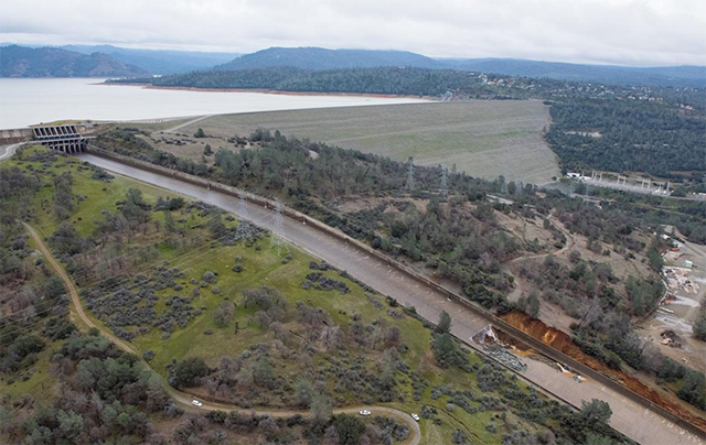
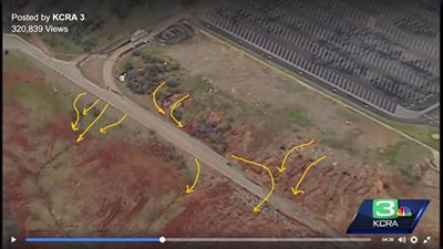
A possible area of interest, were there to be large flows over the spillway again might be the area in your second image, next image below the Reagan image of post # 496 .
From the intersection of the roadway and the right apex of the red ellipse proceed counterclockwise along the ellipse to the main concrete spillway. This currently is higher topography (unkown, but likely based on appearance, topos or different perspectives would clarify this point) perhaps soil, perhaps buried rock similar to the "bedrock" in (post #438) ----[ just east of the main spillway at the very top which had the stepped cuts and the softer eroded parts which dumped tiny debris atop the "gray gravel" immediately adjacent to the east bank of the concrete spillway outlined by the red lines in the image of post # 438 ][ awkward....The red lines in post#438 .]
Given that the tiny bit of debris overlays the "gray gravel" (for lack of a more descriptive term) , that indicates the erosion happened subsequent to dam construction , ( i.e. less than ~ 50 years ago). This gives some sense of the competency of those "debris bands" in the "hard bedrock". This does have an effect on erosion by water flow. High water flows often undermine the banks of channels , as they do this the channel bank migrates. In this case , eastward migration of the channel bank along the trace of the red ellipse might be worth monitoring.
Again, not having the photo and computer skills to accomplish this, it might be a worthwhile endeavor to have a daily photograph correlated with flows which tracked any cutbank migration.
This would only occur in the case of the auxiliary being used.

When Reagan arrived for the inauguration of the dam in 1968 they landed the helicopters on the intake areas of the man spillway. The rocks behind him are part of the ridge that separates the main spillway from the e-spillway and should prevent any procession of damage in the event of the e-spillway failing.

Basically this whole area is a rock ridge through which the main spillway is cut, making it very stable at the top.

20170214-144500-g4cbm.jpg


20170214-145008-tvbut.jpg

This video is poor quality, but shows the spillway up close

Source: https://www.youtube.com/watch?v=XZO_744b_Gs
 
little frustrated trying to get new images.... from what i can tell here as of yesterday morning they seem to have lost nearly 1/3 of their remaining spillway...
the break was/is? at the last bushes before the power line towers.. thats a huge distance from the original "pothole" easily 1/4 if not 1/3 of reamining spillway. so where's the new photo's . i had a feeling theyd be hard to come by. Mick posted some this am but Im skeptical . would love to see more on breakpoint migration...

 
#OrovilleSpillway #Erosion here's the facts. 8 days of rain (15") lake rose 50'. Current discharge gives the lake about 30' of room once inflows exceed outflows. There are 8 days of rain at 7.5" in forecast for the river basin. It will be very close!

Other facts: They're now releasing continuously at 100,000 cfs. If they keep doing that during those next 8 days, the result will be different than the much smaller releases during the previous rainfall. (Looks like they're not publishing the future releases for ORO...)

 
little frustrated trying to get new images.... from what i can tell here as of yesterday morning they seem to have lost nearly 1/3 of their remaining spillway...
the break was/is? at the last bushes before the power line towers.. thats a huge distance from the original "pothole" easily 1/4 if not 1/3 of reamining spillway. so where's the new photo's . i had a feeling theyd be hard to come by. Mick posted some this am but Im skeptical . would love to see more on breakpoint migration...

There was a post this morning about this, there was not any significant upward erosion of the main spillway between 11 Feb and the morning of 14 Feb:
Closeup on the latest DWR photo taken 8:55 this morning.

View attachment 24613

Appears pretty consistent with this image from Feb 11, so that's good.
20170214-132216-m7jwj.jpg

Aaron Z
 
There was a post this morning about this, there was not any significant upward erosion of the main spillway between 11 Feb and the morning of 14 Feb:


Aaron Z
of course the first pic is titled feb14 2016 so who knows when that was taken ... i sorta doubt it went 100yards and just stopped... is all im saying . would love to see some live pics from today.
 
Ever since I first saw a close up picture of the emergency spillway, I have been trying to understand what was going on there. Even before the water started going over it, there was nothing there to absorb the force of the water and stop erosion of material up close to the weir. After following this site for a couple of days, I MAY have an answer thanks to all the things that have been posted here.

When they were building the dam they knew they needed a weir to act as the emergency spillway, they knew that the top of it needed to be at 901, and they knew they needed it to the left (looking upstream) of the main spillway. They needed to put it on competent (solid) rock, and they needed a shelf of competent rock out in front of it, say 100 feet wide to stop the upstream erosion. You can see this in the drawing on reply #354. Those little hash marks at the bottom of the cross-section of the weir are a standard symbol for rock.

So they started removing the soil and loose rock to the left of the main spillway until they had a bench 150 feet wide. They removed the rock with rippers (post #428) because with a ripper you can create a level surface, and you know when all the loose or weathered rock has been removed. As they moved further away from the main spillway the competent rock was higher, so the rock bench kept moving up. This is why the weir gets shorter as it moves to the left.

The reason the competent rock gets higher is because there was more soil over the rock, as can be seen in post #450. The Rock Whisperer in post #409 explains that the rock in the area breaks down due to its exposure to rain an air, so the competent rock is generally at some constant depth under the surface of the soil. As the hill get higher, the solid rock is located at a higher elevation.

As Mr. Neubauer states in post #374 the designed weir on solid rock will not go anywhere.

The light bulb really went on for me when I saw the second picture in Post #484. You can see what looks like a solid rock wall that is perfectly flat on top of it. It appears to be a solid block of rock. On top of this big slab of rock is a very small wall, the top of which is a 901 feet. This wall is also shown in the cross-sections on Post #354. So in this area they found competent rock at an elevation slightly lower than 901 an needed this very low wall to keep the top of the emergency spillway consistant. Past this area (the parking lot) the hill goes on up (as can be seen in the backgound of the second picture in Post #484) so they didn't need to extend the emergency spillway any further.

So at the end of construction they had an emergency spillway extending from the main spillway all the way to the hillside, AND there was a shelf of strong competent (solid) rock extending out in front of it for 100 feet (or so.)

The problem is that as the Rock Whisperer pointed out, this rock can weather greatly when exposed to the elements. So over the next 60 years the rock broke down and when the emergency spillway was used for the first time a couple of days ago, the "solid" rock started to erode. It was "solid" 60 years ago when they built the dam and everybody thought it was still good up until a couple of days ago. I sure they were quite surprised when their "solid" rock started to wash away.

I would expect that the work they are doing now is just a patch. When the danger of flooding is over I would expect that they will build a substantial structure in front of the entire length of the emergency spillway to make up for the missing "solid" rock.
 
of course the first pic is titled feb14 2016 so who knows when that was taken ... i sorta doubt it went 100yards and just stopped... is all im saying . would love to see some live pics from today.
Look again, the first picture is listed as being from today ("Closeup on the latest DWR photo taken 8:55 this morning", the 2nd picture is listed as being from the 11th ("Appears pretty consistent with this image from Feb 11, so that's good.")...

Aaron Z
 
Croyle mentioned Cranes that were setting up at the base of the Dam to load barges into the river to dredge sediment, any updates on that? Any photos at all? Probably not, it's hard to get photos these days, no one has a camera on them....
 
of course the first pic is titled feb14 2016 so who knows when that was taken ... i sorta doubt it went 100yards and just stopped... is all im saying . would love to see some live pics from today.

The MAIN Spillway erosion has tracked all the way to the dirt path just below Power Lines, in 4 days ... 5 ?
They will have to start dumping into the AUX, to save the MAIN ...
And it is going to dump rain Thurs., Friday, & Monday ! Maybe 10 inches ... more than 5 !

Do the math ... Oroville watershed is 3,600 square miles ...

This IS the MOST epic train wreck I have ever watched !
 
Last edited:
I feel like it's almost impossible to not get continuous periscope feeds or random images/videos of events like this. Does no one in the area really care to post that stuff, as all that's on Youtube is mainly fake looped 'live' streams. Do they have this area pretty sealed shut to the public currently?
 
Last edited:
Last edited by a moderator:
Status
Not open for further replies.
Back
Top