
You are using an out of date browser. It may not display this or other websites correctly.
You should upgrade or use an alternative browser.
You should upgrade or use an alternative browser.
Oroville Dam Spillway Failure
- Thread starter Mick West
- Start date
-
- Tags
- oroville dam
- Status
- Not open for further replies.
MortarBoarder
Member
Looks like an old light pole ;-)
Square base - curved top ...
Looks to me like an old "service entrance". The curved part sticks up from a building and the power line for the building comes into it. The square bottom is fastened to the side of the building and electrical conduit brings the wires inside. I suspect it was on the side of a construction shack on this side of the dam, and was disposed of by burying it in the surrounding gravel in the landscaping surrounding the road to the parking lot.
That road below the emergency spillway is obviously sacrificial. It only takes a few days with gravel trucks and asphalt to rebuild the road, and the recreational boaters will find someplace else in the meantime.
Peaked at 902 ft regarding elevation. Currently at 889. To reach 852ft, 50ft lower than the peak, the lake will need to drop another 37ft. With the current flow of the main spillway stable at 100,000cfs, will they be able to reach this goal before the rains begin to increase inflows? Of course, it must be considered that each subsequent drop in elevation contains less water volume respectively. Additionally, the current inflows are fluctuating. However, these variables appear to have had negligible impact so far, as seen in the local media's graph, which strongly suggests they will not reach the goal ahead of stronger inflows in time without considerably larger releases from the main spillway. Unless, the increase of inflow volume from precipitation will be delayed enough for the goal to be met.


Sounds about right.I'm not an engineer or a hydrologist so I didn't appreciate what 100k CFS meant and what the dam engineers are dealing with. So I looked at Mississippi flow https://waterdata.usgs.gov/mo/nwis/current/?type=flow At Saint Louis the median flow of the Mississippi is 121,000 cfs. Holy cr&p that's a LOT of H2O, unless I have missed something. I kept checking to see if I had an order of magnitude error but I don't think so. Did I miss something?
The flow over Niagara Falls is maintained at 100,000 CFS (except at night when they switch the falls off
") ).
).deirdre
Closed Account
I'm saying 1" of rain isnt going to wipe out the weir. (maybe, hence 'the math'). And they should take their time if that is the case.Correct me if I am wrong here, but if by a dry spillway you mean just rainfall and not another overflow over the lip, then continuing this work should be OK. Assuming that they will fill the area with rocks and boulders and pour concrete over it in order to mitigate erosion effects, then this should be fine for the weeks to come.
PhyllisO
New Member
Thanks for bringing up hydraulic mining, which was another form of man-made stripping down to bedrock. I'm looking forward to reading the report. Thanks for posting.There hasn't been this much hydraulic excitement here since the heyday of hydraulic mining. "Hydraulic mining in the Sierra Nevada" covers the environmental impacts of that mining as well as other human activities such as logging and grazing, on the draininges including the Feather and Yuba, all the way to the Sacramento delta and San Francisco Bay navigation. This extensive report was commissioned by Congress to the USGS when petitioned by the miners, who had been enjoined from mining, partly because of damage to farmlands and other lands downstream of the mining. Marysville was particularly hard hit by floods which strew gravel all over their lands. https://pubs.usgs.gov/pp/0105/report.pdf
Thank you Rock Whisperer.
That's what we needed.
An additional tool that might help widespread understanding of this event, might be a dated sequence of photographs from the same location, or close to the same location, that record the time and date of the image, the amount of CFS prior to the image, and perhaps a scale.(i.e. distance to dam, vertical scale too)
The first location I'd be interested in seeing would be the concrete spillway. Perhaps the best way to do this would be to organize by CFS and duration of that flow. Obviously a simplistic, but telling, overview. I apologize for not having the access to the imagery, the time, and the skills to this and I apologize for advocating someone else do the work, however , the power of such a presentation and this compelling situation overrides my few social graces.
This approach might also helpfully illuminate other areas of concern.
Thank you metabunk for providing this forum, or as George Orwell might say, double-thank you.
Last edited by a moderator:
Peaked at 902 ft regarding elevation. Currently at 889. To reach 852ft, 50ft lower than the peak, the lake will need to drop another 37ft. With the current flow of the main spillway stable at 100,000cfs, will they be able to reach this goal before the rains begin to increase inflows?
Probably not with a straight line extrapolation, but they will keep drawing down as the inflows increase, so the level will keep falling until inflow reaches 100K cfs. Heavy rain will arrive Wednesday night, with moderate rain for a week. Expected to be less than last time.
A solid 100K outflow is far more total water than the storms bring. Have a look at the last two months on inflow
The volume of water coming is in the area under the blue line - so pretty much just the two peaks in Jan and Feb.
If they had been running 100K out the whole time, the volume of water outflowed would be the area of the red rectangle, which is several times more than the inflow.
So I think they will be fine, if they can keep up 100K.
Another look at that, focussing on just the last 10 days. You can see we are making some very solid room compared to the amount above 100K in the last storm.

(I should have started that lower rectangle a bit to the right, as it only counts when not overflowing. Close enough).
Again, if they can keep up 100K there will not be a problem from the rain overtopping the emergency spillway again.
(I should have started that lower rectangle a bit to the right, as it only counts when not overflowing. Close enough).
Again, if they can keep up 100K there will not be a problem from the rain overtopping the emergency spillway again.
There is so much spam on youtube now I can't find reliable current video or images of the spillway. And even news articles are using old images. Does anyone know of a reliable source that is releasing current images or video?
Probably not with a straight line extrapolation, but they will keep drawing down as the inflows increase, so the level will keep falling until inflow reaches 100K cfs. Heavy rain will arrive Wednesday night, with moderate rain for a week. Expected to be less than last time.
A solid 100K outflow is far more total water than the storms bring. Have a look at the last two months on inflow
View attachment 24589
The volume of water coming is in the area under the blue line - so pretty much just the two peaks in Jan and Feb.
If they had been running 100K out the whole time, the volume of water outflowed would be the area of the red rectangle, which is several times more than the inflow.
So I think they will be fine, if they can keep up 100K.
Thanks for supplying this data! You're quite knowledgable. Do you think the main spillway could become more problematic, such as the failure area creeping upward?
Do you think the main spillway could become more problematic, such as the failure area creeping upward?
That's the most significant risk right now. It looked solid yesterday, so I await pics of the "waterfall" area from today with great interest.
for anecdotal perspective, the CFS i experienced on a three week Grand Canyon trip was 6,000 -12,000 which is in the very lowest range, and not anywhere near the high range...still...it felt like a boatload world of water and I keep that experience in mind here thinking about having that or some high multiple of that coming across that frsh hill face....at minimum, the debris field at the discharge point will increase.I'm not an engineer or a hydrologist so I didn't appreciate what 100k CFS meant and what the dam engineers are dealing with. So I looked at Mississippi flow https://waterdata.usgs.gov/mo/nwis/current/?type=flow At Saint Louis the median flow of the Mississippi is 121,000 cfs. Holy cr&p that's a LOT of H2O, unless I have missed something. I kept checking to see if I had an order of magnitude error but I don't think so. Did I miss something?
Here's a couple of quotes and a number from today's(Tuesday Feb14,2017 morning edition) LA Times...."Officials say they want to lower the lake level 50' by Wednesday to avoid another overflow on the ...emergency spillway.....peak (aux-spillway) flows were 12,600cfs compared with the designed capacity of 450,000cfs, according to the DWR."
The webcam behind the dam is showing constant helicopter activity dropping bags, also zooms in on the emergency spillway from time to time.
https://www.parks.ca.gov/?page_id=29411
This is from 9:18AM today (Feb 14)

https://www.parks.ca.gov/?page_id=29411
This is from 9:18AM today (Feb 14)
Some interesting comments sent via email:
Here's a Quad D9 with ripping attachments. They basically just pull it though the ground. Height seems adjustable for harder terrain.

I suspect they used ripping even with relative hard rock because they needed a lot of precision. However it does suggest some limits on the toughness.
The key point here being that "ripping" (essentially excavating with large-toothed buckets or large clawed attachments) implies softer rock. I'm not entirely sure this is correct, as even the quote above notes the rock was so hard it wore out the ripping claws.External Quote:
I've been following your discussion of the Oroville situation (https://www.metabunk.org/oroville-dam-spillway-failure.t8381/page-9). In thinking about the structural properties of the "bed rocks" into which the spillway is built, I found http://www.petersoncat.com/history/oroville-dam to be of interest:
"The scope and difficulty of the project really put Peterson to the test in terms of whether to supply the traditional means or really step up and be progressive and offer new solutions to head-scratching problems. According to Western Construction magazine's October 1966 issue, "Buster's Quad D9s were the star of the show on the $20 million spillway. Excavation of some 4 million cubic yards of solid rock made it one of the biggest ripping jobs in the West at the time. One million yards of that material had to be ripped using various methods, including Peterson's new Quad D9 arrangement, outfitted with two 10-ft shanks, each with 4-ft extensions. The rock was so hard that when points and shanks wore out, they simply replaced rather than rebuilt them. Also new on the dam portion of the project was CAT's new hydraulic 660 tractors pulling Buster's 97-ton Athey rock wagons [patent # 3185528] designed especially with hydraulic actuating hopper doors for Oroville".
It seems from this bit of history that the main spillway channel was excavated by ripping and not by blasting, indicating that - despite the story of the rock of the embankment being so hard that it wore down the points and shanks of the rips - the spillway bedrock really isn't all that hard and competent; see pg. 6-7 of http://www.dot.ca.gov/hq/esc/geotec...rences/31_Handbook_of_Ripping_Caterpiller.pdf (extract summary attached). That the native rock could be excavated by ripping may perhaps might suggest that it can also be rather easily eroded by stream flow, which might account for the deep, narrow channels cut during the emergency spillway flow (attached picture from your site). Notice I said "may perhaps might suggest" since I really don't know. My local expert on rock excavation geophysics is busy retiring this week, but I intend to pester for an answer as I can.
I'm keeping an eye on the waterfall at the end of the upstream intact portion of the main spillway. Judging by pictures from 4 to 6 days ago, it seems that damage first appeared at a location where the concrete transitioned from resting on ripped bedrock to resting on base fill above earth materials. After rapidly removing the dirt, base and concrete, the waterfall seems now to be working its way upstream through the bedrock, with portions of previously supported concrete panels perhaps now hanging over the edge. Hard to see or measure when enveloped in mist and spray (attached picture), but the rate at which the waterfall works its way upstream – if any - is something to keep track of.
Here's a Quad D9 with ripping attachments. They basically just pull it though the ground. Height seems adjustable for harder terrain.
I suspect they used ripping even with relative hard rock because they needed a lot of precision. However it does suggest some limits on the toughness.
MortarBoarder
Member
The key point here being that "ripping" (essentially excavating with large-toothed buckets or large clawed attachments) implies softer rock. I'm not entirely sure this is correct, as even the quote above notes the rock was so hard it wore out the ripping claws.
Picture on first page of thread shows the intake to the normal overflow area shortly after construction. The sides look as if they were shaped by many parallel drill cuts, not scraping. The plans also show intent to trim the sides of the spillway chute the entire way down the slope, although I haven't seen mention of the method used.
Oh, that same picture shows trees/bushes in the reservoir area near the overflow intake. That implies that specific areas were carved as desired, and there wasn't heavy equipment casually sculpting the whole area.
Edit: found the image.
Edit: Hmm. Interesting. Look on our right side of the spillway. Gravel on the new concrete. That rock has broken down enough that there were too many bits of rock to remove it all during construction.
Last edited:
Over. The parking lot is essentially part of the spillway (by design) and was underwater.View attachment 24595
I am curious, the helicopters started working on a hole yesterday at the entrance to the parking lot, WAY to the left of the spillway. Where did that water/hole come from. Water over the parking lot, or under?? thoughts?
Edit: Hmm. Interesting. Look on our right side of the spillway. Gravel on the new concrete. That rock has broken down enough that there were too many bits of rock to remove it all during construction.
Gravel? I think you are looking at the fill behind the concrete side walls?
Loose rock up there isn't really an issue. It's what lies beneath.
SR1419
Senior Member.
Expected to be less than last time.
Less precipitation AND colder storms with lower snow levels and thus less immediate runoff which is good news.
Pat Dilling
New Member
From a newby to this blog, thank you all very much for the great information. Although some of the technical posting is beyond me, you folks have been a great source of info. I live in Olivehurst, currently evacuated, and have been checking here often. I have been a "user" of Lake Oroville for many years and spent a few years in the IT division at DWR so I have some laymen's knowledge. Trying to forecast how fast they will be able to drop the lake based on elevation is more challenging because the lake is wider as the was rises so the same amount of water released will have different results at different elevation. Perhaps an easier prediction is the time it will take to reduce to a particular volume of water. Watching how many acre feet to get to the TOC might be easier to do.
Gravel? I think you are looking at the fill behind the concrete side walls?
The 'gravel' looks like an easy to erode layer. More to the corner right under there is another such (up standing) layer. For the spillway it is important where you can find those erodable weaker layers. And how much of them.
Trying to forecast how fast they will be able to drop the lake based on elevation is more challenging because the lake is wider as the was rises so the same amount of water released will have different results at different elevation.
Yes, the lake will drop more rapidly as the level goes down, as less water needs to be removed, probably not that significant though, for the first 50 feet.
Yes, the lake will drop more rapidly as the level goes down, as less water needs to be removed, probably not that significant though, for the first 50 feet.
I don't think that's a "layer" it's just what's on top of the ground at that point. Possibly just a gravel road for inspection of the spillway wall.
I don't think that's a "layer" it's just what's on top of the ground at that point. Possibly just a gravel road for inspection of the spillway wall.
I suppose the red lines represent soft erodable layers. In between (blue) you find the more solid layers. By upheavel and turning in the far past the layers now have this direction.
Chris Balfe
New Member
Any idea what this "river valve" system could have released, flow-wise? http://www.abc10.com/news/local/riv...-fourth-way-to-release-excess-water/408086236
What are this?
air bubbles coming up to the surface,maybe
Source: https://www.youtube.com/watch?v=EqEU2X6yBPk
around 40 second
air bubbles coming up to the surface,maybe
Source: https://www.youtube.com/watch?v=EqEU2X6yBPk
around 40 second
Don Turner
New Member
I believe what you see is a weathered rock slope that was originally blasted using the standard controlled blasting method. The "gravel" is the continued rockfall from the weak zones in the slope. The weak zones have a higher degree of soil in between each rock fragment and when the soil erodes out, the remaining rock fragment falls.Gravel? I think you are looking at the fill behind the concrete side walls?
View attachment 24598
Loose rock up there isn't really an issue. It's what lies beneath.
It is true that it is important what is under the spillway, and presumably the tightness of the rock increased with depth of cut. Without the original geology investigation report, it's not easy to tell from the photo, however.
Yes, the lake will drop more rapidly as the level goes down, as less water needs to be removed, probably not that significant though, for the first 50 feet.
We can approximate the lake as an inverted cone of full radius 15,000 feet and full depth 722 feet, based on the reported depth and area of 25 sq miles (700,000,000 sq feet, so r = sqrt(700000000/PI) = 15,000 feet)
If the depth is d, then the radius will be 15000*(d/722)
So you can work out the nominal volume at certain heights d/3*PI*(15000*(d/722))^2/43559 (the /43559 converts to acre feet), this gives 3.9M AF for the full dam (722 feet), close enough to the nominal capacity of 3.5M AF to demonstrate the formula works.
If we plot the volume of water in AF per five feet of depth, we get:
So the five feet at 20 foot depth, is 77253 AF, five feet at 40 foot depth is 72929 AF, so will drain approximately 6% faster. Not hugely significant.
hat are this?
air bubbles coming up to the surface,maybe
Source: https://www.youtube.com/watch?v=EqEU2X6yBPk
around 40 second
That's what it looks like. The video is from yesterday though, I think if this was a sink/boil it would have developed by now.
stuart little
New Member
That's the most significant risk right now. It looked solid yesterday, so I await pics of the "waterfall" area from today with great interest.
#1 as i was going to sleep last night it dawned on me... they won't be putting out any new pics... cuz thats how things tend to work nowdays... secondly to Joe... i fish the Missouri and Mississippi rivers.. there's no way in hell to my mind that the feather river/oroville spillway put out anywhere near the volume of the missouri or the mississippi... but they are the same numbers.. hard to believe it... very hard.I'm not an engineer or a hydrologist so I didn't appreciate what 100k CFS meant and what the dam engineers are dealing with. So I looked at Mississippi flow https://waterdata.usgs.gov/mo/nwis/current/?type=flow At Saint Louis the median flow of the Mississippi is 121,000 cfs. Holy cr&p that's a LOT of H2O, unless I have missed something. I kept checking to see if I had an order of magnitude error but I don't think so. Did I miss something?
Looks like sun glint to me. You can see it picking up the ripples.What are this?
air bubbles coming up to the surface,maybe
stuart little
New Member
maybe just trapped methane... or better insects on the surface and/or glint ...indication of a sink forming... ? maybe not so much but good eye! could be..That's what it looks like. The video is from yesterday though, I think if this was a sink/boil it would have developed by now.
I stabilized the video a bit here:Looks like sun glint to me. You can see it picking up the ripples.
Source: https://www.youtube.com/watch?v=dAuYuyCcYB8
(Again, this is from Feb 13, yesterday, so even if it is air it's likely not an indication of a problem)
Scott Gates
Active Member
Any idea what this "river valve" system could have released, flow-wise? http://www.abc10.com/news/local/riv...-fourth-way-to-release-excess-water/408086236
Info on RVS updating - 2015
http://www.nwhydro.org/wp-content/u...rence_Presentations/04-Tuesday/4-Anderson.pdf
Last edited by a moderator:
Any idea what this "river valve" system could have released, flow-wise? http://www.abc10.com/news/local/riv...-fourth-way-to-release-excess-water/408086236
This
https://www.dir.ca.gov/dosh/citations/CA Water Resources 313228637Summary.pdf
Says the valves were rated at 2,400 CFS max (but should have been lower for safety). It's not clear if that is per valve. There were six valves.
Scott Gates
Active Member
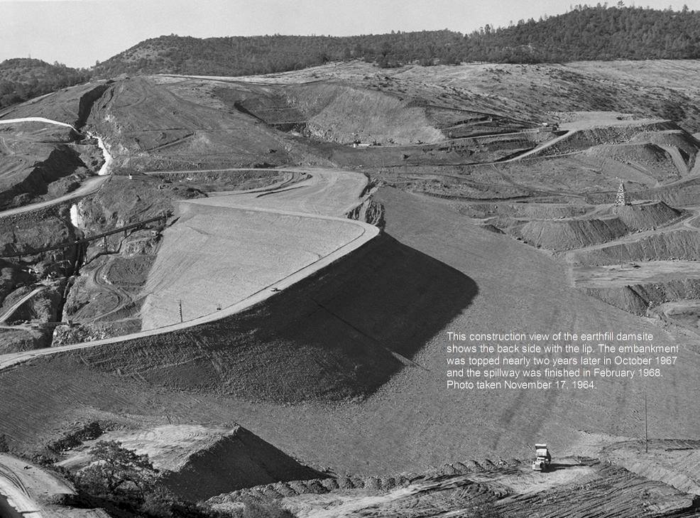
Historic photo during 1964 ... the final top of dam I believe is top of hill to left of the big cut in hillside (which are I believe the water intakes below the main spillway.
The reservoir side of the dam when finished curves just barely to left as viewed in pic below. The main spillway is appx top of existing hill above and just behind the cut.
The emergency spillway follow the cleared upslope from above the cut to the right and the parking lot is appx at tree line as slope flattens from right to left ...
SFX
Member
Home Video shows construction work, from a long way off, but you can see the machinery and a lot of rocks.
Source: https://www.youtube.com/watch?v=ux9MSHoVL2g
[Mod: replaced with original video]
Source: https://www.youtube.com/watch?v=ux9MSHoVL2g
[Mod: replaced with original video]
Last edited by a moderator:
Scott Gates
Active Member
I believe these are the appx locations of:
Main spillway RED
Emergency spillway DARK RED
Parking Lot YELLOW
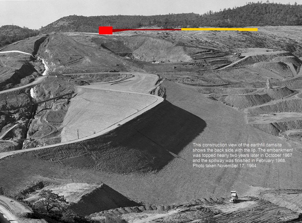
Main spillway RED
Emergency spillway DARK RED
Parking Lot YELLOW
- Status
- Not open for further replies.
Similar threads
- Replies
- 19
- Views
- 6K
- Replies
- 3
- Views
- 7K
- Replies
- 42
- Views
- 7K