Mysterious Helicopter at Skinwalker Ranch (Power Line Survey)

Mick West

Administrator
Staff member
Power line survey helicopter.jpg

In Episode 7 of The Secret of Skinwalker Ranch, a suspicious helicopter is spotted flying over the ranch. Despite having binoculars they failed to identify it, and said it did not show up on the ADS-B scanner.

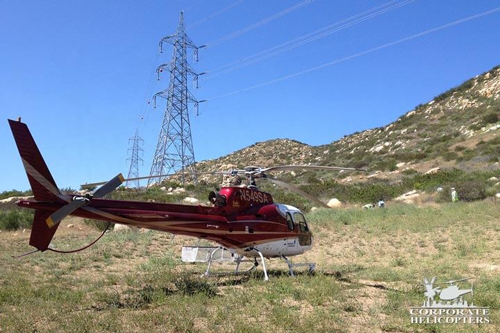
[Update] I contacted Corporate Helicopters. Ivor Shier, the director of operations, called me back and confirmed it was their helicopter and that they were just doing a LIDAR powerline survey. This is looking for things like defects in insulators and encroaching vegetation - anything that might be a fire hazard. He said that's all it was. He said they don't turn off the ADS-B, but that area has very poor receiver coverage. They don't rely on only FlightRadar24 style ADS-B, but also have TracPlus monitored from the head office, and also by the powerline company. He sent me some photos:
unnamed-3.jpg

unnamed-2.jpg

unnamed-1.jpg

[Previous investigation follows]

Metabunk 2020-05-21 08-25-30.jpg


After a bit of poking around, I think it's this one:

ac1590007527884079.jpg

N545SA, a Bell 206L3

Dates in the show are unclear as they falsify the on-screen dates to provide a narrative timeline (this episode starts with a label August 16,2019). But we know for sure from some dates shown in monitors that some of it was filmed in August 2019. Around that time 5SA was flying out of Provo, Utah, about 100 miles from Skinwalker Ranch.
Metabunk 2020-05-20 14-01-13.jpg
I downloaded the available tracks, but coverage seems a bit limited. But there were several partial tracks.
Metabunk 2020-05-20 14-13-33.jpg

The Helicopter was heading towards the ranch at 15:54 UTC Aug 22 2019, which in Utah time is 9:54 AM. It's 67 miles away
Metabunk 2020-05-20 14-16-29.jpg

At 19:47 UTC (11:47 AM) it shows up again 43 miles to the East, almost directly on the other side
Metabunk 2020-05-20 14-25-11.jpg

So presumably would have flown over the ranch at some point.

What was it doing? What is it flying over.
Metabunk 2020-05-20 14-26-20.jpg

Power Lines.

Metabunk 2020-05-20 14-29-26.jpg

Metabunk 2020-05-20 14-31-46.jpg

And those power lines run just a mile north of the ranch, so the helicopter, surveying powerlines, would have flown right over the mesa.

The helicopter is owned by Corporate Helicopters, who lease it out to power companies
https://www.corporatehelicopters.com/helicopter-services/helicopter-utility/aerial-mapping/
Metabunk 2020-05-20 17-00-40.jpg

Monitor powerlines helicopter

In the show at 06:10 there's a better shot of the helicopter.

Metabunk 2020-05-21 08-36-54.jpg
6-10 helicopter.jpg

Comparing the number to a blurred version of the chopper, we can see it's A) there, and B) consistent with being the same number N545SAhelicopter number compare.jpg

And here's another shot, maybe better;

Metabunk 2020-05-21 08-44-10.jpg
 
Last edited:
To find the helicopter, I did a bunch of Googling of "helicopter survey Utah" and suchlike, but was only able to determine it was some kind of Bell helicopter.

Then I took this image:


And search for it in Yandex, which does a good job of finding similar images. I noticed this result:
Metabunk 2020-05-20 16-47-16.jpg

Which led here:
https://www.haber3.com/foto-galeri/haber/muhsin-yazicioglunun-helikopteri-dustu-galeri-4538236
Metabunk 2020-05-20 16-51-10.jpg

I then did a search with one of those images. This let me determine it was a Bell 206-L3, based on this image that cropped up:
Metabunk 2020-05-20 16-55-36.jpg
(From which I just searched the N80TV number)

Finally an image search for "bell 206L-3 survey" gave the actual helicopter, identified by the paint scheme and black box underneath.
Metabunk 2020-05-20 16-57-44.jpg

And then I simply typed the number into FlightRadar 24, and scrolled down until I saw something with a Utah airport. Bingo.
 
Last edited:
In the show, one of the cast members goes inside to check if there was ADS-B transponder data. He does not find any, and so they conclude that the helicopter has switched off its transponder for privacy.

This makes no sense because they could quite easily see the number on the side of the helicopter that would identify it.

But why no transponder data?

There are two ways you can get ADS-B data - either from your own ADS-B receiver or from a network of ADS-B receivers, like the one used by Flightradar24. These networks are largely set up by volunteers, and so are clustered around areas of high population - which is not what Skinwalker Ranch is.

In this case, we DO have ADS-B data, just on either side of the ranch. Just not in the middle, probably because of the lack of local ADS-B receivers in the FR24 community.

Another problem is that low altitude aircraft are often not found - especially in hilly terrain. So you get great coverage for hight up planes. but very poor coverage for planes in rural areas.

So, if they were using FR24 (or similar) then it was not found because they are in the middle of nowhere. If they had their own ADS-B receiver, then by the time they looked it was obscured by the mesa, or perhaps just never picked up at all.

It's kind of a moot point though - because this was the helicopter, it's a powerline surveying helicopter, and that's what it was doing.
 
Something else important: ADS-B coverage isn't 100 percent of the national airspace and varies with airspace class. Skinwalker Ranch is in Class E airspace, which means that below 10,000 feet ADS-B is not required.
 
Skinwalker Ranch is in Class E airspace, which means that below 10,000 feet ADS-B is not required.
The helicopter did have ADS-B on both earlier and later. I'm presuming they did in the middle too, it was just not picked up. Besides the low population density (and hence lack of ADS-B receivers) it was also flying low in a mountainous region. About 2000' above ground level near the start. Lower than the surrounding hills.

Metabunk 2020-05-21 07-28-20.jpg

Viewing it within FR24 shows even those partial tracks have missing sections - like flying through the canyon here:
Metabunk 2020-05-21 07-46-42.jpg

It seems to keep a fairly constant 2,000 feet AGL.
Metabunk 2020-05-21 07-59-38.jpg
 
Last edited:
I've not watched any of the Skinwalker Rancher episodes, as I'm afraid it would rot my brain. However, if they're reacting to a perfectly ordinary looking commercial helicopter with more than a "hmmm, helicopter... cool I suppose" then it puts them on the same level as the ghost hunting shows where the slightest creak or smell of mildew in an old house, is treated as a mysterious event.

Maybe they should get Scooby and the gang on the case, to see if that helicopter's been hired by any local gold mine owners, or circuses.
 
I contacted Corporate Helicopters. Ivor Shier, the director of operations, called me back and confirmed it was their helicopter and that they were just doing a LIDAR powerline survey. This is looking for things like defects in insulators and encroaching vegetation - anything that might be a fire hazard. He said that's all it was. He said they don't turn off the ADS-B, but that area has very poor receiver coverage. They don't rely on only FlightRadar24 style ADS-B, but also have TracPlus monitored from the head office, and also by the powerline company. He sent me some photos:

unnamed-2.jpg
unnamed-3.jpg

unnamed.jpg
 
Kinda makes me wonder how good these paranormal investigators are if they already fail at investigating normal phenomena.
 
If you know where the ADS-B receivers are in that area you can use STK to model the flight path and check if the terrain will cause interference.
 
The bell longranger N545sa is not patrolling power lines. There is not a power line within 4 miles of me and they were circling my place over and over. When I called there office they said they were not aloud to tell me what they were doing... alway a good sign! I fly these things and worked power lines in Pennsylvania in the late 70’s and all that is needed is a thermal scanne, whatever all that crap that is bolted on is not flir period. The insulators get smog attached to them and start resistance which in turn creates heat which is why you only need color flir these days. You cannot create a fire 200’ in the air. It’s to keep the metal tower itself from going to ground and running 600,000 volts through some hiker who decides to take a piss.
 
I fly these things and worked power lines in Pennsylvania in the late 70’s and all that is needed is a thermal scanne, whatever all that crap that is bolted on is not flir period.
I talked to Ivor Shier the director of operations, and he explained that they also use LIDAR now.

Consider that 40 years have elapsed since you did it.
 
Back
Top