Measuring the Curvature of the Horizon with a Level

Assuming you were standing in the middle of the disk. Which you always (kind of) are on a sphere (the "disk" being in the plane formed by the horizon)
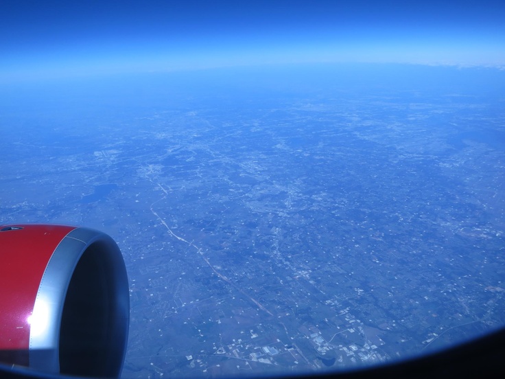
Yes, I meant for staying in the same place horizontally and gaining altitude.

But that's also a good point - on the flat Earth, the horizon would be closer to you in one direction, depending where you were in relation to the edge.
 
On the Flat Earth model you would never see the horizon, as it's too far away. The existence of a horizon like we see here requires either some strange bendy light and/or a gross misunderstanding of perspective.

In fact the simply observations of the sharp horizon seen in this thread, together with the observation that the horizon recedes as you get higher, should be sufficient to demonstrate the curvature of the ocean.
 
What would we see, then ? I always wondered. Would the distant land be blurry or something ?

From an airliner at 35,000ft the horizon is about 230 miles away, and it's pretty hard to see where it is, due to the atmosphere.


On a flat Earth, the horizon would be wherever the Earth stopped, ie the edge of the disk, which would be thousands of miles away from most places, certainly most inhabited places (the Flat Earth Society says the flat Earth is 25,000 miles in diameter). If 200-odd miles of atmosphere can blur the horizon to that extent, then it's fair to assume you wouldn't be able to see a sharp horizon from thousands of miles away.

Of course, that is complicated by the fact that on a flat Earth you wouldn't be looking "over" nearby hills etc, so in practice your horizon would be limited by the visual high points of land in any given direction. Without any curvature, these would probably be reasonably close to you: you couldn't say, for example, that you ought to be able to see all the way to Mount Everest because nothing is higher, as a modest nearby hill (or even building) would present a visually higher angle.

But on a flat Earth you would never be able to look out at the open ocean and see a sharp horizon: the atmosphere would basically blur the division between land and sky into invisibility.
 
So I just found a quick and easy way to debunk all the "Horizon is Flat, where is the curve" images using your method of compression on MS Paint.


Take the image, and resize it horizontally by 1-5%


Zoom in and witness the curve. The red line is a pixel perfect straight line as a reference.

 
So I just found a quick and easy way to debunk all the "Horizon is Flat, where is the curve" images using your method of compression on MS Paint.
You have to be careful to isolate any distortion due to the camera lens, though, which can often be greater than the actual visual curvature of the horizon.
 
You have to be careful to isolate any distortion due to the camera lens, though, which can often be greater than the actual visual curvature of the horizon.

I understand, im new to the debunking scene and my knowledge of photography is very limited.
 
Take the image, and resize it horizontally by 1-5%

I prefer to crop it first, then resize vertically to 1000% (10x). That way you don't lose any pixels. Take your image from here:
https://cdn.barnimages.com/wp-content/uploads/2015/07/JM0107_BarnImages-14.jpg

Use the Crop tool:
20170518-071135-tn0ea.jpg

Images size, Turn off the constraint (the chain link icon), height to 1000 Percent
20170518-071344-l0j6r.jpg

Gives you this:
20170518-071815-4d3bp.jpg
Small but noticeable curve.

If the image is sufficiently large, and the horizon is sufficiently sharp (generally from a low altitude, like this seems to be) you can use a large percentage, or just repeat the process. This is 100x. I also boosted the contrast:
20170518-072027-w30zh.jpg

While it does not prove anything without a straight edge parallel to the horizon (to correct for lens distortion), it DOES debunk:
all the "Horizon is Flat, where is the curve" images

And if you can get someone to understand what they are seeing, then it's a good illustration of how slight the horizon curve actually is.
 
A few weeks ago I was trying to discuss using a level with someone on twitter:

Source: https://twitter.com/MickWest/status/858769654071742464


However he went in a different direction, and then went viral, becoming the subject of much mockery.
http://www.iflscience.com/environme...ent-goes-viral-just-not-in-the-way-hed-hoped/

20170521-100917-qp9dk.jpg
Unfortunate, but it will be interesting if it has any effect on anything, either making people think about what "level" actually means, or some kind of backfire effect.
 

Attachments

  • 20170521-100631-81og9.jpg
    20170521-100631-81og9.jpg
    175.7 KB · Views: 604
Do we have the maths for this somewhere?

I just used the distance to the horizon on a regular globe from 360 feet. But actually I guess that's not correct as you'd have to add the drop, so you'd be 360+352 feet above a similar flat disk.
 
So I was walking in the hills and came across a bunch of junk that included some long things with straight edges:

IMG_2292.JPG

IMG_2263.JPG
I had a revisit with those photos I'd taken to try and show the curve and realised where I'd gone wrong: I wasn't directly 'straight on' with my level. My compression image, therefore, shows pronounced effects of perspective on the straight edge:

IMG_2292.JPG

Just in case anyone else wants to do the same: a mistake I made to be avoided.
 
The astronomical horizon would be the same as the true horizon on a very large or infinite disk earth. But here on the sphere earth they are not the same. The difference is the dip of the horizon, and the dip increases with observer altitude.

Would the 25.000 miles disk FEs propose be large enough? (I'd assume yes, since the horizon - ie the edge of the disk - would be far far away from most points of the disk)
 
Would the 25.000 miles disk FEs propose be large enough? (I'd assume yes, since the horizon - ie the edge of the disk - would be far far away from most points of the disk)
Rough calculations...

Assuming the radius is 12,500 miles (diameter 25,000 miles), then about 85% of the area of the Earth would be at least 1,000 miles from the rim (ratio of 11,5002​/12,5002​ = 84.6%).

From a decent sized mountain, say 10,000 feet (about 2 miles), located 1,000 miles from the rim, the dip would only be about arctan(2/1000) = 0.11 degrees. For comparison, on the globe Earth, the dip of the horizon from a 10,000ft mountain is 1.77 degrees.
 
Many people who are aware that we live on a globe still confuse this as they think that there is no curve at all at low altitudes. These images confirm that the curve is present always except one special case of optical distortion in a 360 degree simultaneous image.

I have posted the following to non-flat earth believers and they still seem to think it is not true :

This one seems to confuse many people horizon is always flat 360 degrees around you No, the horizon is not flat at any height or at any angle of view other than 360 degrees. A 360 degree simultaneous view or image will show the edge (horizon) of every sphere of every size distorted to be totally flat no matter how high up or low it is viewed when the 360 degree image axis is in alignment with the spheres' center, as would be the case on a hypothetical earth horizon image. There is no other geometric possibility. At any distance or height relative to any size sphere, the entire horizon or entire visible edge of that sphere is equidistant to the observer.

The earth sphere is so incredibly large that the curve is incredibly small and thus is not perceptible at low altitude and especially for human perception with the eye having a 55 degree angle of view, but it is there. This is geometric fact. If we increase the angle of view with a rectified optical lens device, then the curve will be more pronounced even at low altitude. Higher altitudes will be easier to see a curve even with a narrow angle of view, obviously.

One can photo the horizon of the ocean and detect the curve even at low heights and see the curve by a high resolution image squeezed horizontally or by drawing a straight line across the horizon. Of course the image must be sharp, on a clear day at best focus on the ocean horizon and of an adequately high resolution But if done right, it can be detected. It has been done(on this page here)

If one were to make a 360 degree view lens it would be convex vertically and the glass would curve 360 degrees with the light recorded inside that enclosed lens. The shutter would be 360 also. One could more easily use a chemical film wrapped cylinder instead of a curved CCD or CMOS image sensor. That 360 degree image taken of ANY spherical object no matter how large or small or at any height would be distorted to an absolute flat line in that image as long as the image axis is in alignment with the spheres' center, as the edge of any sphere 360 degrees from any position relative to that sphere is by geometrical definition equidistant and thus would appear absolutely flat. So the short answer is THE HORIZON OF ANY SPHERE OF ANY SIZE AT ANY HEIGHT VIEWED 360 DEGREES SIMULTANEOUSLY IS ABSOLUTELY FLAT. Again this is geometrical, optical fact as in no other possibility exists.​
 
Last edited by a moderator:
These images confirm that the curve is present always except one special case of optical distortion in a 360 degree simultaneous image.

While it's technically always present, it's very difficult to detect at very low altitudes - like at the beach. The problem is that a lot of Flat Earther's still try at the beach.
20170731-081859-u9r7y.jpg


So telling them "the curve is always present", is probably not helpful, as they will go look for it at the beach, not find it, and declare the world is flat.

They need to be higher up. Like 500 feet up.

[EDIT] and of course the curve over the horizon is still there, and very detectable from the beach. Just not the visible curve of the horizon, which is a very different type of curve.
 
Last edited:
Unfortunately many people arguing FOR the globe have this idea that the horizon is literally flat

While it's technically always present, it's very difficult to detect at very low altitudes - like at the beach. The problem is that a lot of Flat Earther's still try at the beach.
20170731-081859-u9r7y.jpg


So telling them "the curve is always present", is probably not helpful, as they will go look for it at the beach, not find it, and declare the world is flat.

They need to be higher up. Like 500 feet up.

[EDIT] and of course the curve over the horizon is still there, and very detectable from the beach. Just not the visible curve of the horizon, which is a very different type of curve.

Thanks. I hear you about fine details in discussion with flat earth believers. I am finding, however, many people arguing for the globe are saying that it is flat until a certain altitude. I thought this to be in geometrical error but could not find it specifically addressed in searches. after working it out in a 3d modeling program it became apparent that it is always curved, but this hypothetical special case of somehow capturing a 360 degree simultaneous image came to mind. I still was not sure. Thanks for the verification and help in this debunking...or at least straightening out this detail for those assuming this errant notion that there is no curve at low altitudes.
 
Last edited by a moderator:
many people arguing for the globe are saying that it is flat until a certain altitude
I think they are arguing the horizon LOOKS flat to the naked eye until you get to a certain level. Unfortunately this seems to be based more on mathematic than experience. As you get higher the horizon is less and less distinct because of the atmosphere. There's a huge section (depending on weather), from maybe 2,000 to 30,000 feet where you generally can't see the horizon well enough to tell if it's curving. Even as you get higher you are not generally seeing the ocean horizon, but the curve of the tops of clouds, and then of the atmosphere itself.
 
Have I posted a link to this paper before?

http://thulescientific.com/Lynch Curvature 2008.pdf

They conclude that:
- The minimum altitude at which curvature of the horizon can be detected is at or slightly below 35,000 ft, providing that the field of view is wide (60°) and nearly cloud free.
- Interviews with pilots and high-elevation travelers revealed that few if any could detect curvature below about 50,000 ft.
- Many commercial pilots report that from elevations around 35,000 ft they cannot see the curvature.
- The high-elevation horizon is almost as sharp as the sea-level horizon, but its contrast is less than 10% that of the sea-level horizon.
- Photographs purporting to show the curvature of the Earth are always suspect because virtually all camera lenses project an image that suffers from barrel distortion.
Content from External Source

All true, but it's worth pointing out that these are observations/detections of the curve of the horizon with the naked eye and no aids.

At low altitudes (under 1000 feet) you can detect the curve of the horizon in at least two ways:
  1. With the naked eye and a sufficiently long straight level line - such as a taut string, or a long carpenters level. You can then observe the horizon being lower at the edges than at the middle (when viewed from a point opposite the middle)
  2. By taking a wide angle photograph with a rectilinear lens and stretching it vertically (as above). Preferably this would also include a straight level line such as in #1
 
All true, but it's worth pointing out that these are observations/detections of the curve of the horizon with the naked eye and no aids.
Agree with that.
You can [...] observe the horizon being lower at the edges than at the middle (when viewed from a point opposite the middle.
I'm still not 100% clear on this. First, that when we talk about "the curvature of the horizon", there seem to be two different curves: the curve that one would see when sufficiently distant/elevated (like the outline of a ball, which is what that paper seems to be talking about); and the curve formed by looking down on the arc of the horizon (the "edge of the coin", the measuring of which is what this thread is about). And second, that the curve, in the latter case, isn't formed by the middle being 'higher', but because we're looking at the edge of a circle (I imagine the middle as being 'further away' rather than higher - further away from shore, not the observer - though it will appear 'apparently higher' in a photograph).

Hope that makes sense. It's hard to be clear about something I'm not clear about. ;)
 
Last edited:
Agree with that.

I'm still not 100% clear on this. First, that when we talk about "the curvature of the horizon", there seem to be two different curves: the curve that one would see when sufficiently distant/elevated (like the outline of a ball, which is what that paper seems to be talking about); and the curve formed by looking down on the arc of the horizon (the "edge of the coin", the measuring of which is what this thread is about). And second, that the curve, in the latter case, isn't formed by the middle being 'higher', but because we're looking at the edge of a circle (I imagine the middle as being 'further away' rather than higher - further away from shore, not the observer - though it will appear 'apparently higher' in a photograph).

Hope that makes sense. It's hard to be clear about something I'm not clear about. ;)

Think about the horizon as the base of a cone. or a part of it, with the apex at the centre of the lense of an ideal camera. Think of a pinhole camera.. On the inside of the camera you get an image of the cone which intersects the plane of the sensor. The curve you get is a conic section which can be a circle if you are out in space and pointing at the centre of the earth. For part of a very shallow cone, that the horizon would form with a camera at the top of a small hill, the curve on the image would be a hyperbola, assuming an 'ideal' camera with a flat focal plane.
 
Last edited:
I'm still not 100% clear on this. First, that when we talk about "the curvature of the horizon", there seem to be two different curves: the curve that one would see when sufficiently distant/elevated (like the outline of a ball, which is what that paper seems to be talking about); and the curve formed by looking down on the arc of the horizon (the "edge of the coin", the measuring of which is what this thread is about).
No, they are the same thing. The horizon is always a "flat circle", in as much as it is the same distance from your eye and the same elevation below it all the way round. So the curvature you see is always the "edge of the coin" curve caused by looking down on this flat circle.

It's simply that as you get higher and higher, the size of this circle gets bigger and bigger, and further and further below you, until at the extreme case when you are way out in space, the circle of the horizon is almost the same as the circumference of the Earth. (It will never quite be the same until you are at infinite distance away.)

The shift between the two is a perceptual one, really. If you play around with Google Earth slowly increasing your altitude, there's a point where your brain suddenly flips from "I'm looking at the edge of a circle" to "I'm looking at a ball", but nothing has really changed, it's just to do with how much of the horizon fits in your field of view, and whether you feel as if you're looking "out" or "down". (On GE this is artificially limited by the screen size, of course.)
 
Last edited:
Think about the horizon as the base of a cone. or a part of it, with the apex at the centre of the lense of an ideal camera. Think of a pinhole camera.. On the inside of the camera you get an image of the cone which intersects the plane of the sensor. The curve you get is a conic section which can be a circle if you are out in space and pointing at the centre of the earth. For part of a very shallow cone, that the horizon would form with a camera at the top of a small hill, the curve on the image would be a hyperbola, assuming an 'ideal' camera with a flat focal plane.

ps. The title of this thread should probably be changed to 'observing' rather than 'measuring' since the curve seen/photographed is not readily convertible to the radius of a sphere.
 
ps. The title of this thread should probably be changed to 'observing' rather than 'measuring' since the curve seen/photographed is not readily convertible to the radius of a sphere.

i'd thought of it as measuring how much the horizon appears to curve in the image, rather than the radius of a sphere.
 
No, they are the same thing. The horizon is always a "flat circle", in as much as it is the same distance from your eye and the same elevation below it all the way round. So the curvature you see is always the "edge of the coin" curve caused by looking down on this flat circle.

It's simply that as you get higher and higher, the size of this circle gets bigger and bigger, and further and further below you, until at the extreme case when you are way out in space, the circle of the horizon is almost the same as the circumference of the Earth. (It will never quite be the same until you are at infinite distance away.)

The shift between the two is a perceptual one, really. If you play around with Google Earth slowly increasing your altitude, there's a point where your brain suddenly flips from "I'm looking at the edge of a circle" to "I'm looking at a ball", but nothing has really changed, it's just to do with how much of the horizon fits in your field of view, and whether you feel as if you're looking "out" or "down". (On GE this is artificially limited by the screen size, of course.)

I think a good visual demonstration would be to take a ball, draw a circle on it to represent the horizon and then use that line as a guide to cut a slice off. Then put that slice down on a flat surface. I'm not really set up to do a decent job of it but I had thought a polystyrene ball with a hot wire to cut it would do it
 
No, they are the same thing. The horizon is always a "flat circle", in as much as it is the same distance from your eye and the same elevation below it all the way round. So the curvature you see is always the "edge of the coin" curve caused by looking down on this flat circle.

It's simply that as you get higher and higher, the size of this circle gets bigger and bigger, and further and further below you, until at the extreme case when you are way out in space, the circle of the horizon is almost the same as the circumference of the Earth. (It will never quite be the same until you are at infinite distance away.)

The shift between the two is a perceptual one, really. If you play around with Google Earth slowly increasing your altitude, there's a point where your brain suddenly flips from "I'm looking at the edge of a circle" to "I'm looking at a ball", but nothing has really changed, it's just to do with how much of the horizon fits in your field of view, and whether you feel as if you're looking "out" or "down". (On GE this is artificially limited by the screen size, of course.)
Yes, I was going to say something about how, actually, they do seem like the same thing, just the different scale of each makes them appear different.

Moreso, though, what about the curve not being as a result of the middle of the horizon being "higher" than the edges?
 
Last edited:
I've been looking into the graphic representation of Earth's Curve Horizon, Bulge, Drop, and Hidden Calculator and I've noticed that for a viewer the horizon is actually higher and closer than the Earth's bulge or at least that is what the graphic indicates.


Horizon Height.jpg

If that is the case:

What is the formula to calculate the height of the horizon?
And could you please update the calculator if the horizon is indeed higher and there is a formula?
 
I've been looking into the graphic representation of Earth's Curve Horizon, Bulge, Drop, and Hidden Calculator and I've noticed that for a viewer the horizon is actually higher and closer than the Earth's bulge or at least that is what the graphic indicates.

It simply depends on how high the viewer is.

The "bulge" point is just the midpoint between the viewer and the target object.
The horizon can be anywhere between the viewer (like if you have your eyes at sea level, like actually laying down with the water up to your eyeballs), to (or beyond) the target object.

Here's an interactive version. You can click on the "Camera" and the "Target" and see how things move.
https://www.geogebra.org/material/iframe/id/1153831

Notice that the "bulge" does not change with view height, but the horizon does.

And both points are at the same height: sea level.
 
Here is a good example of a side view of Earth's curvature from sea level.

Image without zoom:

No Zoom.jpg

With slight zoom:

After zoom.jpg

You can clearly see that from left to right the horizon is rising:

Eye level.jpg

A bit more to the right I panned the camera at a lighthouse which is 11.4 miles away obscured by Earth's curvature.
The bottom of the image is where the beach ends and the sea begins:

Eddystone Eye Level.jpg

And we still see that the horizon continues to rise from left to right:

Eddystone Still Rising.jpg
 
Last edited:
Back
Top