Measuring the Curvature of the Horizon with a Level

Last edited by a moderator:
I think this method should work with the aid of a jig, better weather, and more altitude. The level is 122 cm. long and about a metre away, if anyone wants to work out my altitude..

horizon2.png
I don't see how you could work out the altitude as it would be so sensitive to differences of height between the camera and the level. I like the idea of trying to see curvature compared to a level but I suspect barrel distortion would be more evident than real curvature over that sort of distance.
 
I don't see how you could work out the altitude as it would be so sensitive to differences of height between the camera and the level. I like the idea of trying to see curvature compared to a level but I suspect barrel distortion would be more evident than real curvature over that sort of distance.

I like the "keep it simple"ness of the method. If the horizon is photographed very close to the straight edge, and in the cetnre of the photo, the distortion of the lense should apply equally to both to first order. Also refraction should be the same along the length of the horizon (over sea), therefore the difference in curvature between horizon and straight edge is real. Calculating the diameter of the earth knowing the altitude, or the altitude knowing the diameter, is a little more complicated but seems possible. I think the curve is the intersection of the cone of the horizon with the plane of the camera sensor. https://en.wikipedia.org/wiki/Conic_section

ps. There are two photos above where only one variable has been significantly changed (alitude).
 
Last edited:
A bit more contrast:

20160813-085626-l8dtl.jpg

I suspected at first that what you are seeing here is the level slightly tipped to the right, and the horizon on the right obscured by the headland:
20160813-090052-tefa8.jpg

However, trying to simulate the same view in Google Earth gives:
20160813-090657-jlmxj.jpg

Compressed 20x:
20160813-090946-na6of.jpg

Overlaid:
20160813-091342-sx1nf.jpg

A very good match! Seems like the world is round after all!
 
I had been thinking recently that any wide-angled, suitably elevated, high-res photo of the horizon ought to show some sign of curvature when looked at in extreme close up using software. I mean, even if it showed only a few pixels' worth of deviation from a straight line, doesn't that illustrate the point, and achieve the same result as the above?
 
Using a 20x compression on the low photo:
20160813-092737-tx0eg.jpg
I think it's safe to say there's some distortion here. But also that the horizon seems a pretty consistent height above the level, and if where there is variation it's linear, as you would expect from a very low viewpoint, and the level dipping a bit at the right

Here I've attempted to correct the distortion manually:
20160813-093206-0q17n.jpg

And an additional 10x compression, with more manual adjustment
20160813-093607-leyim.jpg

Roughly linear
 
I had been thinking recently that any wide-angled, suitably elevated, high-res photo of the horizon ought to show some sign of curvature when looked at in extreme close up using software. I mean, even if it showed only a few pixels' worth of deviation from a straight line, doesn't that illustrate the point, and achieve the same result as the above?

Not exactly, you need to use a straight edge (and preferably a level) to correct for any lens distortion. Even nominally rectilinear lenses have some distortion, and many cheaper lenses have lot.

However suitably high and wide photos, with the horizon centered, should show curvature when compressed.
 
Here's a good one,
Lunada Canyon, Rancho Palos Verdes, California.
33.767482853°, -118.408898009°
https://nobodyhikesinla.com/2010/12/06/lunada-canyon/


20x compression (using photoshop, 25% width, 500% height, unconstrained aspect ratio)

20160813-094442-nnkgz.jpg

As the horizon is very well centered here, I think this probably is showing the curvature of the horizon.

Replicating in Google Earth

20160813-112821-rsvsr.jpg

20160813-113537-bly4y.jpg

20170625-114756-gom46.jpg
 
Last edited:
You might want to test for the dip of the horizon instead. This would test the FE claim that "the horizon is always at eye level." By which they mean to say the earth must be a flat plain rather than a sphere.


You already have a good spirit level. Set up a sheet of Masonite on saw horses perfectly parallel with the ground. Stand behind the level board and lower your eye until you are looking along the top of the board - your line of sight is perfectly parallel to the ground you are standing on.

You won't be able to see the horizon. The horizon will be below your line of sight.

You will be looking at what's called the "astronomical horizon." You've set up the board perpendicular to a line from the center of the earth to the zenith.

The true horizon is the plane that touches the surface of the earth perpendicular to the radius of the earth.


The flat earth claim that "the horizon is always at eye level" is muddled and untrue. What they probably are trying to say is: If your line of sight is perfectly parallel to the ground you are standing on, the horizon is always level with your line of sight. It's impossible to know that your eyes are in that position, of course, especially since the ground you stand on is uneven. They simply look at the horizon, and of course it's in the middle of their field of vision, therefore it's at eye level. They even claim this is true when looking at photos.

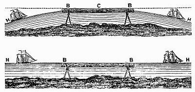
But it's untrue anyway. The dip of the horizon has been known about and studied for at least a thousand years.

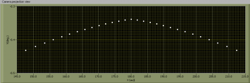
The astronomical horizon would be the same as the true horizon on a very large or infinite disk earth. But here on the sphere earth they are not the same. The difference is the dip of the horizon, and the dip increases with observer altitude.

As matter of fact an 11th century Persian astronomer measured the dip of the horizon from sea level and from the top of a mountain and used that difference to calculate the radius of the earth.

https://en.wikipedia.org/wiki/History_of_geodesy#Al-Biruni

There has been some skepticism about the accuracy of his findings because Al-Biruni didn't know about Snell's law.


Complication:

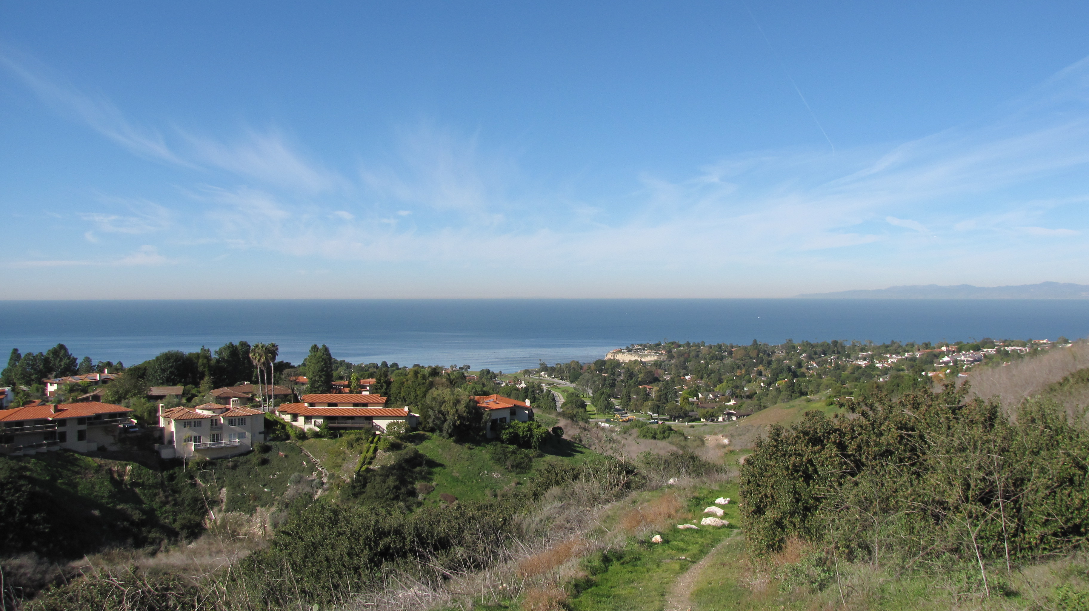
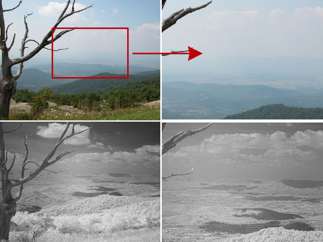
The geographic horizon is the boundary between earth and sky - in your case the boundary between sea and sky. (Confusingly the boundary between sea and sky is often called the true horizon, as opposed to a cluttered horizon you get on land.) The geographic horizon is not exactly the same as the true horizon because the earth has an atmosphere. Even in standard-atmosphere conditions refraction makes the geographic horizon somewhat lower than the true horizon. When there are steep temperature gradients in the atmosphere, refraction can really play tricks with the geographic horizon.
 
As matter of fact an 11th century Persian astronomer measured the dip of the horizon from sea level and from the top of a mountain and used that difference to calculate the radius of the earth.

https://en.wikipedia.org/wiki/History_of_geodesy#Al-Biruni

There is no dip at sea level (i.e. with your eye level wth the water). He only measured the dip from the top of the mountain, and then used the height of the mountain (which he calculated by other means) to calculate the radius.

As I mentioned in another post, some cameras have a level built in. One could just go to the top of a mountain with a view of the sea, and then measure the dip. If the height of the mountain is not contested you could then find the radius of the Earth. It seems fairly sensitive.
20160813-131959-rr6ot.jpg

And of course you could use an iPhone
 
There is no dip at sea level (i.e. with your eye level wth the water). He only measured the dip from the top of the mountain, and then used the height of the mountain (which he calculated by other means) to calculate the radius.

Yes, you're right of course. Sloppiness of language on my part. A reconstruction of his methods is presented in this documentary. (I've time stamped it.)


I also should have said that "Clouds Givemethewillies" should be standing as high as possible. There are some pretty good cliffs in the area.

This is the formula that I've found. I can't vouch for it: dip (minutes) = 0.531 √h (feet)

I'm not sure the experiment with the Masonite would be practical. But my main point is that very few flat earth believers have heard of the dip of the horizon, and will deny that it exists when told about it. They cling onto the horizon is always at eye level thing.
 
Last edited:
It's very interesting that this method was suggested back in 1872 in the first edition of The Zetic,
http://www.theflatearthsociety.org/library/pamphlets/Zetetic, The (Vol. 1, No. 1, July 1872).pdf


20160814-103107-o6xo7.jpg

The math and reasoning there are wrong in the way they think the horizon should be curved. However it is actually curved, and yet they claim that what is observed is a flat line.

It's especially interesting because they were just using the naked eye to make the observation. Now with the advent of digital photography and the technique (seen in above posts) of horizontally compressing the image, the actual curvature of the horizon is more readily apparent.

One could actually replicate this experiment with nothing more than an iPhone or similar modern camera. Just go to any clifftop walk and use the railings in place of the level. Just make sure you are perpendicular to them, then align the camera so the tops of the top rails are very slightly below the horizon, and take a picture with the horizon vertically cented in the image to avoid distortion. For example Palisades Park in Santa Monica


(You'd need to get a bit closer)

While the railing are unlikely to be perfectly level, they will generally be straight. The back of a bench would also work well, and are commonly found in cliff-top walks even without fences.

Then you can do the compression on the image (I recommend 20x), and you will see the railing are straight, and the horizon is curved.

This image is too low, but more like what you need.
 
Last edited:
I think about 200 metres is about the limit for me. Above that visibility of the horizon is an issue. The following photos are taken at two nearby locations both DSCF2792 bardsey from banc-y-darren ridge.jpg DSCF2790 bardsey from Bont-Goch ridge.jpg around 200 metres. Although visibility of Bardsey is quite good with the horizon more or less in line with the low lying horizon stretched Bardsey.jpgground at the SW corner, I ran out of contrast to the west..

This editor has a mind of its own!
 
Last edited:
I think about 200 metres is about the limit for me. Above that visibility of the horizon is an issue.

Yes, that's an interesting aspect, as you get higher and the horizon get further away it gets less distinct (which is itself proof of a curved water surface). So it seems like there's probably a sweet spot to do this type of observation, where you are high enough to detect curvature, but not so high that there's no contrast. Weather will obviously play a factor.
 
Yes, that's an interesting aspect, as you get higher and the horizon get further away it gets less distinct (which is itself proof of a curved water surface). So it seems like there's probably a sweet spot to do this type of observation, where you are high enough to detect curvature, but not so high that there's no contrast. Weather will obviously play a factor.

I think sunset might be best, judging by tonight.
 
I'm sorry to say it, but if I was that rarest of beasts, a rationally sceptical flat earther, I wouldn't be convinced by any of the evidence presented in this thead. I recall that we discussed the height from which we could see curvature with the naked eye, and others mentioned the paper I've seen, which came up with the figure of 60,000 feet. OK, here we are looking for measurable curvature, not visibility with the naked eye. Still, I can't help feeling that the variables are just too wide; lens distortion, misplacement of the centre line, fuzzy horizon, not-quite-straight rules and so on. Surely the error overwhelms the likelihood of reliable measurement.

If someone with more mathematical and/ or practical knowledge explains why I'm wrong, I'll believe them. In the meantime, I feel that we should be as rigoroysly critical as we can in what we claim as evidence even when arguing with the flat earther faithful.
It would be easier if only the earth was smaller..
 
I'm sorry to say it, but if I was that rarest of beasts, a rationally sceptical flat earther, I wouldn't be convinced by any of the evidence presented in this thead. I recall that we discussed the height from which we could see curvature with the naked eye, and others mentioned the paper I've seen, which came up with the figure of 60,000 feet. OK, here we are looking for measurable curvature, not visibility with the naked eye. Still, I can't help feeling that the variables are just too wide; lens distortion, misplacement of the centre line, fuzzy horizon, not-quite-straight rules and so on. Surely the error overwhelms the likelihood of reliable measurement.

If someone with more mathematical and/ or practical knowledge explains why I'm wrong, I'll believe them. In the meantime, I feel that we should be as rigoroysly critical as we can in what we claim as evidence even when arguing with the flat earther faithful.

If you look back at post #4, the clearest evidence that we are seeing curvature and not some error is that the compressed image from the clifftop very closely matches the compressed Google Earth image from the same spot:


The effect of lens distortion and being off-center is eliminated (or at least corrected for) by the presence of the level. The horizon here seems sufficiently clear to detect the curve, and levels generally have very straight edges.
The curvature is quite slight. According to my software (with the unmentionable name) the horizon should be 0.34 degrees below horizontal at the centre and appear to be 0.64 degrees below at the edges of the scale. The scale is non-linear (tangent) for larger angles but I think it amounts to about 1220*0.3/60=6 mm. bulge at the centre for 110m ASL. The string of white dots are points on the horizon 2 degrees apart. The upper graph is true elevation v azimuth, and the lower the projection on the camera sensor with the y axis stretched.

Edit. Counting the dots I got that all wrong... I need the droop for about 30 dots, not the whole scale - much less. I will try again!

New graph with ~60deg. span.

1220*0.1/60=2 mm.
 

Attachments

  • 110 metres.png
    110 metres.png
    4.2 KB · Views: 586
Last edited:
If you look back at post #4, the clearest evidence that we are seeing curvature and not some error is that the compressed image from the clifftop very closely matches the compressed Google Earth image from the same spot:


The effect of lens distortion and being off-center is eliminated (or at least corrected for) by the presence of the level. The horizon here seems sufficiently clear to detect the curve, and levels generally have very straight edges.
But in this photo the level is very clearly 'bowed' in the center. Though I imagine that, 'if straightened out', there would still be a visible curvature of the horizon.

I've revisited this because I was thinking of having a go myself. I live near the ocean, a 1200-foot hill, and the visibility is generally very good. Though these advantages may be offset by the fact that, for a camera, I only have an iPhone 4. ;)
 
So I was walking in the hills and came across a bunch of junk that included some long things with straight edges: in a nutshell, I have a load of photographs of the horizon from just over 1000-feet up, like so:

IMG_2292.JPG

IMG_2263.JPG

Unfortunately, I don't have the software or the ability to do the compressing thing. If they're fit for purpose, would anyone like to receive some and give it a go?
 
Pretty inconclusive. The metal(?) grid isn't straight either:

stretched.jpg


Of course, it's important to note that even if we can see curvature of the horizon, it's not the "curvature of the Earth". The horizon doesn't curve up and down at all; the curvature we see is just because the horizon is a circle, and we are looking slightly down on it.
 
Thanks for that. The two images I posted were as samples/examples, but I took plenty of others that may be better used. Unless it's thought fruitless/they weren't good enough?

Cheers.
 
Last edited:
Of course, it's important to note that even if we can see curvature of the horizon, it's not the "curvature of the Earth". The horizon doesn't curve up and down at all; the curvature we see is just because the horizon is a circle, and we are looking slightly down on it.
So are we now saying that all this "measuring the horizon with a level business" is sort of pointless?
 
So are we now saying that all this "measuring the horizon with a level business" is sort of pointless?

No, the visual curvature of the horizon only looks like that from 360 feet on a 4000 mile radius globe earth, or a 23 mile radius flat disk. So it demonstrates one or the other. I think it's a great demonstration of the size and shape of the Earth.

If the earth were flat and thousands of miles across you would not be able to see the horizon.
 
I think it's a mistake to entertain the notion that we could see the earth's curvature by trying to find an "arc" on the horizon. Not only does it confuse the "horizon" with the "edge of a globe," but it actually demonstrates a misunderstanding about the physics at the top of a sphere. Keep in mind, no matter where you may be geographically, you are standing at the top-center of a sphere. As such, all curvature necessarily flows OUTWARD, away from you at every point in a 360-degree circle. All you would be able to see is a 360-degree circled horizon on top of an otherwise flat plain.
 
I think it's a mistake to entertain the notion that we could see the earth's curvature by trying to find an "arc" on the horizon. Not only does it confuse the "horizon" with the "edge of a globe," but it actually demonstrates a misunderstanding about the physics at the top of a sphere. Keep in mind, no matter where you may be geographically, you are standing at the top-center of a sphere. As such, all curvature necessarily flows OUTWARD, away from you at every point in a 360-degree circle. All you would be able to see is a 360-degree circled horizon on top of an otherwise flat plain.

Like I just said:
No, the visual curvature of the horizon only looks like that from 360 feet on a 4000 mile radius globe earth, or a 23 mile radius flat disk. So it demonstrates one or the other. I think it's a great demonstration of the size and shape of the Earth.

If the earth were flat and thousands of miles across you would not be able to see the horizon.

The horizon is curved when viewed from above the surface. It's curved because you are essentially looking down at a disk. This is either because it's the visible section of a sphere, or it's a tiny disk. We know the earth is on the order of thousands of miles in scale, so it's not a tiny disk. So the visible curvature of the horizon demonstrates that the earth is sphere.
 
As such, all curvature necessarily flows OUTWARD, away from you at every point in a 360-degree circle. All you would be able to see is a 360-degree circled horizon on top of an otherwise flat plain.
But the horizon is below you. And on a globe, the further away the horizon is from you, the further below you it is.

So while the circle of the horizon is getting bigger, you are also looking down on it from an increasingly high angle, so it appears more curved.

On a flat Earth, the "horizon" would always be the same distance away from you horizontally, it would be the edge of the disk.
 
On a flat Earth, the "horizon" would always be the same distance away from you horizontally, it would be the edge of the disk.

Assuming you were standing in the middle of the disk. Which you always (kind of) are on a sphere (the "disk" being in the plane formed by the horizon)
 
Back
Top