Las Vegas "sprayed"

ssfor27

Active Member
Dutchsinse is claiming Las Vegas, NV was recently "sprayed" and that the offending trails were "caught on radar".

http://dutchsinse.tatoott1009.com/3052014-metro-las-vegas-sprayed-at-night-caught-on-radar/


https://www.facebook.com/photo.php?...2.106418.296574443728320&type=1&stream_ref=10

https://www.facebook.com/photo.php?...2.106418.296574443728320&type=1&stream_ref=10


No Dutch. What you were seeing is chaff released by military aircraft over central Nevada. There is currently a Red Flag military exercise running from Nellis Air Force Base and it is highly probable participating aircraft released chaff that was later seen by weather radars in the area.

http://www.nellis.af.mil/library/flyingoperations.asp

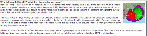
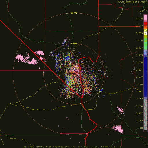
One of the most useful dual polarization weather radar products available is called "Correlation Coefficient" or just CC. In a nutshell, the higher the value is to +1.0, the more "correlated" the objects in that area are; in other words the more they are alike. Rain and snow bands will appear anywhere from a yellow to an almost pink and have a CC closer to 1. Non-meteorological returns such as birds, bugs....chaff....are not very uniform and so therefore their values as seen on weather radar will typically be less than .7 and appear an almost grey or blue.

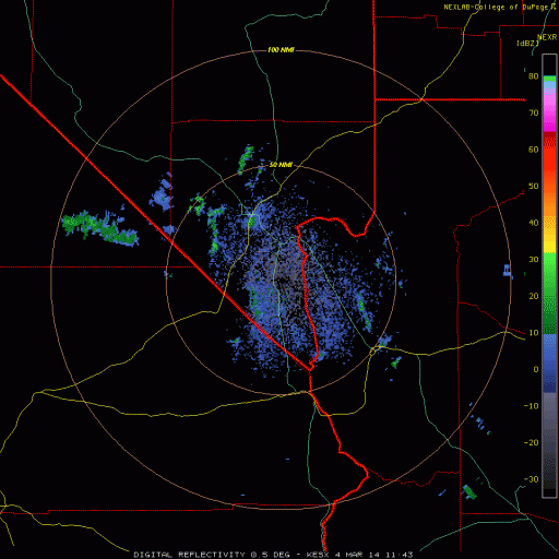
Examining the correlation coefficient product from KESX, the WSR-88D in Las Vegas, we see values of less than .41 and no higher than .73 in Dutch's "spray clouds" - indicating a non-uniformity of the objects in that area, something you'd expect to see from irregularly shaped chaff that is flowing and tumbling through the air.

kesx CC 4 march 14.JPG


As the chaff drifted into southern Utah, it was also picked up by KICX weather radar. Examining the CC from those returns, we continue to see the same values for the chaff. However, southern Utah was also experiencing a precipitation event at the same time and for those returns, we see the pinkish-red returns indicating a value close to +1.


KICX CC 4 March 14.jpg

Just for curiosity, I e-mailed the staff at National Weather Service in Las Vegas and showed them these captures. They confirmed it was indeed a chaff release and that they see it all the time on radar appearing out of both Nellis and Edwards AFB in CA. In addition I asked one of the staff meteorologists here what they thought and they also concurred those are the types of returns and values typically associated with chaff.

Below is a guide to interpreting CC values on weather radar:

CC Values.JPG


I have animated GIF of the event as seen in both base reflectivity and correlation coefficient but am not sure if they will load and then run properly if uploaded here.

A link to the Jacksonville NWS showing an example of chaff on weather radar that looks very similar to the image posted here:

http://www.srh.noaa.gov/jax/?n=interpreting_radar_images

Maybe if Dutch actually knew how to interpret some of the fancy images he loves to post so he can dazzle all his gullible followers, we might actually give him more credit as a real "investigator".....
 

Attachments

  • codnexlab.NEXRAD.ESX.N0Q.20140305.1912.200ani (1).gif
    codnexlab.NEXRAD.ESX.N0Q.20140305.1912.200ani (1).gif
    9.5 MB · Views: 707
  • codnexlab.NEXRAD.ESX.N0C.20140305.1922.200ani.gif
    codnexlab.NEXRAD.ESX.N0C.20140305.1922.200ani.gif
    9.9 MB · Views: 696
Mick - perhaps you could move this to the chemtrails forum and out of HAARP since this is not really a typical Dutchsinse post about "HAARP rings". Thanks!
 
Dutchsinse is claiming...

Oh, not again. The claims made by that person are really very easy to dispute, with facts and science. I am guessing this has been covered already? (I haven't searched MB for this, yet). If not, then this is a good subject for a thorough debunk.
 
He's made multiple posts recently worth debunking. This "Las Vegas spraying" one has not been covered yet to my knowledge.
 
He's made multiple posts recently worth debunking. This "Las Vegas spraying" one has not been covered yet to my knowledge.
Let's get a claim update:
Monday: "Larkspur spraying"
Tuesday: "Larose spraying"
Wednesday:"Las Cruces spraying"
Thursday: "Las Vegas spraying"

Yep, these posts seem right on schedule! ;) (Lathrop, CA… better "Look up!" Friday!)
 
In addition, Dutchsinse ONCE AGAIN demonstrates his utter and complete lack of understanding of any of the imagery he looks at. At approximately the 5:40 and 6:40 marks of his video, he tries to explain to his viewers what the Velocity product shows. He states the purple bands visible are RF or "radio frequency" according to him.


He is either incredibly obtuse or deliberately ignoring what he has been told and shown dozens of times. When viewing velocity products, RF stands for RANGE FOLDING.

rf.JPG

http://forecast.weather.gov/jetstream/doppler/radarfaq.htm#RF

Throughout the video he keeps talking about how there is a "censored version" (quality control) and a version available that shows the "cloud seeding" operation happening, referring to the "censored version" as the "public" feed, apparently implying that he has access to data nobody else does. They are BOTH public feeds Dutch, and have already undergone numerous amounts of re-transmission and filtering before you ever see any of it. Try looking up AWIPS or NOAA Weather wire sometime, you might learn a thing or two about how the imagery you see is distributed before you EVER see any of it.


http://www.nws.noaa.gov/nwws/

http://www.nws.noaa.gov/ops2/ops24/awips.htm

This guy knows absolutely NOTHING about interpreting weather radar except how to bring up fancy looking imagery to try and convince his flock something dastardly is happening.
 

Attachments

  • upload_2014-3-7_11-12-53.png
    upload_2014-3-7_11-12-53.png
    75.2 KB · Views: 641
Yeah, he's pushing that RF thing as if he's really onto something. I know several people have explained to him numerous times backed by multiple sources that RF on doppler velocity maps is "range folded" data. I wonder if he even grasps the concept.

He's got a post on him and his buddy tatoott's 'joint' site (pun intended) where he claims there was a "snownado" somewhere between Shreveport and Little Rock on 3/2/14. He bases this on labels on Intellicast that are the result of an algorithm that automatically displays a warning symbol whenever some kind of rotation is detected in the velocity data. Doesn't mean there's a tornado necessarily, there's rotation involved with convective cells/storms all the time. There were 3, repeat THREE isolated reports of high winds with some minor damage and downed trees in rural LA and MS indicating microbursts from convective storm cells. No reports of tornado's or even hail for that matter. Apparently there wasn't even enough convection to produce notable hail. Often when there are several cells in close proximity their wind fields will interact and the storms will merge and often develop a non-tornadic rotating cloud base or broad rotation within the merged cells. Most likely that's what the Intellicast algorithm picked up in that cluster of convective cells. I don't think there was any snow involved in that system at all, once again he's just making stuff with just enough information to fool his gullible flock.

Here's the three high wind reports from 3/2/14:

 
Just like how many times has he been told that transmitted pulses are not what he is seeing on the imagery he looks at? 10? 15? 100? Once again, in the video posted earlier, he claims the "spray clouds" are being "pulsed". You cannot see a transmitted pulse on radar - that would mean the transmitter is transmitting at the same time the receiver is turned on and that would burn out the receiver. Perhaps he could look up the term "duty cycle".

It also appears he deleted the thread of comments shown below that were under his video earlier this morning. Either that or I am blind. Interesting that any comments that call him out or refer others to this site seem to disappear so quickly. If all of us are quacks and shills, why not let those comments stand?


comments.JPG
 
It also appears he deleted the thread of comments shown below that were under his video earlier this morning.

That means mine is gone, too? Somehow I'm not surprised.

Did you see the post made where the video uploader "dutchsinse" mentioned that he would need to have another "huge fundraiser"? It was under the post suggesting that he use spectrographic and chromatography methods to properly "investigate" his claims and assertions.
I saw that, and assumed it was an attempt at humor...as in "What would a poser do with real scientific instruments?"

The great Phil Hartman (as shyster Lyle Lanley) line from the Simpsons went through my mind:
"You know a town with money is a little like the mule with a spinning wheel.
No-one knows how he got it and danged if he knows how to use it!"
 
Now his latest "confirmation" is about 114 hours after an alleged "haarp ring" off the coast of North Carolina. Of course there were no reports of severe weather on or off shore anywhere in the US on 2/7/14. There doesn't appear to be any sort of severe weather on the radar image he captured, just a band of light to moderate rain, oooohhh but there is one of those auto-generated label thingies that says possible tornado and damaging winds. Doesn't look like much of a 'storm' though but it does correspond in space and time to the approximate center of circulation around a strong surface low. The broad circulation around that low is probably what triggered TWC's algorithm to throw up a warning icon.


Just like how many times has he been told that transmitted pulses are not what he is seeing on the imagery he looks at? 10? 15? 100? Once again, in the video posted earlier, he claims the "spray clouds" are being "pulsed". You cannot see a transmitted pulse on radar - that would mean the transmitter is transmitting at the same time the receiver is turned on and that would burn out the receiver. Perhaps he could look up the term "duty cycle".

It also appears he deleted the thread of comments shown below that were under his video earlier this morning. Either that or I am blind. Interesting that any comments that call him out or refer others to this site seem to disappear so quickly. If all of us are quacks and shills, why not let those comments stand?


comments.JPG

My bad, the comments under that video I thought had been removed are still there..surprisingly. It's pretty common for anything that calls Dutch out or points out the errors in his understanding of things to get deleted quickly.

And Solrey, he had another post a day or two earlier than the one you showed here. He was claiming a "crossing of the beams" (like Ghostbusters maybe?) led to unexpected snow in Kansas.....it was just as ridiculous. Like I said, he's been busy lately.

Indeed! Don't cross the streams. Why? It would be bad...


I've seen that group of radars interfere with each other in the past. I noticed that the interference spikes were all directly between radar stations. I thought there might be an inversion that caused the radar beams to be reflected back towards the ground and guess what I found in radiosonde data... an inversion that was the product of warm air overriding cooler at the surface. A radar beam at the 0.5 deg. elevation angle would have intersected the top of the inversion about half way between the radars in Enid, OK and Grand Island, NE. The 0.5 deg. beams would have intersected the bottom of the inversion about half way between Enid/Dodge City and Enid/Wichita. "Scalar radar pulses"? I think not.

 
Looks like Vegas got "sprayed" again last night March 11, 2014, and this time it appeared to be a direct hit on the city itself....except no follow up video from Dutchsinse?

Probably because once again, this appears to be chaff coming from the Nellis Test Range that slowly makes it way into southern Nevada.

The base reflectivity images from KESX last evening, showing the approaching chaff and "direct hit" over the city. Base reflectivity is the product Dutchsinse uses the most, whereas a better understanding of the more advanced products available for viewing might actually reveal the flaws in many of his "conclusions".

KESX 12 March 14 relectivity.JPG direct hit.JPG


Now here we see the Correlation Coefficient (CC) products, once again showing a high degree of correlation (numbers close to +1.0) indicative of what you'd expect to see in chaff signatures. CC products are explained earlier in this thread:


KESX 12 March 14.JPG cc direct hit.JPG


Finally, a third product, Differential Reflectivity, or just ZDR. Differential Reflectivity products show the difference in returned energy between the horizontal and vertical pulses of the radar. Positive values indicate that the targets are larger horizontally than they are vertically, while negative values indicate that the targets are larger vertically than they are horizontally. You would expect chaff to have very high horizontal values as seen with this product. And, not surprisingly, we do, with most values shown being somewhere between 3 to almost 7.


zdr 11 march kesx.JPG zdr direct hit.JPG


Here's another example of the Miami office of the National Weather Service showing examples that are very similar:

http://www.srh.noaa.gov/mfl/?n=chaffdualpol

I think we can put to rest any further thoughts that the citizens of Las Vegas are being "sprayed" nefariously.
 
Back
Top