How to Track Down a Contrail with FlightRadar24.com

Mick West

Administrator
Staff member


Tracking down planes that make particular contrails is something I do quite a bit. So I've made this video showing how I do it, with the hope that it will be useful to other people doing the same thing.

I also discuss in the video why planes sometimes fly in a holding pattern, or make sharp turns, often hundreds of miles from their destination airport. They do this to adjust their arrival time, so they they can fit into their slot in the arrival queue at busy airports.
 
That's great Mick, thanks. I check flightradar24 regularly but didn't know about the filters. It can be tricky with the time frame in archived so I always use a UTC time converter so I don't get the math incorrect. I am teaching my grandchildren to use the app (ages 3 - 6yrs). They love it and try to find pretty planes for me with flowers on them (like Air Caledonia)! It always blows everyone away when you show them how many planes are in the sky.
 
Yes, very useful. It surprises me that the wide availability of flight tracking websites and apps hasn't done more to kill off the chemtrail myth. You'd think that the ability to easily identify the planes leaving trails in the sky as familiar commercial airliners would have a huge impact, but we still hear the nonsense about "unmarked planes" etc.

I think there are two reasons for this:

1) Not every flight shows up. This will gradually reduce as ADS-B becomes more widely used, but there will always be "mystery" planes such as private bizjets and military flights, that people will find suspicious.

2) People don't find the flight trackers very easy to use. I think a lot of that is down to misunderstanding where in the sky planes are, and expecting to find them low and nearby when in fact they are high and far away. Perhaps you could have included your "how far away is that contrail" graphic, as a lot of people seem to look in the wrong place.

(I have a pet theory that quite a lot of conspiratorial thinking stems from poor 3D/spatial awareness - I first pondered this when discussing Apollo photos with moon hoaxers. But that's for another topic...)
 
Mick would you be interested in adding more to this tutorial thread?
You could show us how to convert local time to UTC and maybe a link to a site that converts it for us.
Educate us on the Relative Humidity and a link to the best websites to check it?

I noticed a discussion on youtube the other day and a fellow was taking the humidity at ground level to show it was impossible for a certain trail to be a contrail.

It would be great to use a link to this thread in discussions with others so they can investigate all this themselves.
It is a bit tricky at first to not make mistakes like choose incorrect planes and get times wrong and not understand the RH.
 
Yes, very useful. It surprises me that the wide availability of flight tracking websites and apps hasn't done more to kill off the chemtrail myth. You'd think that the ability to easily identify the planes leaving trails in the sky as familiar commercial airliners would have a huge impact, but we still hear the nonsense about "unmarked planes" etc.

Evidently those tracking websites are actually "Chemtrail Jet Tracking Tools" :rolleyes:

I've tried asking why Flight # such-n-such would leave a persistent trail one day, no trail another day, and then a short trail yet another day. The question fell on deaf ears. Have any of the chemtrail sites attempted to explain this? If they actually bothered to "look up" so to speak, and look at the same flight day after day (or week after week depending on how frequent the flight is), they might come to a conclusion that changes their world view.
 
maybe a link to a site that converts it for us
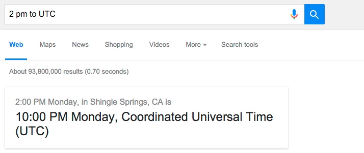
i tried like 3 and they are cumbersome but then i tried just putting the time in Google and it worked as a pop up answer. The only problem i have is i'm not sure now if i am eastern standard time or eastern daylight time now ( i always get them confused :)

so i'm in Connecticut and i want a plane i saw at 2 pm so i typed "2pm est to utc"

utc.PNG
 
Evidently those tracking websites are actually "Chemtrail Jet Tracking Tools" :rolleyes:

I've tried asking why Flight # such-n-such would leave a persistent trail one day, no trail another day, and then a short trail yet another day. The question fell on deaf ears. Have any of the chemtrail sites attempted to explain this? If they actually bothered to "look up" so to speak, and look at the same flight day after day (or week after week depending on how frequent the flight is), they might come to a conclusion that changes their world view.

Flightradar24 was one of the things that helped me see sense when I believed in the chemtrail hoax. There were many things that helped but it took a year. Arguing with debunkers was another!
 
This site takes atmospheric soundings at 0000hrs and 1200hrs Universal Time http://weather.uwyo.edu/upperair/sounding.html

The site does not "take" them, it just records them. Atmospheric soundings are done by lots of different stations that use weather balloons, then they share these results. There's 102 stations in the US (and around) operated by NOAA.
http://www.noaa.gov/features/02_monitoring/balloon.html

Everyday, NOAA’s National Weather Service launches weather balloons from 102 sites throughout the United States, the Caribbean and the Pacific to help with weather forecasting.

But as the saying goes, what goes up must come down, eventually.

There’s No Need to Fear… NOAA is Here
If you happen to stumble upon a large, deflated balloon tethered to a plain white box with the words “Harmless Weather Instrument,” don’t be alarmed. This device is actually an important piece of weather equipment called a radiosonde– a battery-powered instrument that is suspended below the hydrogen- or helium-filled weather balloon.

As the balloon rises through the atmosphere, radiosonde sensors measure and transmit profiles of air pressure, temperature and relative humidity from the Earth’s surface to about 20 miles high in the sky. While in flight, radiosonde sensors also obtain data for wind direction and speed.

Radiosonde data are received by a ground-tracking receiver, which processes it for transmission to weather forecasters and other data users. This information is a primary source of upper-air data for weather prediction models.
Content from External Source
 
I have another question on FL24:

Mick, In the tuturial you use 'settings>map>metatracks'. This is not visible here, in the new version of FL24.

Is there another workaround for this to achieve those multiple flightpaths? Couldn't find it.


Jan.
 
I have another question on FL24:

Mick, In the tuturial you use 'settings>map>metatracks'. This is not visible here, in the new version of FL24.

Is there another workaround for this to achieve those multiple flightpaths? Couldn't find it.


Jan.

That's an old hack I wrote for FR24 that unfortunately no longer works. I may try to revive it.
 
Thanks. I will be curious about it. It is handy for identifying contrails when more aircrafts are involved (which is very often the case, as we all know).
In PlaneFinder yet it is possible, but it is not accurate to determine the flying altitude when aircrafts are ascending/descending.


Jan.
 
Well, I was going to start a new thread to suggest using FlightRadar24 to identify planes with contrails in realtime, but I see this is already a very similar topic. Instead, I'll just post some followup questions here.

I'm interested identifying planes (with contrails) that fly by my location in realtime. I was curious if anyone had luck making these identifications as they happened -- i.e., is FlightRadar24 current enough to do such identification? I tried my hand at it this morning (no persistent contrail, but it was just a trial run), and my guess is UA3495, which appeared to be passing over my location on the map at the time of the image, and in the correct direction.
1676306862815.png
Content from External Source
UA3495_20230213_081220.jpg
It looks like it was at 34,000 feet at the time of my photo, and it was nearly directly overhead. Since the plane in this flight is an Embraer E170SE, I can see that it should be 98' 1" in length. Using trigonometry, I calculate that the plane should have an angular size of about 0.165 degrees (or 9.9 arcminutes).

To verify my guess, I used Photoshop to measure the pixel length of the plane in the image, and using the technique described here: https://www.metabunk.org/threads/ge...-the-radius-of-star-trails.12729/#post-282889.

Of course, you don't need to go through that, you can just look at the focal point, and the focal plane (the sensor), in a camera, and you'll see x=f•tan(a) arises. But it might be useful to imagine projecting an actual object, and thinking about where the /cos(a) comes in.

Also, using focal length in pixels simplifies things. A "pixel" is the physical spacing of sensor elements (or that, adjusted for the eventual image resolution)
Content from External Source
I calculated from the image an estimated angular size of 0.157 degrees (or 9.4 arcminutes), a difference of about 5.2% from the above estimate.

Another sanity check would be the general shape of the plane and perhaps even the number of contrails. I suppose it generally looks like it could match the Embraer E170SE picture in the FlightRadar24 link above, and this plane also has two engines (and hence two contrails?).
 
I'm interested identifying planes (with contrails) that fly by my location in realtime. I was curious if anyone had luck making these identifications as they happened -- i.e., is FlightRadar24 current enough to do such identification?
Yes.
Article:
Take Flightradar24 with you wherever you go with the best flight tracker app for iOS and Android. The #1 app in over 150 countries, our plane tracker app lets you follow live air traffic around the world from your mobile device. See detailed information about each flight on a moving map in real-time or just point your device at the sky to see what flights are passing overhead.
android_5.png
 
I'm interested identifying planes (with contrails) that fly by my location in realtime. I was curious if anyone had luck making these identifications as they happened -- i.e., is FlightRadar24 current enough to do such identification?

I use FlightAware myself, but it's very similar. I can look up and see planes and then look on the app and see what it is. Planes heading into Sacramento SMF from Seattle SEA or Portland PDX are low enough over me (~16,000') that I can make out the reds and purples of a Southwest flight vs a white Alaska or Skywest flight. This is confirmed on the FlightAware app.

I've even watched my wife fly over as she returned from business trips to Portland.

It looks like it was at 34,000 feet at the time of my photo, and it was nearly directly overhead. Since the plane in this flight is an Embraer E170SE, I can see that it should be 98' 1" in length. Using trigonometry, I calculate that the plane should have an angular size of about 0.165 degrees (or 9.9 arcminutes).
Another sanity check would be the general shape of the plane and perhaps even the number of contrails. I suppose it generally looks like it could match the Embraer E170SE picture in the FlightRadar24 link above, and this plane also has two engines (and hence two contrails?).

Are you doubting that what's on the app is correct? If you see a plane flying over you and the app lists a particular flight that appears to travel over you in the correct direction, why would you think your "guessing"? It would seem obvious, I think.

Here's a crazy contrail I managed to get a picture of last week:


Not visible in this shot, is that it was a 4 engine jet leaving 4 contrails. If it's civilian, that means it's one of 3 jets, a 747, and A340 or a really big A380. After taking the photo I opened FlightAware and sure enough:


Emirates Air flight 225 from Dubi DBX to San Fransisco SFO. And it's a really big A380. The app even draws it as a 4 engine jet. I think you'll find the apps are pretty accurate. Some military stuff doesn't show up.

And welcome to the forum.
 
An important limitation of many tracking services is that a number of planes, mainly military and business jets, get filtered out and aren't displayed. Even sites that don't may not show a plane if it is outside their receiver network. So although you can be almost 100% certain that a matching plane on FR24 etc is a positive identification, it doesn't necessarily follow that no match means it wasn't a plane.
 
Back
Top