Help identifying odd clouds

Gunguy45

Senior Member.
Not sure if this is the place for it...but I know there are some experts out there.

Had some very odd clouds (along with some weird weather last week) that I've never seen in the 6 yrs living here. I'm sure it had something to do with temps at different layers....but I haven't been able to find a picture close to what I saw. Sorry...no pic...I don't carry a camera around with me. I will try to post a basic drawing of what I saw.
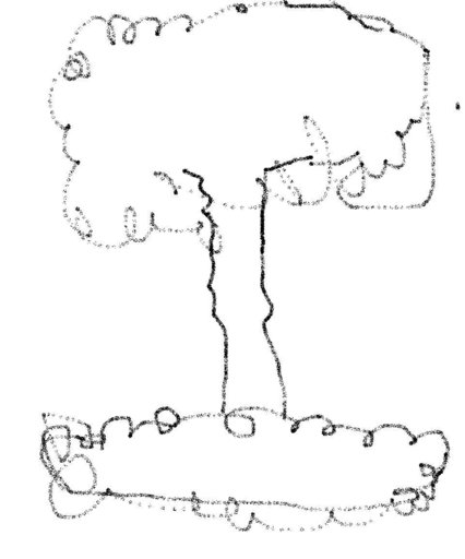
oddcloud.JPG

Yes...I know...very poor drawing. Imagine a stalk of broccoli on a puffy pita or a large pizza crust. I'd guess they were at about 10K ft at the bottom...possibly lower? I only had local mountains as a reference. No...there was no weapons testing going on....lol.

There were multiples of them in the area...maybe 10 within my view. We live in a valley at about 3300 ft with mountains from about 5000 to 7000 on both sides.

Thanks guys....
 
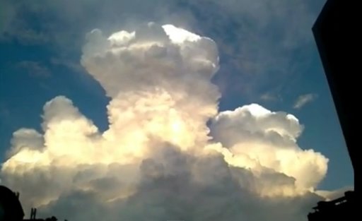
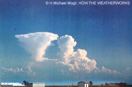
Sounds like a kind of mini towering cumulonimbus.
Ive seen something similar in the summer in Oregon.

A thermal forms a cloud when rising, then when it gets to the altitude where it stops rising it spreads out. Anvil top on a rain cloud. Mushroom on a narrow thermal cloud.
 
Thanks Mick...I tried those terms for an image...but no joy. Nothing even close.

btw...odd that this thread didn't show up after you replied when I clicked New Posts.
 
I've not seen photos like the cloud I saw either. I'm just theorising about the mechanism.

I have a few photos, but unfortunately can't get them for a week.
 
Will do, thanks. Seriously some of the strangest formations I'd ever seen. Wife is the one who said "Wow...look at the clouds".
 
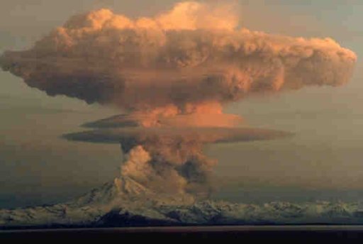
Very close TH...but the base was flatter, the mushroom was a bit flatter and wider, and the "trunk" was much taller. That's about the closest I've seen though.

Guess I need to at least carry my phone more often.
 
That looks like a version of a cumulonimbus in relatively calm air with a tight updraft column.

Something with features like these?

http://cloudappreciationsociety.org/gallery/photo-08079/

http://cloudappreciationsociety.org/gallery/photo-08000/

http://cloudappreciationsociety.org/gallery/photo-07450/

Here's what the forecast out of the NWS forecast center in Phoenix, AZ for the weather on 9/11 said:

"Numerous showers and scattered thunderstorms are expected today and tonight as a weather disturbance moves East and interacts with a very moist air mass."

Based on the drawing there probably wasn't much horizontal wind shear in your area at the time and with the aid of orographic lift that could help the clouds to develop like they did.

Someone even made a vid about "plumes" rising up near the Salton Sea, which includes a view of the sw corner of AZ.

http://www.youtube.com/watch?v=N1EldqnsUKs

Here's what Mr. Plumage himself wrote in a reply to me, even though I clearly stated convection driven CLOUDS and storms:

you're missing the plume.. not the storms man.. the actual trail coming off the ground.. you need to learn the difference.. but since you've been denying this can happen for HOW long?? its no surprise you come back with a storm that didn't hit this spot shes showing.

el oh el...
 
Thanks Solrey, the first one you linked to was close...but I think it was much larger than what I saw. Like I said...it was at least a week or so ago. I thought giant mushroom my wife said or a jellyfish.

Ahh well...I'm sure I'll see them again.
 
That kinda reminds me of the WTC collapse. No seriously I've been looking at the clouds for the last 6 months or longer thinking to myself "They don't look the same, couldn't quite pinpoint it. The other night I was driving real close to the Gulf of Mexico & said thats it. I don't recall the last time I saw nice cauliflower fluffy clouds & the ones coming right off the Gulf were but once they got over land & the further inland the unfluffier they got. I don't live too far off the coast but what I've been seeing is that the clouds looked stringy, transparent, hazy, foggy type clouds that cover a large area. I don't know if you're familiar with cloud seeding. One of the bigger cities 120 miles away is using Silver Iodide & states they put this above & below the clouds. Well I watched the video Ben Livingston Father of Weaponized Weather & he states to try to create rainfall you release this nuclei at a certain angle but if you want to dissolve the cloud you drop the nuclei from above & on the Texas site it states you can do both. I think BL is right & I think these counties using these nuclei is blowing downwind & dissolving clouds in un-participating counties. I just started taking pictures & need to accumulate some rain samples. Check out if they're any rain modification programs in your area & let me know if you've seen similar type clouds?

http://www.youtube.com/watch?v=uynthEwqizU

http://www.tdlr.state.tx.us/weather/weatherfaq.htm
 
Oh did the cloud produce rain or did it just seem to kinda dissentigrate into a transparent cotton candy type cloud?
 
Ben Livingston saying that "Weather modification exists" and the US used rain making in Vietnam is as controversial as apple pie.

It is the seed of truth upon which he hangs his other theories for which he never seems to manage to provide any actual evidence, such as his ideas that hurricanes can be steered - supposedly a 1974 report says so - but he doesn't' actually link to it anywhere hat I have found.

There really was a program that tried to modify hurricanes, and at first they thought they did affect hurricane strength (not direction). However, subsequent data and analysis found that the changes could be accounted for by natural causes, and in fact the whole working hypothesis of the idea was falsified - they found that hurricanes actually have very little supercooled moisture, so seeding would have no effect. See Project Stormfury:

Data and observations began to accumulate that debunked Stormfury's working hypothesis. Beginning with Hurricanes Anita and David, flights by Hurricane Hunter aircraft encountered events similar to what happened in "successfully" seeded storms.[26] Anita itself had a weak example of a concentric eyewall cycle, and David a more dramatic one.[25] In August 1980, Hurricane Allen passed through the Atlantic, Caribbean, and Gulf of Mexico. It also underwent changes in the diameter of its eye and developed multiple eyewalls. All this was consistent with the behavior that would have been expected of Allen had it been seeded. Thus, what Stormfury was accomplishing by seeding was also happening on its own.[27]

Other observations in Hurricanes Anita, David, Frederic, and Allen[28] also discovered that tropical cyclones have very little supercooled water and a great deal of ice crystals.[29] The reason that tropical cyclones have little supercooled water is that the updrafts within such a system are too weak to prevent water from either falling as rain or freezing.[30] As cloud seeding needed supercooled water to function, the lack of supercooled water meant that seeding would have no effect.

Those observations called the basis for Project Stormfury into question. In the middle of 1983, Stormfury was finally canceled after the hypothesis guiding its efforts was invalidated.[31]
Content from External Source
 
It is noctilucent season. On May 24th I noted after sunset that it looked like the sky was electric blue and sure enough at a latitude much further north they were photographed that evening. The sky is a more beautiful hue here when the Sun is 5-15% below the horizon on certain evenings. I have not seen the actual clouds here yet (34 parallel)

see; http://www.spaceweather.com/
image.jpg
Awesome animation;
http://spaceweather.com/gallery/indiv_upload.php?upload_id=82871

Mt. Redoubt
image.jpg
From http://geology.com/stories/13/spectacular-volcanic-eruptions/redoubt-eruption-cloud-lg.jpg
 
Back
Top