As well its path appears to be a straight line when the footage is stabilized to the ocean:
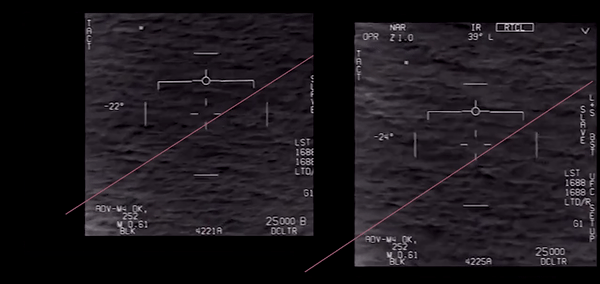
And what you see there is mostly NOT the object moving. It's the parallax from the camera approximately tracking the ocean, and the motion of the jet.

As well its path appears to be a straight line when the footage is stabilized to the ocean:
GF_jet_MAX_30kt-180dg.txt
Forgive me if I'm being obtuse.
This is a reasonable calculation of the distance and direction of the jet from the beginning of the video to the end based on the on-screen data?
First of all, the document you link to is an older generation ATFLIR, the NITE-Hawk. Instead of doubling the FOV from 1.5 to 3.0, you may need to cut it in half to 0.7.
When I finally made what I consider to be a close approximation to the video in Blender the parallax looks closest with a fov of 0.7
And what you see there is mostly NOT the object moving. It's the parallax from the camera approximately tracking the ocean, and the motion of the jet.
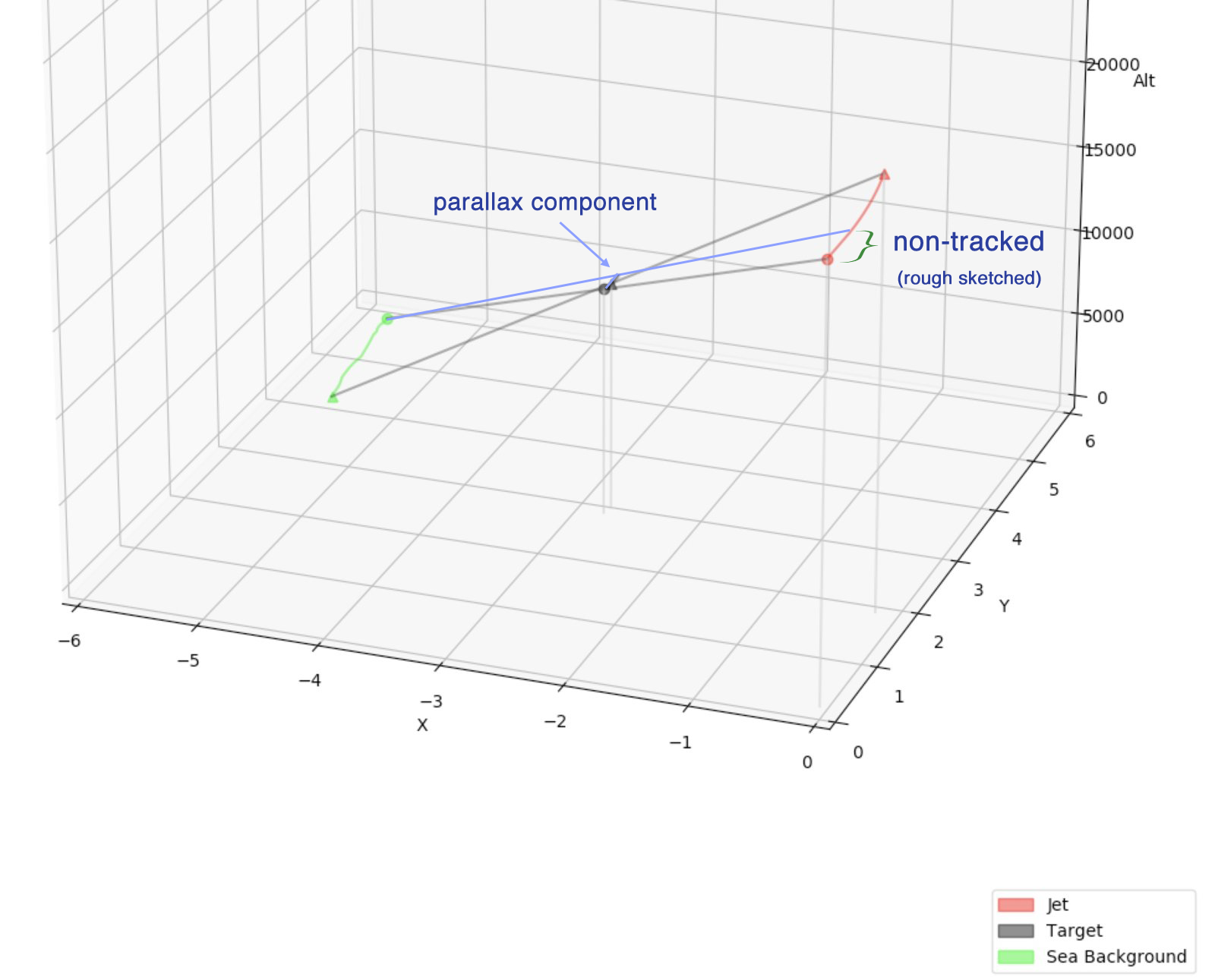
Ought not the non-tracked segments produce a difference in the graphing, something roughly like this?
That's what happening, as far as I can tell. It's ground tracking based on the jet's speed and position. Then the pilot is presumably adjusting the camera to acquire the target.I'm not sure if the camera does some sort of auto ground tracking and then a person manually adjusts it 'ahead' of the object.
I wonder why Gimbal is named so appropriately and Go Fast so inappropriately. Has TTSA or Elizondo ever explained how they were named?
I don't know why exactly and who precisely dubbed this footage "go fast" since "slow mover" would have been more adapted for this specific piece of footage. Maybe TTSA has nothing to do with this choice, maybe they do, we can only speculate for now but I think it was not a wise choice. I also think that people who are in direct contact with TTSA should ask them.
Despite it being neither high speed nor low altitude, and not demonstrably an "aircraft".External Quote:GO FAST is an authentic DoD video that captures the high-speed flight of an unidentified aircraft at low altitude
Neither of which are correct when your target is far enough away to be a dot. A moot point anyway, as the size of the object is <10 feet.External Quote:
- There are no obvious wings or tails on the object. Even IR imagery of a cruise missile, would have visible wings at this range.
- There is no exhaust plume from the object. An exhaust plume is clearly visible on conventional aircraft in the mid-wave infrared frequency used by the ATFLIR.
Despite it being neither high speed nor low altitude, and not demonstrably an "aircraft".
Neither of which are correct when your target is far enough away to be a dot. A moot point anyway, as the size of the object is <10 feet.External Quote:
- There are no obvious wings or tails on the object. Even IR imagery of a cruise missile, would have visible wings at this range.
- There is no exhaust plume from the object. An exhaust plume is clearly visible on conventional aircraft in the mid-wave infrared frequency used by the ATFLIR.
Size estimates. The video frame is 950 pixels across in the Washington Post version. When the object is closest (3.3 nautical miles), the object appears around 12 pixels across. Hard to say exactly. But from these numbers we can calculate the angle subtended by the object as as 12/950*1.5 degrees)
tan(12/950*1.5 degrees)*3.3 nautical miles in feet =6.6 feet
View attachment 32200
Arguably you could say it's larger, but I think if anything it's smaller, as it's very blurry.
So what birds have a 6 foot wingspan, and can fly at 13,000 feet?
(or what other object, like weather balloons).
TTSA indicates that Gimbal was the name of the file they received from the DoD. As they state on their Gimbal-video page:I wonder why Gimbal is named so appropriately and Go Fast so inappropriately. Has TTSA or Elizondo ever explained how they were named?
@ http://archive.is/Q9wh0External Quote:The filename "GIMBAL" seems to be traceable to the unusual maneuvering of the UAP.
Yes, lol, that was also our conclusion, the appearance of an anomalous aircraft is a product of the ATFLIR.External Quote:GIMBAL is a product of one of the most sophisticated tracking systems on US military aircraft.
Its 6-10 feet big if that, cold, moving slowly and at 13000 feet, as far as we can tell it is as zoomed in as that military spec IR camera can do.
So they're saying they didn't name it as they themselves are attempting to interpret the name. In contrast, their errant claims that the Go Fast object goes fast implies that they gave it that name.
Lol! I wouldn't be surprised. And here's another oddity. Why would Elizondo's team be speculating on why the file was named 'Gimbal' if it was something his ATIP program studied? It's as if the footage is from another department entirely, like maybe a department associated with teaching pilots about confounding screen targets.Especially odd to use a different naming convention for segments from the same video. If Go Fast was named by TTSA, then perhaps the Pentagon named it Balloon or Parallax.
I saw that you guys, specially Mick, worked really hard on what I call the SAI (Situation Awareness Indicator), that little white square seen in both "Gimbal" and "Go Fast" ATFLIR interfaces. I came to the same conclusion about "Gimbal", it cannot be displaying the azimuth of the IR camera so chances are it is displaying "True North".
It gets more complicated with "Go Fast" since the SAI seems to behave differently and to be honest, I need to work more on this issue before coming to a provisional conclusion.
Not sure if this is helpful or entirely useless...
I'm not sure why you say this, as they seem to behave consistently to me. It appears to be the heading and tilt angle of the target relative to the jet.


Sure, let met explain, it's not related to how it "behaves" but to its position on the interface.
It's very hard to find informations on the SAI (Situational Awareness Indicator), also called SAC ("C" as Cue) in other flight manuals (Combat sim). The only informations I found about it comes from simulators (Flight Manuals). I only uploaded one screen capture of such a manual, there's more but they all say the same thing.
View attachment 32488
When I insert a disc on the "Go Fast" footage, the Azimuth angle is not that much off (1°) but my disc might not be accurately positioned. Now comes my problem, the elevation angle is way off (-9° instead of -22°).
View attachment 32489
This is what happens when I superimpose "Gimbal" and "Go Fast" when respectively, Az is 48°L in both cases and El is -2° for "Gimbal" and -28° for "Go Fast". It looks like I have an "ok" match for "Gimbal" (point A if the SAI is not displaying true north) but again, it's way off when it comes to El angle for "Go Fast" (point B). I added a yellow point B to show where the SAI should be from my understanding and if the center of the interface represents -90° (straight below the aircraft)
View attachment 32490
I hope you guys understood why I am going through some head-scratching.
But can we extract useful information from that?
The "radius" angle is related to the aircraft bank angle. If I overlay the bank angle on the above graph:
View attachment 32304
We can see the where the bank angle is slowly decreasing towards the end, the indicator angle is decreasing - presumably because the object is getting closer.
One could subtract the two, with care. Exercise for the reader!")
Not sure if this is helpful or entirely useless...
It would be killer if you scanned it or something and uploaded it somewhere and shared the URL here so we all could see it. Thanks in advance.
no. its publicly available information.Do they send you stuff only if you first vow that you'll only ever talk about what they send you, but you're otherwise forbidden to ever show anybody else what they send you? Or some deal like that?
...you have to request they send it to you...
")
you are asking him to scan the letter he received? or any responsive documents he may receive from his request?Either that, or we just have to take @Andrew Saturn's word for it, I guess
External Quote:All offices searched produced ZERO results and I was given another "no records response" by a key agency mentioned by Mr. Elizondo. http://www.theblackvault.com/casefi...nge-and-the-secret-dod-ufo-research-program/#
AATIP was a DIA Program. New York Times verified this, themselves, via records obtained. https://www.nytimes.com/2017/12/16/us/politics/pentagon-program-ufo-harry-reid.htmlyou are asking him to scan the letter he received? or any responsive documents he may receive from his request?
The Black Vault guy scans his stuff and so far he concurs with @Andrew Saturn. this letter received March 28, 2018:View attachment 32555External Quote:All offices searched produced ZERO results and I was given another "no records response" by a key agency mentioned by Mr. Elizondo. http://www.theblackvault.com/casefi...nge-and-the-secret-dod-ufo-research-program/#
External Quote:In response to questions from The Times, Pentagon officials this month acknowledged the existence of the program, which began as part of the Defense Intelligence Agency. Officials insisted that the effort had ended after five years, in 2012
New Summary Video, somewhat simplified and incorporating some bits from episode 4 of "Unidentified" on the history channel.
Source: https://www.youtube.com/watch?v=PLyEO0jNt6M