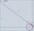
Gimbal - 3D analysis

TheCholla

Active Member
I'm starting a new thread to share results from my 3D model for Gimbal, now that I have more objective and accurate results. Please disregard my previous thread when I say I thought the clouds were much closer, I put too much interpretation in visuals when Geogebra 3D does not seem be accurate in that regards for things that are very far apart. I hope @Mick West can delete my previous thread.

The model

First, what is in my 3D model. It's quite simple, I reconstruct the plane trajectory, building from what we learnt in that thread :
https://www.metabunk.org/threads/gi...ates-using-lines-of-bearing-and-or-dcs.11836/

I reconstruct the F18 trajectory using 4 radius circle to follow the changes in bank angles during the video. PT1 is for mark 0'01, PT2 is mark 0'11, PT3 is 0'21, PT4 is 0'31, and PT5 is 0'34. The corresponding azimuths of the objects at each point are 52°, 38°, 20°, -2° and -7°. I use smoothed azimuth angles provided in the thread mentioned above. Here is the trajectory, in the 3D model and in the 2D model I had made before.
Screenshot from 2022-02-28 12-40-25.png Screenshot from 2022-02-28 12-46-27.png

This trajectory and azimuth angles give pretty smooth lines of sight (LoS), and the question is whether the object was an UAP before the LoS intersection, or a distant plane after the LoS intersection.

In the 3D model I reconstruct the LoS in 3D using the elevation angle, that we know is in between -2.5° and -1.5°. The cloud cover is represented by a sphere, that moves with the F18 to account for the F18 displacement and curvature of Earth. The cloud cover height can be adjusted, it increases the sphere radius to mimic change in cloud height.

Screenshot from 2022-02-28 12-49-15.png

What it says on the clouds

What I do first is to find at which height the clouds need to be to be in the FOV of the pod, for elevation angles -1.5° to -2.5°. In fact I went a bit lower/higher than that to trace the curve below (-0.7 to -2.8) and see things with more perspective.

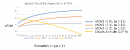
For a given elevation angle, the cloud height is adjusted to be right in the FOV intersection (I use a FOV of 0.35° and 0.35°cones around my LoS). Then in each configuration I can check how the clouds are "scanned" by the camera from PT1 to PT4. From one LoS to the other, I count the number of FOV scanned by the camera laterally. This is to compare to the lateral cloud motion we see in the video. That's what I was trying to do visually in my other thread, which does not work because the software does not respect the dimensions when zoomed so much. Now I count the number of FOV scanned from PT1 to PT2 (nFOV1), PT2 to PT3 (nFOV2), PT3 to PT4 (nFOV3), objectively by measuring the lateral (orthogonal) distance between the LoS, and translates it in number of FOV.

I've made a plot to show the different nFOV in function of the elevation angle, as well as the corresponding cloud height.

1646082112319.png
My estimate of the number of FOV scanned in the video is this : NFOV1=3.5 ; nFOV2=2.5; NFOV1=1.5. I consider the FOV length as being the diagonal of the screen, it seems to match better with the numbers of my model. I think it's in agreement with data from this thread : https://www.metabunk.org/threads/automated-motion-tracking-in-videos-like-gimbal-and-gofast.12299/ , if we consider how the clouds traverse the diagonal, not width, of the screen. This is open to discussion though.

In the graph above, we see that before the LoS intersection, i.e. for a cloud height of 20500' and above, the modelled nFOV do not match the video. They are too low.
For the max elevation angle of -2.5°, the cloud height needs to be at least 5000ft to be in the FOV (the true horizon is at -2.8°at 25000ft).
The nFOV numbers from the model start being in good agreement with the video from elevation angle -1.8°, or a cloud height of ~15000 ft.
From this, I estimate that the cloud height must be between 5000ft and 15000ft. It's not a huge refinement but at least it's something.

Now, there is atmospheric refraction at play, and by following numbers mentioned in another thread, the Earth+cloud sphere should be 7/6 times bigger to account for it. Accounting for this, all the numbers above are switched up by 0.2°, so that my optimum interval for the cloud cover height would be 2500ft-13000ft. But atmospheric refraction depends on a lot of things so it's not a sure estimate, just something to keep in mind as far as uncertainties.

In summary the results suggest mid-level clouds. If I had to guess, I would bet on nimbostratus : "The main body of Nimbostratus almost invariably occurs at altitudes between 2 km and 4 km (6 500 ft and 13 000 ft) in polar regions, between 2 km and 7 km (6 500 ft and 23 000 ft) in temperate regions and between 2 km and 8 km (6 500 ft and 25 000 ft) in tropical regions."
Here is an example,they look close to what we see in the video. Could be stratocumulus too, but they are lower and would be on the lower bound of possible cloud height.

1646082947776.png

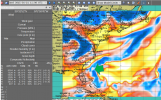
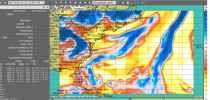
Now this is a wild guess, but looking at the meterological data I shared here : https://www.metabunk.org/threads/me...standing-gimbal-january-20-and-21-2015.12145/
this would match the cloud system that was off Jacksonville, on Jan 21 2015, 11 UTC

1646083055987.png

Pretty much exactly ~300 miles of Jacksonville, with a wind of 115 Knots around the altitude of the jet (not shown here), and mid-level clouds in the area. But this is just guessing.

About the distant plane trajectory

This is only derived from the 3D LoS, the conclusions are about the same for all elevation angles from -1.5° to -2.5°.

Screenshot from 2022-02-28 13-28-18.png

At ~30 NM, the intersections of the LoS with the horizontal give a straight trajectory (shown above), which would be consistent with a plane flying away (at 20200ft for -1.5°elevation, 17000 ft for -2.5°).

I agree this is a strange coincidence, that the LoS are consistent with this. However I find that they are only kinda consistent, because I don't get equal intervals between the plane positions corresponding to PT1 to PT5 of the F18. The intersection points (Plane1 to Plane5) are more distant to each other at the end than at the beginning. Between PT1 and PT2, the speed I get is ~220 Knots, while the speed at the end is ~380Knots. This is an unrealistic acceleration.

Now the values are very sensitive to small changes in the F18 position, so it may be possible to tweak the values to get a constant speed trajectory (I checked, small tweaks in the elevation angle don't do it). The F18 trajectory was really refined to match data from the other thread, so changing it is just guessing at this point. But I will try and see if can retrieve a straight and non-accelerated trajectory with only small changes in the F18 position.

Here it is for a more accurate description of what I see in this 3D reconstruction. I wanted to check by myself what's going on, maybe it will be helpful to others.

Model is here, but not really user-friendly, sorry :
https://www.geogebra.org/3d/azzryzhx
 

Attachments

  • 1646084034841.png
    1646084034841.png
    650.8 KB · Views: 158
  • 1646083018350.png
    1646083018350.png
    1.4 MB · Views: 164
  • 1646082044938.png
    1646082044938.png
    56.4 KB · Views: 187
  • Screenshot from 2022-02-28 12-45-07.png
    Screenshot from 2022-02-28 12-45-07.png
    73.4 KB · Views: 155
Last edited:
This is only derived from the 3D LoS, the conclusions are about the same for all elevation angles from -1.5° to -2.5°.

Screenshot from 2022-02-28 13-28-18.png

At ~30 NM, the intersections of the LoS with the horizontal give a straight trajectory (shown above), which would be consistent with a plane flying away (at 20200ft for -1.5°elevation, 17000 ft for -2.5°).
A doubt. If that represented region is beyond the pivot point, why do you say the plane is moving away? LOS should be temporarily progressive from right to left. Correct?
 
Regardless, any object positioned beyond the pivot points, to be tracked that way by the POD, must move in the opposite direction of the fighter. Therefore, if it is true that the fighters have spotted it while they were returning towards the aircraft carrier from the training areas, it means that they were moving from east to west. Therefore the uap in this condition was flying from west to east, that is, it was not traveling against the wind.
 
You're correct @Leonardo Cuellar , the trajectory above is seen from below. Here it is from above, right to left, as expected.
Screenshot from 2022-03-01 08-53-41.png

As far as your second remark, both an UAP before the LOS and a plane after the LoS could go to the west, against the wind. We don't know exactly in which direction the F18 was flying. I remember in R. Graves interview he says they were a squadron of F18 on their way back to the carrier, and one of the F18 made a detour to go check out a radar return, and captured Gimbal. We don't know in which exact direction the F18 was flying.
 

Attachments

  • Screenshot from 2022-03-01 08-55-57.png
    Screenshot from 2022-03-01 08-55-57.png
    181.9 KB · Views: 158
Last edited:
Here is the trajectory that keeps the horizon in the FOV at 10 NM, from above (left), and from the horizontal (right). G1 to G5 are points of the trajectory at 0'01, 0'11, 0'21, 0'31, 0'34. Like @Edward Current , I retrieve that the object would have to climb, reverse direction, in a weird U shape.
UAP1.png UAP2.png
 
Regardless, any object positioned beyond the pivot points, to be tracked that way by the POD, must move in the opposite direction of the fighter. Therefore, if it is true that the fighters have spotted it while they were returning towards the aircraft carrier from the training areas, it means that they were moving from east to west. Therefore the uap in this condition was flying from west to east, that is, it was not traveling against the wind.
The object(s) displayed on the SA page were much closer, inside 10 NM and therefore inside the "LOS intersection point." (Minor quibble, there is no LOS intersection point. By my analysis, the slowest that anything can go while remaining in the sightline is about 75 knots.) If my hypothesis is correct that the "fleet" is actually a glitchy misrepresentation of a more distant object, they'd be headed in opposite directions to the actual object, and curiously enough, possibly turning straight around as Graves reported.
 
As far as your second remark, both an UAP before the LOS and a plane after the LoS could go to the west, against the wind. We don't know exactly in which direction the F18 was flying. I remember in R. Graves interview he says they were a squadron of F18 on their way back to the carrier, and one of the F18 made a detour to go check out a radar return, and captured Gimbal. We don't know in which exact direction the F18 was flying.
I bring you the testimony of Ryan Graves that you yourself quoted in the Thread on meteorology in Gimbal:

“On that particular day, the day the Gimbal was filmed, we were involved in a large air-to-air mission. You’ve got anywhere from 10 to 12 jets in the air wing going off to an area to do a mission. Then you’ve got a group of aircraft overhead the boat acting as the aerial refuelers. When my buddy took that video, he was heading back to the ship, and then here goes this thing like 40 miles away from the boat. It’s not in the data link. All the radars are reporting it, but it’s nothing popping up identifying what type of aircraft it is or whether it’s friend or foe. Then you’ve also got the five or six other objects in the wedge formation. We were like 300 miles out off the coast. It’s hard for me to imagine it was just another jet in the system.”

This instead is extracted from Graves' video for the AIAA:

"While returning from an Air-to-Air training mission, another A/C in my flight observed a number of interesting radar contacts. While stern converting the object and within 10nm, we see the following (GIMBAL object, ed).

There's no mention of a maneuver that would have involved the pilot changing course again after he was heading for the aircraft carrier.
 
@Leonardo Cuellar , changing course or not to intercept Gimbal, we don't know in which direction the F18 was flying. Coming back to the carrier does not mean going west. The carrier could have been north of where they did their air-to-air mission. So we cannot know with certainty the wind direction during the encounter, do you agree ?
 
@Leonardo Cuellar , changing course or not to intercept Gimbal, we don't know in which direction the F18 was flying. Coming back to the carrier does not mean going west. The carrier could have been north of where they did their air-to-air mission. So we cannot know with certainty the wind direction during the encounter, do you agree ?
In reality the wind is the only thing we know for sure.
So starting from that data, and from the substantial assertion that the object was going against the wind, we should reconstruct the trajectory of the fighter, and therefore where the aircraft carrier was positioned and therefore where the object itself was positioned.
However one element emerges from our analyzes. That on the days indicated of the alleged accident, i.e. January 20 and 21, 2015, there is no trace at any time of a 120kt to 25000ft wind in the affected area. And even if a fairly strong wind appears (90kt which in any case are not 120kt), this is present in an area where there are no clouds attributable to those in the video.
 
@Leonardo Cuellar , where do you get this data from ? Remember the data I discuss is hourly wind average, so with 90Knots in average you may very well have wind gusts at 120 Knots. Jan 21, morning UTC, is the time when there were strong westerly winds in the 120 Knots range off Jacksonville. Maybe a bit higher than the plane elevation, but it's a pretty good match. I invite you to check the IR brightness images of Jan 21, you'll see there were clouds off Jacksonville around that time :
https://climatereanalyzer.org/wx/satellite/

Has anybody tried to reconstruct the LoS in 3D ? It's fairly easy to do, especially between two points that have a constant banking angle, because the plane trajectory can be traced along a circle.

For example, between marks 0'03 and 0'08, the plane has constant banking, angle of 27°, which corresponds to 1.545° of turn rate. Using smoothed azimuth angles (from frame to frame analyses), the two points correspond to ~49.7° and ~42.7° Azimuth.

If we trace the corresponding LoS in 3D, for an elevation angle of -1.6°here, it gives this points of intersection (plane1, Plane2) for the LoS, 30Nm from the F18. The distance between the intersection points corresponds to a speed of ~250 Knots.

0'03 to 0'08.png

Between 0'10 and 0'18, he plane has constant banking angle of 32°, which corresponds to 1.895° of turn rate. Smoothed azimuth angles are ~39.5° and ~26° Azimuth. The plane speed is 355 Knots, ~100 Knots more.

0'10 to 0'18.png

This is for an elevation angle of -1.6°, but it applies to all elevation angles between -1.5° and -2.5°. The speeds can be reconciled by tweaking the elevation angles, but the horizon does not seem to move much in the FOV during these two short time frames. Would be good to see similar calculations made by others, and check if results align.
 
I'm really tired of the constant hostility in the comments, so I'll leave it there. Discussion is impossible. What about your analyses, are they free of any error ? Can you retrieve the exact object and F18 trajectories with a 0.01°/s precision by estimating them from the cloud motion?
 
I'm really tired of the constant hostility in the comments, so I'll leave it there. Discussion is impossible. What about your analyses, are they free of any error ? Can you retrieve the exact object and F18 trajectories with a 0.01°/s precision by estimating them from the cloud motion?
It's more frustration than hostility. I'm sure my analysis is full of error. Anyone's analysis will be. It's a question of the width of that error window to a particular degree of uncertainty. I would argue that mine is relatively narrow compared to the various other attempts here on Metabunk, because I've quantitatively demonstrated that translational uncertainties are dwarfed by angular uncertainties in this case. Everyone else has derived an F-18 flight path from the bank angle, which frankly is craziness because of the distances involved (even within 10 NM). The tiniest error in that second-to-second angle of the ATFLIR, if other analyses could put a camera on their sightline, would result in significantly wrong cloud motion. That means significantly erroneous conclusions, if you're trying to determine whether or not the object in a particular scenario is banking slightly for example.

I'm certainly biased, but I think it's a much more accurate approach to derive the camera angles from the cloud motion. The sharpness of the angular information that they provide is amazing. I don't know why you pooh-pooh the cloud motion. You can pull angular information almost to single-frame accuracy. Compare that to the onscreen ATFLIR angle or calibrated airspeed numbers, which only update five times per second, yet which people consider sacrosanct. Data doesn't have to be a number projected onto a screen. The clouds represent fine-grained data; the numbers do not, and the bank-angle-to-turn-rate calculation is wildly uncertain, yet critical.

Can you retrieve the exact object and F18 trajectories with a 0.01°/s precision by estimating them from the cloud motion?
Not the object trajectories obviously, because the best we can do is find the family of its trajectory solutions. The F-18's trajectory? That actually doesn't matter so much, because its position in space at any moment is a translational quantity. The rotation of the camera is much more critical, and yes, from the cloud motion one can certainly get the latter to within 0.01°/s averaged over the length of the video, which is 34.25 seconds and therefore almost a whole .35° FOV (.03425°). Over the course of the whole video, the uncertainty is relatively small (the uncertainties wash out, they don't progressively accumulate like in other analyses).
 
Last edited:
...The cloud cover is represented by a sphere, that moves with the F18...

To me (somebody who is not an expert on nephology) modeling clouds as a sphere seems incongruous with the mechanisms by which clouds move in reality. 1​

Can you elaborate on why you consider your representation of clouds as a sphere in geometry software, to be an ideal way to prove your theory?

...From this, I estimate that the cloud height must be between 5000ft and 15000ft...

Is it fair to assume that you arrived at that estimate based on your model of the clouds as a sphere?


...the question is whether the object was an UAP before the LoS intersection, or a distant plane after the LoS intersection..

So having now done some rigorous analysis, what is your answer to that question?

1Why a sphere?


Source: https://youtu.be/qxsHLAIrMQE

Content from External Source
 
Earth is a sphere, therefore a uniform cloud layer surrounding Earth is a slightly larger hollow sphere.
 
Those are cumulonimbus clouds. The clouds in the originally video are on larger scales "flat" (tops at a constant altitude, plus or minus their particular small-scale relief). With a spherical earth, that makes the upper surfaces generally spherical across a scale of miles.
 
Earth is a sphere, therefore a uniform cloud layer surrounding Earth is a slightly larger hollow sphere.

One of the things that makes it seem incongruent to me, is that "uniformity".

Modeling clouds as a sphere, if you increase or decrease the height of the clouds at the location of the Gimbal video's F18 and "flying saucer", wouldn't you also decrease and increase the clouds by the exact same amount everywhere across the planet?

I get why, in general, a sphere might be used as an artistic rendition of global cloud cover.

Depicting clouds as a sphere is something that I wouldn't be surprised to see done in maybe Blender or After Effects or something like that.

I'm not convinced that mathematically modeling clouds as a single geometric object of a globally uniform volume and surface area, is an intended application of GeoGebra. But then, I've never used it myself. So I have to defer to others who have.

Hopefully, @TheCholla won't mind answering my question himself and explaining why he is convinced that it is.
 
One of the things that makes it seem incongruent to me, is that "uniformity".
Throughout the 34-second clip, the cloud tops are parallel to the horizon indicator.

Screen Shot 2022-03-04 at 9.26.11 PM.png

So, we actually have evidence of its uniformity on larger scales, which means it is necessarily spherical.

Modeling clouds as a sphere, if you increase or decrease the height of the clouds at the location of the Gimbal video's F18 and "flying saucer", wouldn't you also decrease and increase the clouds by the exact same amount everywhere across the planet?
No, the particular cloud layer in the video (presumably) doesn't cover the entire planet. For modeling purposes all it needs to be is a piece of a shell large enough to be cover the sightline:

Screen Shot 2022-02-24 at 3.46.40 PM.png
 
Modeling clouds as a sphere, if you increase or decrease the height of the clouds at the location of the Gimbal video's F18 and "flying saucer", wouldn't you also decrease and increase the clouds by the exact same amount everywhere across the planet?
Yes, but the rest of the planet isn't the part of the model that concerns us, so it doesn't matter.
What matters are the clouds we see, and if their tops are at approximately 15000 ft, those tops approximate a segment of a sphere with radius of (Earth+15000). How else would you model them?
Hopefully, @TheCholla won't mind answering my question himself and explaining why he is convinced that it is.
Are you asking your question to learn the answer, or to pick a fight?
 
...Are you asking your question to learn the answer...

I asked because I presumed that posters here are following (at least in spirit) something sorta like the scientific method.

I therefore also presumed that, as a "peer" struggling to understand another "scientist's" premise or some part of their methodology, it wouldn't be unreasonable to ask the original "scientist" to elaborate on their premise and/or methodology.

...How else would you model them?...

Me personally? I wouldn't.

One reason I wouldn't is I'm cool with conceding that, "I don't know". Which, correct me if I'm wrong, is a position the scientific method is cool with too.

I'm also cool with people whose jam is rigorously sweating the details. Somebody's gotta do it. But that's not my jam.

Big picture reality is my jam. When something seems incongruous with big picture reality to me, then I feel compelled to ask questions.

...to pick a fight?...

Why would you interpret those ?s at the end of all my earlier sentences as code for, "Fight me IRL, bro"? In reality, ?s are code for "I'm asking because I don't know".

So, here they are again for @TheCholla's convenience:

...

Can you elaborate on why you consider your representation of clouds as a sphere in geometry software, to be an ideal way to prove your theory?

...From this, I estimate that the cloud height must be between 5000ft and 15000ft...

Is it fair to assume that you arrived at that estimate based on your model of the clouds as a sphere?


...the question is whether the object was an UAP before the LoS intersection, or a distant plane after the LoS intersection..

So having now done some rigorous analysis, what is your answer to that question?
 
it wouldn't be unreasonable to ask the original "scientist" to elaborate on their premise and/or methodology.
Scientists base their work on the work of others. "Standing on the shoulders of giants" and all that.

See, Edward Current put a curved cloud layer in his simulation, after I mentioned it on his thread, and now TheCholla has it in his. Who is the "original scientist", and why does it matter?

One reason I wouldn't is I'm cool with conceding that, "I don't know". Which, correct me if I'm wrong, is a position the scientific method is cool with too.
Yes, but then you won't understand much. A lot of choices only become understandable if you get at the issues from a "how do I do this" perspective. Once you ask the questions that way, even if you can't answer them, you'll understand the answers better that you're given.

When something seems incongruous with big picture reality to me, then I feel compelled to ask questions.
Yes. And this looks exactly like you're picking issues to start a fight over, and making it personal fits that impression. If that's not your intent, I recommend you stop doing it.
 
...Edward Current put a curved cloud layer in his simlation...

See...

...Depicting clouds as a sphere is something that I wouldn't be surprised to see done in maybe Blender or After Effects or something like that.

Presuming @Edward Current's simulation was not done in GeoGebra; which is the "geometry software" my original question to @TheCholla was referring to.

...this looks exactly like you're picking issues to start a fight over...

But, of course, this doesn't:1​

...Are you asking your question ... to pick a fight?...


If it does, then...

...I recommend you stop doing it...


1​ Guess what? It does!
 
Last edited:
Presuming @Edward Current's simulation was not done in GeoGebra; which is the "geometry software" my original question to @TheCholla was referring to.
Geogebra is a 3D program, and modeling this incident is a 3D geometry problem, complex and dynamic though it may be. Why wouldn't a sphere be used to model the upper surface of the clouds in Geogebra or any other 3D program?

But then, I've never used it myself. So I have to defer to others who have.
Now might be a good time to do that.
 
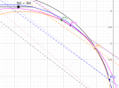
FYI, here is the trajectory of the F-18 in my Geogebra reconstructions, overlaid with the one from Edward Current. Mine is shown by points 1 to 5, Edward's trajectory is the yellow curve. They are very very close.

Eddie_trajectory-overlay.png
 
To put an end to my analysis of Gimbal, here is how a close trajectory looks like in my model, within a 10 Nm range. In this example the object starts at 10Nm, and ends up at 7.5 Nm.
Close trajectory.pngScreenshot from 2022-03-17 09-54-19.png

G1 to G5 are positions of the object at 1/10/21/31/34s, respectively. Speed goes from 170, to 120, to 27, to 40Knots, between each interval. So it almost comes a stop, do a "vertical U-turn", and starts going in the opposite direction. This matches what Ryan Graves says about the event.
Maybe there was a glitch in the system, that made a distant plane trajectory appears like this in the F-18 instruments. But this is far-fetched and just speculation as long as we do not get more data. And yes, such a trajectory is crazy and far-fetched in its own way, but if the range R. Graves gives us is correct, this is it.

When it starts at 10 Nm, the object gets closer by ~25%, which is consistent with the object getting bigger on the screen. Like I said in my original post, I find that these lines of sight also correspond to a straight and leveled trajectory at 30Nm, consistent with Edward Current. But unlike him, I do not find a steady trajectory for a plane at 30Nm, as the plane would need to accelerate substantially from PT1 to PT5. I do not know the cause for the difference in our results here. Our F-18 trajectories are very close (post just above), I use smoothed azimuth angles provided by markus, and I constrain the LoS elevation so that the cloud horizon stays in the field of view (the clouds are represented by spheres in my model, i.e. flat cloud cover hypothesis).

I've written more about what I think of the distant plane theory on Reddit :

Source: https://www.reddit.com/r/UFOs/comments/tewtpw/for_the_gimbal_ufo_to_be_a_plane_it_needs_to_be/?utm_source=share&utm_medium=web2x&context=3


This was more for me to sum up my thoughts, don't take it as if I'm trying to convince anybody. You guys think it's a distant plane, or the Atlas rocket, all good.
 
@sitarzan , yes I don't care, my name is Yannick Peings, you can easily find what I do if you google me. I work in science, not really related to this though, so I'm not an expert at all. Just doing a little geometry on my free time, like many here.
And I really don't give a damn about reddit "karma". I thought that was an important message to share because I spent time into this, it only represents my view.
Well Done!
People know a little bit of folks like West, Lehto, Graves, Elizondo, Mellon, etc's backgrounds.
Well I would say at this point that it would be more appropriate to ask these folks some scientific expertise similar to our friend Yannick ... Or No?
 
...ask these folks some scientific expertise similar to our friend Yannick ...

Sorry. I'm struggling to understand that bolded part of your sentence. Apologies if I'm not reading you right.

Are you proposing that the people I named should develop better expertise at some particular scientific discipline?

From what I know of West (and what I understand "the scientific method" to mean), in my opinion his methods could be described as scientific; even though he doesn't bill himself as a card-carrying, practicing scientist.

Lehto I know the least about. I just know he's a Navy veteran that used to fly fighter jets. I've seen only the one video with him and West.

A Top Gun, he may be. From what I remember of that one video though, Lehto's math chops came across as rusty.

From what I've watched/read of Mellon and Elizondo, I've filed their contributions away in the pseudoscience folder of my mind. 'Nuff said?

You've contributed a decent amount of stuff in a bunch of threads. What is your expertise, if you don't mind my curiosity?
 
Lehto I know the least about. I just know he's a Navy veteran that used to fly fighter jets. I've seen only the one video with him and West.
Lehto said some things that are blatantly untrue about optics in one of his first videos. And he said those things with the utmost confidence. Unless he has made another video apologizing and amending his previous videos, I wouldn't give any credibility to anything he says.
 
... What is your expertise, if you don't mind my curiosity?"...

Preemptively volunteering this for the sake of fairness:

I haven't contributed here in the active ways that others have.

I come here mainly to learn; to ask questions.

Back when I first joined this forum, I did share a sliver of detail about my ex-military background.

I considered that specific moment of my work history to be relevant to the particular topic of that one thread I was commenting in three, four years ago.

For whatever it's worth: I write computer programs for a living these days. For banks, government agencies, corporates, start-ups, whatnot.

My hobby1 is also computer programming related.

So since I'm not contributing hypotheses nor theories about anything I'm expert at, I see anything about either my educational or professional background as being irrelevant.


1​ I use the term loosely​
 
Sorry. I'm struggling to understand that bolded part of your sentence. Apologies if I'm not reading you right.

Are you proposing that the people I named should develop better expertise at some particular scientific discipline?

From what I know of West (and what I understand "the scientific method" to mean), in my opinion his methods could be described as scientific; even though he doesn't bill himself as a card-carrying, practicing scientist.

Lehto I know the least about. I just know he's a Navy veteran that used to fly fighter jets. I've seen only the one video with him and West.

A Top Gun, he may be. From what I remember of that one video though, Lehto's math chops came across as rusty.

From what I've watched/read of Mellon and Elizondo, I've filed their contributions away in the pseudoscience folder of my mind. 'Nuff said?

You've contributed a decent amount of stuff in a bunch of threads. What is your expertise, if you don't mind my curiosity?
I apologize. Mine is an outburst against the principle of authority.
 
Back
Top