
creatonez
New Member
Because the rotation of the Earth forces mass near the equator against gravity, the Earth is a shape known as an oblate spheroid, a shape mathematically equivalent to taking a sphere and scaling it down on one axis.

Many things in science and engineering have to take into account the true shape of the Earth, called the reference ellipsoid. Most notable is GPS, which uses the WGS standard for determining correct coordinates on a slightly squashed Earth. Modern land surveying and computer GIS systems would be crushed if assumptions about the oblate spheroid shape of the Earth were wrong. (They would be even more crushed if it turns out the Earth is flat.)
Anyways, I saw a comment on a flat earth debunking video asking why you can't see the oblateness of the earth in photos of the earth. I was curious so I grabbed an image from the Himawari 8 satellite, rotated the right hemisphere 90 degrees and transposed it on the bottom of the image such that it matches up with the equator.
The oblateness is a very small effect, but can be seen clearly in these high resolution images:

Here is a less compressed version of the above image https://cloudflare-ipfs.com/ipfs/QmegMQSwmDS6X7aHXH3r832uS86zFbTjy1ABYQfd3BjmwG (12 MiB instead of 5 MiB)
It seems Metabunk automatically cached and recompressed my extremely large image

If you want to do this yourself, go to https://seg-web.nict.go.jp/wsdb_osndisk/shareDirDownload/bDw2maKV?lang=en and look for full-disk images with a timestamp close to 11:32 JST, which is when the sun is directly between the geostationary satellite (positioned at 140.7° E) and the Earth, so the shown hemisphere is completely lit up. The images are centered exactly on the earth, so you can make the cut at 5500 pixels on either axis. Interesting aside... because of the pitch black pixels during the night, the PNG-compressed image size fluctuates wildly over a 24 hr period.
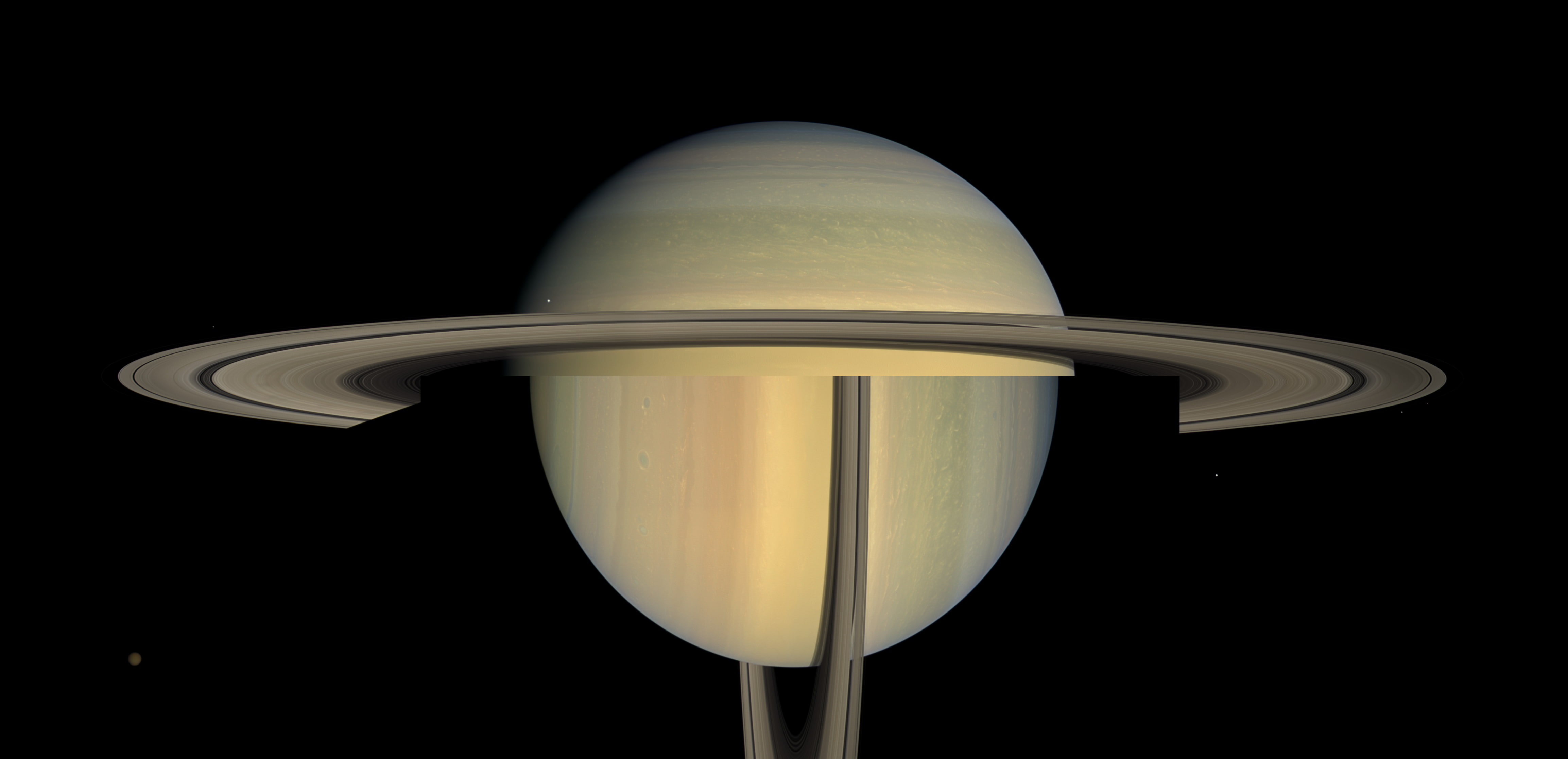
The most oblate planet in the solar system is Saturn, with a polar diameter of around 90.203% the equatorial diameter. We can do the same thing to photographs of Saturn and see a much more pronounced oblateness.
Many things in science and engineering have to take into account the true shape of the Earth, called the reference ellipsoid. Most notable is GPS, which uses the WGS standard for determining correct coordinates on a slightly squashed Earth. Modern land surveying and computer GIS systems would be crushed if assumptions about the oblate spheroid shape of the Earth were wrong. (They would be even more crushed if it turns out the Earth is flat.)
Anyways, I saw a comment on a flat earth debunking video asking why you can't see the oblateness of the earth in photos of the earth. I was curious so I grabbed an image from the Himawari 8 satellite, rotated the right hemisphere 90 degrees and transposed it on the bottom of the image such that it matches up with the equator.
The oblateness is a very small effect, but can be seen clearly in these high resolution images:
Here is a less compressed version of the above image https://cloudflare-ipfs.com/ipfs/QmegMQSwmDS6X7aHXH3r832uS86zFbTjy1ABYQfd3BjmwG (12 MiB instead of 5 MiB)
It seems Metabunk automatically cached and recompressed my extremely large image
If you want to do this yourself, go to https://seg-web.nict.go.jp/wsdb_osndisk/shareDirDownload/bDw2maKV?lang=en and look for full-disk images with a timestamp close to 11:32 JST, which is when the sun is directly between the geostationary satellite (positioned at 140.7° E) and the Earth, so the shown hemisphere is completely lit up. The images are centered exactly on the earth, so you can make the cut at 5500 pixels on either axis. Interesting aside... because of the pitch black pixels during the night, the PNG-compressed image size fluctuates wildly over a 24 hr period.
The most oblate planet in the solar system is Saturn, with a polar diameter of around 90.203% the equatorial diameter. We can do the same thing to photographs of Saturn and see a much more pronounced oblateness.
Last edited by a moderator:
")