Debunked: Plumes erupt from New Madrid Seismic Zone =2.9M quake follows. more coming?

scombrid

Senior Member.
3/5/2012 -- ENTIRE SOUTH and MIDWEST ! Steaming Plume event = be alert and aware http://www.youtube.com/watch?v=sAczH7O8J_Y&feature=channel

3/1/2012 -- Plumes erupt from New Madrid Seismic Zone = 2.9M quake follows.. more coming?
http://www.youtube.com/watch?v=dEMR2BSgBwg&feature=related

The youtube video seems to think that plumes on visible satellite on otherwise clear and dry days are steam coming from the ground, perhaps extinct volcanos being rejuvenated by fracking or perhaps an impending geological event.

He says this:
The chances of "wildfires" all erupting AT THE SAME TIME over multiple states.. would either mean a network of arsonists, or a fairly well timed wildfire EACH DAY .. which then magically goes out overnight and half the day.. and then at sunset fires up again. Also, the chances of "control burns" all at the same time across multiple states .. again are minimal...

I personally think this is the sign of an imminent geologic event of larger proportions.


Actually it is quite likley that it is "control burns" all at the same time across multiple states. Land managers follow a pretty specific set of guidelines for prescribed fire. They seek specific atmospheric and fuel conditions for fire, dry but not too dry. That means that when people have prescribed burns planned it is highly likely that they end up burning at the same time if weather is right over a large area as in the sprawling dry high pressure in the 5-March video.

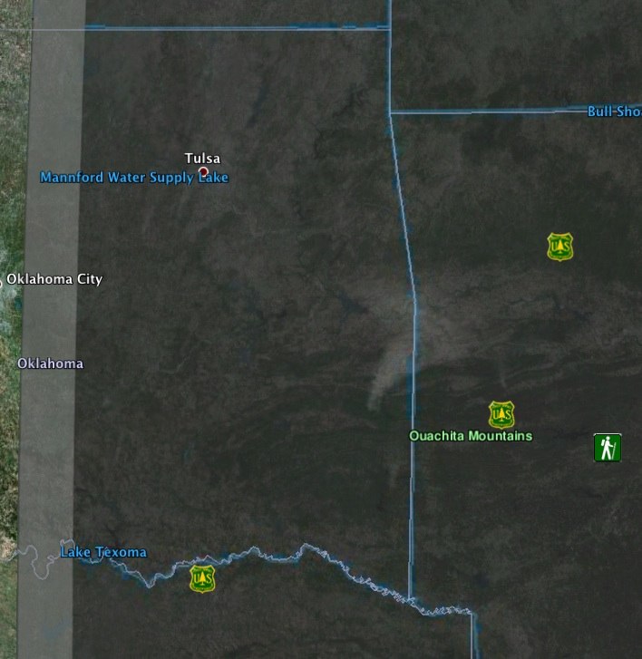
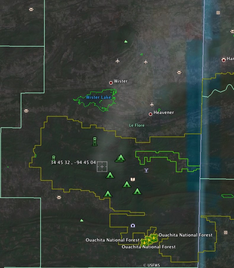
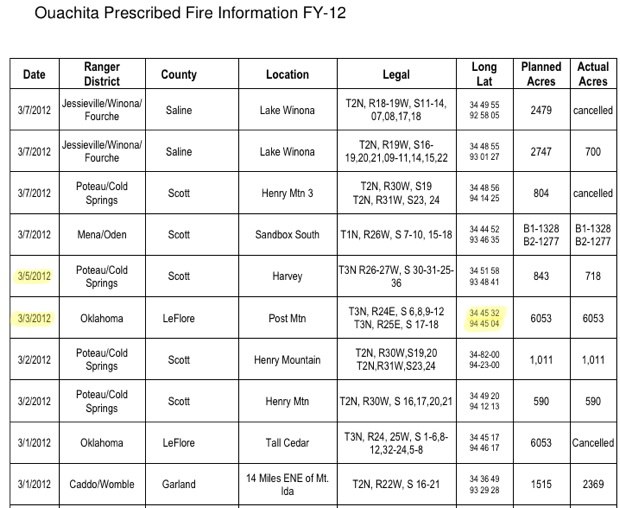
Most of the plumes in Arkansas, Missouri, and Oklahoma are prescribed fire in the Ouachita and Ozark-St. Francis National Forests.

https://fs.usda.gov/Internet/FSE_DOCUMENTS/stelprdb5334735.pdf
http://www.fs.usda.gov/Internet/FSE_DOCUMENTS/stelprdb5351120.pdf

The fires listed match the locations of the plumes in the 3/1 and several of Dutchsinse's other videos. Other smaller fires are likely farmers, state land managers and such also taking advantage of the weather to conduct planned burns.

Regarding the fires occurring at roughly the same time over a wide geographic area. Burns are most effective when relative humidity is below 35% and transport winds and dispersion indices are suitable to clear the smoke. However, fire managers want to avoid uncontrollable fire so they will not seek to burn when relative humidities will remain below the critical point into the night or wind winds are severe. The ideal condition will be such that dewpoints are relatively low and relative humidities of 25-35% are realized during the warmest portion of the day but that temperature will fall off and relative humidities rise in the evening thus damping the fire once the planned burn is accomplished. The result is that fires are lit during the morning and reak peak size and intensity in the early to mid afternoon during the time of maximum diurnal temperature and minimum relative humidity. This is also the time of day when mixing of the lower atmosphere is maximize and transport/dispersal of the smoke is maximized. This is why the smoke plumes in Dutch's videos all appear at around 1700UTC and persist till but start to die down just before it gets dark at around 2230 to 2300. The diurnal synchronization of the plumes that Dutch insists makes it impossible for the plumes to be fire smoke are one of the very things that indicate that the plumes are indeed simply smoke.

Uncontrolled wildfires are even prone to this sort of diurnal fluctuation. We see it in Florida all the time during our fire season. Thermal inversion at night will cause surface winds to decouple from the gradient winds and become calm. The relative humidity at the surface will then approach saturation. The fire will die back and smolder and cause really dense smog. Then the sun comes up, heat the lower atmosphere and mixes out the inversion, gradient winds and dry air mix down to the surface with relative humidity dropping from fog to 20% in about 4 hours and POOF the fire flares up and starts jumping fire breaks.

I found the burn plans from the USFS corresponding to a lot of Dutch's "volcano" plumes. I don't see any reason to research any of the other plumes when they have every characteristic of smoke on visible satellite.
 
Area forecast discussions from a couple of NWS offices on the day of the 5-March video:

AFD from Jackson MS NWS office from Monday morning:
.FIRE WEATHER...CONDITIONS WILL BE A BIT BETTER FOR PRESCRIBED
BURNING TODAY COMPARED TO YESTERDAY. A COLD FRONT WILL MOVE THROUGH
THE REGION THIS MORNING BRINGING IN NORTHERLY WINDS. SURFACE AND LOW
LEVEL WINDS WILL DECREASE ... THIS WILL BE
DUE TO THE UPPER TROUGH PULLING FARTHER AWAY FROM THE REGION AND
HIGH PRESSURE BUILDING IN .. RH VALUES WILL BE A LITTLE
BETTER TODAY WITH MINIMUM HUMIDITY FROM AROUND 25 TO 35 PERCENT.


Monday AM AFD from Springfield MO NWS:
.FIRE WEATHER...
AN ELEVATED FIRE CONCERN WILL DEVELOP AGAIN LATE TODAY AS THE
SURFACE GRADIENT BEGINS TO TIGHTEN AROUND SUNDOWN. HOWEVER...THIS
MORNING AND INTO THIS AFTERNOON LOOKS TO BE POTENTIALLY
GOOD FOR PRESCRIBED BURNS. IF THAT OCCURS HOWEVER...FIRES COULD
BECOME DANGEROUS ONCE WINDS BEGIN TO INCREASE LATE IN THE DAY.
 
And now this:

http://gacc.nifc.gov/sacc/predictive/intelligence/SACCMorningReport.pdf


This is from the Geographic Areas Coordination Centers, National Interagency Fire Center.

Dutchsinse says that it is impossible that "multiple hundreds of fires" started at the same time on Monday but NIFC says:

3/5/2012 – 3/6/2012
Prescribed Fire Activity:
State and Federal lands – 281 prescribed fires for 43,592 acres burned in AL, AR, FL, GA, KY, LA, MS, NC, SC, TX.
 
How did i know this was Dutchsince, before I even got to the video

Of course it was dutch. Today he's claiming that ground clutter in PA caused by a strong thermal inversion was really HAARP Scalar Radar being used to cause severe weather in the area within the next three days (apparently he's now into Tom Bearden). I'm wondering if there's any use in addressing his weather vids. His subscribers are very loyal. Even with the prescribed fire reports from multiple land management agencies, federal and state forest services, handed to them they still insist that fire is impossible as an explanation for the "plumes" on visible satellite. Several are today claiming that the plumes caused the rain that is impacting MS, AR, OK area. Apparently he makes a living off of his vids as he obviously has more time to make video after video than I have time to debunk his myriad of mistakes.

I am kind of suprised that he doesn't get more play here since he covers such a broad range of "theories" with chemtrails and HAARP being merged into one big weather manipulation conspiracy.
 
I've never really followed what Dutchsinse does. Seems like he was mostly focussed on the radar rings.

He can't be making that much money from his videos. Youtube pays about $1 to $2 per 1,000 views.

Hmm, although he has 1,107 videos!!! Still, if he gets 10,000 views on each one, that's only around $10,000. And he does not see to have enabled ads on any of the ones I saw.

So maybe he's just an enthusiastic true-believer?
 
Unfortunately you haven’t sold me on the idea that these are controlled burns. I searched all the locations listed for OK. and none of them were in the location of the largest plume in the beginning of the video.

Do you have any idea as to why what appears to be the largest "fire plume" isn’t reported on the link you posted?

Using google earth the area appears to be a geological active in/ around Pushmataha county

Thanks for your input.

Did you find a single person that reported volcanic activity?
 
Unfortunately you haven’t sold me on the idea that these are controlled burns. I searched all the locations listed for OK. and none of them were in the location of the largest plume in the beginning of the video.

Do you have any idea as to why what appears to be the largest "fire plume" isn’t reported on the link you posted?

Using google earth the area appears to be a geological active in/ around Pushmataha county

Thanks for your input.

I did the most accurate overlay I could in Google Earth:


Zooming in, the base of the plume is in the Ouachita National Forest, in Le Flore County.


There was a prescribed burn on 3/5/12, but the location of this one matches the 3/3/12 burn closer
https://fs.usda.gov/Internet/FSE_DOCUMENTS/stelprdb5334735.pdf

 
Last edited:
Mick...you are a rockstar debunkah. :cool:

The burn on 3/3 was 6053 acres. That would make a respectable plume of smoke seen from a satellite.

Dutch just sits there at his computer all day smokin' blunts and makin' stuff up about things he sees on satellite, radar and earthquake reports, none of which he understands and what little he does understand is just manipulated to his advantage while counting on the stupidity of his viewers. He cobbles half truths and fantasy together with a few technical terms any 8th grader should know and his cult-like followers eat it up like he's some kind of highly educated expert or something. He's no more than a hustler, a grifter...sowing fear and ignorance among his viewers who probably toss him enough coin so he doesn't have to get a real job.
 
Do you have any idea as to why what appears to be the largest "fire plume" isn’t reported on the link you posted?

The Post Mountain burn on 3 March is the big plume. See Mick's post.

Thanks for the illustration Mick. I guess I should know that only supplying the pdfs without visual aid is insufficient.

Dutch is within day trip distance of this area. He drove up to a nuclear power plant to do some kind of investigation. Why doesn't he drive down to this area and see if those burns really are burns?

As for geological activity. Why would it have a diurnal signal? We expect prescribed fire to behave like that, with fires deliberately set in the morning under specific conditions with the intent that the fire will peak in the afternoon and peter out as the sun sets, winds back down, and relative humidity increases. What geological process would generate a diurnal signal?
 
"Former Weather Man Scott Stevens" of the website and youtube channel "weatherwars" chimed in:

These are fires, "plane" and simple. Chemtrails drift, mostly, with the winds. There is a single point source which means that these have to be ground based sources of smoke.
Dutch has NO training in anything meteorological. I like his enthusiasm, but every single video I've had forwarded to me that have been deep flaws in his interpretation of the imagery! Every single one, so I just don't spend anytime watching his stuff.

Guess dutch is stepping on Scott's turf.
 
He blocked me for my comments here.

http://www.youtube.com/watch?v=eThull6ESC0&feature=channel


All I did was explain ground clutter and Intellicast's method for trying to filter non-precipitation returns from radar mosaics. So he deleted the comments, made a statement that I didn't know what I was talking about, and then blocked me from responding.

Some of the comments are advocating violence against "HAARP facilities". I hope they don't start pestering NWS offices.

Oh, and for some all in one bunk.

"Want to know about Chemtrails, HAARP , VLF, UHF and weather modification? Want to prove it to a non-believer? Here you go!"

http://sincedutch.wordpress.com/201...nt-to-prove-it-to-a-non-believer-here-you-go/

This one is worthy of a debunk thread but I flat do not have the time to cover even a fraction of what he has dumped in this post.
 
Here is his post after deleting me:

""this is no hoax.. they USED to accuse me of photoshopping RADAR until they realized the links were below.. they have NO clue about conjugate point magnetism or efficiency scaling.. I mean.. scrombrid for one.. all this person would have to do is go read the HAARP VLF buoy project data.. then they would see that indeed signals DO bounce back and forth for days.. or they could watch a bit on Scalar RADAR.. lol.. when they fail at half baked science, then they resort to name calling""

I did not accuse him of a hoax or call him names. I did point out that NEXRAD signals are not VLF and do not bounce around for days. I then explained how NEXRAD works and in what frequencies. What did I do wrong?

Oh, and his "Scalar Radar" refers to a video featuring "Tom Bearden".
http://www.youtube.com/watch?v=qogOs28uW3c
http://www.youtube.com/watch?v=bPR1N9fMKeU

I'm done. I've been through two youtube accounts trying to counteract Dutch and I'm not wasting time on a third.

General question. Why are you accused of being a paid disinfo shill with a lack of video production on your channel being evidence of your shill status? Wouldn't a paid shill have a slick channel with a the bells and whistles and lots of videos?
 
I've never really followed what Dutchsinse does. Seems like he was mostly focussed on the radar rings.

He can't be making that much money from his videos. Youtube pays about $1 to $2 per 1,000 views.

Hmm, although he has 1,107 videos!!! Still, if he gets 10,000 views on each one, that's only around $10,000. And he does not see to have enabled ads on any of the ones I saw.

So maybe he's just an enthusiastic true-believer?

Today's stats:
46,840 subscribers
22,922,271 video views.

Having ads disabled is part of his gimmick. He says that's because he's doing this as a public service.

When I start to think he is an enthusiastic true-believer with a bad case of confirmation bias regarding his "HAARP rings and scalar squares and resultant weather, he turns around and puts out videos like his fire plumes where he could easily drive an hour or two and confirm his satellite "observations" of steam coming out of extinct volcanoes, but he does not. After being shown prescribed fire plans and reports by multiple agencies he continued to produce videos on the topic and never corrected himself. Then fire management and fire behavior were explained to him. He just moved on. Seems as soon as there's a bit of heat he starts blocking and deleting.

46,000 subscribers seems a hearty number for the genera. He's got more subscribers than JREF channel (16,000) or the Rational Response Squad (38,000) (though both have more subscribers and video views than I expected). Scott Stevens' WeatherWars channel only has 717 so Dutch seems to be winning in the Chemtrail/HAARP/WeatherMod conspiracy game on youtube.
 
On his Facebook page:

http://www.facebook.com/dutchsinse

He has this:


Which goes to this video:
http://www.youtube.com/watch?v=xk1-f1fewWA&feature=share

Which is by a guy (Dallas Goldbug) whose entire MO seems to be finding people on TV that look superficially similar, and then saying they are the same person, hence everything on TV is faked, so the Illuminati is real. Example: he says these two guys are the same guy - a "tame" guy they trust to do fake news stories.


Pro debunking tip - when comparing faces, first compare the ears. (Not that it's particularly necessary here, as it's obviously different guys, but it's a quick way to fid a major difference)

He goes on to say ridiculous things like the Gabrielle Giffords shooting was faked.

I makes me wonder if he has some kind of disorder like a mild form of face blindness (apparently around 2.5% to 10% of the population does, to some degree) but does not realize it, and is just identifying people based on certain macro characteristics.
 
Last edited:
On his Facebook page:

http://www.facebook.com/dutchsinse

He has this:


Which goes to this video:
http://www.youtube.com/watch?v=xk1-f1fewWA&feature=share

Which is by a guy (Dallas Goldbug) whose entire MO seems to be finding people on TV that look superficially similar, and then saying they are the same person, hence everything on TV is faked, so the Illuminati is real. Example: he says these two guys are the same guy - a "tame" guy they trust to do fake news stories.


Pro debunking tip - when comparing faces, first compare the ears. (Not that it's particularly necessary here, as it's obviously different guys, but it's a quick way to fid a major difference)

He goes on to say ridiculous things like the Gabrielle Giffords shooting was faked.

I makes me wonder if he has some kind of disorder like a mild form of face blindness (apparently around 2.5% to 10% of the population does, to some degree) but does not realize it, and is just identifying people based on certain macro characteristics.


I did not get past the images before I noticed that the 'ginger' would have needed an ear transplant.

Obviously I agreed before agreeing...?
 
Last edited by a moderator:
Some folks might be catching on to the scam. The following comment of mine became the top rated comment in less than 20 minutes.

http://youtu.be/eFT08lAWxvw

Looking at the storm reports for 3/12: 0 tornado, 7 wind and 5 hail = HAARP Forecast FAIL!

If the weather was being controlled with haarp et al. as dutch claims, then ham radio operators would be chattering about anomalous propagation, interference and unexplained signals etc...but they're not. Go to any ham radio forum and see for yourselves, maybe even join and ask the radio experts about haarp and weather. Search term = "ham radio forum"


Storm Prediction Center has accurate forecasts

Question is...how long will it take him to delete that commment and/or block me...again. :rolleyes:
 
Check out this "forecast" from his Facebook:

"""check out southwest Kansas -- Dodge City... time to get out of dodge!!! nexrad FLARING into high RF -- massive haarp ring unlike any other that ive seen before.. this one "phases" in and out.. VERY HIGH RF .. maxing out in the "white" .. watch kansas for 24 to 48 hours from NOW 508 am CST 3/12/2012.. heres the link"""

What a joke. Weather has been clear clear and clear there since his "forecast". And check out his make-believe sciencey terms.
 
He's disabled the comments on all the plume videos and the recent weather videos except this most recent weather video.
 
He's disabled the comments on all the plume videos and the recent weather videos except this most recent weather video.

Yep, he's a cowardly hustler...go figure.

I'm looking at the 2-day convective outlook. I'll bet radar anomalies (haarp rings) will happen within the next 24-48 hours associated with the approach of the system that hit the west coast yesterday and dutch will put up a video warning of severe weather "within 24-48 hours" from a "haarp ring outbreak" across a swath of states including TX, OK, KS, MO, IL, IN and MI. However there should be no more than some heavy rains with very few reports of hail or strong winds due to limited convective potential.

So, as a truly free service...that's my prediction for where haarp rings will be seen within 24-48 hours and the weather that will follow. :cool:

cheers
 
Question is...how long will it take him to delete that commment and/or block me...again.

he actually replied to your comment...in typical fashion of course.

And in typical fashion he finally deleted my comment, deleted his reply and blocked me, all within 11 hours...he must be slackin' and distractin' today. :p

cheers
 
Is he a liar or suffering from confirmation bias? Here is one of his latest comments:

""""but i didn't "poke around long enough" .. I saw a flash on RADAR with that small town like red cloud, rayne, or hopkinsville.. thats all I used / saw.. and called it.. am I just "lucky"?its not a "trick".. you can watch for a Flash ring/haarp ring.. then watch the town for 2-3 days.. its simple really..
don't consult ANY other source either.. just use the rings and get back to me after you see one appear.. and wait for 2-3 days.. should be some appearing any time now ..""""

1. He claims a successful prediction even when the weather does occur at the center of the ring.
2. He claims success when there isn't actually any severe weather. He'll point at moderate returns and claim they are severe (it helps him when TITAN on intellicast screws up).
3. He never acknowledges the frequent times when he makes a prediction and the weather is spectacular for days afterward.
4. He's gotten to the point where he will cast a net of "prediction" that covers 1/3 of the country in advance of an approaching storm system and as long as weather occurs somewhere in that massive area he'll claim "success" and his subscribers think he's helping them but providing "accurate" forecasts.
 
Here's a copy of dutchtweekins reply to my comment:

@timsolrey where are the storm prediction centers youtube video warnings 2-3 days before hand.. looking for those.... oh yes.. they don't exist and are very inaccurate.. they don't name towns thats for sure.. they name ENTIRE REGIONS.. like "the south" or "midwest".... you think that is accurate?

as for HAM radio.. you should search the term "haarp scalar radar"... and learn a thing or two

There was a second reply that I didn't notice until I checked email this morning:

@timsolrey IDIOT.. what is it like to be a stupid brainwashed POS NWS cronie? how does it feel to have BLOOD ON YOUR HANDS? you're supporting MURDERERS at this point..

scombrid asked if he was a liar or suffering from confirmation bias. I'd say both, and at this point I'm also convinced he's a Tweeker

He fits the profile... paranoid, dishonest, beligerant, prone to nonsensical rantings, can't hold a real job and always begging for money. Stays up for several days in a row... big clue right there. (there must be hundreds of comments asking if he ever sleeps on the one hand, while on the other hand there are nearly as many comments asking where he's been)

I've noticed a pattern in the timing of when his videos are made and uploaded. The videos, even his comments, often come in batches over the course of three or four days occuring at all hours of the day and night, the times when his followers ask if he ever sleeps. Then the flury of videos is followed by no vids or dutch comments for two or three days and his followers ask where he's at 'cause he missed a bunch of stuff he normally would make vids for. The pattern repeats itself with another batch of vids and comments followed by crickets. His blog appears to pretty much follow the same pattern. He also lives right in the heart of tweekerland.

http://www.connectmidmissouri.com/news/story.aspx?id=722695

just use the rings and get back to me after you see one appear.. and wait for 2-3 days.. should be some appearing any time now.

Two ways he would know there "should be some appearing any time now". He uses the official forecasts to anticipate radar action so he can be staring at Intellicast at the right times in order to record the anomalies he knows are likely to happen with the atmospheric conditions associated with approaching weather systems...or dutchtweekins is reading this thread.

If his subs want to blindly follow a charlatan like that...well, sorry 'bout their luck.
 
He made another plume vid today and of course has blocked all of my accounts and deleted from all his previous plume vids any evidence that the plumes were smoke, primarily from controlled burns.

http://www.youtube.com/watch?v=oEIpOc7DBLY&feature=channel

3/14/2012 -- Midwest Volcanic Plumes -- story making the rounds = next Mega-quake coming?!

A few of the comments in page 1 of comments:

""""Sighs..... plumes coming out of the ground in such a wide area all at the same time, to me is an obvious precursor (potentially) for some type of land mass anomaly. It seems so obvious for anyone who payed any attention in 8th Grade Science. I thought it when you spoke of California, and thought it recently in your video of the same in the lower midwest. I appreciate your insights, and alert intellect.""""

She must have been a crackerjack in school if she thinks that smoke on visible satellite is volcanic in nature.

"""""
Why do they go off at once? Why at sunset? I have seen the question, but no answer."""""

Dutch deleted my answer(s). The answer is in two parts. First part. They go off all at once because weather conditions dictate when forresters conduct burns. Under ideal conditions minimum relative humidity is reached between 1 and 3 pm then rises as the sun sets and temperatures cool. That means that prescribed burns will typically be set to peak in the early to mid afternoon which corresponds to the 1900 UTC time stamp on the visible satellite images that Dutch is using. The second part is that they clearly aren't happening at sunset. They appear at 1900UTC and are visible until 2200-2300UTC. If they happened at sunset they would never be visible on visible satellite.

Dutch was handed the burn plans complete with times and coordinate of planned and executed fires. He lives in the region in question and could easily have ground truthed his "theory". Yet he did not ground truth and he soldiers on with this fiction. He is definitely a liar.
 
He explicitly states in this video that "Critics said that they were controlled burns. But we went and verified that and they weren't all controlled burns..."

He also continues to insist that they "all appear at sunset" even though it was pointed out to him that 1900UTC is not sunset in Missouri and Arkansas.

He says that they can't be fires because "they erupted at the same time every night and were gone by morning". What a lying sack of shit. The fires were not at night and controlled burns are meant to lay down as the sun sets. He knows this. He deleted all comments stating such.

I really don't want to create yet another youtube account but this latest video is just over the top. It is completely fraudulent.
 
Everything about that guy is fraudulent.

Here is the article that's "making the rounds", posted on Before It's News. Yeah, making the rounds of all the way out conspiracy junkie sites.

The article and dutch's video's are just total BS in every way. The locations and timing of the controlled burns matching the "plumes" seen on satellite are right there for all to see. Dutch is just seriously misinformed or out right lying (probably the latter) about vulcanism in the region. Indeed, there are no dormant volcanoes in Arkansas, just a couple of extinct volcanic pipes. The prior vulcanism in that region is long extinct. Does he not know the difference between active, dormant and extinct vulcanism? He mentions Hot Springs, AR as proof of volcanic activity but those hot springs are not of volcanic origin.

http://www.hot.springs.national-park.com/info.htm#hot

But in this area, the earth is relatively quiet. There is no evidence of magma lying close below the earth's surface to heat underground water. Instead geologists believe that just the right combination of rock types and old faults exists here to permit water to perculate deep, where it is heated by surrounding rock.

In an arc from the northwest around to the east, outcroppings of Bigfork Chert and Arkansas Novaculite absorb rainfall. The pores and fractures in the rocks conduct the water deep into the Earth. As the water percolates downward, the increasingly warmer rock heats it, and filters out the impurities. In the process the water dissolves minerals in the rocks. Eventually the water meets the faults and joints in the Hot Springs Sandstone leading up to the lower west side of Hot Springs Mountain where it flows to the surface.

He's got a couple new weather vids where he's lying about successfully "predicting" "severe weather", which amounted to a few isolated thunderstorms producing hail in a part of the nearly 1/4 of the country "predicted" to receive "extreme weather":

Jackson, Kentucky — Wilmington, Ohio … eastwards towards Washington DC — even as far south as Jacksonville Florida — be aware of possible tornadoes in the next 24-48 hours (these towns specifically may get the worst parts of the coming TWO STORMS).

HAARP rings appearing in conjunction with Scalar Squares — usually the outcome is extreme weather in these frequency manipulated areas:

In the description of this video he claims success for the aforementioned "prediction":

Severe weather is beginning to break out in the HAARP ring / Scalar Square effected areas from 2-3 days ago.

Here is my post with screenshots on the subject from 3 days ago.. warning these areas for severe weather, hail, damaging winds, and possible tornadoes: Link HERE

He's exaggerating. There were a handful of isolated storms that produced some hail, whoopee, but nothing close to what would be considered severe or extreme. http://www.spc.noaa.gov/climo/reports/120314_rpts.html

Today will probably be similar or even less stormy.

His followers comments actually shed some light into the mentality of people who get sucked into cults like Jonestown and Heaven's Gate. Wow, I suppose in a way his stuff is educational afterall.
 
the "haarp rings"?

are they really just the shape left by the sweep of the radar?
surely it couldn't be that obvious, how could anyone be that deliberately stupid?
anyone got a picture of what they mean by that?
 
the "haarp rings"?

are they really just the shape left by the sweep of the radar?
surely it couldn't be that obvious, how could anyone be that deliberately stupid?
anyone got a picture of what they mean by that?

What they call "haarp rings" is pretty much any of a number of radar anomalies that are actually well known to those familiar with weather radar. Here's a good introduction to a variety of radar anomalies and a history of the so-called "nexrad hoax", of which dutch is pretty much just an unwitting, or not, copycat.

http://www.letxa.com/anomalyintro.php

The edges of individual coverage areas are sometimes visible on national composite maps where those circular coverage areas overlap and they also call those "haarp rings". I explain what that is, with labeled screencaps HERE.

The nexrad radars don't display the real time "sweep" like older radar systems. What you see on a nexrad display is a "snapshot" of either a composite of all scan elevations (composite reflectivity) or a specific individual scan elevation (like "base" reflectivity which is the lowest scan angle) after a completed full scan/scans are processed . A more thorough explanation HERE.

cheers
 
Many of these claims could be debunked easily by making a telephone call to a store or city hall in the neighborhood. Claims of volcanoes erupting visible from space will be widely known in any area by everyone. This is not something that can be covered up.
 
Many of these claims could be debunked easily by making a telephone call to a store or city hall in the neighborhood. Claims of volcanoes erupting visible from space will be widely known in any area by everyone. This is not something that can be covered up.

He is impervious to debunking. Attempted debunking is just evidence that "they" are out to get him because he is telling the Real Truth(tm). The lack of any eye-witness reports is just further evidence of a cover-up. Someone asked of him yesterday where was the news coverage and suggested that the people that live in that area have the answers for Dutch. Dutch's reply?

news coverage on something that might hurt spending investment and local economies?? have you ever seen the movie Dante's Peak? lol.. j/k.. but seriously.. news does not cover these things..


He lives within easy day trip of the Ozarks and Ouachita where most of the burns in his latest videos were conducted. He could easily have gone to the sites himself, hiked up, and seen if it was fire or volcano.

That he was supplied the burn reports from more than one forrestry agency that all conducted burns on the days that Dutch was reporting plumes should have been enough to end this particular fantasy. Those reports included dates, acres burned, and Lat/Lon of the burns. Biggest burns happen to be right on his "volcanoes" when you pop the lat/lon into google earth. That the smoke plumes all appear between 12 and 3pm should rule out geological activity as this is consistent with fire behavior but geologic phenomena whould have no reason to have a diurnal signal like this. But he ignores and/or deletes all such information and continues to take donations from his subs.
 
Scombrid,
about all you can do is an individual effort to create reponsive debunking videos, and maybe ally with others who are in opposition, I have seen them somewhere on youtube
No matter what you do, some will be willingly duped. That's just the way it is.
 
Here's the latest "plume" video and blog post, this time it's in New Mexico:

New Mexico dormant volcano VENTING STEAM--Carrizozo lavid fields

Volcano plume erupts from New Mexico DORMANT volcano

For sure it is NOT a fire (pictures show DIRT and DESERT)..

That idiot seems to think the desert of New Mexico is just nothing but dirt or something. He's obviously never been there. I've been there a couple of times. During the first week of February we even spent a night in Carrizozo to check out some petroglyphs at Three Rivers. We actually drove on NM380 right through the lava field and past the location of the alleged "plume". First...the "plume" was several miles away from the lava field and the lava tubes that created it. Second and most important...the desert southwest has an amazing abundance and diversity of plant life.

Here's where dutch's "plume" is located:

SCALED-volcanic-plume-carrizozo-lavic-field-march-23-2012c.jpg

And here's a screenshot of prescribed burns in NM with two markers in the exact location of dutch's "plumes".

Screenshot-SWCC | Predictive Services | Intelligence | SWA Prescribed Fire Activity - Mozilla Fi.jpg

The description boxes for those two markers near the lava field, starting with the one closest to NM380:

The BLM - Socorro Field Office has planned the Lower Taylor prescribed fire for 3/21-24. This burn operation is located at Latitude 33.8208 and Longitude -106.2167, and will cover 100 broadcast acre(s) and / or 0 cubic feet of piles.
NOTE: Canceled for 3/21

The BLM - Socorro Field Office has planned the Iron Mine prescribed fire for 3/21. This burn operation is located at Latitude 33.8742 and Longitude -106.2014, and will cover 1,000 broadcast acre(s) and / or 0 cubic feet of piles.

http://gacc.nifc.gov/swcc/predictive/intelligence/ytd_historical/ytd/rx/swa_rx_combined.htm

There ya go. Just another prescribed burn.

Here's a pic I took on Feb. 3, 2012 at the nearby Three Rivers petroglyph site which is on the southeast side of the lava field (the lava field can actually be seen from the 'glyph site but I didn't get it in any of the pics due to circumstances beyond my control). It's about 40 miles "as the crow flies" from the location of the prescribed burns (or dutch's "plume"), which were on the northwest side of the lava field, to show there's plenty of plantlife and dry fuel in that exact same area.

Petroglyph pic scaled.jpg

cheers
 
I see he was again provided correct information in the comments and simply concluded that NIFC and USDA are lying about the prescribed fires to cover up the plume truth. He still insists that fire is ruled out because the plumes disappear overnight. He can't really believe that. He has had prescribed burning explained to him. It should be clear to him now that fire would have a diurnal signal whereas geological activity would not. He is just lying to keep his dupes sucked in.
 
Back
Top