He's on my turf now, talking about plumes in Oregon. He really messed up this time because the "plumes" were in Deschutes County, an all seasons recreation hotspot on the eastern slopes of the Cascades with a population of over 150,000, which is why there are so many comments from locals about controlled burns.
External Quote:
Um We were having a controlled burn near black butte just outside of sisters, OR.
so sorry to debunk this video.
External Quote:
Black butte had a major prescribed burn yesterday. Maybe that is the plume your looking at.
External Quote:
These prescribed burns were on the east slopes of Lookout Mountain, right in my backyard here in La Pine. Granted, the weather conditions during some of these burns allowed the smoke to billow high into the atmosphere, looking like thunder heads at times ... but it aint no volcanic eruption that the government is keeping secret. I love the part in his video about "no doubt about it, there is a large volcanic eruption going on here and somebody needs to tell these people about it. Nobody else is going to tell them". This should tell you just how much credibility this guy has next time he cries wolf.
External Quote:
ODFW is doing controlled burning right now. Come on I live about 15 miles from this. BS
The first "plume" on the 29th was from a controlled burn just west of La Pine. I instantly recognized the area when I saw the satellite loop in the vid because we stayed in a vacation rental on the Little Deschutes river about ten miles due east of there between La Pine and Sunriver. The second "plume" was near Black Butte, a well known landmark with a tasty dark porter beer named after it (mmmmm Black Butte Porter). Both locations are near major highways and within view of Bend, OR a town of over 80,000.
http://www.ktvz.com/news/up-to-800-acres-due-for-burning-west-of-la-pine/32606152
External Quote:
POSTED: 6:02 PM PDT April 27, 2015
BEND, Ore. - If weather conditions remain favorable, up to 800 acres could be burned beginning as early as Tuesday on the east slope of Lookout Mountain in the Pringle Falls Experimental Forest west of La Pine, the Deschutes National Forest reported.
The experimental forest is about 25 miles southwest of Bend and 11 miles west of La Pine.
Ignitions are planned to begin Tuesday (4/28) and are expected to be completed by Thursday (4/30). Smoke will likely linger in the area for several weeks after ignition.
http://www.ktvz.com/news/Prescribed-burn-planned-by-Black-Butte-Ranch/32652246
External Quote:
POSTED: 6:23 PM PDT April 29, 2015
UPDATED: 6:24 PM PDT April 29, 2015
BLACK BUTTE RANCH, Ore. - Given favorable weather conditions, Deschutes National Forest fuel specialists on the Sisters Ranger District plan to conduct a prescribed burn by Black Butte Ranch as early as Thursday (4/30) and continuing through Friday (5/1).
Up to 212 acres could be burned adjacent to Black Butte Ranch and ¼ mile south of Highway 20 in the Glaze Meadow area.
The prescribed fire is part of the Glaze Meadow Restoration Project, a project accomplished through close collaboration between the Forest Service, public and representatives from both the environmental and timber communities.
From the description in dutch's vid...
External Quote:
The first half of this video was recorded early in the AM on April 30th (about 2am CDT), showing live visible satellite feeds of the plume in Oregon coming from a volcano on April 29th, the 2nd half of this video shows the additional plume event (again on live satellite feed) which occurred from Black Butte Volcano in Oregon later yesterday (April 30, 2015).
The new volcanic eruption story broke late in the afternoon April 30th, and is contained at the end of this video.
The Axial Seamount volcano off the coast of OR/WA is suspected to have erupted on 4/24, a few days before those controlled burns. Dutch doesn't even locate the correct volcano on the map, Axial Seamount is the next volcano to the north of the one pegged by dutch. The eruption was successfully forecasted by a pair of scientists, one of whom is at Oregon State University here in Corvallis.
http://oregonstate.edu/ua/ncs/archives/2015/apr/researchers-think-axial-seamount-northwest-coast-erupting-–-right-schedule
http://www.pmel.noaa.gov/eoi/axial_blog.html
Among other mundane things seen on satellite like orographic clouds, dutchsinse claims smoke from controlled burns are volcanic plumes and ties them into his earthquake "forecasts". That says a lot about the skill in his so called forecasts. Whenever there is a spate of earthquakes, dutch starts spewing his nonsense about "massive movement" putting "pressure" here and there and naming 3/4ths of the worlds tectonic/volcanic hotspots and calling that a "forecast". He claims a "hit" when something inevitably happens in one or two of those named areas but ignores all the other areas that didn't get "hit" and ignores the activity in areas he didn't single out. His success rate is no better than chance... about what would be expected by putting a map in a monkey cage and watching where the pooh hits. But due to massive confirmation bias and censoring, his followers think he's a master earthquake forecaster. Funny that he can do that without any real scientific data like what comes from seismic stations, moment tensor solutions, ground motion sensors, satellite sensors that detect vertical and horizontal displacement. His lone source is Earthquake 3-D, and all that provides is location, magnitude and depth. Earthquake 3-D is a toy, not a source of serious scientific data.
One fact I'm sure is lost on them is the clustering that occurs in random series. Each individual tectonic/volcanic system has it's own timing, plates move at different speeds and directions in relation to each other and magma intrudes through the crust at different rates and volumes such that taken as a whole, events occur at random with the type of clustering described mathematically by a Poisson distribution. When global earthquake/volcanic activity seems to pick up it's due to the natural clustering of a random series, not because the events are interrelated. The same applies to those stretches when it's relative quiet.
http://www.wired.com/2012/12/what-does-randomness-look-like/
http://www.sciencedirect.com/science/article/pii/S037843711500028X
Edited to add link to video:


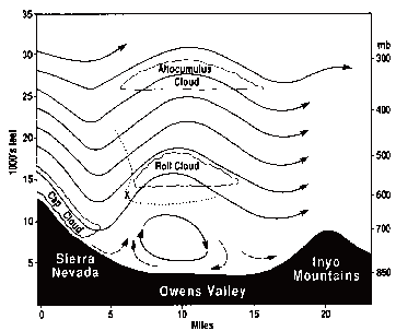
 ... otherwise known as diurnal orographic banner clouds and convective cloud development.